| Mount Wardle | |
|---|---|
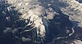
 South aspect | |
| Highest point | |
| Elevation | 2,805 m (9,203 ft) [1] [2] |
| Prominence | 362 m (1,188 ft) [1] |
| Parent peak | Mount Verendrye (3,085 m) [1] |
| Isolation | 2.61 km (1.62 mi) [1] |
| Listing | Mountains of British Columbia |
| Coordinates | 50°57′33″N116°01′12″W / 50.95917°N 116.02000°W [3] |
| Geography | |
 Mount Wardle Location in British Columbia  Mount Wardle Location in Canada | |
 | |
| Interactive map of Mount Wardle | |
| Location | Kootenay National Park British Columbia, Canada |
| District | Kootenay Land District |
| Parent range | Vermilion Range Canadian Rockies |
| Topo map | NTS 82K16 Spillimacheen |
| Geology | |
| Rock age | Cambrian [4] |
| Rock type | Ottertail Limestone [4] |
| Climbing | |
| First ascent | 1922 |
Mount Wardle is a 2,805-metre (9,203-foot) mountain summit located in British Columbia, Canada.