Natural forests in Sri Lanka

Last updated

Natural forests in Sri Lanka
Ecology
Realm Indomalayan
Biome Tropical forest
BordersIndian Ocean
Geography
Area10,825 km2 (4,180 sq mi)
Country Sri Lanka
Climate type Tropical climate

Sri Lanka exhibits a remarkable biological diversity [1] and is considered to be the richest country in Asia in terms of species concentration. [1]

Contents

In 2019 a total area of 16.5% [2] of Sri Lanka was forested. In 2010, it was 28.8% [3] (and 32.2% in 1995. [4] )

9.0% [5] of Sri Lanka's forests are classified as primary forest (the most biodiverse form of forest and the biggest carbon sinks on Earth).

Sri Lanka's forests contain 61 million metric tons of carbon in living forest biomass (in 2010 [5] ).

Between 1990 and 2005 alone, Sri Lanka lost 17.7% of its forest cover. [2]

History

Sri Lanka continental separated from the south eastern tip of peninsular India by the more than 20 m deep Palk Strait. There had been repeated land connections with India across this strait during successive glacial periods, the last being between 10,000 and 20,000 years ago when the sea level was about 120m below the present level creating a 140 km wide land bridge. Notwithstanding these intermittent land connections with India, when exchange of species undoubtedly would have taken place between the island and mainland, Sri Lanka fauna and flora, especially those in the south western quarter, show remarkably high diversity and extraordinary endemism. It is the only area of seasonal lowland climate between western Malaysia (Sumathra, Malay Peninsula, Borneo and Philippines) and eastern coastal Madagascar. [6]

Description

According to the National Red List said, Sri Lanka counts 253 land species, 245 species of butterflies, 240 birds, 211 reptiles, 748 evaluated vertebrates and 1,492 invertebrates. [7] Forest coverage is about 70% tropical dry monsoon forests, 15% tropical moist monsoon forests and 5% tropical lower montane forests. By the dawn of the 19th century, Sri Lanka's forest cover was estimated at up to 70% of the total land area. Since then, the forest cover has decreased progressively over time.

Features

Based on a global yardstick of concentrations of exceptional terrestrial biodiversity under threat, Sri Lanka and Western Ghats of southwestern India have been grouped together as one of the 34 global hotspots of biodiversity, implying that biologically they are among the richest and at the same time the most endangered terrestrial biogeographic region in earth. [8]

Ecosystems

Sri Lanka map of climate classification zones Koppen-Geiger Map LKA present.svg
Sri Lanka map of climate classification zones

Sri Lanka is in the north-equatorial tropical zone. Therefore it experiences a climate with high rainfall and temperature which permits the county to be broadly classified into groups as follows.

Classifications of eco systems in Sri Lanka [9]
Climatic zoneTemperatureRainfallAltitudeForestsGrasslands
Arid zone32-36 °C<1,000 mm<300 m Tropical thorn scrubs Arid
Dry zone28-32 °C1,000-1,500 mm<500 m Tropical dry mixed evergreen forests Damana grassland
Talawa grassland
Savanna
Intermediate zone24-28 °C1,250-2,000 mm500-1,500 m Tropical moist evergreen forests, Tropical sub montane forest Savanna
Dry patana
Wet zone16–28 °C>2,000 mm300-1,000 m Tropical lowland wet ever-green Talawa
900-1,500 mTropical sub-montaneDry Patana
>1,500 mTropical upper montaneWet Patana

Tropical wet low land rainforests

UNESCO World Heritage Site site Sinharaja Forest Reserve is an important forest in Sri Lanka. 20160128 Sri Lanka 4107 Sinharaja Forest Reserve sRGB (25468886730).jpg
UNESCO World Heritage Site site Sinharaja Forest Reserve is an important forest in Sri Lanka.

The tropical wet lowland rainforests are found below 900 m elevation in the south western quarter of the country. The mean annual temperature is about 28 °C, and the mean annual rainfalls varies between 2,000–5,000 mm in different locations without any dry period. The humidity is very high. These forests are characterized by a tall canopy, sub canopy and a sparse shrub layer consisting mostly of the saplings of canopy trees. Sometimes an emergent layer is also seen above the canopy. The vegetation is filled with a network of woody lianas that reach to the canopy layer. A diverse population of epiphytic lichens, mosses, liverworts ferns, orchids are found while many fungi inhabit decaying woods and soil. High endemism of floral and faunal diversity can be seen in these forests. ( Sinharaja, Nakiyadeniya and Kanneliya are some examples for wet lowlands rainforest) These forests are disturbed due to expansion of tea cultivation, agriculture, industrial and residential development. [10]

Some tree species found in the wet lowland rain forests are;

Some animal species found in the wet lowland rainforests are Purple faced langur, Sri Lanka Slender loris, Golden wet zone palm civet. [11]

Tropical montane forests

Tropical montane forests, Horton Plains National Park Sri Lanka, Horton Plains, Rhododendron trees in fog.jpg
Tropical montane forests, Horton Plains National Park

They occur at elevations above 1,500 m above mean sea level. The average temperature is about 16 °C and rainfall is about 2,000 mmm without any dry period. The humidity is high as lowland rainforests. These forests are characterized by a short canopy of about 13 m, with a dense shrub layer. There are trees with umbrella-shaped rounded crowns and twisted branches having leathery small leaves to accommodate the strong winds that prevail in the montane zone. High density of epiphytes cover the branches and stems of trees. Some plants found in these forests are;

Some animals that inhabit montane rainforests of Sri Lanka are Sri Lanka Yellow eared bulbul, Sri Lanka highland Shrew (Suncus montanus), Sambar (Rusa unicolor unicolor). [11]

Montane forests are distributed in central hills including Knuckles range, Piduruthalagala, Hakgala. Montane forests were greatly affected due to tea cultivation.

Tropical dry mixed evergreen forests/Dry monsoon forests

Tropical dry mixed evergreen forests, Yala National Park Scenery in Yala National Park.jpg
Tropical dry mixed evergreen forests, Yala National Park

These forests have a mean annual temperature of about 29 °C and rainfall around 1,000 mm- 1,500 mm most of which falls during the northeast monsoon periods. There is a marked dry spell from May to August. Above forests are distributed in areas below 300 m altitude. These forests are characterized by having sparse canopy, a sub canopy and a well-developed shrub/herb layer. Some plant species naturally found in these forests are [12]

Some of the canopy trees are deciduous during the dry spell of the year. These forests harbour the largest elephant populations in Asia. The mammal fauna includes Panthera pardus kotiya , Melursus ursinus , Axis axis ceylonensis . Most of the forest are protected ad National parks such as Yala National Park, Wilpattu National Park, Wasgamuwa National Park, Maduru-Oya national park, Ritigal Strict Nature reserve and many sanctuaries and forest reserves. These forests are disturbed by 'chena' cultivation, human settlements, extraction of timber, poaching etc. [10]

Tropical thorn scrubs

Tropical thorn scrubs, Mannar District Wilpattu National Park 3.jpg
Tropical thorn scrubs, Mannar District

These are called "scrubs" than "forests" as large trees are sparse and the vegetation is mainly consists of thorny shrubs. They are found in arid lowlands. The mean annual temperature is around 31 °C and rainfall is below 1,000 mm with a longer dry period. Due to the dry conditions, many fauna species can't be found. However Axis axis ceylonensis, Panthera pardus kotiya, Elephas maximus maximus can be seen in these areas. They are distributed near Hambantota, Yala, Mannar, Puttalam areas and disturbed due to various development pressures. [12]

The following plant species are commonly found;

Savanna

Savanna, Belihul Oya River (Horton Plains National Park) Belihul Oya River - Horton Plains National Park (4).jpg
Savanna, Belihul Oya River (Horton Plains National Park)

Savannas have a thick grass cover and few scattered trees. These are common on hill slopes of the dry or intermediate zone. The thin layer of soil on hill slopes can not support the growth of trees and the grass cover of savannas helps to bind soil particles and reduce erosion of soil. Periodic fires are common to this ecosystem as the dried grass cover easily catch fire in dry period of the year. They have trees with fire-resistant species. Savannas are seen in Bibile, Monaragala, Mahiyanganaya, Wellawaya and Horton Plains areas. These are distributed by periodic fires set by villagers for various reasons. [12]

Some plant species found in Savanna are trees are;

Patana

Dry Patana, Hantana At the highest peak in Hantana mountain range.jpg
Dry Patana, Hantana

There are two type of 'Patana' found in Sri Lanka; 'Wet Patana grassland' and 'Dry Patana grassland' based on the rainfall pattern and soil of the site. 'Wet Patana' grass lands are found in areas above 1,500 m from the sea level with mean annual rainfall of over 2,000 mm. Temperature range from 5 °C to 18 °C. Mist, fog and frost and frost are common in these areas and do not experience any dry period. The grasses do not reach more than 1 m height and are called 'tussock' grasses which include the Chrysopogon nodulibarbis and Arundinella villosa. The animals include a large Sri Lankan sambar and Wild-boare population and few Sri Lankan leopards (Panthera pardus kotiya). Extensive 'Wet Patana' are found only in Horton plains. 'Dry Patana' are found in altitudes between 500 m to 1,600 m. They receive a rainfall about 1,400 to 2,000 mm with a definite dry period. Temperature ranges from 18 °C to 24 °C. The vegetation is made up of grasses that grow up to 1–2 m height such as Cymbopogon nardus and Themeda tremula. 'Dry Patana' is common on hill tops in Hanthana, Gampola, Welimada and Haputale. [12]

Wetlands

Wetlands are simply habitats with permanent or temporary accumulation of water with associated plant and animals. According to Ramasar Convention, [13] wetlands are defined as areas of marsh, fen, peatland or water, whether natural or salt, including areas of marine water the depth of which at low tide not exceed six metres. [14]

Marshes and swamp forests

Inland freshwater marshlands are low-lying areas that receive water through surface runoff, ground water seepage or flood water from rivers. These contain peat (partially decomposed organic matter), and water-logged sticky clay soil. Many water birds, amphibians and fresh species inhabit these areas. Plants that have adapted to grow in shallow stagnant water such as Colocassi spp., Aponogeton spp., species are abundant in inland marshlands. Freshwater swamp forests are not common in Sri Lanka. It is a place where forest vegetation is inundated for a short period of time in the year as seen in Waturana swamp at Bulathsinhala located in the 'Kalu Ganga' river basin. [15]

Villus

Villu, Wilpattu National Park Beauty of Wilpattu National Park.jpg
Villu, Wilpattu National Park

Generally 'villus' are the flood plains of the reservoirs. 'Villu' grasslands possess a special link with the wildlife in the area, especially elephants and bird population. The vegetation is dominant with grasses (members of Poaceae )and sedge (member of Cyperaceae ). 'Villu' grasslands are located in areas such as Mahawelli flood plains, Wilpattu National Park. [15]

Lagoons and estuaries

Lagoons are coastal wetlands generally separated from the sea by a sand barries. [16] (eg. Negambo and Bundala lagoons) Estuaries are formed in places where rivers enter the sea and does not contain a sand barriers separating it from seas.(eg. Madu Ganga/Benthota) The daily tidal fluctuation is a characteristic of these places. [17]

Mangroves

Mangroves, Madu ganga Maduganga Mangrove1.jpg
Mangroves, Madu ganga

Mangroves ecosystem is an intertidal vegetation that covers fringes of the lagoons and estuaries. They share characteristics usually of saline/brackish water, loose soil and anoxic conditions. The vegetation is also exposed to intense sunlight. Mangrove plants could be categorized into groups; true mangroves that occur towards the boundary between sea and land and mangrove associated that occur more towards inland common true mangrove species are; [18]

Common mangrove associate are;

To protect from sunlight leaves of the mangrove have a thick cuticle to reflect sunrays and/ or cut off excess radiation. Some have salt glands to secrete excess salts that are absorbed by the plants. There are special roots to intake atmospheric oxygen. Seeds of some mangroves germinate while attached to the mother plant ("vivipary"). This helps the seed to establish successfully soon after falling from the tree. Mangroves provide a unique habitat mainly for many crustaceans and mollusks. Mangroves are found in Puttalam, Batticaloa, Trincomalee, Galle, Bentota and Negambo. [14]

Salt marshes

Salt marshes, Mannar Palmyras of Mannar.jpg
Salt marshes, Mannar

Salt marshes are marshlands restricted to the arid coastal regions of the country where soil dries up to form crystals of salts during the dry season. Low rainfall, high wind, high temperatures and losses sand blowing with salt are some of the major characteristics found in this ecosystem. The vegetation has only few plant and animal species. Plant are short, contain fleshy succulent plant bodies one common plant species is Salicornia spp. salt marshes are common in Puttalam, Mannar, Hambantota and Vakarai areas. [19]

Sea grass beds

In large lagoon areas with low wave action, the floor of the shallow sea is occupied by sea grasses. These are not grass species but appear like grasses due to the shape of leaves. (eg. plant species such as Halodule spp. and Halophyla spp. are common sea grasses found in Sri Lanka) Especially from Kalpitiya to Mannar. Sea grasses grow in a compact cluster and provides the sea bed a favourable habitat for breeding of many fish species. However, these areas are often disturbed by the fisheries activities as these are the parking areas of fishing boats. [14]

Coral reefs

Coral reefs are one of the natural wonders of Sri Lanka. Coastline of about 1,585 km, has nearshore coral reefs of varying quality along 2% of the liner coast. The most extensive coral reefs occur off the north west and east coast up to and around the Jaffna Peninsula. The greatest extent of true corals in Sri Lanka lie in patchy reefs from Vakalai to the Kalpitiya peninsula. These offer the most varied reef access from snorkelling on shallow reefs to scuba diving on deeper reefs. Patchy coral reefs are also found on the western and eastern seaboards at a distance of about 15–20 km from the shore, at an average depth of 20m. Passekudah and Trincomalee have the best coral reefs on the Eastern Maritime Province seaboard. Hikkaduwa, Unawatuna, Rumassala and Matara have the main fringing reefs along the southern coast. Little Basses and Great Basses off the south coast have the best barrier like reefs in Sri Lanka. [20]

Rivers and streams

Sri Lanka has an extensive network of rivers, which drains a total of 103 distinct natural river basins. The river basins originating in the wet highlands are perennial, while many of those in dry zone are seasonal. There is hardly any vegetation to be found in running water. [15]

Reservoirs

Largest artificial reservoir, Parakrama Samudra was built in Polonnaruwa Kingdom by King Parakramabahu I (1153-1186). Parakrama Samudra Tank Polonnaruwa.jpg
Largest artificial reservoir, Parakrama Samudra was built in Polonnaruwa Kingdom by King Parakramabahu I (1153–1186).

There are no natural lakes in Sri Lanka, but there are numerous ancient irrigation tanks mainly scattered in the low land dry zone. Typical irrigation tanks include "Parakrama Samudra", "Kala Wewa"", "Minneriya wewa" and "Tissa wewa".

Sea shore

The long sea shore of Sri Lanka varies in nature. The most common sea shore type is sandy sea shores. The sea shore areas share the characteristics of high temperature throughout, and slat spray and high winds especially during the monsoon seasons. Most of the sea shore plants have adapted to these conditions. Examples for these plants are, [19]

  • Si: Muhudu Bimthamburu, En: Beach Morning Glory, Ta: Atampu ( Ipomea pescaprae )
  • Si: Maha rawana revula, Ta: Ravannan meesai (Spinifex littoreus)

The vegetation gradually become stable a distance away from the tide mark, with the stabilization of the soil. In these areas plant species such as,

Sand Dunes

Sand dunes are characterized by stunted or creping vegetation on large masses of sand. The sand dune structure is determined by wind speed and direction. Dunes are raised beaches of sand and are characteristic of certain coastal areas in the arid zone. Example: near Mullativu, Trincomalee, Kalpitiya, Yala etc. [17]

Deforestation

In 1882, 82% of Sri Lanka was forested. [2]

Between 1990 and 2000, Sri Lanka lost an average of 1.14% of its forest per year. [2]

In total, between 1990 and 2005 alone, Sri Lanka lost 17.7% of its forest cover. [2]

Causes and Impacts

Large scale agricultural and settlement schemes without the recognition given for wild animal habitats and their migration patterns have been a major driver of deforestation and degradation, particularly in the dry zone, during the last century. Planted crops, such as sugar cane, banana, maize and paddy, in an unplanned manner, have led to ever-increasing human-elephant conflicts. Sri Lanka current forest cover 16.5% in 2019 down form 29.7% in 2017. [21]

Related Research Articles

<span class="mw-page-title-main">Geography of Sri Lanka</span> Geography of a country

Sri Lanka, formerly called Ceylon, is an island nation in the Indian Ocean, southeast of the Indian subcontinent, in a strategic location near major sea lanes. The nation has a total area of 65,610 square kilometres (25,330 sq mi), with 64,630 square kilometres (24,950 sq mi) of land and 980 square kilometres (380 sq mi) of water. Its coastline is 1,340 kilometres (830 mi) long. The main island of Sri Lanka has an area of 64, 058 km2; it is the twenty-fifth largest island in the world by area. Dozens of offshore islands account for the remaining 1552 km2 area. The largest offshore island, Jaffna Island is separated by Chundikulam lagoon and Mannar Island, is linked to Adam's Bridge, a land connection to the Indian mainland, which is now mostly submerged with only a chain of limestone shoals remaining above sea level. According to temple records, this natural causeway was formerly whole, but was breached by a violent storm in 1480. The formation is also known as Rama's Bridge, as according to Hindu mythology, it was constructed during the rule of Lord Rama.

<span class="mw-page-title-main">Tropical and subtropical moist broadleaf forests</span> Habitat type defined by the World Wide Fund for Nature

Tropical and subtropical moist broadleaf forests (TSMF), also known as tropical moist forest, is a subtropical and tropical forest habitat type defined by the World Wide Fund for Nature.

<span class="mw-page-title-main">Mascarene Islands</span> Group of islands in the Indian Ocean

The Mascarene Islands or Mascarenes or Mascarenhas Archipelago is a group of islands in the Indian Ocean east of Madagascar consisting of the islands belonging to the Republic of Mauritius as well as the French department of La Réunion. Their name derives from the Portuguese navigator Pedro Mascarenhas, who first visited them in April 1512. The islands share a common geologic origin in the volcanism of the Réunion hotspot beneath the Mascarene Plateau and form a distinct ecoregion with a unique flora and fauna.

<span class="mw-page-title-main">Horton Plains National Park</span> National park in Sri Lanka

Horton Plains National Park is a national park in the central highlands of Sri Lanka that was designated in 1988. It is located at an elevation of 2,100–2,300 m (6,900–7,500 ft) and encompasses montane grassland and cloud forest. It is rich in biodiversity and many species found here are endemic to the region. It is also a popular tourist destination and is situated 8 kilometres (5.0 mi) from Ohiya, 6 kilometres (3.7 mi) from the world-famous Ohiya Gap/Dondra Watch and 32 kilometres (20 mi) from Nuwara Eliya.

<span class="mw-page-title-main">Vanuatu rain forests</span>

The Vanuatu rain forests are tropical and subtropical moist broadleaf forests ecoregion which includes the islands of Vanuatu, as well as the Santa Cruz Islands group of the neighboring Solomon Islands. It is part of the Australasian realm, which includes neighboring New Caledonia and the Solomon Islands, as well as Australia, New Guinea, and New Zealand.

<span class="mw-page-title-main">Yala National Park</span> National park in Sri Lanka

Yala (යාල) National Park is the most visited and second largest national park in Sri Lanka, bordering the Indian Ocean. The park consists of five blocks, three of which are now open to the public. There are also two adjoining parks, Kumana National Park or 'Yala East' and Lunugamvehera National Park. The blocks have individual names, such as Palatupana. It is situated in the southeastern region of the country, in the Southern Province and Uva Province. The park covers 979 square kilometres (378 sq mi) and is located about 300 kilometres (190 mi) from Colombo. Yala was designated as a wildlife sanctuary in 1900, along with Wilpattu, designated in 1938, as the first two designated national parks in Sri Lanka. The park is best known for its variety of wildlife and is important conservation of Sri Lankan elephants, Sri Lankan leopards and aquatic birds.

<span class="mw-page-title-main">Hawaiian tropical rainforests</span>

The Hawaiian tropical rainforests are a tropical moist broadleaf forest ecoregion in the Hawaiian Islands. They cover an area of 6,700 km2 (2,600 sq mi) in the windward lowlands and montane regions of the islands. Coastal mesic forests are found at elevations from sea level to 300 m (980 ft). Mixed mesic forests occur at elevations of 750 to 1,250 m, while wet forests are found from 1,250 to 1,700 m. Moist bogs and shrublands exist on montane plateaus and depressions. For the 28 million years of existence of the Hawaiian Islands, they have been isolated from the rest of the world by vast stretches of the Pacific Ocean, and this isolation has resulted in the evolution of an incredible diversity of endemic species, including fungi, mosses, snails, birds, and other wildlife. In the lush, moist forests high in the mountains, trees are draped with vines, orchids, ferns, and mosses. This ecoregion includes one of the world's wettest places, the slopes of Mount Waiʻaleʻale, which average 373 in (9,500 mm) of rainfall per year.

<span class="mw-page-title-main">Environment of Sri Lanka</span>

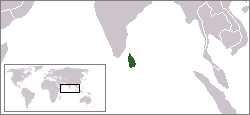
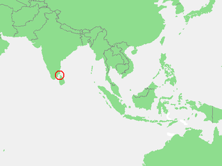
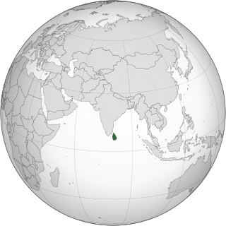
The environment of Sri Lanka exhibits a remarkable biodiversity.

<span class="mw-page-title-main">Sri Lanka dry-zone dry evergreen forests</span> Ecoregion in Sri Lanka

The Sri Lanka dry-zone dry evergreen forests are a tropical dry broadleaf forest ecoregion of the island of Sri Lanka.

<span class="mw-page-title-main">Sri Lanka montane rain forests</span> Ecoregion in Sri Lanka

The Sri Lanka montane rain forests is an ecoregion found above 1,000 m in the central highlands of Sri Lanka. Owing to their rich biodiversity, this region is considered to be a super-hotspot within endemic hotspots of global importance. These forests are cooler than lowland forests and therefore they have ideal conditions for growth of cloud forests. These forests classifications tropical sub montane forest, tropical sub-montane and tropical upper montane. Half of Sri Lanka's endemic flowering plants and 51 percent of the endemic vertebrates are restricted to these forests. More than 34 percent of Sri Lanka's endemic trees, shrubs, and herbs can only be found in this ecoregion. Twisted, stunted trees are a common sight in these forests, together with many varieties of orchids, mosses and ferns. The trees of montane rain forests grow to a height 10–15 meters, shorter than the lowland rain forest trees. These high altitude forests are the catchment area for most of Sri Lanka's major rivers.

The Shoalwater Bay Military Training Area is a heritage-listed military installation at Byfield Road, Byfield, Shire of Livingstone, Queensland, Australia. It is a large, relatively undisturbed and intact natural system with a wide variety of coastal landforms and a high level of biodiversity. It contains a diverse range of marine and coastal wetland landscapes, vegetation types and ecosystems. It was added to the Australian Commonwealth Heritage List on 22 June 2004.

A tropical marine climate is a tropical climate that is primarily influenced by the ocean. It is usually experienced by islands and coastal areas 10° to 20° north and south of the equator. There are two main seasons in a tropical marine climate: the wet season and the dry season. The annual rainfall is 1000 to over 1500 mm. The temperature ranges from 20 °C to 35 °C. Under the Köppen climate classification, a "tropical marine climate" would fall under Af or Am, tropical rainforest or tropical monsoon climate. The trade winds blow all year round and are moist, as they pass over warm seas. These climatic conditions are found, for example, across the Caribbean, the eastern coasts of Brazil, Madagascar and Queensland; and many islands in tropical waters.

<span class="mw-page-title-main">Sri Lanka lowland rain forests</span> Ecoregion in Sri Lanka

The Sri Lanka lowland rain forests represents Sri Lanka's Tropical rainforests below 1,000 m (3,281 ft) in elevation in the southwestern part of the island. The year-around warm, wet climate together with thousands years of isolation from mainland India have resulted in the evolution of numerous plants and animal species that can only be found in rain forests in Sri Lanka. The thick forest canopy is made up of over 150 species of trees, some of the emergent layer reaching as high as 45 m (148 ft). The lowland rain forests accounts for 2.14 percent of Sri Lanka's land area. This ecoregion is the home of the jungle shrew, a small endemic mammal of Sri Lanka. Sri Lanka has the highest density of amphibian species worldwide. Many of these, including 250 species of tree frogs, live in these rain forests.

<span class="mw-page-title-main">Bundala National Park</span> National park in Sri Lanka

Bundala National Park is an internationally important wintering ground for migratory water birds in Sri Lanka. Bundala harbors 197 species of birds, the highlight being the greater flamingo, which migrate in large flocks. Bundala was designated a wildlife sanctuary in 1969 and redesignated to a national park on 4 January 1993. In 1991 Bundala became the first wetland to be declared as a Ramsar site in Sri Lanka. In 2005 the national park was designated as a biosphere reserve by UNESCO, the fourth biosphere reserve in Sri Lanka. The national park is situated 245 kilometres (152 mi) southeast of Colombo.

<span class="mw-page-title-main">Arnhem Land tropical savanna</span> Ecoregion in Northern Territory, Australia

The Arnhem Land tropical savanna is a tropical and subtropical grasslands, savannas, and shrublands ecoregion in Australia's Northern Territory.

<span class="mw-page-title-main">Kimberley tropical savanna</span> Terrestrial ecoregion in Western Australia

The Kimberley tropical savanna is a tropical and subtropical grasslands, savannas, and shrublands ecoregion in northwestern Australia, covering portions of Western Australia and the Northern Territory south of the Timor Sea.

<span class="mw-page-title-main">Climate change in Sri Lanka</span> Emissions, impacts and responses of Sri Lanka related to climate change

Climate change is an important issue in Sri Lanka, and its effects threaten to impact both human and natural systems. Roughly 50 percent of its 22 million citizens live in low-lying coastal areas in the west, south, and south-west of the island, and are at risk of future sea level rise. Climate change also threatens the island's biodiversity, including its marine ecosystem and coastal coral reef environments. Sea-level rise due to climate change has the potential to affect the overall abundance of endemic species. Sri Lanka's coastal regions, such as the Northern Province and the Northern Western Province, are considered major hotspots and extremely vulnerable to climate change. These maritime provinces are the most densely populated. In addition to being a threat to Sri Lanka's biodiversity, climate change may cause disastrous consequences on various levels in such areas. Such consequences include: Affecting agricultural productivity, causing natural disasters like floods and droughts, increasing the spread of infectious illnesses, and finally undermining the living standards.

<span class="mw-page-title-main">Maldives–Lakshadweep–Chagos Archipelago tropical moist forests</span> Broadleaf forest region in South Asia

The Maldives–Lakshadweep–Chagos Archipelago tropical moist forests is a tropical moist broadleaf forest ecoregion in South Asia. It spans a chain of coralline islands in the Indian Ocean, including Lakshadweep, a union territory of India; the Maldives, an independent country; and the British Indian Ocean Territory, an overseas territory of the United Kingdom.

<span class="mw-page-title-main">Tongan tropical moist forests</span>

The Tongan tropical moist forests is a tropical and subtropical moist broadleaf forests ecoregion that includes the Tonga archipelago and Niue.

References

  1. 1 2 Convention on Biological Diversity (a part of the UN environment programme)
  2. 1 2 3 4 5 thediplomat.com
  3. According to the U.N. FAO : https://rainforests.mongabay.com/deforestation/2000/Sri_Lanka.htm
  4. "FRA 2000 – Forest resources of Sri Lanka – Country report". www.fao.org. Retrieved 19 January 2021.
  5. 1 2 "Sri Lanka Forest Information and Data".
  6. Gunatulleke, Nimal (2012). Sri Lanka Rainforest Origin Story. Colombo: National Academy of Sciences of Sri Lanka.
  7. Unit, Biosafety. "Main Details". www.cbd.int. Retrieved 19 January 2021.
  8. "Explore the Biodiversity Hotspots | CEPF". www.cepf.net. Retrieved 20 January 2021.
  9. National Atlas of Sri Lanka, 2nd Edition. Colombo: Survey Department of Sri Lanka. 2012.
  10. 1 2 National Biodiversity Strategic Action Plan 2016–2022. Colombo: Biodiversity Secretariat, Ministry of Mahaweli Development and Environment. 2016.
  11. 1 2 3 4 5 6 7 The National Red List 2012 of Sri Lanka. Colombo: Ministry of Environment. 2012.
  12. 1 2 3 4 Cramer, L.H. (1993). A Forest Arboretum in the Dry Zone. Kandy: National Institute of Fundamental Studies (NIFS).
  13. "Sri Lanka | Ramsar". www.ramsar.org. Retrieved 22 January 2021.
  14. 1 2 3 4 Nimal Gunathilaka, Magoda Jayasuriya, Devaka Weerakoon, Savitri Gunathilaka (2014). Sri Lanka's Forests – Nature at your service. Sri Lanka Association for the Advancement of Science.{{cite book}}: CS1 maint: multiple names: authors list (link)
  15. 1 2 3 Central Environmental Authority, IUCN, IWMI (2006). "National Wetland Directory of Sri Lanka" (PDF). Central Environmental Authority Sri Lanka.{{cite web}}: CS1 maint: multiple names: authors list (link)
  16. Amerasinghe, Felix P.; Matsuno, Y.; de Silva, R. I.; Piyankarage, Sujeewa C.; Bambaradeniya, C. N. B.; Mallawatanthri, A. (2002). Impact of irrigation on water quality, fish and avifauna of three coastal lagoons in Southern Sri Lanka. Sri Lanka: International Water Management Institute. hdl:10568/37003.{{cite book}}: CS1 maint: multiple names: authors list (link)
  17. 1 2 Miththapala, Sriyanie (2013). Lagoons and Estuaries Coastal Ecosystems Series (Volume 4). Colombo 07, Sri Lanka: IUCN Sri Lanka. pp. 41–43. ISBN   978-955-0205-21-9.{{cite book}}: CS1 maint: location (link)
  18. Bambaradeniya CNB, Perera N and Chandranimal D (2006). Biodiversity associated with the Ittapana mangrove in Benthota estuary, Sri Lanka, Unpublished report. Colombo.{{cite book}}: CS1 maint: location missing publisher (link)
  19. 1 2 Pemadasa, M.A., Balasubramaniam, S., Wijew- Ansa, H.G. and Amarasinghe, L. (1979). The ecology of a salt marsh in Sri Lanka. Peradeniya, Sri Lanka: Journal of Ecology University of Peradeniya. pp. 67, 41–63.{{cite book}}: CS1 maint: multiple names: authors list (link)
  20. "5 Coral Reefs of Sri Lanka: Current Status And Resource Management by Arjan Rajasuriya1". www.fao.org. Retrieved 22 January 2021.
  21. "Fighting Deforestation in Sri Lanka". thediplomat.com. Retrieved 4 March 2021.