Whitewater forms in a rapid context, in particular, when a river's gradient changes enough to generate so much turbulence that air is trapped within the water. This forms an unstable current that froths, making the water appear opaque and white.

Canyoning is travelling in canyons using a variety of techniques that may include other outdoor activities such as walking, scrambling, climbing, jumping, abseiling (rappelling), and swimming.

Ernakulam, IPA: [erɐɳɐːguɭɐm]; IAST: Eṟaṇākuḷaṁ, in Malayalam: എറണാകുളം) is a district of Kerala, India, that takes its name from the eponymous city division in Kochi. It is situated in the central part of the state, spans an area of about 3,000 square kilometres (1,200 sq mi), and is home to over 9% of Kerala's population. Its headquarters are located at Kakkanad. The district includes Kochi, also known as the commercial capital of Kerala, which is famous for its ancient Hindu temples, churches, and mosques. The district includes the largest metropolitan region of the state: Greater Cochin. Ernakulam is the district that yields the most revenue and the largest number of industries in the state. Ernakulam is the third most populous district in Kerala, after Malappuram and Thiruvananthapuram. The district also hosts the highest number of international and domestic tourists in Kerala state.

Pictured Rocks National Lakeshore is a U.S. National Lakeshore on the shore of Lake Superior in the Upper Peninsula of Michigan, United States. It extends for 42 miles (67 km) along the shore and covers 73,236 acres. The park has extensive views of the hilly shoreline between Munising and Grand Marais in Alger County, Michigan, with picturesque rock formations, waterfalls, and sand dunes.

Idukki (ഇടുക്കി), IPA: [iɖukːi], is a district in the Indian state of Kerala. It was constituted on 26 January 1972, by splitting the district of Kottayam into two parts. Its division was previously headquartered at Kottayam city, but moved to Kuyilimala near Painavu and Cheruthoni in June 1976. Idukki district lies amid the Cardamom Hills of Western Ghats in Kerala.

The St Thomas Syro Malabar Catholic International Shrine, Malayattoor is one of the eight international shrines in the world, situated in Malayattoor Angamaly, Ernakulam district of Kerala, India.

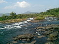
Periyar, IPA: [peɾijɐːr], is the longest river and the river with the largest discharge potential in the Indian state of Kerala. It is one of the few perennial rivers in the region and provides drinking water for several major towns. The Periyar is of utmost significance to the economy of Kerala. It generates a significant proportion of Kerala's electrical power via the Idukki Dam and flows along a region of industrial and commercial activity. The river also provides water for irrigation and domestic use throughout its course besides supporting a rich fishery. Due to these reasons, the river has been named the "Lifeline of Kerala". Kochi city, in the vicinity of the river mouth draws its water supply from Aluva, an upstream site sufficiently free of seawater intrusion. Twenty five percent of Kerala's industries are along the banks of river Periyar. These are mostly crowded within a stretch of 5 kilometres (3 mi) in the Eloor-Edayar region (Udhyogamandal), about 10 kilometres (6 mi) north of Kochi harbor.

Tohickon Creek is a 29.5-mile-long (47.5 km) tributary of the Delaware River. Located entirely in Bucks County, in southeastern Pennsylvania, it rises in Springfield Township and has its confluence with the Delaware at Point Pleasant. It is dammed to form Lake Nockamixon.
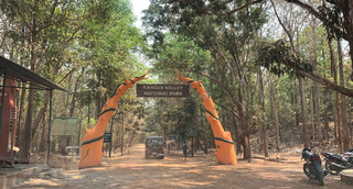
Kanger Ghati National Park was declared a national park in 1982 by the Government of India. Near Jagdalpur in the Bastar region of Chhattisgarh, it is one of India's densest national parks, and is known for its biodiversity, landscape, waterfalls, and subterranean geomorphologic limestone caves, and as the home of the Bastar hill myna, the state bird of Chhattisgarh.

Chalakudy River or Chalakudy Puzha is the fifth longest river in Kerala, India. The river flows through Thrissur district, Palakkad district and Ernakulam district of Kerala. The total drainage area of the river is 1704 km2. out of this 1404 km2 lies in Kerala and the rest 300 km2 in Tamil Nadu. The length of the river is 145.5 km. Though Chalakudy river in strict geological sense is a tributary of the Periyar river, for all practical purposes it is treated as a separate river by Government and other agencies. The River has gained its name, since it flows along the banks of the Chalakudy Town, the major settlement along the course of the river. It is perhaps the most unpolluted and pristine river in the state and even in India due to the limited amount of industries and wastage disposal around it. Chalakudy River and its basin area were one of the most affected rivers during the 2018 Kerala floods.

Kodanad is a rural riverside village of Ernakulam district in Kerala, South India. It is 18 km from Angamaly. Kodanad is situated on the south bank of Periyar river, about 42 kilometers east of Kochi. The nearest airport is Cochin International Airport which is about 20 km (12 mi) by road. The village is a major tourist destination because it houses an Elephant training center.

River surfing is the sport of surfing either standing waves, tidal bores or upstream waves in rivers. Claims for its origins include a 1955 ride of 2.4 km (1.5 mi) along the tidal bore of the River Severn.

Bhoothathankettu is a dam and tourist spot in Ernakulam district in Kerala, India. It is situated outside the village of Pindimana, about 10 km away from the town of Kothamangalam and 50 km away from the main city of Kochi. The original natural dam has been supplemented by a modern dam impounding the Bhoothathankettu Reservoir.

The Geology of Pennsylvania consists of six distinct physiographic provinces, three of which are subdivided into different sections. Each province has its own economic advantages and geologic hazards and plays an important role in shaping everyday life in the state. They are: the Atlantic Coastal Plain Province, the Piedmont Province, the New England Province, the Ridge and Valley Province, the Appalachian Plateau Province, and the Central Lowlands Province.
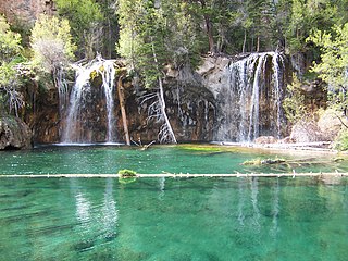
Hanging Lake is a lake in the U.S. State of Colorado. It is located in Glenwood Canyon, about 7 miles (11 km) east of Glenwood Springs, Colorado and is a popular tourist destination. When open, the lake is reached via a trailhead located along the Glenwood Canyon Bike and Pedestrian Path that runs along the north side of I-70 in the bottom of the canyon. The trail follows Dead Horse Creek, a tributary of the Colorado River and ascends some 1,000 feet (300 m) in elevation for 1.6 miles (2.6 km) from the trailhead to the lake.

A point bar is a depositional feature made of alluvium that accumulates on the inside bend of streams and rivers below the slip-off slope. Point bars are found in abundance in mature or meandering streams. They are crescent-shaped and located on the inside of a stream bend, being very similar to, though often smaller than, towheads, or river islands.

The Stone Forest or Shilin is a notable set of limestone formations about 500 km2 located in Shilin Yi Autonomous County, Yunnan Province, People's Republic of China, near Shilin approximately 90 km (56 mi) from the provincial capital Kunming.

The Bode Gorge is a 10 kilometres (6.2 mi) long ravine that forms part of the Bode valley between Treseburg and Thale in the Harz Mountains of central Germany. The German term, Bodetal, is also used in a wider sense to refer to the valleys of the Warme and Kalte Bode rivers that feed the River Bode.

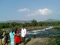
Malayattoor is a village in Angamaly Block Panchayth. It is situated around 15 km (9 mi) north-east of Angamaly in Ernakulam District in the state of Kerala in South India. The name `Malayattoor' is an amalgamation of three small words. Mala (Mountain) Arr (River) Oore (Place). This is to say, Malayattoor is a meeting place of mountain, river, and land.

Kaprikad is a rural riverside village of Ernakulam district, Kerala, southern India. Kaprikad is situated on the south bank of Periyar river, about 42 kilometers east of Kochi. The nearest airport is Cochin International Airport which is about 18 km (12 mi) by road. The village is a major tourist destination in the district because it houses the Kodanad Abhayaranyam animal shelter and elephant training centre.