Pichincha Volcano

Last updated
Pichincha
Rucu Pichincha and Trail.jpg
Ruku Pichincha as seen from the trail from Quito to the top
Highest point
Elevation 4,784 m (15,696 ft)
Prominence 1,652 m (5,420 ft)
Listing Ultra
Coordinates 0°10′16″S78°35′53″W / 0.171°S 78.598°W / -0.171; -78.598 Coordinates: 0°10′16″S78°35′53″W / 0.171°S 78.598°W / -0.171; -78.598
Geography
Equador physical map.svg
Red triangle with thick white border.svg
Pichincha
Parent range Andes
Geology
Age of rock Pleistocene
Mountain type Stratovolcano
Volcanic arc/belt North Volcanic Zone
Last eruption October to December 2002 [1]
Climbing
First ascent 1582 by José Ortiguera and others (first recorded ascent of Guagua Pichincha). [2]

Pichincha is an active stratovolcano in the country of Ecuador, whose capital Quito wraps around its eastern slopes. The two highest peaks of the mountain are Wawa Pichincha (Kichwa wawa child, baby / small, [3] Hispanicized spelling Guagua Pichincha) (4,784 metres (15,696 ft)) and Ruku Pichincha (Kichwa ruku old person, [3] Hispanicized Rucu Pichincha) (4,698 metres (15,413 ft)). The active caldera is in Wawa Pichincha on the western side of the mountain. [4]

Stratovolcano Tall, conical volcano built up by many layers of hardened lava and other ejecta

A stratovolcano, also known as a composite volcano, is a conical volcano built up by many layers (strata) of hardened lava, tephra, pumice and ash. Unlike shield volcanoes, stratovolcanoes are characterized by a steep profile with a summit crater and periodic intervals of explosive eruptions and effusive eruptions, although some have collapsed summit craters called calderas. The lava flowing from stratovolcanoes typically cools and hardens before spreading far, due to high viscosity. The magma forming this lava is often felsic, having high-to-intermediate levels of silica, with lesser amounts of less-viscous mafic magma. Extensive felsic lava flows are uncommon, but have travelled as far as 15 km (9.3 mi).

Ecuador Republic in South America

Ecuador, officially the Republic of Ecuador, is a country in northwestern South America, bordered by Colombia on the north, Peru on the east and south, and the Pacific Ocean on the west. Ecuador also includes the Galápagos Islands in the Pacific, about 1,000 kilometres (620 mi) west of the mainland. The capital city is Quito, which is also the largest city.

Quito Capital city in Pichincha, Ecuador

Quito is the capital and the largest city of Ecuador, and at an elevation of 2,850 metres (9,350 ft) above sea level, it is the second-highest official capital city in the world, after La Paz, and the one which is closest to the equator. It is located in the Guayllabamba river basin, on the eastern slopes of Pichincha, an active stratovolcano in the Andes Mountains.

Contents

Description

Both peaks are visible from the city of Quito and both are popular acclimatization climbs. Wawa Pichincha is usually accessed from the village of Lloa outside of Quito. Ruku is typically accessed from the TelefériQo on the western side of Quito. In October 1999, the volcano erupted and covered the city with several inches of ash. Before that, the last major eruptions were in 1553 [5] and in 1660, when about 30 cm of ash fell on the city.

Acclimatization or acclimatisation is the process in which an individual organism adjusts to a change in its environment, allowing it to maintain performance across a range of environmental conditions. Acclimatization occurs in a short period of time, and within the organism's lifetime. This may be a discrete occurrence or may instead represent part of a periodic cycle, such as a mammal shedding heavy winter fur in favor of a lighter summer coat. Organisms can adjust their morphological, behavioral, physical, and/or biochemical traits in response to changes in their environment. While the capacity to acclimate to novel environments has been well documented in thousands of species, researchers still know very little about how and why organisms acclimate the way that they do.

TelefériQo aerial lift

The TelefériQo, or TelefériQo Cruz Loma, is a gondola lift in Quito, Ecuador, running from the edge of the city centre up the east side of Pichincha Volcano to lookout Cruz Loma. It is one of the highest aerial lifts in the world, rising from 3,117 m (10,226 ft) to 3,945 m (12,943 ft). The ascent takes about twenty minutes, traveling 2,237 linear metres.

Volcanic ash volcanic material formed during explosive eruptions with the diameter of the grains less than 2 mm

Volcanic ash consists of fragments of pulverized rock, minerals and volcanic glass, created during volcanic eruptions and measuring less than 2 mm (0.079 inches) in diameter. The term volcanic ash is also often loosely used to refer to all explosive eruption products, including particles larger than 2 mm. Volcanic ash is formed during explosive volcanic eruptions when dissolved gases in magma expand and escape violently into the atmosphere. The force of the escaping gas shatters the magma and propels it into the atmosphere where it solidifies into fragments of volcanic rock and glass. Ash is also produced when magma comes into contact with water during phreatomagmatic eruptions, causing the water to explosively flash to steam leading to shattering of magma. Once in the air, ash is transported by wind up to thousands of kilometers away.

The province in which it is located takes its name from the mountain, as is the case for many of the other provinces in Ecuador (including Cotopaxi, Chimborazo, and Imbabura).

Pichincha Province Province in Ecuador

Pichincha is a province of Ecuador located in the northern sierra region; its capital and largest city is Quito. It is bordered by Imbabura and Esmeraldas to the north, Cotopaxi and Santo Domingo de los Tsáchilas to the south, Napo and Sucumbíos to the east, and Esmeraldas and Santo Domingo de los Tsáchilas to the west.

Cotopaxi Province Province in Ecuador

Cotopaxi is one of the provinces of Ecuador. The capital is Latacunga. The province contains the Cotopaxi Volcano, an intermittent volcano with a height of 19,388 feet.

Chimborazo Province Province in Ecuador

Chimborazo is a province in the central Ecuadorian Andes. It is a home to a section of Sangay National Park. The capital is Riobamba. The province contains Chimborazo, Ecuador's highest mountain.

Geography and geology

Eruptions

In 1660, Pichincha underwent a Plinian eruption, [6] spreading ash over 1,000 kilometres (620 mi), with over 30 centimetres (12 in) of ash falling on Quito. [1]

The most recent significant eruption began in August 1998. [1] On March 12, 2000, a phreatic eruption killed two volcanologists who were working on the lava dome. [7]

Phreatic eruption Volcanic eruption caused by an explosion of steam

A phreatic eruption, also called a phreatic explosion, ultravulcanian eruption or steam-blast eruption, occurs when magma heats ground or surface water. The extreme temperature of the magma causes near-instantaneous evaporation to steam, resulting in an explosion of steam, water, ash, rock, and volcanic bombs. At Mount St. Helens, hundreds of steam explosions preceded a 1980 plinian eruption of the volcano. A less intense geothermal event may result in a mud volcano.

History

The first recorded ascent of Guagua Pichincha was in 1582 by a group of locals led by José Ortiguera. [2]

In 1737 several members of the French Geodesic Mission to the Equator, including Charles-Marie de La Condamine, Pierre Bouguer and Antonio de Ulloa, spent 23 days on the summit of Rucu Pichincha as part of their triangulation work to calculate the length of a degree of latitude. [8]

On 17 June 1742, during the same mission, La Condamine and Bouguer made an ascent of Guagua Pichincha and looked down into the crater of the volcano, which had last erupted in 1660. La Condamine compared what he saw to the underworld. [9]

On May 24, 1822, General Sucre's southern campaign in the Spanish-American war of independence came to a climax when his forces defeated the Spanish colonial army on the southeast slopes of this volcano. The engagement, known as the Battle of Pichincha, secured the independence of the territories of present-day Ecuador.

See also

Related Research Articles

Tungurahua

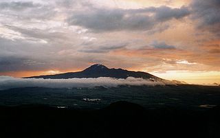
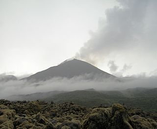
Tungurahua, is an active stratovolcano located in the Cordillera Oriental of Ecuador. The volcano gives its name to the province of Tungurahua. Volcanic activity restarted on August 19, 1999, and is ongoing as of 2013, with several major eruptions since then, the last starting on 1 February 2014.

Illiniza mountain

The Illinizas are a pair of volcanic mountains that are located to the south of Quito, Ecuador. They are located in the Illinizas Ecological Reserve. These twin mountains are separated by a saddle that is about a kilometer long. The peaks are among the highest in Ecuador, with Illiniza Sur standing slightly taller than Illiniza Norte, its northern counterpart, at 5248 metres and 5126 metres respectively.

Cayambe (volcano) volcano in Ecuador

Cayambe or Volcán Cayambe is a volcano in Ecuador, in the Cordillera Central, a range of the Ecuadorian Andes. It is located in Pichincha Province, some 70 km (43 mi) northeast of Quito. It is the third-highest mountain in Ecuador, at an elevation of 5,790 m (18,996 ft) above sea level.

El Altar

El Altar or Capac Urcu is an extinct volcano on the western side of Sangay National Park in Ecuador, 170 km (110 mi) south of Quito, with a highest point of 5,319 m (17,451 ft). Spaniards named it so because it resembled two nuns and four friars listening to a bishop around a church altar. In older English sources it is also called The Altar.

Corazón (volcano) inactive stratovolcano of Ecuador

Corazón is an inactive eroded stratovolcano of Ecuador, situated about 30 km southwest of Quito in the western slopes of the Andes.

Rumiñawi (volcano)

Rumiñahui is a dormant, heavily eroded stratovolcano 4,721 metres (15,489 ft) above sea level. Situated in the Andes mountains 40 km south of Quito, Ecuador, it is overshadowed by its famous neighbour Cotopaxi.

Antisana mountain in Ecuador

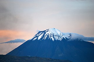
Antisana is a stratovolcano of the northern Andes, in Ecuador. It is the fourth highest volcano in Ecuador, at 5,704 metres (18,714 ft), and is located 50 kilometres (31 mi) SE of the capital city of Quito.

Reventador mountain

Reventador is an active stratovolcano which lies in the eastern Andes of Ecuador. It lies in a remote area of the national park of the same name, which is Spanish for 'exploder' or 'ripper'. Since 1541 it has erupted over 25 times, although its isolated location means that many of its eruptions have gone unreported. Its most recent eruption began in 2008 and is ongoing as of July 4, 2017. The largest historical eruption occurred in 2002. During that eruption the plume from the volcano reached a height of 17 km and pyroclastic flows went up to 7 km from the cone.

Chullachaki legendary devil of the Peruvian and Brazilian Amazonian jungle

The Chullachaki or Chullachaqui, also known as the Shapishico, is a mythical forest creature of the Peruvian and Brazilian Amazonian jungle.

The French Geodesic Mission was an 18th-century expedition to what is now Ecuador carried out for the purpose of measuring the roundness of the Earth and measuring the length of a degree of latitude at the Equator. The mission was one of the first geodesic missions carried out under modern scientific principles, and the first major international scientific expedition.

National Polytechnic School (Ecuador)

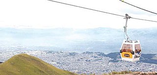
The National Polytechnic University, also known as EPN, is a public university in Quito, Ecuador. The campus, called "José Rubén Orellana", is located at the sector center-oriental of Quito. It occupies an area of 15.2 hectares and has a built area of around 62,000 metres2. Its student body numbers approximately 10,000 of which thirty percent are women. The main campus encompasses ten teaching and research faculties, in addition to four technical and specialized institutes. EPN was founded in 1869 with the aim of becoming the first technical and technological center in the country. Since its beginnings, EPN adopted the polytechnic university model, which stresses laboratory instruction in applied science and engineering. At the campus, there are some libraries with a content primarily oriented to engineering and scientific topics.

Paccha Parish in Azuay Province, Ecuador

Paccha is a town and parish in Cuenca Canton, Azuay Province, Ecuador. The parish covers an area of 25.6 km² and according to the 2001 Ecuadorian census it had a population total of 5,311.

Napu runas or Amazonian Kichwas are a grouping of indigenous Kichwa peoples in the Ecuadorian Amazon, with minor groups across the borders of Colombia and Peru. Amazonian Kichwas consists of two different ethnic peoples, Napu-Kichwa and Canelo-Kichwa. There are approximately 419 organized communities of the Amazonian Kichwas. The basic socio-political unit is the ayllu. The ayllus in turn constitute territorial clans, based on common ancestry. Unlike other subgroups, the Napo Kichwa maintain less ethnic duality of accultured natives or Christians. These groups speak different dialects of Kichwa, such as Bobonaza, Tena and Limoncocha. There are also some groups amongst the Amazonian Kichwa who speak Shuar.

Huasipungo is a 1934 novel by Jorge Icaza (1906-1978) of Ecuador.

Cutimbo

Cutimbo is an archaeological site with stone tombs (chullpa) and cave paintings in Peru.

Mikakucha is a lake in the Napo Province in Ecuador. It is situated in the Antisana Ecological Reserve, southwest of the volcano Antisana.

Aliso, also known as Pan de Azúcar, is a 3,482-metre-high (11,424 ft) volcano in the Ecuadorian Andes on the east of Antisana volcano. The complex contains a semicircular western ridge and lava domes. The volcano has erupted rhyolites and dacites and some andesitic lava flows on a ridge above Baeza. It is covered with tundra and cloud forests. At least two eruptions of Pumayacu occurred during the Holocene; one dated 4400 years ago and another's lapilli deposits overlie a cultural horizon 2000 years old. Older eruptions have been dated at 1.15 ± 0.07 Ma and are of high-potassium types. They compromise typical arc-derived lavas with fractional crystallization and other differentiation processes.

References

  1. 1 2 3 "Guagua Pichincha". Global Volcanism Program . Smithsonian Institution.
  2. 1 2 Rachowiecki, Rob; Wagenhauser, Betsy (1997). Climbing & Hiking in Ecuador (4th ed.). Bradt. p. 91. ISBN   1898323542.
  3. 1 2 Fabián Potosí, C; et al. (2009). Kichwa Yachakukkunapa Shimiyuk Kamu, Runa Shimi - Mishu Shimi, Mishu Shimi - Runa Shimi (Kichwa-Spanish dictionary). Quito: Ministerio de Educación del Ecuador.CS1 maint: Explicit use of et al. (link)
  4. Hall, Minard (1977). El Volcanismo en el Ecuador (in Spanish). Sección Nacional del Ecuador.
  5. Kington, John A. (2010). Climate and Weather. London: Harper Collins. ISBN   9780007185016.
  6. "Guagua Pichincha Volcano". Volcano Discovery. Retrieved 2018-04-19.
  7. "Guagua Pichincha Volcano". Volcano Live. Retrieved 2018-04-19.
  8. Ulloa, Antonio de (1806). A voyage to South America: describing at large the Spanish cities, towns, provinces, &c. on that extensive continent. John Stockdale, R. Faulder, Longman, Lackington and J. Harding. p. 214. Retrieved November 9, 2017.
  9. Ferreiro, Larrie (2011). Measure of the Earth: The Enlightenment Expedition that Reshaped Our World. Basic Books. p. 215.