Pier 42, East River

Last updated
Pier 42 in 1974 SHIPPING PIERS OF BROOKLYN, NEW YORK, WITH MANHATTAN IN THE BACKGROUND. THE NEW YORK, NEW JERSEY METROPOLITAN REGION... - NARA - 555726.jpg
Pier 42 in 1974

Pier 42 is a pier in the Lower East Side of Manhattan, New York City. It was the last working cargo pier on the Manhattan shore of the East River, operating from 1963 to 1987. Since the early 2010s, plans have been underway to turn Pier 42 into a park.

Lower East Side Neighborhood of Manhattan in New York City

The Lower East Side, sometimes abbreviated as LES, is a neighborhood in the southeastern part of the New York City borough of Manhattan, roughly located between the Bowery and the East River, and Canal Street and Houston Street. Traditionally an immigrant, working class neighborhood, it began rapid gentrification in the mid-2000s, prompting the National Trust for Historic Preservation to place the neighborhood on their list of America's Most Endangered Places.

Manhattan Borough in New York City and county in New York, United States

Manhattan, often referred to locally as the City, is the most densely populated of the five boroughs of New York City and its economic and administrative center, cultural identifier, and historical birthplace. The borough is coextensive with New York County, one of the original counties of the U.S. state of New York. The borough consists mostly of Manhattan Island, bounded by the Hudson, East, and Harlem rivers; several small adjacent islands; and Marble Hill, a small neighborhood now on the U.S. mainland, physically connected to the Bronx and separated from the rest of Manhattan by the Harlem River. Manhattan Island is divided into three informally bounded components, each aligned with the borough's long axis: Lower, Midtown, and Upper Manhattan.

New York City Largest city in the United States

The City of New York, usually called either New York City (NYC) or simply New York (NY), is the most populous city in the United States. With an estimated 2018 population of 8,398,748 distributed over a land area of about 302.6 square miles (784 km2), New York is also the most densely populated major city in the United States. Located at the southern tip of the state of New York, the city is the center of the New York metropolitan area, the largest metropolitan area in the world by urban landmass and one of the world's most populous megacities, with an estimated 19,979,477 people in its 2018 Metropolitan Statistical Area and 22,679,948 residents in its Combined Statistical Area. A global power city, New York City has been described as the cultural, financial, and media capital of the world, and exerts a significant impact upon commerce, entertainment, research, technology, education, politics, tourism, art, fashion, and sports. The city's fast pace has inspired the term New York minute. Home to the headquarters of the United Nations, New York is an important center for international diplomacy.

Contents

History

In the mid-19th century, sea trade in New York shifted to the deeper channels of the Hudson River, and the streets along the East River shore were developed with factories, and later with tenements housing various immigrant communities. The waterfront block of South Street opposite Pier 42 lingered on as an industrial area for a few more decades. [1] [2] [3]

Hudson River river in New York State, draining into the Atlantic at New York City

The Hudson River is a 315-mile (507 km) river that flows from north to south primarily through eastern New York in the United States. The river originates in the Adirondack Mountains of Upstate New York, flows southward through the Hudson Valley to the Upper New York Bay between New York City and Jersey City. It eventually drains into the Atlantic Ocean at New York Harbor. The river serves as a political boundary between the states of New Jersey and New York at its southern end. Further north, it marks local boundaries between several New York counties. The lower half of the river is a tidal estuary, deeper than the body of water into which it flows, occupying the Hudson Fjord, an inlet which formed during the most recent period of North American glaciation, estimated at 26,000 to 13,300 years ago. Tidal waters influence the Hudson's flow from as far north as the city of Troy.

The pier was constructed in 1963 as a newsprint terminal. At the time, a fifth of all ocean-borne goods arriving in the United States came by ship to New York. At Pier 42, an estimated 935 million bananas arrived every year from Ecuador. It received its last shipment, a load of bananas, in November 1987. The high cost of labor and transportation, as well as the residential development of the shoreline neighborhoods spelled an end to Manhattan’s role as an international port of trade. [4]

Ecuador Republic in South America

Ecuador, officially the Republic of Ecuador, is a country in northwestern South America, bordered by Colombia on the north, Peru on the east and south, and the Pacific Ocean on the west. Ecuador also includes the Galápagos Islands in the Pacific, about 1,000 kilometres (620 mi) west of the mainland. The capital city is Quito, which is also the largest city.

Park conversion

With the pier’s closing, it sat unused for nearly two decades while the shore on either side was redeveloped as a series of linear parks comprising the Manhattan Waterfront Greenway, which nearly circumnavigates the urban island. Following the September 11, 2001 attacks at the World Trade Center, federal and state funding became available for park expansion projects as part of the revitalization of lower Manhattan. [5] The heavy storm surge that flooded the neighborhood during Hurricane Sandy in October 2012 inspired community advocates to demand a design that would make Pier 42 a park with a function, serving as a soft storm barrier. [6]

Manhattan Waterfront Greenway

The Manhattan Waterfront Greenway is a foreshoreway for walking or cycling, 32 miles (51 km) long, around the island of Manhattan, in New York City. The largest portions are operated by the New York City Department of Parks and Recreation. It is separated from motor traffic, and many sections also separate pedestrians from cyclists. There are three principal parts — the East, Harlem and Hudson River Greenways.

September 11 attacks Attacks against the United States on September 11, 2001

The September 11 attacks were a series of four coordinated terrorist attacks by the Islamic terrorist group al-Qaeda against the United States on the morning of Tuesday, September 11, 2001. The attacks killed 2,996 people, injured over 6,000 others, and caused at least $10 billion in infrastructure and property damage. Additional people died of 9/11-related cancer and respiratory diseases in the months and years following the attacks.

World Trade Center (1973–2001) complex of buildings in Lower Manhattan, New York City, United States

The original World Trade Center was a large complex of seven buildings in Lower Manhattan, New York City, United States. It opened on April 4, 1973, and was destroyed in 2001 during the September 11 attacks. At the time of their completion, the Twin Towers — the original 1 World Trade Center, at 1,368 feet (417 m); and 2 World Trade Center, at 1,362 feet (415.1 m)—were the tallest buildings in the world. Other buildings in the complex included the Marriott World Trade Center, 4 WTC, 5 WTC, 6 WTC, and 7 WTC. The complex was located in New York City's Financial District and contained 13,400,000 square feet (1,240,000 m2) of office space.

During Pier 42’s design phase the temporary project Paths to Pier 42 brought neighborhood residents, artists, designers and community organizations together to activate this park space with collaborative installations and public events to create more accessible green, open space on the waterfront. [7]

Mathews Nielsen Landscape Architects is working on the design of this eight-acre waterfront park on Pier 42, with an emphasis on providing passive recreation space, soft barriers to storm surges, marine habitat, and ecological education opportunities. In deference to the park’s industrial past, a portion of the storage structure’s frame will be retained and used as a pavilion. [8] The first space within the park, in the upland section, is scheduled to open in 2021. [9]

See also

Related Research Articles

North River (Hudson River) portion of the Hudson River near New York City

North River is an alternative name for the southernmost portion of the Hudson River in the vicinity of New York City and northeastern New Jersey in the United States. The entire watercourse was known as the North River by the Dutch in the early seventeenth century; the term fell out of general use for most of the river's 300+ mile course during the early 1900s. However the name remains in very limited use as an artifact among history-inclined local mariners and others and on some nautical charts and maps. The term is also used for infrastructure on and under the river, such as the North River piers, North River Tunnels, and the North River Wastewater Treatment Plant.

East River Park park in the Lower East Side of New York City

East River Park, also called John V. Lindsay East River Park, is 57.5-acre (20 ha) public park located on the Lower East Side of Manhattan, part of the New York City Department of Parks and Recreation. The park stretches along the East River from Montgomery Street up to 12th Street on the east side of the FDR Drive. The southern entrance boasts good views of the Manhattan Bridge and Brooklyn Bridge. The amphitheater, built in 1941 just south of Grand Street, has been reconstructed and is often used for public performances. The park includes football, baseball and soccer fields, tennis, basketball and handball courts, a running track and bike paths including the East River Greenway. Fishing is another popular activity. The park is bisected by the Williamsburg Bridge.

Carl Schurz Park

Carl Schurz Park is a 14.9-acre (6.0 ha) public park in the Yorkville neighborhood of Manhattan, New York City, named for German-born Secretary of the Interior Carl Schurz in 1910, at the edge of what was then the solidly German-American community of Yorkville. The park contains Gracie Mansion, the official residence of the Mayor of New York.

Chelsea Piers architectural structure

Chelsea Piers is a series of piers in Chelsea, on the West Side of Manhattan in New York City. Located to the west of the West Side Highway and Hudson River Park and to the east of the Hudson River, they were originally a passenger ship terminal in the early 1900s that was used by the RMS Lusitania and was the destination of the RMS Titanic. The piers replaced a hodgepodge of run-down waterfront structures with a row of grand buildings embellished with pink granite facades.

Exchange Place (Jersey City) Neighborhood of Jersey City in New Jersey, United States

Exchange Place is a district of Downtown Jersey City, New Jersey, United States, that is sometimes referred to as "Wall Street West" due to the concentration of financial companies that have offices there. The namesake is a square, about 200 feet long, at the foot of Montgomery Street at the Hudson River. This square was created by landfilling the shore at Paulus Hook, and has been a major transportation hub since the colonial era.

Hudson River Park

Hudson River Park is a waterside park on the North River, and is the part of the Manhattan Waterfront Greenway that extends from 59th Street south to Battery Park in the New York City borough of Manhattan. It is a joint state and city collaboration, but is organized as a New York State public-benefit corporation. It is a 550-acre (2.2 km2) park stretching 4.5 miles (7.2 km), making it the second-biggest park in Manhattan after Central Park. The park arose as part of the West Side Highway replacement project in the wake of the abandoned Westway plan.

Flushing Bay bay in New York, United States

Flushing Bay is a tidal embayment in New York City. It is located on the south side of the East River and stretches to the south near the neighborhood of Flushing, Queens. It is bordered on the west by LaGuardia Airport and the Grand Central Parkway, on the south by Northern Boulevard, and on the east by the neighborhood of College Point. The Flushing River empties into the bay at its southeast corner. A 150-foot-wide navigational channel (46 m) dredged at a depth of 14 feet (4.3 m) runs along much of the bay's length.

Brooklyn Bridge Park

Brooklyn Bridge Park is an 85-acre (34 ha) park on the Brooklyn side of the East River in New York City. Designed by landscape architecture firm Michael Van Valkenburgh Associates, the park has revitalized 1.3-mile (2.1 km) of Brooklyn's post-industrial waterfront from Atlantic Avenue in the south, under the Brooklyn Heights Promenade and past the Brooklyn Bridge, to Jay Street north of the Manhattan Bridge. The site includes Brooklyn Piers 1–6, the historic Fulton Ferry Landing, and the preexisting Empire–Fulton Ferry and Main Street Parks. Two Civil War-era structures, Empire Stores and the Tobacco Warehouse, will also be integrated into the park. The park is part of the Brooklyn Waterfront Greenway, a series of parks and bike paths around Brooklyn.

Hudson River Waterfront Walkway

The Hudson River Waterfront Walkway, also known as the Hudson River Walkway, is an ongoing and incomplete project located on Kill van Kull and the western shore of Upper New York Bay and the Hudson River, implemented as part of a New Jersey state-mandated master plan to connect the municipalities from the Bayonne Bridge to the George Washington Bridge with an urban linear park and provide contiguous unhindered access to the water's edge.

East Side (Manhattan) area of Manhattan Island

The East Side of Manhattan refers to the side of Manhattan which abuts the East River and faces Brooklyn and Queens. Fifth Avenue, Central Park from 59th to 110th Streets, and Broadway below 8th Street separate it from the West Side.

The West Side of Manhattan refers to the side of Manhattan Island which abuts the Hudson River and faces New Jersey. Fifth Avenue, Central Park, and lower Broadway separate it from the East Side. The major neighborhoods on the West Side are West Harlem, Morningside Heights, Manhattan Valley, Upper West Side, Hell's Kitchen, Chelsea, West Village, SoHo, and Tribeca. The 8th Avenue and West Side subway lines connect all parts of the West Side. The main north-south roads servicing the West Side are the Henry Hudson Parkway in the north, and the West Side Highway in the south. The Hudson River Greenway separates them from the west shore of the island.

DeWitt Clinton Park park in New York City

DeWitt Clinton Park is a 5.8-acre (23,000 m2) New York City public park in the Hell's Kitchen neighborhood of Manhattan, New York City, between West 52nd and West 54th Streets, and Eleventh and Twelfth Avenues.

Weehawken Port Imperial

Weehawken Port Imperial is an intermodal transit hub on the Weehawken, New Jersey waterfront of the Hudson River across from Midtown Manhattan, served by New York Waterway ferries and buses, Hudson–Bergen Light Rail, and NJT buses. The district lies under and at the foot of Pershing Road, a thoroughfare which travels along the face of the Hudson Palisades, which rise to its west. The Hudson River Waterfront Walkway runs along the shoreline and is abutted by recently constructed residential neighborhoods, Lincoln Harbor to the south and Bulls Ferry to the north.

West Midtown Ferry Terminal

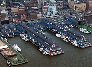
The West Midtown Ferry Terminal is a passenger bus and ferry terminal serving ferries along the Hudson River in New York City and northeastern New Jersey. It is located at Piers 78 and 79 in Hudson River Park adjacent to the West Side Highway at West 39th Street in Midtown Manhattan. The municipally-owned facility opened in 2005 as multi-user terminal to accommodate an increasing demand for ferry service in the Port of New York and New Jersey and to provide ferry slips for short haul crossings, water taxis, and high-speed long distance service. Built largely with public funds the West Midtown became upon its opening one of the principal terminals used by the private NY Waterway-operated routes to Jersey City, Hoboken, Weehawken, and Edgewater.

Sunset Park Greenway

The Sunset Park Greenway (SPGW) or Shore Parkway Greenway Connector is a 4.41 mile (7.10 km) long, signed cycle route traversing Sunset Park, Brooklyn with portions running through the adjacent neighborhoods of Bay Ridge, Borough Park and Kensington.

Robert Moses Playground

Robert Moses Playground is a 1.3-acre (0.53 ha) playground and park in the New York City borough of Manhattan. It is located in the Murray Hill neighborhood on First Avenue between 41st and 42nd streets, immediately south of the United Nations Headquarters. The park is named for New York's "master builder" Robert Moses.

East River Greenway

The East River Greenway is an approximately 9.44-mile-long (15.19 km) foreshoreway for walking or cycling on the east side of the island of Manhattan on the East River. It is part of the Manhattan Waterfront Greenway. The largest portions are operated by the New York City Department of Parks and Recreation. It is separated from motor traffic, and many sections also separate pedestrians from cyclists. The greenway is parallel to the Franklin D. Roosevelt East River Drive for a majority of its length.

Bridge Park (Bronx)

Bridge Park is a park in the Bronx, New York, created as part of a larger vision of creating connected waterfront parks along both sides of the Harlem River. The park’s name references three large arch bridges linking Manhattan and the Bronx: Alexander Hamilton Bridge, Washington Bridge, and High Bridge.

Barretto Point Park Public park in New York City


Barretto Point Park is a waterfront public park on the East River located in the Hunts Point neighborhood of the Bronx. Its namesake is Francis J. Barretto, a 19th-century merchant and State Assemblyman who lived in the area.

References

  1. (1903) [ Lower East Side, Little Italy, SoHo, Tribeca ] Sanborn Map Company, Atlas 108. Vol. 1
  2. (1916) [ Manhattan ] Bromley, G.W., Atlas of the borough of Manhattan, Desk Ed.
  3. (1955) [ Manhattan ] Bromley, G.W., Manhattan land book of the city of New York
  4. Roberts, Sam (1987-10-19). "METRO MATTERS; Death of a Ritual: Working the Last Of Pier 42's Cargo". The New York Times. ISSN   0362-4331 . Retrieved 2019-06-03.
  5. "Day-O! Squadron and Schumer Go Bananas for Pier 42". Observer. 2012-10-01. Retrieved 2019-06-03.
  6. Brightman, Terrie "Making the Past Present: How a Site’s History Can Shape its Future" Metropolis Magazine March 26, 2014 http://www.metropolismag.com/Making-the-Past-Present-How-a-Site's-History-Can-Shape-Its-Future/
  7. Paths to Pier 42 "About Paths to Pier 42" https://pathstopier42.com/about-2/
  8. Mathews Nielsen Landscape Architects "Pier 42" http://www.mnlandscape.com/project_page.php?cat_id=3&pr_id=184
  9. "City Plans Playground, Turf Upgrades On Manhattan's East Side". East Village, NY Patch. 2019-05-23. Retrieved 2019-06-03.

Coordinates: 40°42′37″N73°58′55″W / 40.71028°N 73.98194°W / 40.71028; -73.98194