Richmond Hill, New Zealand

Last updated

Richmond Hill
Richmond Hill, New Zealand
Coordinates: 43°34′23″S172°45′18″E / 43.573°S 172.755°E / -43.573; 172.755
CountryNew Zealand
City Christchurch
Local authority Christchurch City Council
Electoral wardHeathcote
Area
[1]
  Land88 ha (217 acres)
Population
 (2018 Census) [2]
  Total390
(Avon Heathcote Estuary)
Clifton
Pfeil oben.svg
Pfeil links.svgRichmond HillPfeil rechts.svg
Pfeil unten.svg
Sumner
Port Hills

Richmond Hill is a hillside suburb above Sumner in Christchurch, New Zealand.

Contents

Two small buildings in Sumner, one of which belonged to Dobson and was located in Nayland Street (pencil sketch, 1865) Edward Dobson's house, Sumner, 1865.jpg
Two small buildings in Sumner, one of which belonged to Dobson and was located in Nayland Street (pencil sketch, 1865)

Richmond Hill is a volcanic spur extending from Tauhinukorokio / Mount Pleasant. [3] The first European owner was Edward Dobson, who had a cottage in Nayland Street and whose 50 acres (20 ha) ran up the hill. Dobson kept 2 acres (0.81 ha) around his house and sold the remainder of his land to George Day. Upon Day's death, the land passed to his daughter, who sold it to the Morton brothers (Arthur and R. M. D.), and who in turn sold it to George Humphreys. The latter subdivided the land and had a road up the hill built by 1909. [3] Walter de Thier managed Humphreys' farm on the hill and his favourite song was "The Lass of Richmond Hill", and with Humphreys' consent, the property was called Richmond Hill. [4]

Humphreys was a leading businessman who lived at Daresbury in Fendalton. [3] He was also a member of the Christchurch Golf Club and took pity of a group of men who regularly met in Sumner on an empty section for an improvised game of golf using hockey sticks, tennis balls, and tin cans sank into the ground as holes. He offered them 40 acres (16 ha) of his undulating land, on which the 12-hole Richmond Hill Golf Course opened in April 1910. [5]

Due to the steepness of the road up from Nayland Street, the subdivision was slow to develop. There were just ten houses on Richmond Hill by 1930, and activity only picked up after the end of World War II. One of the early residents included the architect Cecil Wood. [5] The golf course closed in December 1997 and some of the land was further subdivided. [6]

Demographics

Richmond Hill is part of the Clifton Hill SA2 statistical area. [7]

Historical population
YearPop.±% p.a.
2006333    
2013267−3.11%
2018390+7.87%
Source: [2]

Richmond Hill, corresponding to the SA1 statistical area of 7026578, covers 0.88 km2 (0.34 sq mi). [1] It had a population of 390 at the 2018 New Zealand census, an increase of 123 people (46.1%) since the 2013 census, and an increase of 57 people (17.1%) since the 2006 census. There were 135 households. There were 195 males and 198 females, giving a sex ratio of 0.98 males per female. The median age was 44.5 years (compared with 37.4 years nationally), with 81 people (20.8%) aged under 15 years, 51 (13.1%) aged 15 to 29, 216 (55.4%) aged 30 to 64, and 45 (11.5%) aged 65 or older.

Ethnicities were 95.4% European/Pākehā, 1.5% Māori, 0.0% Pacific peoples, 3.8% Asian, and 1.5% other ethnicities (totals add to more than 100% since people could identify with multiple ethnicities).

Although some people objected to giving their religion, 57.7% had no religion, 33.1% were Christian, 0.8% were Buddhist and 0.8% had other religions.

Of those at least 15 years old, 132 (42.7%) people had a bachelor or higher degree, and 24 (7.8%) people had no formal qualifications. The median income was $53,900, compared with $31,800 nationally. The employment status of those at least 15 was that 183 (59.2%) people were employed full-time, 57 (18.4%) were part-time, and 9 (2.9%) were unemployed. [2]

Notes

  1. 1 2 "ArcGIS Web Application". statsnz.maps.arcgis.com. Retrieved 11 October 2021.
  2. 1 2 3 "Statistical area 1 dataset for 2018 Census". Statistics New Zealand. March 2020. 7026578.
  3. 1 2 3 Ogilvie 2009, p. 56.
  4. Harper, Margaret (20 February 2014). "Christchurch Place Names: N - Z" (PDF). Christchurch City Libraries. p. 42. Retrieved 1 March 2014.
  5. 1 2 Ogilvie 2009, p. 57.
  6. Ogilvie 2009, p. 58.
  7. 2018 Census place summary: Clifton Hill

Related Research Articles

<span class="mw-page-title-main">Banks Peninsula</span> Peninsula south of Christchurch, New Zealand

<span class="mw-page-title-main">Sumner, New Zealand</span> Suburb in Christchurch, New Zealand

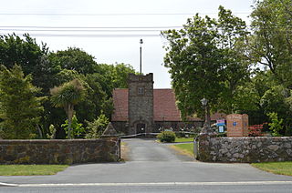
Sumner is a coastal seaside suburb of Christchurch, New Zealand and was surveyed and named in 1849 in honour of John Bird Sumner, the then newly appointed Archbishop of Canterbury and president of the Canterbury Association. Originally a separate borough, it was amalgamated with the city of Christchurch as communications improved and the economies of scale made small town boroughs uneconomic to operate.

<span class="mw-page-title-main">Port Hills</span> Range of hills of Canterbury, New Zealand

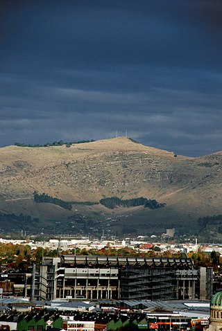
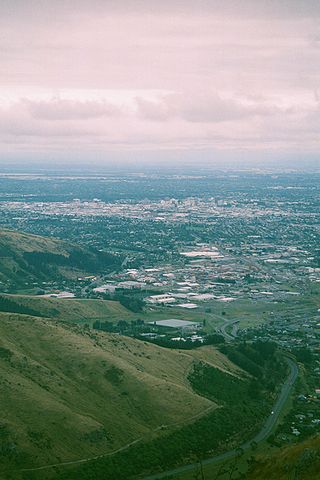
The Port Hills are a range of hills in Canterbury Region of New Zealand, so named because they lie between the city of Christchurch and its port at Lyttelton. They are an eroded remnant of the Lyttelton volcano, which erupted millions of years ago.

<span class="mw-page-title-main">Amberley, New Zealand</span> Town in Canterbury, New Zealand

Amberley is a town located in the Hurunui District in north Canterbury, on the east coast of the South Island of New Zealand. It is located on State Highway 1 approximately 50 km north of Christchurch. It is the seat of the Hurunui District Council. The nearest town to the north of Amberly via state highway one is Waipara (11 km) and the nearest town to the south is Leithfield (5.7 km).

<span class="mw-page-title-main">Dobson, New Zealand</span> Place in West Coast, New Zealand

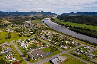
Dobson is a small town on the banks of the Grey River in the South Island of New Zealand. It is 10 kilometres (6 mi) east from the river's mouth at Greymouth. The settlement of Taylorville is across the river from Dobson, but no bridge directly connects the two. State Highway 7 passes through Dobson.

<span class="mw-page-title-main">Stoke, New Zealand</span> Suburb in Nelson, Nelson, New Zealand

Stoke is a suburb of Nelson in New Zealand, located between Richmond and Tāhunanui. Stoke was named by William Songer, the personal servant of Arthur Wakefield, after his birthplace Stoke-by-Nayland in Suffolk.

<span class="mw-page-title-main">Redcliffs</span> Suburb in Christchurch, New Zealand

Redcliffs is an outer coastal suburb of Christchurch, Canterbury, New Zealand.

<span class="mw-page-title-main">Richmond, Christchurch</span> Suburb in Christchurch, New Zealand

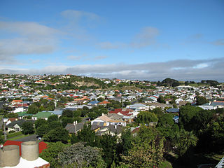
Richmond is a minor suburb of Christchurch, New Zealand.

<span class="mw-page-title-main">Mount Pleasant, New Zealand</span> Suburb in Christchurch, New Zealand

Mount Pleasant (Tauhinukorokio) is a coastal suburb of Christchurch, New Zealand. The suburb is located on the northern flank of the mountain Tauhinukorokio/Mount Pleasant in the Port Hills. It takes its name from the English version of the mountain's name.

<span class="mw-page-title-main">Tainui, New Zealand</span> Suburb in Dunedin, New Zealand

Tahuna and Tainui are two small, somewhat vaguely defined suburbs of the New Zealand city of Dunedin. They lie to the south of Andersons Bay and Musselburgh, close to Dunedin's southern coastline. Both are often considered parts of either Musselburgh or Andersons Bay.

<span class="mw-page-title-main">Parklands, New Zealand</span> Suburb in Christchurch, New Zealand

Parklands is a suburb of Christchurch, New Zealand. It is located north east of the city centre near Bottle Lake Forest.

<span class="mw-page-title-main">Tauhinukorokio / Mount Pleasant</span>

Tauhinukorokio / Mount Pleasant, also known just as either Mount Pleasant or Tauhinukorokio individually, is the highest elevation in the eastern Port Hills in Christchurch, New Zealand. It once held a Māori pā, but there was little left of it when European settlers first arrived in the 1840s. The hill was first used as a sheep run, and became the base trig station for the survey of Canterbury. It was also used as a signal station to make residents aware of ships coming into Lyttelton Harbour / Whakaraupō. During World War II, an extensive heavy anti-aircraft artillery (HAA) battery was built near the summit, and the foundations of those buildings still exist.

<span class="mw-page-title-main">Tai Tapu</span> Place in South Island, New Zealand

Tai Tapu, previously known as Taitapu, is a small town adjacent to the Halswell River and nestled in the Port Hills, located 6 km east of the town of Lincoln and 18 km south west of Christchurch in the Canterbury region of New Zealand's South Island. State Highway 75 passes through the centre of the village, connecting Christchurch with Akaroa and the Banks Peninsula.

Clifton is a hillside suburb above Sumner in Christchurch, New Zealand.

<span class="mw-page-title-main">Hillsborough, Christchurch</span> Suburb in Christchurch, New Zealand

Hillsborough is a mixed industrial and residential suburb of Christchurch, New Zealand, located approximately 4 kilometres (2.5 mi) to the south-east of the city centre.

<span class="mw-page-title-main">Kennedys Bush</span> Suburb in Christchurch, New Zealand

Kennedys Bush is a south-western suburb of Christchurch, New Zealand.

<span class="mw-page-title-main">Moncks Bay</span> Suburb in Christchurch, New Zealand

Moncks Bay is a south-eastern suburb of Christchurch, New Zealand.

<span class="mw-page-title-main">Scarborough, New Zealand</span> Suburb in Christchurch, New Zealand

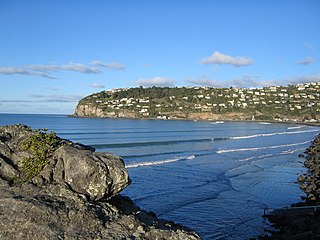
Scarborough is a hillside suburb above Sumner in Christchurch, New Zealand.

St Andrews Hill is a hillside suburb in south-east Christchurch, New Zealand.

Best Island is an island in the southernmost part of Tasman Bay / Te Tai-o-Aorere, on the northern coast of New Zealand's South Island. The island runs northwest to southeast for 3.7 kilometres (2.3 mi). It is connected to the South Island on the southwest and to Bell Island to the northeast by causeways. It is in the Richmond Ward of Tasman District.

References