Vimy Peak

Last updated
Vimy Peak
Summer Day in Waterton.jpg
Vimy Peak
Highest point
Elevation 2,385 m (7,825 ft) [1]
Prominence 190 m (620 ft) [1]
Parent peak Arras Peak (2423 m) [1]
Listing Mountains of Alberta
Coordinates 49°02′18″N113°51′29″W / 49.03833°N 113.85806°W / 49.03833; -113.85806 Coordinates: 49°02′18″N113°51′29″W / 49.03833°N 113.85806°W / 49.03833; -113.85806 [2]
Geography
Canada Alberta relief location map - transverse mercator proj.svg
Red triangle with thick white border.svg
Vimy Peak
Location of Vimy Peak in Alberta
Canada relief map 2.svg
Red triangle with thick white border.svg
Vimy Peak
Vimy Peak (Canada)
Location Alberta, Canada
Parent range Canadian Rockies
Topo map NTS 82H4 Waterton Lakes [2]
Geology
Age of rock Cambrian
Climbing
Easiest route Hiking trail [3]

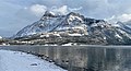
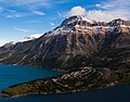
Vimy Peak is a 2,385- metre (7,825- foot ) summit located in Waterton Lakes National Park, in the Canadian Rockies of Alberta, Canada. It is set along the east shore of Waterton Lake on the opposite side from Waterton Park townsite. It is situated 5.4 km (3.4 mi) west of Sofa Mountain, and the nearest higher neighbor is Arras Peak, 3.1 km (1.9 mi) to the southeast. [1] Vimy Peak anchors the northern end of Vimy Ridge, which stretches three kilometers to Arras Peak anchoring the southern end.

Contents

History

The mountain was originally labelled as Sheep Mountain on George Dawson's 1886 map. [1] Kootenay Brown referred to it as Goat Mountain. [4] However, in 1917 it was renamed in honor of the Canadian Army's victory at the Battle of Vimy Ridge, to commemorate all who survived and died in the World War I battle. [5] This mountain's name was officially adopted in 1943 by the Geographical Names Board of Canada. [2]

Geology

Like other mountains in Waterton Lakes National Park, Vimy Peak is composed of sedimentary rock laid down during the Precambrian to Jurassic periods. Formed in shallow seas, this sedimentary rock was pushed east and over the top of younger Cretaceous period rock during the Laramide orogeny. [6]

Climate

Based on the Köppen climate classification, Vimy Peak is located in a subarctic climate with cold, snowy winters, and mild summers. [7] Temperatures can drop below −20 °C with wind chill factors below −30 °C. Precipitation runoff from Vimy Peak drains into Waterton Lake, thence Waterton River.

See also

Related Research Articles

<span class="mw-page-title-main">Mount Galwey</span> Mountain in Waterton Lakes NP, Alberta, Canada

Mount Galwey is a mountain located north of Blakiston Creek in Waterton Lakes National Park, Alberta, Canada. The mountain was named in 1934 after Lt. Galwey, who was an astronomer for the International Boundary Commission.

<span class="mw-page-title-main">Mount Blakiston</span>

Mount Blakiston is a mountain in the southwestern corner of Alberta, Canada and the highest point within Waterton Lakes National Park. The mountain is situated in the Clark Range, north of Lineham Creek and south of Blakiston Creek. Blakiston's closest neighbours include Mount Hawkins 2,685 m (8,809 ft) directly to the west along a connecting ridge and Mount Lineham 2,728 m (8,950 ft) to the south.

<span class="mw-page-title-main">Wenkchemna Peak</span> Mountain peak in Canada

Wenkchemna Peak is located on the border of Alberta and British Columbia. It was named in 1894 by Samuel E. S. Allen.

<span class="mw-page-title-main">Forum Peak</span>

Forum Peak is a summit located on the border of Alberta and British Columbia on the Continental Divide. It is the southernmost mountain in the Canadian Rockies, situated only 500 metres north of the Canada–United States border. It was named after Forum Lake below the mountain. It is visible from the end of Highway 5 at Cameron Lake, which is within Waterton Lakes National Park, and the mountain is on the park's southwest border.

<span class="mw-page-title-main">Mount Alderson</span> Mountain in Waterton Lakes NP, Alberta, Canada

Mount Alderson is a 2,692-metre (8,832-foot) summit located in Waterton Lakes National Park, in the Canadian Rockies of Alberta, Canada. Its nearest higher peak is Mount Custer, 8.0 km (5.0 mi) to the southwest. Mount Richards is situated 2.0 km (1.2 mi) to the southeast, and Bertha Peak is to the immediate northeast.

<span class="mw-page-title-main">Mount Boswell</span>

Mount Boswell is a 2,454-metre (8,051-foot) summit located in Waterton Lakes National Park, in the Canadian Rockies of Alberta, Canada. It is situated along the east shore of Waterton Lake, one kilometre north of the Canada–United States border. Its nearest higher peak is Miche Wabun Peak, 5.0 km (3.1 mi) to the southeast.

<span class="mw-page-title-main">Mount Crandell</span>


Mount Crandell is a 2,381-metre (7,812-foot) mountain summit located in Waterton Lakes National Park, in the Canadian Rockies of Alberta, Canada. It is situated immediately north of the Waterton townsite. Its nearest higher peak is Bertha Peak, 2.94 km (1.83 mi) to the south-southwest.

<span class="mw-page-title-main">Mount Dungarvan</span>

Mount Dungarvan is a 2,575-metre (8,448-foot) mountain summit located in Waterton Lakes National Park, in the Canadian Rockies of Alberta, Canada. Its nearest higher peak is Cloudy Peak, 2.8 km (1.7 mi) to the west.

<span class="mw-page-title-main">Mount Invincible</span> Mountain in Alberta, Canada

Mount Invincible is a 2,700-metre (8,900-foot) mountain summit located in Peter Lougheed Provincial Park in the Canadian Rockies of Alberta, Canada. The peak is visible from Alberta Highway 40, and the Upper and Lower Kananaskis Lakes area. Mount Invincible's nearest higher peak is Mount Warspite, 2.6 km (1.6 mi) to the northwest.

<span class="mw-page-title-main">Mount Richards</span> Mountain in Waterton Lakes NP, Alberta, Canada

Mount Richards is a 2,377-meter-elevation (7,799-foot) mountain summit located in Waterton Lakes National Park, in the Canadian Rockies of Alberta, Canada. It is situated just north of the Canada–United States border, with the south footing of the mountain at Boundary Creek just within Glacier National Park of the United States. Its nearest higher peak is Mount Alderson, 2.0 km (1.2 mi) to the northwest. Bertha Lake and Bertha Peak are situated immediately to the north.

<span class="mw-page-title-main">Ribbon Peak</span> Summit in the Canadian Rockies

Ribbon Peak is a 2,880-metre (9,450-foot) summit located in Kananaskis Country in the Canadian Rockies of Alberta, Canada. Ribbon's nearest higher peak is Mount Bogart, 1.0 km (0.62 mi) to the southwest. Ribbon Peak is situated four kilometres northwest of Mount Kidd, and both can be seen from Highway 40 near the Kananaskis Village junction along Highway 40.

<span class="mw-page-title-main">Mount Indefatigable</span> Mountain in Alberta, Canada

Mount Indefatigable is a 2,667-metre (8,750-foot) mountain summit located in Peter Lougheed Provincial Park in the Canadian Rockies of Alberta, Canada. The peak is visible from Alberta Highway 40, and the Kananaskis Lakes area. Mount Indefatigable's nearest higher neighbor is Mount Invincible, 1.8 km (1.1 mi) to the northwest.

<span class="mw-page-title-main">Wasootch Peak</span>

Wasootch Peak is a 2,352-metre (7,717-foot) mountain summit located in the Fisher Range of Kananaskis Country in the Canadian Rockies of Alberta, Canada. The peak is situated on the northern end of the ridge that separates Wasootch Creek from the Kananaskis River. Wasootch Peak's nearest higher peak is Old Baldy, 1.54 km (0.96 mi) to the southeast. The peak may be seen from Highway 40, and is prominently featured from the ski slopes at Nakiska. Wasootch is from the Stoney language word wazi, which translated means unique.

<span class="mw-page-title-main">Bertha Peak</span>

Bertha Peak is a 2,454-metre (8,051-foot) mountain summit located in Waterton Lakes National Park, in the Canadian Rockies of Alberta, Canada. It is situated behind the Waterton townsite. Its nearest higher peak is Mount Alderson, 2.0 km (1.2 mi) to the southwest. Bertha Lake lies at the southern foot of the peak, with Mount Richards on the opposite side of the lake. Mount Crandell lies to the north.

<span class="mw-page-title-main">Olson Mountain</span> Mountain in Glacier National Park, US

Olson Mountain, also known as Mount Olson, is a 7,913-foot-elevation mountain summit located in the Livingston Range, of Glacier National Park in the U.S. state of Montana. Olson Mountain rises more than 3,700 feet (1,100 m) above the western shore of Waterton Lake. The mountain was named for a surveyor on the International Boundary Survey, with the name officially adopted in 1929. The nearest higher peak is Campbell Mountain, 1.13 miles (1.82 km) to the north, and Citadel Peaks is two miles to the south. Precipitation runoff from the mountain drains into Olson Creek before it empties to Waterton Lake.

<span class="mw-page-title-main">Naiset Point</span>

Naiset Point is a 2,755-metre (9,039-foot) mountain summit located in Mount Assiniboine Provincial Park, in the Canadian Rockies of British Columbia, Canada. The mountain is situated 1.0 km (0.62 mi) southeast of Lake Magog, and at the end of the ridge extending north from Terrapin Mountain. Naiset Point is composed of sedimentary rock laid down during the Cambrian period. Formed in shallow seas, this sedimentary rock was pushed east and over the top of younger rock during the Laramide orogeny.

<span class="mw-page-title-main">Citadel Peaks</span>

Citadel Peaks is a mountain ridge located in the Goat Haunt area of Glacier National Park, in Glacier County of the U.S. state of Montana. This arête with a row of sharp points is part of the Livingston Range, and is approximately four miles east of the Continental Divide. Neighbors include Olson Mountain, two miles (3.2 km) to the north, Mount Cleveland four miles (6.4 km) to the east, and Kootenai Peak 2.7 miles (4.3 km) to the south. Topographic relief is significant as Citadel Peaks rises over 3,800 feet above Waterton Lake in less than two miles, and 3,000 feet above Lake Janet in one mile. Precipitation runoff from the mountain drains to the south end of Waterton Lake. The first ascent of Citadel Spire, a major pinnacle on the ridge, was made in 1967 by Jerry Kanzler, Jim Kanzler, Ray Martin, and Clare Pogreba. This geographical feature's name was officially adopted in 1929 by the United States Board on Geographic Names. To the Pikuni people, Citadel Peaks is known as "Ataniawxis", meaning "The Needles".

<span class="mw-page-title-main">Sofa Mountain</span> Mountain in Waterton Lakes NP, Canada

Sofa Mountain is a 2,515-meter (8,251-foot) summit located in Waterton Lakes National Park, in Alberta, Canada. It is part of the Lewis Range which is a subset of the Canadian Rockies, and is the easternmost mountain in the Canadian Rockies, as well as the park. It is situated 5.4 km (3.4 mi) east of Vimy Peak, and the nearest higher neighbor is Crypt Peak, 4.6 km (2.9 mi) to the southwest. Topographic relief is significant as the north aspect rises over 1,220 meters (4,000 feet) above Middle Waterton Lake in approximately six kilometers.

<span class="mw-page-title-main">Porcupine Ridge</span> Mountain ridge in Montana, US

Porcupine Ridge is a prominent mountain ridge located in the Goat Haunt area of Glacier National Park, in Glacier County of the U.S. state of Montana. This mountain is part of the Livingston Range, and is situated 1.5 mile east of the Continental Divide. Topographic relief is significant as the summit rises approximately 3,900 feet above Lake Frances in one mile, and nearly 5,000 feet above Waterton Lake in five miles. Precipitation runoff from the mountain drains to the Waterton River via Olson and Valentine Creeks. This geographical feature's name was officially adopted in 1911 by the United States Board on Geographic Names.

<span class="mw-page-title-main">Crypt Peak</span> Mountain summit in Glacier National Park

Crypt Peak is an 8,579-foot (2,615 m) mountain summit located in Glacier National Park, in Glacier County of the U.S. state of Montana. It is situated along the Canada–United States border, above Crypt Lake, and is partially within Waterton Lakes National Park. Crypt Peak is part of the Lewis Range, and is approximately three miles east of Waterton Lake. Topographic relief is significant as Crypt Peak rises over 2,100 feet above Crypt Lake in approximately one-half mile (1.6 km), and 4,400 ft (1,340 m) above Waterton Lake in three miles (4.8 km). Precipitation runoff from the mountain drains west to Waterton Lake, and east to Belly River. This geographical feature's name has not yet been officially adopted by the United States Board on Geographic Names.

References

  1. 1 2 3 4 5 "Vimy Peak". Bivouac.com. Retrieved 2018-11-24.
  2. 1 2 3 "Vimy Peak". Geographical Names Data Base . Natural Resources Canada . Retrieved 2018-11-24.
  3. Vimy Peak SummitPost
  4. "Vimy Peak". PeakFinder.com. Retrieved 2019-08-19.
  5. Vimy Place-names of Alberta, page 129
  6. Gadd, Ben (2008). "Geology of the Rocky Mountains and Columbias".{{cite journal}}: Cite journal requires |journal= (help)
  7. Peel, M. C.; Finlayson, B. L.; McMahon, T. A. (2007). "Updated world map of the Köppen−Geiger climate classification". Hydrol. Earth Syst. Sci. 11 (5): 1633–1644. Bibcode:2007HESS...11.1633P. doi: 10.5194/hess-11-1633-2007 . ISSN   1027-5606. S2CID   9654551.