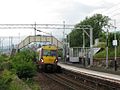
The North Clyde Line platform with the embankment for the West Highland Line behind | |||||
| General information | |||||
| Location | Helensburgh, Argyll and Bute Scotland | ||||
| Coordinates | 55°59′42″N4°42′43″W / 55.9949°N 4.7120°W | ||||
| Grid reference | NS309813 | ||||
| Managed by | ScotRail | ||||
| Transit authority | SPT | ||||
| Platforms | 1 | ||||
| Other information | |||||
| Station code | CGD [2] | ||||
| Fare zone | D4 | ||||
| Key dates | |||||
| 15 May 1882 | Opened | ||||
| Passengers | |||||
| 2019/20 | |||||
| 2020/21 | |||||
| 2021/22 | |||||
| 2022/23 | |||||
| 2023/24 | |||||
| |||||
| |||||

Craigendoran railway station (Scottish Gaelic :Creag an Dòbhrain) is a railway station serving Craigendoran,east of Helensburgh,Scotland. The station is managed by ScotRail,which operates all services at the station. It is located on the North Clyde Line between Helensburgh Central and Cardross,23 miles 18 chains (37.4 km) west of Glasgow Queen Street (High Level),measured via Singer and Maryhill. [3] West Highland Line trains used to call here but no longer do following the closure of the upper platforms.