The Callander and Oban Railway company was established with the intention of linking the sea port of Oban to the railway network. This involved a long line from Callander through wild and thinly populated terrain, and shortage of money meant that the line was opened in stages from 1866 to 1880.

Oban railway station is a railway station serving Oban in Scotland. It is the terminus of one branch of the highly scenic West Highland Line, sited 71 miles 44 chains (115.1 km) from Callander, via Glen Ogle. It was originally the terminus of the Callander and Oban Railway. All services are operated by ScotRail, who also manage the station.

Upper Tyndrum railway station is one of two railway stations serving the small village of Tyndrum in Scotland. It is on the Fort William route of the scenic West Highland Line, between Crianlarich and Bridge of Orchy, sited 41 miles 25 chains (66.5 km) from Craigendoran Junction, near Helensburgh. Services are operated by ScotRail - who manage the station - and Caledonian Sleeper.

Arrochar and Tarbet railway station is a railway station on the West Highland Line in Scotland. It stands between the villages of Arrochar and Tarbet. It is sited 19 miles 45 chains (31.5 km) from Craigendoran Junction, near Helensburgh, between Ardlui and Garelochhead. ScotRail manage the station and operate most services, with others provided by Caledonian Sleeper.
Helensburgh Upper railway station serves the town of Helensburgh, Scotland, on the north shore of the Firth of Clyde to the west of Glasgow. It is located in a residential area uphill from the town centre and is by far the smaller of the town's two stations. It is on the West Highland Line, 2 miles 8 chains (3.4 km) from Craigendoran Junction, near Helensburgh, the first station on the line before Garelochhead. ScotRail manage the station and operate most services, with others provided by Caledonian Sleeper.

Ardlui railway station is a rural railway station, serving Ardlui at the north end of Loch Lomond, in Scotland. The station is located on the West Highland Line, sited 27 miles 43 chains (44.3 km) from Craigendoran Junction, near Helensburgh, between Crianlarich and Arrochar and Tarbet. ScotRail manage the station and operate most services, others provided by Caledonian Sleeper.

Falls of Cruachan railway station is a railway station located at the foot of Ben Cruachan in Scotland. This station is on the Oban branch of the West Highland Line, originally part of the Callander and Oban Railway. It is sited between Taynuilt and Loch Awe, sited 52 miles 69 chains (85.1 km) from Callander via Glen Ogle. ScotRail manage the station and operate all services.

Fearn railway station is a railway station serving the village of Hill of Fearn in the Highland council area of Scotland, located around 1.3 miles (2.1 km) from the village. It is situated on the Far North Line, 40 miles 60 chains (65.6 km) form Inverness, between Tain and Invergordon, and is also the nearest station to Balintore, Hilton and Shandwick, Portmahomack and the Nigg Bay area of Easter Ross. ScotRail, who manage the station, operate all services.
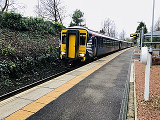
Crianlarich railway station is a railway station serving the village of Crianlarich in Scotland. It is located on the West Highland Line, sited 41 miles 25 chains (66.5 km) from Craigendoran Junction, near Helensburgh, with Ardlui to the south, and Tyndrum Lower and Upper Tyndrum to the north west, on the routes to Oban and Mallaig respectively, which diverge immediately north of the station. ScotRail, who manage the station, operate most services.

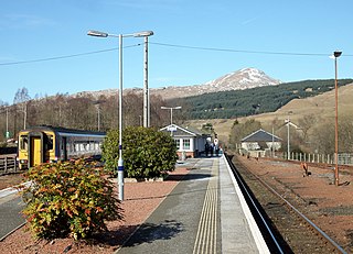
Bridge of Orchy railway station is a railway station in the village of Bridge of Orchy in the west of Scotland. The station is on the West Highland Line, between Rannoch and Upper Tyndrum, 48 miles 68 chains (78.6 km) from Craigendoran Junction, near Helensburgh. ScotRail manage the station and operate most services, with others provided by Caledonian Sleeper.
Tulloch railway station is a rural railway station in the remote Tulloch area of the Highland region of Scotland. This station is on the West Highland Line, between Corrour and Roy Bridge, sited 81 miles 59 chains (131.5 km) from Craigendoran Junction, near Helensburgh.

Garelochhead railway station is a railway station serving the village of Garelochhead, on the Gare Loch, in Scotland. This station is on the West Highland Line and is a boundary station for SPT. It is sited 8 miles 76 chains (14.4 km) from Craigendoran Junction, near Helensburgh, between Arrochar and Tarbet and Helensburgh Upper. ScotRail manage the station and operate most services, with others provided by Caledonian Sleeper.

Dalmally railway station is a railway station serving the village of Dalmally, near Loch Awe in Scotland. This station is on the Oban branch of the West Highland Line, originally part of the Callander and Oban Railway. It is sited 46 miles 76 chains (75.6 km) from Callander via Glen Ogle, between Tyndrum Lower and Loch Awe. ScotRail manage the station and operate all services.

Loch Awe railway station is a railway station serving the village of Lochawe, on the northern bank of Loch Awe, in western Scotland. This station is on the Oban branch of the West Highland Line, originally part of the Callander and Oban Railway. It is sited 49 miles 48 chains (79.8 km) from Callander via Glen Ogle, between Dalmally and Falls of Cruachan. ScotRail manage the station and operate all services.
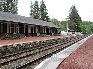
Taynuilt railway station is a railway station serving the village of Taynuilt in western Scotland. This station is on the Oban branch of the West Highland Line, originally part of the Callander and Oban Railway, between Falls of Cruachan and Connel Ferry, sited 58 miles 55 chains (94.4 km) from Callander via Glen Ogle. ScotRail manage the station and operate all services.

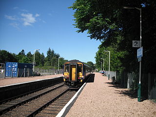
Connel Ferry railway station is a railway station serving the village of Connel in western Scotland. This station is on the Oban branch of the West Highland Line, originally part of the Callander and Oban Railway, between Oban and Taynuilt, sited 65 miles 30 chains (105.2 km) from Callander via Glen Ogle. All services are operated by ScotRail, who also manage the station.
Crianlarich Lower was a railway station located in Crianlarich, Stirling.

Killin Junction was a railway station located in Glen Dochart, Stirling (district) close to where the road from Glen Ogle joins the Crianlarich to Killin road.

Callander was a railway station located in Callander, in the council area of Stirling, Scotland.

Ach-na-Cloich is a closed railway station located on the south shore of Loch Etive, in Argyll and Bute. Its site is located on the Oban route of the scenic West Highland Line, that was part of the Callander and Oban Railway.

