Holland Land Office

Last updated

Holland Land Office
Holland land 8911.jpg
North elevation, 2005
USA New York location map.svg
Red pog.svg
Usa edcp location map.svg
Red pog.svg
Location Batavia, NY
Coordinates 42°59′56″N78°11′26″W / 42.99889°N 78.19056°W / 42.99889; -78.19056
Built1815
Architect Joseph Ellicott
NRHP reference No. 66000521
NYSRHP No.03740.000007
Significant dates
Added to NRHPOctober 15, 1966 [1]
Designated NHLOctober 9, 1960 [2]
Designated NYSRHPJune 23, 1980

The Holland Land Office building is located on West Main Street (New York state routes 5, 33 and 63) in downtown Batavia, New York, United States. It is a stone building designed by surveyor Joseph Ellicott and erected in the 1810s.

Contents

It was the third and last office of the Holland Land Company, which owned almost all of what is today Western New York. Ellicott presided over the survey, sale and ultimate settlement of a vast tract of land. In 1960 it was declared a National Historic Landmark, [2] [3] the first one in Western New York [note 1] and the only one in Genesee County. Today it is a museum, with exhibits about the history of the company and the region.

Building

The building is located on the south side of West Main between Ellicott and Thomas Avenues on the north, two blocks west of the county courthouse and the commercial center of downtown Batavia. To the west is the Oak Street (New York State Route 98) intersection. [3]

Tonawanda Creek is to the south. The office occupies a narrow strip of land between it and the street. On its east the creek comes closer to West Main, leaving only enough room for a sidewalk; a parking lot is located on the west between the building and Oak Street. Across West Main is another parking lot, houses and a commercial building. The area is level, part of the creek's former flood plain. [3]

The land office building itself is a one-and-a-half–story limestone structure with a 47-by-36-foot (14 by 11 m) main block topped with an asphalt-shingled gabled roof. A wooden pedimented entrance portico projects from the north (front) elevation, and two additions are located to the southwest. One is a small one-story cinder block connector to the other, a large L-shaped timber frame wing with about 12 feet (3.7 m) between it and the main block. [3]

Four round stone columns support the pediment, where a denticulated cornice frames an entablature faced in clapboard. Below the cornice are black letters spelling out "Holland Land Office Museum" on the plain frieze. The two six-over-six double-hung sash windows on either side of the main entrance have louvered shutters with stone sills and splayed lintels. Recessed panels top each window on the upper story. [3]

On either side of the pediment small gabled dormer windows with eight-over-eight double-hung sash pierce the roof. Side fenestration consists of two windows similar to the front windows at ground level, two small windows on the second floor and a fanlight at the gable apex. The roofline has an overhanging eave with a continuation of the denticulation on the pediment. [3]

Smooth round pilasters frame the recessed main entrance, topped by a rounded fanlight. It opens into a central hall. There is one room on the east and two on the west. Both are used as exhibit space. There are eight wall vaults, originally used to store records. One has its original 10-foot-tall (3.0 m) metal door. [4] Steel I-beams have been added to support the roof, and braces are visible in the west parlor. The upper stories are used for office and exhibit space, as are the additions. [3]

History

The Holland Land Company was formed late in the 18th century by a group of Dutch investors to dispose of lands they had acquired west of the Genesee River, originally owned by the state of Massachusetts and the Seneca Nation of the Iroquois Confederacy until the 1797 Treaty of Big Tree. The company had acquired them from Robert Morris, who had financed the Continental Army during the Revolutionary War, and needed to sell due to financial troubles in some of his other land dealings. In 1794 they hired Pennsylvania surveyor Joseph Ellicott to survey the five million acres (2 million ha) they had acquired in what is now Western New York and the adjacent areas of Northwestern Pennsylvania. After the survey was finished and the land subdivided into townships, Ellicott was appointed agent in 1800. [3]

Working from the present site, Ellicott not only oversaw the sale of individual properties but functioned as the area's sole regional planner, reporting to Paolo Busti, the company's agent in Philadelphia, by mail. He was, a contemporary historian wrote, "the single most powerful person in the area for the first two decades of the century." His decision to sell the land in small parcels rather than large blocks, despite the objections of the company's trustees who wanted the land sold quickly, resulted in settlement by small farmers rather than the establishment of quasi-feudal manors as had occurred in the Hudson Valley. Drawing on his experience laying out the city of Washington, D.C., for Pierre L'Enfant, he surveyed and planned the cities of Buffalo and Batavia. [5]

The company's first office was a log cabin; Ellicott cleared the first tree on the site. [6] In 1809 it was replaced with a timber-frame building, in turn replaced by the existing structure in 1815, the third and last one. It was built of stone to be fireproof and better protect the records it kept. [7] At that time it stood alone on a two-acre (8,100 m2) lot. Ellicott left his position in 1820; the company remained in existence until the mid-1850s, by which time all the land had been sold and all the debts retired. [3]

The building was eventually sold. It became first a music school, and then a church. To support those uses modifications were made to the interior. [4]

In 1894 the Holland Purchase Historical Society was formed to restore the building and adapt it for museum use. Later that year the building was dedicated to Morris's memory at a ceremony attended by Morris's descendants and members of the Cabinet of President Grover Cleveland, who had himself begun his political career in Buffalo. It was staffed by members of the local Daughters of the American Revolution (DAR) chapter. [7]

During World War II the DAR leased the building to the local chapter of the American Red Cross. At that time the cinder block addition was built on the rear. After the war, in 1948, the county's Board of Supervisors voted to assume ownership. [7]

Building in 1965 HollandLandOffice HABS cropped.jpg
Building in 1965

The western frame wing, known as the Robert Morris Wing, was added around 1970. [3] To build it and the parking lot, a house next door was demolished. Seven years later it received an east wing, originally used by the county historian. Since that office moved to separate quarters nearby it has been used for the museum. The final addition came in 1982, a small room attached to the back of the wing's rear to exhibit the county's 12½-foot (3.8 m) gibbet. [7]

Museum

The museum's collection includes many artifacts of Ellicott's original survey of the region. These include not only his chains and transit, but the written records of the survey. An original copy of Ellicott's 1804 map, valued in the five figures, hangs on one wall. [4]

Iroquois artifacts on display include a ca. 1700 succotash bowl, wampum beads and a model of a longhouse, the tribe's traditional habitation. There is also an armchair used by Seneca elder Eli Parker, and a charcoal sketch of Seneca Wolf Clan chief Red Jacket, wearing the silver medal George Washington gave him. They are exhibited in a room named for Parker. [4]

See also

Notes

  1. The office was among the first 92 National Historic Landmarks announced when the program was created in 1960. The next property to be designated in New York State west of the Genesee River was the Fillmore House in East Aurora in 1974.

Related Research Articles

<span class="mw-page-title-main">Genesee County, New York</span> County in New York, United States

Genesee County is a county in the U.S. state of New York. As of the 2020 census, the population was 58,388. Its county seat is Batavia. Its name is from Seneca word Gen-nis'-hee-yo, meaning "the Beautiful Valley". The county was created in 1802 and organized in 1803.

<span class="mw-page-title-main">Letchworth State Park</span> State park in New York state, United States

Letchworth State Park is a 14,427-acre (5,838 ha) New York State Park located in Livingston County and Wyoming County in the western part of the State of New York. The park is roughly 17 miles (27 km) long, following the course of the Genesee River as it flows north through a deep gorge and over several large waterfalls. It is located 35 miles (56 km) southwest of Rochester and 60 miles (97 km) southeast of Buffalo, and spans portions of the Livingston County towns of Leicester, Mount Morris and Portage, as well as the Wyoming County towns of Castile and Genesee Falls.

<span class="mw-page-title-main">Mayville, New York</span> Village in New York, United States

Mayville is a village in Chautauqua County, New York, United States. The population was 1,477 at the 2020 census, 13.7% less than in the 2010 census. Mayville is in the town of Chautauqua and is the county seat of Chautauqua County. The village and town offices share a building on Main Street, directly across from the Chautauqua County courthouse.

<span class="mw-page-title-main">Holland Land Company</span>

The Holland Land Company was an unincorporated syndicate of thirteen Dutch investors from Amsterdam, headquartered in Philadelphia, who purchased large tracts of American land for development and speculation. Their primary purchase was that of the western two-thirds of the Phelps and Gorham Purchase in 1792 and 1793, an area that afterward was known as the Holland Purchase. Additional lands were purchased in northwest Pennsylvania. Aliens were forbidden from owning land within New York State, except by special acts of the New York State Legislature, so investors placed their funds in the hands of certain trustees who bought the land in central and western New York State. The syndicate hoped to sell the land rapidly at a great profit. Instead, for many years they were forced to make further investments in their purchase; surveying it, building roads, digging canals, to make it more attractive to settlers. They influenced state policy in New York to allow foreign ownership of the land, avoid new taxes, and promote the construction of the Erie Canal and government roads on the company lands. They supported Governor Dewitt Clinton's faction in the state government to achieve these goals. The company finished selling its New York lands in 1839 and its Pennsylvania lands in 1849, and the company was liquidated in 1858.

<span class="mw-page-title-main">Phelps and Gorham Purchase</span> 1788 Massachusetts / New York land transfer

The Phelps and Gorham Purchase was the sale, in 1788, of a portion of a large tract of land in western New York State owned by the Seneca nation of the Iroquois Confederacy to a syndicate of land developers led by Oliver Phelps and Nathaniel Gorham. The larger tract of land is generally known as the "Genesee tract" and roughly encompasses all that portion of New York State west of Seneca Lake, consisting of about 6,000,000 acres (24,000 km2).

<span class="mw-page-title-main">Joseph Ellicott</span> American judge

Joseph Ellicott was an American surveyor, city planner, land office agent, lawyer and politician of the Quaker faith.

<span class="mw-page-title-main">New York State Route 5</span> State highway in New York, US

New York State Route 5 (NY 5) is a state highway that extends for 370.80 miles (596.74 km) across the state of New York in the United States. It begins at the Pennsylvania state line in the Chautauqua County town of Ripley and passes through Buffalo, Syracuse, Utica, Schenectady, and several other smaller cities and communities on its way to downtown Albany in Albany County, where it terminates at U.S. Route 9 (US 9), here routed along the service roads for Interstate 787 (I-787). Prior to the construction of the New York State Thruway, it was one of two main east–west highways traversing upstate New York, the other being US 20. West of New York, the road continues as Pennsylvania Route 5 (PA 5) to Erie.

<span class="mw-page-title-main">Paul Busti</span> Italian-born American businessman (1749–1824)

Paul Busti was the Agent General of the Holland Land Company from 1799 until his death in 1824. As administrator of the Holland Land Company, Busti was responsible for the economic, political, and social development of large areas of central and western New York and northwestern Pennsylvania.

<span class="mw-page-title-main">New York State Route 33</span> State highway in western New York, US

New York State Route 33 (NY 33) is an east–west state highway in western New York in the United States. The route extends for just under 70 miles (113 km) from NY 5 in Buffalo in the west to NY 31 in Rochester in the east. It is, in fact, the only state highway that directly connects both cities, although it is rarely used today for that purpose. The westernmost 10 miles (16 km) of NY 33 in Buffalo and the neighboring town of Cheektowaga have been upgraded into the Kensington Expressway. This section of NY 33 is one of several expressways leading out of downtown and serves as a main route to the Buffalo Niagara International Airport.

<span class="mw-page-title-main">Ellicott Creek</span> River in New York, United States

Ellicott Creek is a stream in Western New York, United States. It is a tributary of Tonawanda Creek, which in turn flows into the Niagara River.

<span class="mw-page-title-main">Benjamin Ellicott</span> American politician

Benjamin Ellicott was a surveyor, a county judge and a member of the United States House of Representatives from the State of New York.

<span class="mw-page-title-main">Batavia Cemetery</span> Historic cemetery in New York, US

Batavia Cemetery is located on Harvester Avenue in Batavia, New York, United States. It opened in 1823 and contains over 8,000 graves, mostly from the 19th century. In 2002 it was listed on the National Register of Historic Places, the first of two cemeteries in Genesee County to be so designated.

<span class="mw-page-title-main">Batavia Club</span> United States historic place

The Batavia Club building, built originally as the Bank of Genesee, is on the corner of East Main and Bank streets in Batavia, New York, United States. It is a brick Federal style building from the 1830s, one of the few remaining examples in New York of a commercial building in that style from that period.

<span class="mw-page-title-main">Genesee County Courthouse</span> United States historic place

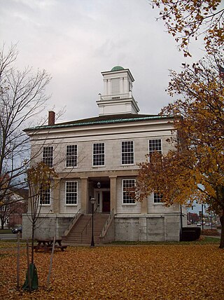
The Genesee County Courthouse is located at the intersection of Main and Ellicott streets in Batavia, New York, United States. It is a three-story Greek Revival limestone structure built in the 1840s.

<span class="mw-page-title-main">Genesee County Courthouse Historic District</span> Historic district in New York, United States

The Genesee County Courthouse Historic District is located at the junction of Main, West Main and Ellicott streets in downtown Batavia, New York, United States. It is a small area with the county courthouse, a war memorial and other government buildings dating from the 1840s to the 1920s. Some were originally built for private purposes.

<span class="mw-page-title-main">Le Roy House and Union Free School</span> Historic buildings in New York, United States

The Le Roy House and Union Free School are located on East Main Street in Le Roy, New York, United States. The house is a stucco-faced stone building in the Greek Revival architectural style. It was originally a land office, expanded in two stages during the 19th century by its builder, Jacob Le Roy, an early settler for whom the village is named. In the rear of the property is the village's first schoolhouse, a stone building from the end of the 19th century.

<span class="mw-page-title-main">Stafford Village Four Corners Historic District</span> Historic district in New York, United States

The Stafford Village Four Corners Historic District is located at the junction of New York state routes 5 and 237 in Stafford, New York, United States. It is a collection of six buildings of various types from the 19th century, one of which is the oldest house in Genesee County.

The Treaty of Big Tree was a formal treaty signed in 1797 between the Seneca Nation and the United States, in which the Seneca relinquished their rights to nearly all of their traditional homeland in New York State—nearly 3.5 million acres. In the 1788 Phelps and Gorham Purchase, the Haudenosaunee (Iroquois) had previously sold rights to their land between Seneca Lake and the Genesee River. The Treaty of Big Tree signed away their rights to all their territory west of the Genesee River except 12 small tracts of land for $100,000 and other considerations. The money was not paid directly to the tribe, but was to be invested in shares of the Bank of the United States, and to be paid out to the Senecas in annual earnings of up to six percent, or $6,000 a year, on the bank stock.

<span class="mw-page-title-main">F.W. Caulkins</span>

Franklin Wellington Caulkins was a prominent architect in Buffalo, New York.

<span class="mw-page-title-main">Batavia, New York</span> City in New York, United States

Batavia is a city in and the county seat of Genesee County, New York, United States. It is near the center of the county, surrounded by the Town of Batavia, which is a separate municipality. Batavia's population as of the 2020 census was 15,600. The name Batavia is Latin for the Betuwe region of the Netherlands, and honors early Dutch land developers. In 2006, a national magazine, Site Selection, ranked Batavia third among the nation's micropolitans based on economic development. The New York State Thruway passes north of the city. Genesee County Airport (GVQ) is also north of the city.

References

  1. "National Register Information System". National Register of Historic Places . National Park Service. January 23, 2007.
  2. 1 2 "Holland Land Office". National Historic Landmark summary listing. National Park Service. September 12, 2007. Archived from the original on June 5, 2011. Retrieved September 13, 2007.
  3. 1 2 3 4 5 6 7 8 9 10 Richard Greenwood (January 7, 1975). "National Register of Historic Places Inventory-Nomination: Holland Land Office" (pdf). National Park Service.{{cite journal}}: Cite journal requires |journal= (help) and Accompanying 1 photo, exterior, from 1964.  (280 KB)
  4. 1 2 3 4 Shilling, Donovan A. (1999). "NSG Visits the Holland Land Office Museum". Crooked Lake Review. Retrieved December 10, 2010.
  5. Goldman, Mark (1983). High Hopes: The Rise and Decline of Buffalo, New York. Albany, NY: State University of New York Press. p. 45. ISBN   0-87395-735-0.
  6. Thompson, John Henry (1966). Geography of New York State. Syracuse, N.Y.: Syracuse University Press. p. 152.
  7. 1 2 3 4 "Holland Land Office Museum History". Holland Land Office Museum. Archived from the original on June 6, 2010. Retrieved December 10, 2010.