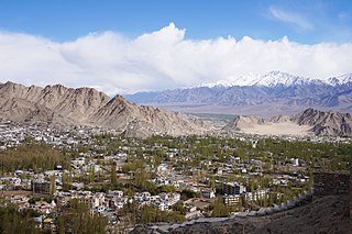
Leh is the joint capital and largest city of Ladakh, a union territory of India. Leh, located in the Leh district, was also the historical capital of the Kingdom of Ladakh, the seat of which was in the Leh Palace, the former residence of the royal family of Ladakh, built in the same style and about the same time as the Potala Palace in Tibet. Leh is at an altitude of 3,524 m (11,562 ft), and is connected via National Highway 1 to Srinagar in the southwest and to Manali in the south via the Leh-Manali Highway.
Rohtang Pass is a high mountain pass on the eastern end of the Pir Panjal Range of the Himalayas around 51 km (32 mi) from Manali in the Indian state of Himachal Pradesh. It connects the Kullu Valley with the Lahaul and Spiti Valleys of Himachal Pradesh, India.
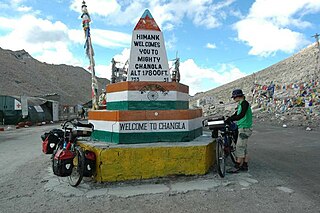
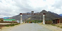
Chang La is a high mountain pass in Ladakh at an elevation of 5,391.3024 m or 17,688.000 ft in the Ladakh Range between Leh and the Shyok River valley. The Chang La, on Leh to Pangong Lake road, lies on the Leh-Karu-Sakti-Zingral-Chang La-Durbuk-Tangtse-Pangong Lake motorable road. Karu, which lies on Leh-Manali NH-3, connects Chang La and Pangong Lake to Leh and the rest of India. In September 2021, BRO opened another alternate motorable asphalt road between Zingral and Tangtse via Ke La pass and Taruk.

Hemis National Park is a high-elevation national park in Ladakh, India. Globally famous for its snow leopards, it is believed to have the highest density of them in any protected area in the world. It is the only national park in India that is north of the Himalayas, the largest notified protected area in India and is the second largest contiguous protected area, after the Nanda Devi Biosphere Reserve and surrounding protected areas. The park is home to a number of species of endangered mammals, including the snow leopard. Hemis National Park is India's protected area inside the Palearctic realm, outside the Changthang Wildlife Sanctuary northeast of Hemis, and the proposed Tso Lhamo Cold Desert Conservation Area in North Sikkim.
Leh district is a district in the union territory of Ladakh, India. With an area of 45,110 km2, it is the second largest district in the country smaller only to Kutch. It is bounded on the north by Gilgit-Baltistan's Kharmang and Ghanche districts and Xinjiang's Kashgar Prefecture and Hotan Prefecture linked via the historic Karakoram Pass. It has Aksai Chin and Tibet are to the east, Kargil district to the west, and Lahul and Spiti to the south. The district headquarters is in Leh. It lies between 32 to 36 degree north latitude and 75 to 80 degree east longitude.

Tourism is one of an economic contributor to the union territory of Ladakh in Northern India. The union territory is sandwiched between the Karakoram mountain range to the north and the Himalayas to the south and is situated at the height of 11,400 ft. Ladakh is composed of the Leh and Kargil districts. The region contains prominent Buddhist sites and has an ecotourism industry.
Lachulung La, or Lāchālūng La or Lungalacha La, is a paved motorable mountain pass in Ladakh in India just north of border with Himachal Pradesh. It is located on the NH3 Leh–Manali Highway, 54 km (34 mi) north of Sarchu and 24 km (15 mi) west of Pang. Rail-cum-road tunnel is being constructed under this pass to cater for the traffic for existing NH3 & under-construction Bhanupli–Leh line, Bara-lacha la and Taglang La are other tunnels being constructed on this route.

Hemis, also spelled Hamis, is a village in the Leh district of Ladakh, India. It is located in the Kharu tehsil, 40 km southeast of Leh town on the Leh-Manali Highway and under-construction Bhanupli–Leh line.

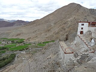
Hemis Monastery is a Himalayan Buddhist monastery (gompa) of the Drukpa Lineage, in Hemis, Ladakh, India. Situated 45 km from Leh, it was re-established in 1672 by the Ladakhi king Sengge Namgyal. The annual Hemis festival honouring Padmasambhava is held there in early June.

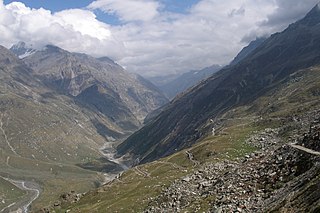
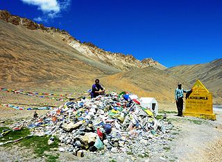
The Leh–Manali Highway is a 428 km (266 mi) long highway in northernmost India connecting Leh, the capital of the Union Territory of Ladakh, to Manali in the state of Himachal Pradesh. It connects the Manali Solang valley to the Lahaul and Spiti valleys in Himachal Pradesh and the Zanskar valley in Ladakh. It is open for about six months in a year from the first week of May to October, when snowfall again blocks the high passes on the highway. Earlier the highway was closed beyond Rohtang Pass during winter but after commissioning of the Atal tunnel, the road now remains open beyond the tunnel. Lahaul valley now remains connected to Manali for most part of the year through Atal tunnel. With the completion of proposed Shingo La Tunnel on new route through Zanskar valley, targeted to be completed by 2025, the whole Leh-Manali route will become an all-weather road.
The development of tribal areas in Himachal Pradesh is one of the major steps taken by the state government for its economic development. The border districts of Kinnaur, Lahaul, Spiti and the Pangi and Bharmour tehsils of Chamba districts are the major tribal areas of the state. They are located near the borders of Tibet and Indian States of Jammu and Kashmir. Other backward areas include Shillai in Sirmaur district, and deep cut-off valleys in the Kullu and upper stretches of Kangra districts. Due to poor accessibility, life in these areas had grown in isolation.

Sarchu is a major halt point with tented accommodation in the Himalayas on the Leh-Manali Highway, on the boundary between Himachal Pradesh and Ladakh in India. It is situated between Baralacha La to the south and Lachulung La to the north, at an altitude of 4,201 m (13,783 ft).

More plains, originally called Kiang Chu Thang in the local language, is a plateau on the Leh–Manali Highway. Kiang Chu Thang means a plain where the kiang does not find water. It occupies 40 km of the highway between Leh and Pang. The plateau has an average elevation of 4,800 metres. The road is flanked by beautiful mountains on both sides. At some places, it runs along the Sumkhel Lungpa River, featuring stunning sand and rock natural formations.

National Highway 1D, also known as Srinagar-Leh Highway, was a National Highway entirely within the union territory of Jammu and Kashmir and Ladakh in North India that connected Srinagar to Leh in Ladakh. It was one of the only two roads that connected Ladakh with the rest of India, the other being Leh-Manali Highway. The Srinagar-Leh Highway was declared as National Highway in 2006.
Nyoma is a principal village of southern Ladakh in India, the headquarters of an eponymous subdivision, tehsil and community development block in the Leh district. It is located on the bank of the Indus river, after its 90-degree bend near Dungti and before the valley narrows to a gorge near Mahe. A Buddhist monastery ("gompa") is located on the hill at the back of the village.
Bhanupli–Leh line is an under-construction high-elevation all-weather 1,676 mm broad gauge railway track connecting Bhanupli in Punjab to Leh in Ladakh union territory of India. The 465-km-long line, at a height of 5360m above mean sea level, with 10 hours travel time from New Delhi to Leh, will become the highest railway in the world surpassing the Qinghai–Tibet railway in China at 5068m.

National Highway 1 in India runs between the union territories of Jammu & Kashmir and Ladakh. It comprises parts of old NH1A and NH1D. The number 1 indicates, under the new numbering system, that it is the northernmost East-West highway in India.
Demchok , previously called New Demchok, and called Parigas by the Chinese, is a village and military encampment in the Indian-administered Demchok sector that is disputed between India and China. It is administered as part of the Nyoma tehsil in the Leh district of Ladakh by India, and claimed by China as part of the Tibet Autonomous Region.
The Darbuk–Shyok–DBO Road, also called the Sub-Sector North Road, is a strategic all-weather road in eastern Ladakh in India, close to the Line of Actual Control with China. It connects Ladakh's capital city Leh, via the villages of Darbuk and Shyok at southern Shyok River Valley, with the Daulat Beg Oldi (DBO) post near the northern border. The 220-km long section between Shyok and DBO was constructed between 2000 and 2019 by India's Border Roads Organisation (BRO). The DS-DBO Road has reduced the travel time between Leh to DBO from 2 days to 6 hours.
Spangmik is a settlement on the southern bank of the Pangong Lake in Ladakh, India. It is located between Lukung and Man. Tourists visiting the Pangong Lake in India are allowed to travel up to Spangmik, beyond which it is considered sensitive border area with China.