List of extreme points of Russia

Last updated

Extreme points of Russia Extreme points of Russia.png
Extreme points of Russia

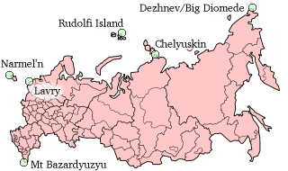
This is a list of the extreme points and extreme elevations in Russia.

Contents

The northernmost and easternmost points of Russia coincide with those of Eurasia (both for the mainland and including the islands).

The extreme points of the Soviet Union were identical, except that the southernmost point of the Soviet Union was Kushka in Turkmenistan, and the extreme elevation was the Communism Peak in Tajikistan, at 7,495 metres (24,590 ft). The other extreme points of Russia are the same as those of the Soviet Union.

From 1799 until 1867 the easternmost point of the Russian Empire was located in North America, on the border between Russian Alaska and British North America, which superimposed on the then International Date Line. The westernmost point of the Empire was located at Ruda Komorska in Congress Poland from 1815 until its occupation by German and Austro-Hungarian troops in 1915. Kushka in present-day Turkmenistan had been the southernmost point of the Empire since 1885. Again, until the Alaska Purchase, the peak of Bolshaya was the extreme point of elevation in the Empire, at 6,194 m above sea level.

Extreme coordinates

Including islands and exclaves

Cape Fligely Kap Fligely 4 2012-08-10.jpg
Cape Fligely

Contiguous mainland only

Towns and cities

The town of Pevek Pevek, 5-yi mikroraion.jpg
The town of Pevek

Permanent settlements

1according to the path of the International Date Line, although being located in the Western Hemisphere.

Elevation extremes

Mount Elbrus El'brus s perevala Gumbashi.JPG
Mount Elbrus

Extreme distances

See also

Related Research Articles

<span class="mw-page-title-main">Chukotka Autonomous Okrug</span> First-level administrative division of Russia

Chukotka, officially the Chukotka Autonomous Okrug, is the easternmost federal subject of Russia. It is an autonomous okrug situated in the Russian Far East, and shares a border with the Sakha Republic to the west, Magadan Oblast to the south-west, and Kamchatka Krai to the south, as well as a maritime border on the Bering Strait with the U.S. state of Alaska to the east. Anadyr is the largest town and the capital, and the easternmost settlement to have town status in Russia. It is the closest point from Russia to the United States, measuring at 88.51 kilometres or 55 miles.

<span class="mw-page-title-main">Extreme points of Ireland</span>

This is a list of the extreme points of Ireland – the points that are farthest north, south, east or west in Ireland. It includes the Republic of Ireland and Northern Ireland.

This is a list of the extreme points of Europe: the geographical points that are higher or farther north, south, east or west than any other location in Europe. Some of these positions are open to debate, as the definition of Europe is diverse.

This is a list of the extreme points of Asia, the points that are farther north, south, east or west than any other location on the continent.

<span class="mw-page-title-main">Extreme points of Eurasia</span>

This is a list of the extreme points of Eurasia, the points that are farther north, south, east or west than any other location on the continent. Some of these locations are open to debate, owing to the diverse definitions of Europe and Asia.

The extreme points of Norway include the coordinates that are farther north, south, east or west than any other location in Norway; and the highest and the lowest altitudes in the country. The northernmost point is Rossøya on Svalbard, the southernmost is Pysen in Lindesnes Municipality, the easternmost is Kræmerpynten on Svalbard, and the westernmost is Hoybergodden on Jan Mayen. The highest peak is Galdhøpiggen, standing at 2,469 m (8,100 ft) above mean sea level, while the lowest elevation is sea level at the coast.

<span class="mw-page-title-main">Eastern European Time</span> Time zone in Eastern Europe (GMT +2)

Eastern European Time (EET) is one of the names of UTC+02:00 time zone, 2 hours ahead of Coordinated Universal Time. The zone uses daylight saving time, so that it uses UTC+03:00 during the summer.

<span class="mw-page-title-main">Chukchi Peninsula</span> Peninsula on the eastern coast of Siberia

The Chukchi Peninsula, at about 66° N 172° W, is the easternmost peninsula of Asia. Its eastern end is at Cape Dezhnev near the village of Uelen. The Chukotka Mountains are located in the central/western part of the peninsula, which is bounded by the Chukchi Sea to the north, the Bering Sea to the south, and the Bering Strait to the east, where at its easternmost point it is only about 60 km (37 mi) from Seward Peninsula in Alaska; this is the smallest distance between the land masses of Eurasia and North America. The peninsula is part of Chukotka Autonomous Okrug of Russia.

<span class="mw-page-title-main">Anadyr (town)</span> Town in Chukotka Autonomous Okrug, Russia

Anadyr is a port town and the administrative center of Chukotka Autonomous Okrug, Russia, located at the mouth of the Anadyr River at the tip of a peninsula that protrudes into Anadyrsky Liman. It was previously known as Novo-Mariinsk. Anadyr is the easternmost town in Russia; more easterly settlements, such as Provideniya and Uelen, do not have town status.

This is a list of points in the Philippines that are farther north, south, east, or west than any other location in the country. Also included are extreme points in elevation, extreme distances, and other points of geographic interest.

<span class="mw-page-title-main">Afro-Eurasia</span> Landmass consisting of Africa, Asia, and Europe

Afro-Eurasia is a landmass comprising the continents of Africa, Europe, and Asia. The terms are compound words of the names of its constituent parts. Afro-Eurasia has also been called the "Old World", in contrast to the "New World" referring to the Americas.

This is a list of the extreme points of the Commonwealth of Nations — the points that are farther north, south, east or west, or higher or lower in elevation than any other location.

<span class="mw-page-title-main">Anadyrsky District</span> District in Chukotka Autonomous Okrug, Russia

Anadyrsky District is an administrative and municipal district (raion), one of the six in Chukotka Autonomous Okrug, Russia. It is located in the central and southern parts of the autonomous okrug and borders with Chaunsky District in the northwest, Iultinsky District in the north and northeast, the Gulf of Anadyr in the east, Koryak Okrug in the south, and with Bilibinsky District in the west and northwest. It also completely surrounds the territory of the town of okrug significance of Anadyr. The area of the district is 287,900 square kilometers (111,200 sq mi). Its administrative center is the town of Anadyr. Population: 8,161 (2021 Census); 6,935 (2010 Census); 8,007 (2002 Census); 40,475 (1989 Soviet census).

This is a list of the extreme points of Colombia, the points that are farther north, south, east or west than any other location.

References

  1. 1 2 3 "The Most Extreme Points of Russia". WorldAtlas. Retrieved 22 November 2024.
  2. Маршрут Раякоски - Анадырский район
  3. Маршрут Раякоски - Хасан