Massachusetts's congressional districts

Last updated

Map of Massachusetts's congressional districts since 2023
Interactive map version Massachusetts Congressional Districts, 118th Congress.svg
Map of Massachusetts's congressional districts since 2023
Interactive map version

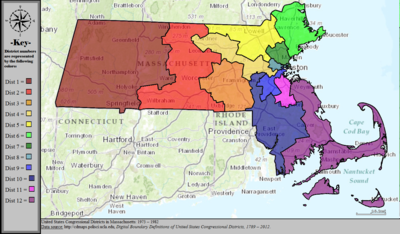
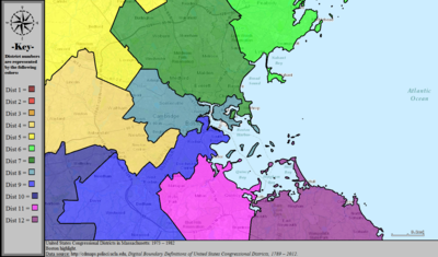
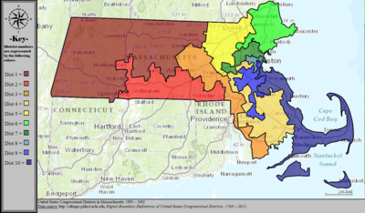
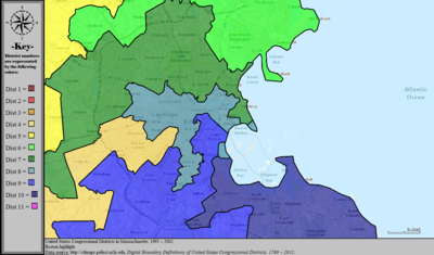
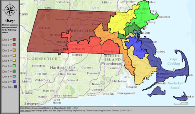
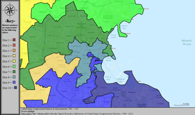
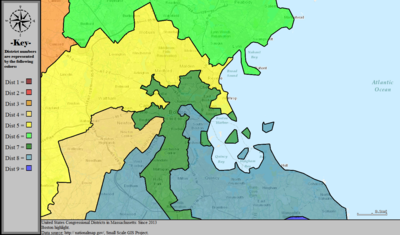
Massachusetts is currently divided into 9 congressional districts, each represented by a member of the United States House of Representatives. After the 2010 census, the number of seats in Massachusetts was decreased from 10 to 9, due to the State's low growth in population since the year 2000. This mandatory redistricting after the 2010 census eliminated Massachusetts's 10th congressional district, as well as causing a major shift in how the state's congressional districts are currently drawn.

Contents

Current districts and representatives

This is a list of United States representatives from Massachusetts in the 118th Congress, their terms, their district boundaries, and the district political ratings, according to the CPVI. The delegation has a total of nine members, all of whom are members of the Democratic party. It is the most populous state in which all members are from the same party.

Current U.S. representatives from Massachusetts
DistrictMember
(Residence) [1]
PartyIncumbent since CPVI
(2025) [2]
District map
1st Richard Neal official photo (cropped).jpg
Richard Neal
(Springfield)
DemocraticJanuary 3, 1989D+8
Massachusetts's 1st congressional district (since 2023).svg
2nd Jim McGovern, official portrait, 116th Congress.jpg
Jim McGovern
(Worcester)
DemocraticJanuary 3, 1997D+13
Massachusetts's 2nd congressional district (since 2023).svg
3rd Lori Trahan, official portrait, 116th Congress.jpg
Lori Trahan
(Westford)
DemocraticJanuary 3, 2019D+11
Massachusetts's 3rd congressional district (since 2023).svg
4th Jake Auchincloss, 117th Congress portrait.jpg
Jake Auchincloss
(Newton)
DemocraticJanuary 3, 2021D+11
Massachusetts's 4th congressional district (since 2023).svg
5th Katherine Clark, official portrait, 118th Congress (cropped 2).jpg
Katherine Clark
(Revere)
DemocraticDecember 12, 2013D+24
Massachusetts's 5th congressional district (since 2023).svg
6th Seth Moulton (cropped).jpg
Seth Moulton
(Salem)
DemocraticJanuary 3, 2015D+11
Massachusetts's 6th congressional district (since 2023).svg
7th Rep. Ayanna Pressley, 117th Congress.jpg
Ayanna Pressley
(Boston)
DemocraticJanuary 3, 2019D+34
Massachusetts's 7th congressional district in Boston (since 2023).svg
8th Stephen Lynch 2019.jpg
Stephen Lynch
(Boston)
DemocraticOctober 16, 2001D+15
Massachusetts's 8th congressional district in Boston (since 2023).svg
9th Bill Keating official photo.jpg
Bill Keating
(Bourne)
DemocraticJanuary 3, 2011D+6
Massachusetts's 9th congressional district (since 2023).svg

History of apportionment

Census
year
Resident
population [nb 1]
Number of
representatives [nb 2]
Constituents
per representative
(Massachusetts)
Constituents
per representative
(nationally)
1789No census8N/AN/A
1790 378,7871427,05630,000
1800 422,8451724,87333,000
1810 472,0402023,60235,000
1820 523,2871340,25340,000
1830 610,4081250,86747,700
1840 737,6991073,77070,680
1850 994,5141190,41093,425
1860 1,231,06610123,107127,381
1870 1,457,35111132,486131,425
1880 1,783,08512148,590151,912
1890 2,238,94713172,227173,901
1900 2,805,34614200,381194,182
1910 3,366,41616210,401212,407
1920 3,852,35616N/AN/A
1930 4,249,61415283,307280,675
1940 4,316,72114308,337301,164
1950 4,690,51414335,037344,587
1960 5,148,57812429,048410,481
1970 5,689,17012477,223469,088
1980 5,737,09311521,549519,235
1990 6,016,42510602,905572,466
2000 6,349,09710635,557646,952
2010 6,547,6299 [3] [4] 728,849710,767

Source: U.S. Census Bureau.

After the 1890 census, and starting with the 53rd United States Congress in 1893, Massachusetts's congressional districts were numbered west to east, with the first district in the west (Berkshire County) and the highest numbered district at Cape Cod. Before then, the district numeration was not as consistent; sometimes running east to west, other times going counter-clockwise around Boston.

Historical and present district boundaries

Table of United States congressional district boundary maps in the State of Massachusetts, presented chronologically. [5] All redistricting events that took place in Massachusetts between 1973 and 2013 are shown.

YearStatewide mapBoston highlight
1973–1982 United States Congressional Districts in Massachusetts, 1973 - 1982.tif United States Congressional Districts in Massachusetts (metro highlight), 1973 - 1982.tif
1983–1992 United States Congressional Districts in Massachusetts, 1983 - 1992.tif United States Congressional Districts in Massachusetts (metro highlight), 1983 - 1992.tif
1993–2002 United States Congressional Districts in Massachusetts, 1993 - 2002.tif United States Congressional Districts in Massachusetts (metro highlight), 1993 - 2002.tif
2003–2013 United States Congressional Districts in Massachusetts, 2003 - 2013.tif United States Congressional Districts in Massachusetts (metro highlight), 2003 - 2013.tif
2013-2023 United States Congressional Districts in Massachusetts, since 2013.tif United States Congressional Districts in Massachusetts (metro highlight), since 2013.tif
Since 2023 Massachusetts Congressional Districts, 118th Congress.svg

See also

Notes

  1. The resident population excludes the overseas population.
  2. Congressional apportionment for each state is based upon (1) the resident population and (2) the overseas U.S. military and federal civilian employees (and their dependents living with them) allocated to their home state, as reported by the employing federal agencies.

References

  1. "Office of the Clerk, U.S. House of Representatives". clerk.house.gov. Retrieved January 6, 2022.
  2. "2025 Cook PVI: District Map and List". Cook Political Report. Retrieved April 4, 2024.
  3. "Deval Patrick Signs New Massachusetts Map", Roll Call , Washington, DC, November 21, 2011
  4. "Massachusetts Redistricting Analysis". Daily Kos . November 14, 2011. Retrieved November 27, 2013.
  5. "Digital Boundary Definitions of United States Congressional Districts, 1789–2012" . Retrieved October 18, 2014.

Further reading

19th century

20th century

21st century