This list presents the full set of buildings, structures, objects, sites, or districts designated on the National Register of Historic Places in Curry County, Oregon, and offers brief descriptive information about each of them. The National Register recognizes places of national, state, or local historic significance across the United States. [1] Out of over 90,000 National Register sites nationwide, [2] Oregon is home to over 2,000, [3] and 46 of those are found in Curry County.
This National Park Service list is complete through NPS recent listings posted March 4, 2022. [4]
[5] | Name on the Register | Image | Date listed [6] | Location | City or town | Description |
---|---|---|---|---|---|---|
1 | 35-CU-215–High Point Shell Midden | March 6, 2001 (#01000135) | Address restricted [7] | Carpenterville vicinity | 
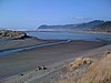
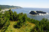
This shell midden is located on a strategic high point overlooking the Pacific coast, and is visible in the eroding cliff face. Radiocarbon dating indicates that the site was occupied c. 1070 CE and again c. 1385 CE, but additional dating may extend this chronology. [8] | |
2 | Arch Rock | September 10, 1997 (#97001058) | Address restricted [7] | Carpenterville | ||
3 | Archeological Site 35CU1 | September 10, 1997 (#97001043) | Address restricted [7] | Sixes | ||
4 | Archeological Site 35CU13 | September 10, 1997 (#97001045) | Address restricted [7] | Port Orford | ||
5 | Archeological Site 35CU14 | September 10, 1997 (#97001046) | Address restricted [7] | Port Orford | ||
6 | Archeological Site 35CU142 | September 10, 1997 (#97001050) | Address restricted [7] | Port Orford | ||
7 | Archeological Site 35CU153 | September 10, 1997 (#97001049) | Address restricted [7] | Port Orford | ||
8 | Archeological Site 35CU16 | September 10, 1997 (#97001048) | Address restricted [7] | Port Orford | ||
9 | Archeological Site 35CU31 | September 10, 1997 (#97001055) | Address restricted [7] | Pistol River | ||
10 | Archeological Site 35CU69 | September 10, 1997 (#97001066) | Address restricted [7] | Carpenterville | ||
11 | Archeological Site 35CU79 | September 10, 1997 (#97001070) | Address restricted [7] | Brookings | ||
12 | Archeological Site 35CU80 | September 10, 1997 (#97001069) | Address restricted [7] | Brookings | ||
13 | Archeological Site 35CU83 | September 10, 1997 (#97001042) | Address restricted [7] | Sixes | ||
14 | Blacklock Point Lithic Site | August 5, 1994 (#94000805) | Address restricted [7] | Port Orford | ||
15 | Blacklock Point Shell Midden | August 5, 1994 (#94000804) | Address restricted [7] | Port Orford | ||
16 | Cape Blanco Lighthouse | April 21, 1993 (#73002339) | Westernmost part of Cape Blanco, W of Sixes 42°50′14″N124°33′44″W / 42.837222°N 124.562222°W | Sixes | ||
17 | Cape Blanco Lithic Site | June 4, 1992 (#92000667) | Address restricted [7] | Port Orford | ||
18 | Central Building | April 1, 1980 (#80003309) | 703 Chetco Ave. 42°03′06″N124°16′55″W / 42.051667°N 124.281944°W | Brookings | Built in 1915 by the C&O Lumber Company, the Central Building served as administration building for the Brookings Land & Townsite Co. in the mill town of Brookings. | |
19 | Eagle Rock | September 10, 1997 (#97001054) | Address restricted [7] | Pistol River | ||
20 | Gold Beach Ranger Station | April 8, 1986 (#86000818) | 29279 Ellensburg Avenue 42°24′07″N124°25′08″W / 42.401944°N 124.418889°W | Gold Beach | The Cascadian Rustic buildings of the Gold Beach Ranger Station were built in 1936 by a Civilian Conservation Corps crew from Gasquet, California. | |
21 | Zane Grey Cabin [lower-alpha 1] | June 28, 2016 (#16000413) | North bank of the Rogue River 42°42′07″N123°48′17″W / 42.701871°N 123.804688°W | Galice vicinity | 
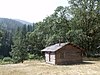
Zane Grey (1872–1939), the master author of the American West, built this cabin on the lower Rogue River in 1926 and used it as a frequent retreat until 1935. He both wrote here and used the surrounding landscapes as inspiration for works such as Tales of Freshwater Fishing, Rogue River Feud, and the article "Shooting the Rogue". [11] | |
22 | Harris Park Mound | September 10, 1997 (#97001068) | Address restricted [7] | Brookings | ||
23 | Patrick Hughes House | November 28, 1980 (#80003310) | Cape Blanco State Park 42°50′33″N124°32′13″W / 42.8425°N 124.536944°W | Sixes | The Hughes House, which combines elements of the Queen Anne and Stick-Eastlake architectural styles, was designed by P.J. Lindberg and built in 1898. | |
24 | Mary D. Hume | August 1, 1979 (#79002052) | Port of Gold Beach 42°25′18″N124°25′06″W / 42.421667°N 124.418333°W | Gold Beach | Steamer built in 1880 in Gold Beach, wrecked at Gold Beach | |
25 | Indian Sands | September 10, 1997 (#97001061) | Address restricted [7] | Carpenterville | ||
26 | Indian Sands | June 4, 1992 (#92000668) | Address restricted [7] | Brookings | ||
27 | Khustenete-Hustenate-Xusteneten | September 10, 1997 (#97001057) | Address restricted [7] | Carpenterville | ||
28 | Peter John Lindberg House | January 7, 2015 (#14001131) | 906 N. Washington Street 42°44′46″N124°29′44″W / 42.746038°N 124.495638°W | Port Orford | ||
29 | Little Ridge-Cape Sebastian (35CU77) | September 10, 1997 (#97001051) | Address restricted [7] | Pistol River | ||
30 | Little Ridge-Cape Sebastian (35CU78) | September 10, 1997 (#97001052) | Address restricted [7] | Pistol River | ||
31 | Lone Ranch Creek Mound | September 10, 1997 (#97001067) | Address restricted [7] | Brookings | ||
32 | Miller Creek | September 10, 1997 (#97001059) | Address restricted [7] | Carpenterville | Also known as the Miller Shell Midden. | |
33 | Newburgh Lithic Site (35CU209) | September 10, 1997 (#97001041) | Address restricted [7] | Sixes | ||
34 | Pistol River Site-Chetlessentan-Chetleshin-Chet-less-chun-dunn | September 10, 1997 (#97001053) | Atop bluffs immediately north of the mouth of the Pistol River [12] : 322 42°16′52″N124°24′05″W / 42.281111°N 124.401389°W | Pistol River | ||
35 | Port Orford Coast Guard Station | May 29, 1998 (#98000606) | 92331 Coast Guard Hill Rd. 42°44′23″N124°30′33″W / 42.739722°N 124.509167°W | Port Orford | ||
36 | Port Orford Site | September 10, 1997 (#97001044) | Address restricted [7] | Port Orford | ||
37 | Rogue River Bridge No. 01172 | August 5, 2005 (#05000814) | OR Coast 9, US 101, MP 327.70 42°25′39″N124°24′44″W / 42.4275°N 124.412222°W | Gold Beach | Also known as the Isaac Lee Patterson Bridge. | |
38 | Rogue River Ranch | December 29, 1975 (#75001581) | E of Agness near confluence of Mule Creek and Rogue River 42°43′06″N123°52′53″W / 42.718333°N 123.881389°W | Agness | ||
39 | Sheep Trail Shell Midden (35CU32) | September 10, 1997 (#97001056) | Address restricted [7] | Carpenterville | ||
40 | Sixes Hotel | October 22, 1992 (#92001325) | 93316 Sixes River Rd. 42°49′04″N124°28′50″W / 42.817724°N 124.480421°W | Sixes | ||
41 | Thunder Rock | September 10, 1997 (#97001060) | Address restricted [7] | Carpenterville | ||
42 | Whale Head | September 10, 1997 (#97001062) | Address restricted [7] | Carpenterville | ||
43 | Whaleshead Lithic Site (35CU207) | September 10, 1997 (#97001064) | Address restricted [7] | Carpenterville | ||
44 | Whaleshead South Midden (35CU208) | September 10, 1997 (#97001063) | Address restricted [7] | Carpenterville | ||
45 | Whaleshead Trail Viewpoint (35CU36) | September 10, 1997 (#97001065) | Address restricted [7] | Carpenterville | ||
46 | Wheeler Ridge Japanese Bombing Site | July 6, 2006 (#06000589) | Rogue River-Siskiyou National Forest 42°04′42″N124°06′40″W / 42.078333°N 124.111111°W | Brookings | Site of first bombing in the United States by airplane |
[5] | Name on the Register | Image | Date listed | Date removed | Location | City or town | Description |
---|---|---|---|---|---|---|---|
1 | Archeological Site 35CU156 | September 10, 1997 (#97001047) | April 29, 2010 | Address restricted [7] | Port Orford |