Taigum, Queensland

Last updated

Taigum
Brisbane,  Queensland
St Paraskevi Greek Orthodox Church, 241 Church Road, Taigum, 2007.jpg
St Paraskevi Greek Orthodox Church, 2007
Australia Queensland location map.svg
Red pog.svg
Taigum
Coordinates 27°20′30″S153°02′46″E / 27.3416°S 153.0461°E / -27.3416; 153.0461 (Taigum (centre of suburb))
Population7,801 (2021 census) [1]
 • Density2,600/km2 (6,730/sq mi)
Established1975
Postcode(s) 4018
Area3.0 km2 (1.2 sq mi)
Time zone AEST (UTC+10:00)
Location22.9 km (14 mi) N of Brisbane CBD
LGA(s) City of Brisbane
(Deagon Ward) [2]
State electorate(s) Sandgate
Federal division(s) Lilley
Suburbs around Taigum:
Fitzgibbon Deagon Deagon
Fitzgibbon Taigum Boondall
Fitzgibbon Zillmere Boondall

Taigum is a northern suburb in the City of Brisbane, Queensland, Australia. [3] In the 2021 census, Taigum had a population of 7,801 people. [1]

Contents

Geography

The suburb is bounded to the west and north by Cabbage Tree Creek, to the east by Muller Road, and to the south by Beams Road. [4]

History

The Tighgum area (now known as Taigum) was first developed around 1853, as part of a subdivision of the Nundah Division. In 1891, it was suggested, unsuccessfully, by the board that the name be changed to "Tyghum Divisional Board" and Tighgum Creek was also the original and alternate name in brackets for Cabbage tree Creek. [5]

The suburb name was officially recognised on 11 August 1975. [6] The name is derived from an Aboriginal word for lawyer cane. The word Taghum was used as alternative to cabbage in Cabbage Tree Creek. [6]

Zillmere North State School opened on 29 January 1957 on a 12-hectare (30-acre) site. In 1993, it was renamed Taigum State School. [7] [8]

Taigum Square shopping centre opened in 1982 and was expanded in 2001. [9]

St. Paraskevi Greek Orthodox Church at 241 Church Road was founded on 23 April 1986. [10] [11] It was named after Paraskevi of Rome. The cornerstone was laid on 29 November 1987 by Archbishop Stylianos and the church officially opened on 10 December 1995. [12] It serves as home to the Taigum Child Care Centre. [10] [13]

The Centrepoint Church in Taigum opened at 205 Beams Road on 30 May 2021 as a second church location of the Centrepoint Church in Chermside. [14] The building formerly belonged to the iSee Church. [15] [16]

Demographics

In the 2011 census, Taigum had a population of 5,619 proplr, 53.7% female and 46.3% male. The median age of the Taigum population was 39 years, 2 years above the Australian median. 65.9% of people living in Taigum were born in Australia, compared to the national average of 69.8%; the next most common countries of birth were New Zealand 5.2%, Philippines 3.8%, England 3.7%, India 3.2%, Fiji 1.2%. 78.1% of people spoke only English at home; the next most common languages were 2.1% Tagalog, 1.5% Punjabi, 1.2% Filipino, 1.1% Hindi, 1.1% Italian. Over 38% of households in this area were couples with children, 40% were of couples without children and 18% were single parent households. Over 61% of residential developments were houses and another 25% were townhouses. [17]

In the 2016 census, Taigum had a population of 6,495 people. [18]

In the 2021 census, Taigum had a population of 7,801 people. [1]

Education

Taigum State School is a government primary (Early Childhood-6) school for boys and girls at 266 Handford Road ( 27°20′52″S153°02′25″E / 27.3478°S 153.0402°E / -27.3478; 153.0402 (Taigum State School) ). [19] [20] In 2018, the school had an enrolment of 406 students with 35 teachers (30 full-time equivalent) and 28 non-teaching staff (15 full-time equivalent). [21] It includes a special education program. [19]

There are no secondary schools in Taigum. The nearest government secondary schools are Sandgate District State High School in neighbouring Deagon to the north and Aspley State High School in Aspley to the south-west. [4]

Amenities

Taigum Tavern, 2021 Taigum Tavern, Brisbane, 2012.jpg
Taigum Tavern, 2021

Taigum Square shopping centre is at 217 Beams Road ( 27°21′04″S153°02′54″E / 27.3510°S 153.0484°E / -27.3510; 153.0484 (Taigum Square shopping centre) ). [9] [22]

Centrepoint Church, 2007 Taigum Community Church, now Isee Church, 203 Beams Road, Taigum 02.jpg
Centrepoint Church, 2007

Centrepoint Church is at 203 Beams Road ( 27°23′17″S153°02′36″E / 27.3880°S 153.0433°E / -27.3880; 153.0433 (Centrepoint Church) ). It is part of the Australian Christian Churches network. [14] [23]

St Paraskevi Greek Orthodox Church is at 241 Church Road ( 27°20′54″S153°02′50″E / 27.3484°S 153.0473°E / -27.3484; 153.0473 (St. Paraskevi Greek Orthodox Church) ). It is a parish of the Greek Orthodox Archdiocese of Australia, part of the Ecumenical Patriarchate of Constantinople. [24]

Related Research Articles

<span class="mw-page-title-main">Mansfield, Queensland</span> Suburb of Brisbane, Queensland, Australia

Mansfield is a suburb in the City of Brisbane, Queensland, Australia. In the 2021 census, Mansfield had a population of 8,851 people.

<span class="mw-page-title-main">Aspley, Queensland</span> Suburb of Brisbane, Queensland, Australia

Aspley is a suburb in the City of Brisbane, Queensland, Australia. In the 2021 census, Aspley had a population of 12,871 people.

<span class="mw-page-title-main">Chermside, Queensland</span> Suburb of Queensland, Australia

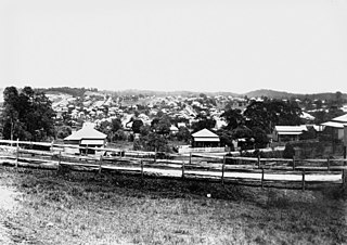
Chermside is a suburb in the City of Brisbane, Queensland, Australia. The suburb is situated 9.8 kilometres (6.1 mi) by road north of the Brisbane CBD. It is home to a large Westfield shopping centre. In the 2021 census, Chermside had a population of 11,426 people.

<span class="mw-page-title-main">Alderley, Queensland</span> Suburb of Brisbane, Queensland, Australia

Alderley is a northern suburb in the City of Brisbane, Queensland, Australia. In the 2021 census, Alderley had a population of 6,748 people.

<span class="mw-page-title-main">Carseldine, Queensland</span> Suburb of Brisbane, Queensland, Australia

Carseldine is a suburb in the City of Brisbane, Queensland, Australia. In the 2021 census, Carseldine had a population of 10,093 people.

<span class="mw-page-title-main">Chermside West, Queensland</span> Suburb of Brisbane, Queensland, Australia

Chermside West is a suburb in the City of Brisbane, Queensland, Australia. In the 2021 census, Chermside West had a population of 6,965 people. Parts of Chermside West were formerly known as Craigslea.

<span class="mw-page-title-main">Woolloongabba</span> Suburb of Brisbane, Queensland, Australia

Woolloongabba is an inner southern suburb in the City of Brisbane, Queensland, Australia. In the 2021 census, Woolloongabba had a population of 8,687 people.

<span class="mw-page-title-main">Upper Mount Gravatt, Queensland</span> Suburb of Brisbane, Queensland, Australia

Upper Mount Gravatt is a southern suburb in the City of Brisbane, Queensland, Australia. In the 2021 census, Upper Mount Gravatt had a population of 10,800 people.

<span class="mw-page-title-main">Boondall, Queensland</span> Suburb of Brisbane, Australia

Boondall is a northern suburb in the City of Brisbane, Queensland, Australia. In the 2021 census, Boondall had a population of 9,603 people.

<span class="mw-page-title-main">Shorncliffe, Queensland</span> Suburb of Brisbane, Queensland, Australia

Shorncliffe is a coastal north-eastern suburb in the City of Brisbane, Queensland, Australia. It is on the shore of Bramble Bay, part of Moreton Bay. The suburb attracts visitors to its historic Shorncliffe pier, and Lovers Walk, a walking path along the coastline between Shorncliffe and neighbouring Sandgate. In the 2021 census, Shorncliffe had a population of 1,907 people.

<span class="mw-page-title-main">Fitzgibbon, Queensland</span> Suburb of Brisbane, Queensland, Australia

Fitzgibbon is a northern suburb of the City of Brisbane, Queensland, Australia. In the 2021 census, Fitzgibbon had a population of 6,296 people.

Newmarket is a north-west suburb in the City of Brisbane, Queensland, Australia. In the 2021 census, Newmarket had a population of 5,083 people.

<span class="mw-page-title-main">Zillmere, Queensland</span> Suburb of Brisbane, Queensland, Australia

Zillmere is a suburb in the City of Brisbane, Queensland, Australia. In the 2021 census, Zillmere had a population of 9,323 people.

<span class="mw-page-title-main">Grange, Queensland</span> Suburb of Brisbane, Queensland, Australia

Grange is a northern suburb in the City of Brisbane, Queensland, Australia. In the 2021 census, Grange had a population of 4,615 people.

<span class="mw-page-title-main">Wynnum West, Queensland</span> Suburb of Brisbane, Queensland, Australia

Wynnum West and Lindum are outer eastern suburb in the City of Brisbane, Queensland, Australia. In the 2021 census, Wynnum West had a population of 12,790 people.

<span class="mw-page-title-main">Manly West, Queensland</span> Suburb of Brisbane, Queensland, Australia

Manly West is a suburb in the City of Brisbane, Queensland, Australia. In the 2021 census, Manly West had a population of 12,436 people.

<span class="mw-page-title-main">Willawong, Queensland</span> Suburb of Brisbane, Queensland, Australia

Willawong is an outer southern suburb in the City of Brisbane, Queensland, Australia. In the 2021 census, Willawong had a population of 145 people.

<span class="mw-page-title-main">Cannon Hill, Queensland</span> Suburb of Brisbane, Queensland, Australia

Cannon Hill is a suburb in the City of Brisbane, Queensland, Australia. In the 2021 census, Cannon Hill had a population of 6,701 people.

<span class="mw-page-title-main">Deagon, Queensland</span> Suburb of Brisbane, Queensland, Australia

Deagon is an outer northern suburb in the City of Brisbane, Queensland, Australia. In the 2021 census, Deagon had a population of 3,773 people.

<span class="mw-page-title-main">Rochedale, Queensland</span> Suburb of Brisbane, Queensland, Australia

Rochedale ( "roach-dale") is an outer southern suburb in the City of Brisbane, Queensland, Australia. In the 2021 census, Rochedale had a population of 7,633 people.

References

  1. 1 2 3 Australian Bureau of Statistics (28 June 2022). "Taigum (SAL)". 2021 Census QuickStats. Retrieved 28 February 2023. OOjs UI icon edit-ltr-progressive.svg
  2. "Deagon Ward". Brisbane City Council. Archived from the original on 9 March 2017. Retrieved 12 March 2017.
  3. "Taigum – suburb in City of Brisbane (entry 41705)". Queensland Place Names. Queensland Government . Retrieved 12 February 2022.
  4. 1 2 "Queensland Globe". State of Queensland . Retrieved 3 March 2022.
  5. Brisbane : local, oral and placename history (PDF), Brisbane History Group, 1990, p. 86, archived (PDF) from the original on 3 March 2016, retrieved 4 December 2014
  6. 1 2 Roberts, Beryl (2013). Naming Brisbane: Origins of Brisbane's Suburb & Locality Names. p. 97. ISBN   9780987231529. Archived from the original on 23 December 2021. Retrieved 3 January 2022.
  7. Queensland Family History Society (2010), Queensland schools past and present (Version 1.01 ed.), Queensland Family History Society, ISBN   978-1-921171-26-0
  8. "Our school". Taigum State School. 10 March 2020. Archived from the original on 13 March 2021. Retrieved 3 March 2022.
  9. 1 2 "Taigum Square". Vicinity Centres. Archived from the original on 25 December 2020. Retrieved 25 December 2020.
  10. 1 2 "About the Parish of St Paraskevi". Taigum Child Care Centre. Archived from the original on 7 March 2021. Retrieved 20 February 2022.
  11. Google (21 February 2022). "246 Church Rd" (Map). Google Maps . Google. Retrieved 21 February 2022.
  12. "St Paraskevi Greek Orthodox Church". Churches Australia. Archived from the original on 29 October 2021. Retrieved 21 February 2022.
  13. "Taigum Child Care Centre". Taigum Child Care Centre. Archived from the original on 21 February 2022. Retrieved 3 March 2022.
  14. 1 2 "About". Centrepoint Church. Archived from the original on 6 September 2021. Retrieved 6 September 2021.
  15. Google (6 September 2021). "205 Beams Road" (Map). Google Maps . Google. Retrieved 6 September 2021.
  16. "Christmas BNE". isee-church. Archived from the original on 6 September 2021. Retrieved 6 September 2021.
  17. Australian Bureau of Statistics (31 October 2012). "Taigum". 2011 Census QuickStats. Retrieved 4 December 2014. OOjs UI icon edit-ltr-progressive.svg
  18. Australian Bureau of Statistics (27 June 2017). "Taigum (SSC)". 2016 Census QuickStats. Retrieved 20 October 2018. OOjs UI icon edit-ltr-progressive.svg
  19. 1 2 "State and non-state school details". Queensland Government. 9 July 2018. Archived from the original on 21 November 2018. Retrieved 21 November 2018.
  20. "Taigum State School". Taigum State School. 10 March 2020. Archived from the original on 13 March 2021. Retrieved 3 March 2022.
  21. "ACARA School Profile 2018". Australian Curriculum, Assessment and Reporting Authority. Archived from the original on 27 August 2020. Retrieved 28 January 2020.
  22. "Taigum Square". taigumsquare.com.au. Archived from the original on 25 December 2020. Retrieved 25 December 2020.
  23. "Centrepoint Church". Churches Australia. Archived from the original on 6 September 2021. Retrieved 6 September 2021.
  24. "St Paraskevi, Taigum, QLD". Greek Orthodox Archdiocese of Australia . Archived from the original on 27 October 2021. Retrieved 20 February 2022.