
Vero Beach South is a census-designated place (CDP) in Indian River County, Florida, United States. The population was 23,092 at the 2010 census. It is part of the Sebastian–Vero Beach Metropolitan Statistical Area.
Rome is a census-designated place (CDP) in Medina Township, Peoria County, Illinois, United States. The population of the CDP was 1,738 at the 2010 census. Rome is part of the Peoria, Illinois Metropolitan Statistical Area.

Rossville is an unincorporated community and census-designated place in Baltimore County, Maryland, United States. The population was 15,147 at the 2010 census.

North Plymouth is a census-designated place (CDP) in the town of Plymouth in Plymouth County, Massachusetts, United States. The population was 3,600 at the 2010 census. it is best known as the location of Cordage Park, a small village where the Plymouth Cordage Company was once headquartered. The village is now home to Cordage Commerce Center, a large retail development that consists of offices and stores.
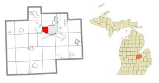
Saginaw Township South was a census-designated place (CDP) in Saginaw County in the U.S. state of Michigan. The CDP was defined for statistical purposes and had no legal status as an incorporated municipality. The population was 13,801 at the 2000 census. The community is located within Saginaw Charter Township and consists of the township south of State St., while Saginaw Township North is most of the area north of State St. This division is purely for statistical purposes and does not reflect any present or historical self-identification of the residents in these areas.

Golden Triangle is an unincorporated community and census-designated place (CDP) located within Cherry Hill Township, in Camden County, New Jersey, United States. As of the 2010 United States Census, the CDP's population was 4,145.

Laurel Lake is an unincorporated community and census-designated place (CDP) located within Commercial Township, in Cumberland County, New Jersey, United States. It is part of the Vineland-Millville-Bridgeton Primary Metropolitan Statistical Area for statistical purposes. As of the 2010 United States Census, the CDP's population was 2,989.

Seabrook Farms is an unincorporated community and census-designated place (CDP) located within Seabrook, which is in turn located in Upper Deerfield Township, in Cumberland County, New Jersey, United States. It is part of the Vineland-Millville- Bridgeton Primary Metropolitan Statistical Area for statistical purposes. At the 2010 census, Seabrook Farms's population was 1,484. Seabrook Farms is named after Charles F. Seabrook, a businessman who at one point ran the largest irrigated truck farm in the world in this region.

Princeton North, also known as North Princeton, is an unincorporated community that is located in Princeton, in Mercer County, New Jersey, United States. As of the 2000 Census, the CDP population was 4,528. While the area was categorized as a census-designated place in the 2000 Census, the CDP status was eliminated by the United States Census Bureau as of the 2010 Census. The community is located in what was formerly Princeton Township.

Shark River Hills is an unincorporated community and census-designated place (CDP) within Neptune Township, in Monmouth County, New Jersey, United States. As of the 2010 United States Census, the CDP's population was 3,697.

Yorketown is an unincorporated community and census-designated place (CDP) within Manalapan Township, in Monmouth County, New Jersey, United States. At the 2010 census, the CDP's population was 6,535.

Holiday City South is an unincorporated community and census-designated place (CDP) located within Berkeley Township, in Ocean County, New Jersey, United States. As of the 2010 United States Census, the CDP's population was 3,689.

Garden City Park is a hamlet and census-designated place (CDP) located in the Town of North Hempstead in Nassau County, on Long Island, in New York, United States. The population was 7,806 at the 2010 census.

Murraysville is a census-designated place (CDP) in New Hanover County, North Carolina, United States. The population was 14,215 at the 2010 census, up from 7,279 in 2000. It is part of the Wilmington Metropolitan Statistical Area.

Elrod is a census-designated place (CDP) in Robeson County, North Carolina, United States. The population was 441 at the 2000 census.
Keener is a census-designated place (CDP) in Sampson County, North Carolina, United States. The population was 508 at the 2000 census.
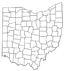
Bridgetown North was a census-designated place (CDP) in Hamilton County, Ohio, United States. The population was 12,569 at the 2000 census. Its name was listed as Bridgetown for the 2010 census.

Reiffton is a census-designated place (CDP) in Exeter Township, Berks County, Pennsylvania, United States. The population was 4,178 at the 2010 census.

Nixon is a census-designated place (CDP) in Butler County, Pennsylvania, United States. The population was 1,373 at the 2010 census.

Ipswich is a census-designated place (CDP) located in the town of Ipswich in Essex County, Massachusetts, United States. The population was 4,222 at the 2010 census.

