
New England or New England North West is the name given to a generally undefined region in the north of the state of New South Wales, Australia about 60 kilometres (37 miles) inland, that includes the Northern Tablelands and the North West Slopes regions.

Tenterfield is a town in New South Wales, Australia. It is located in the New England region at the intersection of the New England Highway and the Bruxner Highway. Tenterfield is a three-hour drive from Brisbane, Queensland, three hours from Byron Bay, New South Wales, two hours from Armidale, New South Wales and eight hours from Sydney. The town is on the north-western part of the Northern Tableland plateau, nestled in a valley, astride the Great Dividing Range and beneath the imposing Mount MacKenzie, one of the highest points along the Northern Tablelands. At the 2016 census, Tenterfield had a population of approximately 4,000.
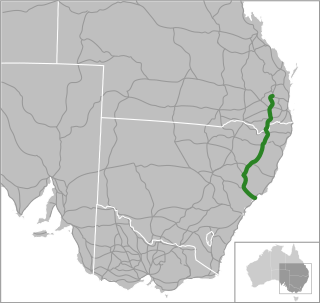
The New England Highway is an 878-kilometre (546 mi) long highway in Australia running from Hexham at Newcastle, New South Wales at its southern end to Yarraman, north of Toowoomba, Queensland at its northern end. It is part of Australia's National Highway system, and forms part of the inland route between Brisbane and Sydney.

The Mount Lindesay Highway is an Australian national highway located in Queensland, also known as National Route 13. The highway runs southwest from Brisbane, where it leaves Ipswich Road in the suburb of Moorooka, to the Queensland – New South Wales border and is approximately 116 kilometres (72 mi) in length. For most of its length it is roughly aligned with the Sydney–Brisbane rail corridor. At its southern end these transport routes take different passes over the Scenic Rim into the Northern Rivers region.

The Main North Line is a major railway in New South Wales, Australia. It runs through the Central Coast, Hunter and New England regions. The line was the original main line between Sydney and Brisbane, however this required a change of gauge at Wallangarra. As of 1988, the line is now closed north of Armidale, with the main route between Sydney and Brisbane now the North Coast line.

Jennings is a town on the Northern Tablelands region of New South Wales, Australia. The town is located in the Tenterfield Shire local government area, 718 kilometres (446 mi) from the state capital, Sydney and 256 kilometres (159 mi) from Brisbane. It is separated by the state border from its neighbouring town of Wallangarra in Queensland. At the 2011 census, Jennings had a population of 211. The New England Highway and the Main North railway line cross the state border at Jennings. The town was named for Sir Patrick Jennings, the first Roman Catholic Premier of New South Wales.
The Maryvale railway line was a branch railway in the Southern Downs region of Queensland, Australia.

The Southern railway line serves the Darling Downs region of Queensland, Australia. The 197 kilometre long line branches from the Western line at Toowoomba, 161 kilometres west of Brisbane, and proceeds south through Warwick and Stanthorpe to the New South Wales/Queensland state border at Wallangarra.

Queensland's railway construction commenced in 1864, with the turning of the first sod of the Main Line by Lady Diamantina Bowen, the wife of Queensland's first governor Sir George Bowen at Ipswich, Queensland, Australia. A narrow gauge of 3 ft 6 in was selected due to cost savings in providing a rail link to Toowoomba. Despite being built with bridges wide enough for standard gauge, and the fact that most other lines did not require heavy earthworks, the gauge remained the Queensland system norm.

The Northern Tablelands Express is an Australian passenger train operated by the New South Wales Government Railways and its successors since June 1941.

A Travelling Post Office (TPO) is a postal receiving, sorting and delivery service situated on a train, usually in a specially designated carriage that is part of a passenger train. In Queensland, Australia, the service was provided from 1877 to 1932.

Wallangarra railway station is a heritage-listed railway station at Woodlawn Street, Wallangarra, Southern Downs Region, Queensland, Australia. It was built in 1877 along the state border of Queensland and New South Wales It was added to the Queensland Heritage Register on 28 March 2003.

State Strategic Touring Routes (SSTR) are road routes in Queensland, Australia, which have been identified as significant to motoring tourists. These are the primary routes used by tourists as they provide the connections between popular tourist locations, and consequently have high volumes of tourist traffic. Standardised road signage is used to identify the route itself, with "Welcome to" signage at towns and districts of interest to tourists, as well as "turn off" signage to natural attractions.
The Capricorn Way is an Australian road route from Rockhampton to Barcaldine in Queensland. Using the Capricorn Way, it is 579.67 km (360.19 mi) from Rockhampton to Barcaldine. The recommended journey time, allowing for some sightseeing, food and rest is 30 hours. It has been designated by the Queensland Government as a State Strategic Touring Route.
The Leichhardt Way is an Australian road route from Melbourne, Victoria to Rockhampton in Queensland. It has been designated by the Queensland Government as a State Strategic Touring Route.
The Pacific Coast Way is an Australian road route from Sydney, New South Wales to Cairns in Queensland. It has been designated by the Queensland Government as a State Strategic Touring Route.
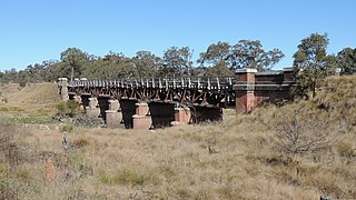
The Tenterfield Creek railway bridge is an heritage-listed former railway bridge that carried the Main North line across the Tenterfield Creek from Sunnyside to Jennings, bothin the Tenterfield Shire local government area of New South Wales, Australia. It was designed by John Whitton and Engineer-in-Chief for NSW Government Railways and built in 1888. The bridge is also known as the Sunnyside rail bridge over Tenterfield Creek. The property is owned by RailCorp, an agency of the Government of New South Wales and was added to the New South Wales State Heritage Register on 2 April 1999.


