Related Research Articles

Bukit Timah, often abbreviated as Bt Timah, is a planning area and residential estate located in the westernmost part of the Central Region of Singapore. Bukit Timah lies roughly 10 kilometres (6.2 mi) from the Central Business District, bordering the Central Water Catchment to the north, Bukit Panjang to the northwest, Queenstown to the south, Tanglin to the southeast, Clementi to the southwest, Novena to the east and Bukit Batok to the west.
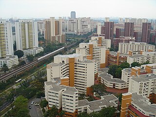
Bukit Batok, often abbreviated as Bt Batok, is a planning area and matured residential town located along the eastern boundary of the West Region of Singapore. Bukit Batok statistically ranks in as the 25th largest, the 12th most populous and the 11th most densely populated planning area in the Republic. It is bordered by six other planning areas - Choa Chu Kang to the North, northeast and northwest, Cashew to the northeast and east, Clementi to the south, Bukit Timah to the southeast, Jurong East to the southwest and Tengah to the west.

Queenstown is a planning area and satellite residential town situated on the south-westernmost fringe of the Central Region of Singapore. It borders Bukit Timah to the north, Tanglin to the northeast, Bukit Merah to the east and southeast, as well as Clementi to the northwest and west. Its southern and southwesternmost limits are bounded by the Pandan Strait.

The Royal Malay Regiment is the premier unit of the Malaysian Army's two infantry regiments. At its largest, the Malay Regiment comprised 27 battalions. At present, three battalions are parachute trained and form part of the Malaysian Army Rapid Deployment Force. Another battalion has been converted into a mechanised infantry battalion while the remaining battalions are standard light infantry. The 1st Battalion Royal Malay Regiment acts as the ceremonial foot guards battalion for the Yang di-Pertuan Agong, and is usually accompanied by the Central Band of the Royal Malay Regiment. As its name suggests, the regiment only recruits ethnic Malays.

The Battle of Pasir Panjang, which took place between 12 and 15 February 1942, was part of the final stage of the Empire of Japan's invasion of Singapore during World War II. The battle was initiated upon the advancement of elite Imperial Japanese Army forces towards Pasir Panjang Ridge on 13 February.

Pasir Panjang MRT station is an underground Mass Rapid Transit (MRT) station on the Circle line. As the name suggests, it is located in Pasir Panjang at the southern part of Queenstown planning area, Singapore. This station is situated underneath Pasir Panjang Road and Labrador Viaduct, next to the Pasir Panjang Food Centre, Currency House and Pasir Panjang container terminal. It is also near the Reflections at Bukit Chandu, a museum near the site of the Battle of Pasir Panjang.

Mount Faber, formerly Telok Blangah Hill, is a hill about 94 metres (308 ft) in height, located in the town of Bukit Merah in the Central Region of Singapore. It overlooks the Telok Blangah area, and the western parts of the Central Area. The summit is accessible by Mount Faber Road or Mount Faber Loop via Morse Road, but there are many footpaths or trails leading up the hill. The main paths are: Marang Trail which leads from Marang Road at the Harbourfront MRT station and the Southern Ridges Park Connector which connects from Telok Blangah Hill Park, Kent Ridge Park and Henderson Waves.

The Former Ford Factory is located along Upper Bukit Timah Road at Bukit Timah in Singapore. It is the place where the British Army forces surrendered to Imperial Japanese Army forces on 15 February 1942 after the Battle of Singapore. The Old Ford Motor Factory had since been gazetted as a National Monument in 2006, and converted into an exhibition gallery and archive named Memories at Old Ford Factory. The permanent exhibition gallery showcases life in Singapore under Japanese wartime rule, and the exhibition is one of the continuation of final battles from Pasir Panjang and at Fort Siloso.

The 1st Malaya Infantry Brigade was a regular infantry brigade formed in 1939 with its headquarters in Singapore immediately after the outbreak of hostilities in Europe. The Brigade participated in the Battle of Singapore against the Japanese until the surrender of the garrison in February 1942.
The National Heritage Board (NHB) is a statutory board under the Ministry of Culture, Community and Youth (MCCY) of the Government of Singapore. It was formed on 1 August 1993.

Poh Ern Shih is located on a small hilltop at Chwee Chian Road, off Pasir Panjang Road, on Singapore's southern coast. The Buddhist temple was built as a memorial to those who lost their lives during the Battle of Pasir Panjang in 1942, villagers as well as Allied and Japanese soldiers. The temple's first abbot, Sumangalo, an American Theravadin monk, was the first Westerner to be appointed abbot of a Buddhist temple in Singapore.

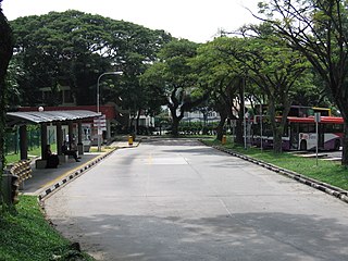
Kent Ridge Park is a 47-hectare public park located in Kent Ridge, Singapore, between the National University of Singapore and the Singapore Science Park. Due to its undisturbed habitat and abundant plant life, it is a popular venue for bird-watchers and eco-tourists.

The Battle of Kranji was the second stage of the Empire of Japan's plan for the invasion of Singapore during the Second World War. On 9 February 1942 the Imperial Japanese Army assaulted the north-western front of Singapore, capital of the Straits Settlements.

The Southern Ridges comprise 10 kilometres (6.2 mi) of trails connecting three parks along the southern ridge of Singapore. Some of the attractions along these trails include its greenery and the connecting bridges. This project linked up the parks between the Kent Ridge Park and HarbourFront. The idea to link these parks was coined in 2002 by Urban Redevelopment Authority (URA) and it took 2 years to complete and cost S$25.5 million.
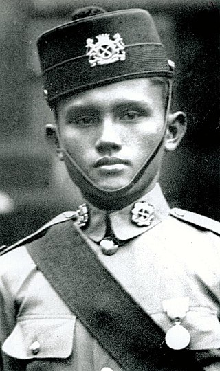
Adnan bin Saidi was a Malayan military officer of the 1st Infantry Brigade who fought the Japanese at the Battle of Pasir Panjang in Singapore during World War II. He is lauded as a national hero in Singapore and Malaysia for his actions during the battle. His name has been given to the Malaysian Infantry Fighting Vehicle (MIFV).

Telok Blangah Hill Park is a park situated at Telok Blangah Green, off Henderson Road, in Bukit Merah. It connects Mount Faber Park via Henderson Waves Bridge. Standing at 36m (118ft) above Henderson Road, it is the tallest pedestrian bridge in Singapore. Henderson Waves is renowned for its artistic, distinctive wave-like structure consisting of a series of undulating curved 'ribs'.

Reflections at Bukit Chandu is a World War II interpretive centre developed and managed by the National Archives of Singapore, located on Bukit Chandu off Pasir Panjang Road in Singapore.
Noorhaqmal Mohamed Noor(b. 1984) – also known as Aqmal N., is a Singaporean singer, musician, composer and producer. His song, "Warkah Cinta Dunia" (2009) has been distributed worldwide in internet websites such as Amazon, Rhapsody, iTunes, Napster, eMusic, SonicTap, ShockHound, Spotify, iMesh and Nokia.
Kent Ridge is the name of a ridge and a neighbourhood located in Pasir Panjang, in the Queenstown Planning Area of Singapore. The area is notable for housing two parks within the Southern Ridges, Kent Ridge Park and HortPark. The main campus of the National University of Singapore is located adjacent to it, straddling along the southern boundary of Kent Ridge. It is served by the Kent Ridge MRT station.