The Logan River is a perennial river in the Scenic Rim, Logan and Gold Coast local government areas of the South East region of Queensland, Australia. The 184-kilometre (114 mi)-long river is one of the dominant waterways in South East Queensland that drains the southern ranges of the Scenic Rim and empties into Moreton Bay after navigating the City of Logan, a major suburban centre located south of Brisbane. The catchment is dominated by urban and agricultural land use. Near the river mouth are mangrove forests and a number of aquaculture farms.
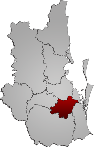
The City of Logan is a local government area (LGA) located in the south of Greater Brisbane in South East Queensland (SEQ), Australia. Situated between the City of Brisbane to the north and the City of Gold Coast to the south, the City of Logan also borders the Scenic Rim Region, the City of Ipswich, and Redland City LGAs. Logan is divided into 70 suburbs and 12 divisions; a councillor is elected to each of the latter. The council had a population of 326,615 as of June 2018.

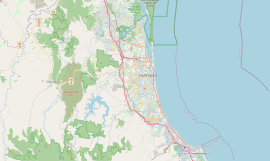
Beenleigh is a town and suburb in the City of Logan, Queensland, Australia. In the 2021 census, the suburb of Beenleigh had a population of 8,425 people.

Bethania is a suburb in the City of Logan, Queensland, Australia. In the 2021 census, Bethania had a population of 6,333 people.
The Shire of Albert was a local government area in Queensland, located south of the capital, Brisbane, and taking in areas to the north and west of the Gold Coast. It was named after the Prince Consort of the United Kingdom, and husband of Queen Victoria, Prince Albert. When created in 1948, it was primarily a rural area, but its growth started in earnest in the late 1960s with the development of Logan on Brisbane's southern frontier. After the separate creation of Logan as a shire in 1978, Albert lost most of its population and became more centred upon the Gold Coast, which experienced a massive period of growth from then until the Shire's amalgamation with the City of Gold Coast in 1995.

Logan Village is a semi-rural town and locality in the City of Logan, Queensland, Australia. Logan Village was once known as the head of the navigable Logan River. Its importance as a town grew again when the railway arrived.

Munruben is a rural locality in the City of Logan, Queensland, Australia. Once a rural community, it has been developed into a low density residential community. In the 2021 census, Munruben had a population of 2,753 people.

The Beaudesert railway line is a disused branch railway in South East Queensland, Australia. The first section opened in 1885, the line was completed in 1888 and operated as a Queensland Government Railways (QGR) line until 1996. A heritage operation was undertaken for a short period in 2003. The Canungra railway line connected at Logan Village between 1915 and 1955, and the Beaudesert Shire Tramway connected with the terminal between 1903 and 1944. A study was undertaken in 2010 by the Queensland government concerning a potential Salisbury-to-Beaudesert rail corridor as a long-term potential proposal.

Clagiraba is a rural locality in the City of Gold Coast, Queensland, Australia. In the 2021 census, Clagiraba had a population of 651 people.

Mount Warren Park is a residential suburb in the outer eastern area of the City of Logan, Queensland, Australia. The mountain of Mount Warren is within the suburb.

Buccan is a rural locality in the City of Logan, Queensland, Australia. In the 2021 census, Buccan had a population of 2,134 people.
Alberton is a rural locality in the City of Gold Coast, Queensland, Australia. In the 2021 census, Alberton had a population of 547 people.

Wonglepong is a rural locality in the Scenic Rim Region, Queensland, Australia. In the 2021 census, Wonglepong had a population of 364 people.
Lower Beechmont is a locality in the City of Gold Coast, Queensland, Australia. It is situated in the Gold Coast hinterland. In the 2021 census, Lower Beechmont had a population of 1,067 people.
Wolffdene is a rural locality in the City of Logan, Queensland, Australia. In the 2021 census, Wolffdene had a population of 266 people.

Luscombe is a rural locality in the City of Gold Coast, Queensland, Australia. In the 2021 census, Luscombe had a population of 265 people.

Wongawallan is a rural locality in the City of Gold Coast, Queensland, Australia. In the 2021 census, Wongawallan had a population of 1,415 people.

Tamborine is a rural town in the Scenic Rim Region and a locality split between the Scenic Rim Region and the City of Logan in Queensland, Australia. In the 2021 census, the locality of Tamborine had a population of 4,388 people.
Beaudesert–Beenleigh Road is a continuous 35.5 kilometres (22.1 mi) road route in the Scenic Rim and Logan City regions of Queensland, Australia. Part of the road is signed as State Route 90 and the rest as State Route 92. Beaudesert–Beenleigh Road is a state-controlled road, part district and part regional.
The Tamborine Mountain road network is a group of roads that provide access to the mountain community from various lowland localities. The network ensures continuity of access in times of flooding or other natural disasters, and during planned maintenance activities. The locality of Tamborine Mountain includes a plateau that hosts a substantial residential community plus many tourism accommodation and activity venues.