Mount Hector is a 3,394-metre (11,135-foot) mountain summit located in the Bow River valley of Banff National Park, in the Canadian Rockies of Alberta, Canada. The mountain was named in 1884 by George M. Dawson after James Hector, a geologist on the Palliser expedition. The mountain is located beside the Icefields Parkway, 17 km (11 mi) north of Lake Louise.

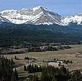
Mount Coulthard is a mountain straddling the border between Alberta and British Columbia in Canada. It is part of the Flathead Range which is a subset of the Canadian Rockies. The mountain is set on the Continental Divide, in Castle Wildland Provincial Park. It is situated in the Crowsnest Pass area and can be seen from Highway 3, the Crowsnest Highway.

Haddo Peak is a summit in Alberta, Canada. Haddo Peak is located in the Lake Louise area of Banff National Park.

Mount Wilson is a 3,260-metre (10,696 ft) mountain summit located in the North Saskatchewan River valley of Banff National Park, in the Canadian Rockies of Alberta, Canada. Its nearest higher peak is Mount Cline, 9.81 km (6.10 mi) to the northeast. Mount Wilson is situated immediately north of the confluence of the North Saskatchewan River, Mistaya River, and Howse River near Saskatchewan Crossing, where the Icefields Parkway intersects with the David Thompson Highway.

Mount Murchison is a 3,348-metre (10,984 ft) mountain summit located at the convergence of the North Saskatchewan River valley and Mistaya River valley of Banff National Park, in the Canadian Rockies of Alberta, Canada. The main summit has two high points: the Southeast Peak is 3,348 m, whereas the Northwest Peak is 3,333 m and separated by 700 m distance. Its nearest higher peak is Mount Cline, 15.71 km (9.76 mi) to the north. Mount Murchison is situated immediately southeast of the confluence of the North Saskatchewan River, Mistaya River, and Howse River near Saskatchewan Crossing, where the Icefields Parkway intersects with the David Thompson Highway.
Nigel Peak is a 3,211-metre (10,535-foot) mountain summit located on the shared border of Banff National Park and Jasper National Park, in the Canadian Rockies of Alberta, Canada. Nigel has two peaks, the north summit is the highest point. The nearest higher peak is Mount Athabasca, 6.4 km (4.0 mi) to the south-southwest. Nigel Peak is situated immediately north of Sunwapta Pass and can be seen from the Icefields Parkway and from Athabasca Glacier. Topographic relief is significant as the summit rises 1,100 metres (3,609 ft) above the parkway in two kilometres (1.2 mile).
Bow Peak is a 2,840-metre (9,320-foot) mountain summit located in the Bow River valley of Banff National Park, in the Canadian Rockies of Alberta, Canada. Its nearest higher peak is Crowfoot Mountain, 2.11 km (1.31 mi) to the east. Bow Peak is situated north of Hector Lake, southeast of Bow Lake, and can be seen from the Icefields Parkway. Although not of remarkable elevation, the mountain is a conspicuous landmark and visible from as far away as the Lake Louise area. Its position in the Waputik Mountains provides magnificent views from the summit.

Mount Nestor is a 2,970-metre (9,740 ft) mountain summit located in Kananaskis Country in the Canadian Rockies of Alberta, Canada. It is named after HMS Nestor, a destroyer sunk in the Battle of Jutland during World War I. Mount Nestor is situated at the south end of the Goat Range along the west shore of Spray Lakes Reservoir. Nestor's east flank is within Spray Valley Provincial Park, while the west aspect is within Banff National Park, with the boundary line between the two parks running roughly north-to-south over its summit. The nearest higher peak is Old Goat Mountain, 2.0 km (1.2 mi) to the north. Mount Nestor can be seen from Alberta Highway 742, the Smith-Dorrien/Spray Trail.
Old Goat Mountain is a 3,120-metre (10,240 ft) mountain summit located in Kananaskis Country of Alberta, Canada.

Commonwealth Peak is a 2,775-metre (9,104-foot) mountain summit in the Spray Mountains, a sub-range of the Canadian Rockies in Alberta, Canada. The mountain is situated in Peter Lougheed Provincial Park. Its nearest higher peak is Mount Birdwood, 1.0 km (0.62 mi) to the west. Both can be seen from Alberta Highway 742, also known as Smith-Dorrien/Spray Trail in Kananaskis Country.

Watermelon Peak is a 3,095-metre (10,154-foot) summit located in Banff National Park, in the Canadian Rockies of Alberta, Canada. Its nearest higher peak is Deluc Peak, 13.5 km (8.4 mi) to the east.

Marvel Peak is a 2,708-metre (8,885-foot) mountain summit located in the southern tip of Banff National Park, in the Canadian Rockies of Alberta, Canada. Marvel Peak is situated in the Blue Range, three kilometers from the Continental Divide, and not visible from any road. Marvel Peak's nearest higher peak is Wonder Peak, 3.29 km (2.04 mi) to the north-northwest.

Mount Tecumseh is a 2,547-metre-high (8,356 ft) mountain summit located in the Canadian Rockies of Alberta, Canada.

Seven Sisters Mountain is a 2,591-metre-high (8,501 ft) mountain summit located in the Canadian Rockies of Alberta, Canada.

Sentry Mountain is a 2,435-metre (7,989-foot) summit located in the Canadian Rockies of Alberta, Canada.

Mystic Peak is a mountain summit in the Canadian Rockies of Alberta, Canada.
Mount McLaren is a 2,301-metre (7,549-foot) mountain summit located in Alberta, Canada.
Mount Parrish is a 2,530-metre (8,301-foot) mountain summit located in Alberta, Canada.

Mount Mercer is a 2,970-metre (9,744-foot) mountain summit located in Alberta, Canada.

Mount Head is a 2,782-metre (9,127-foot) mountain summit located in Alberta, Canada.