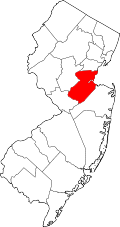
Colonia, New Jersey | |
---|---|
Coordinates: 40°35′39″N74°18′50″W / 40.594133°N 74.31377°W | |
Country | United States |
State | New Jersey |
County | Middlesex |
Township | Woodbridge |
Area | |
• Total | 4.03 sq mi (10.45 km2) |
• Land | 4.03 sq mi (10.44 km2) |
• Water | 0.00 sq mi (0.01 km2) 0.11% |
Elevation | 69 ft (21 m) |
Population | |
• Total | 18,609 |
• Density | 4,617.62/sq mi (1,782.99/km2) |
Time zone | UTC−05:00 (Eastern (EST)) |
• Summer (DST) | UTC−04:00 (Eastern (EDT)) |
ZIP Code | 07067 [4] |
Area code(s) | 732/848 |
FIPS code | 34-14380 [5] [6] [7] |
GNIS feature ID | 02389346 [5] [8] |
Colonia is an unincorporated community and census-designated place (CDP) [9] in Woodbridge Township, Middlesex County, New Jersey, United States. [10] [11] As of the 2020 United States census, the CDP's population was 18,609. [3]
In 1919, the New Jersey State Highway Commission built a new road that became part of the Lincoln Highway, an early plan to create a transcontinental highway. The stretch was constructed on the west side of the Pennsylvania Railroad (now the Northeast Corridor) from near the northeast of Dow Avenue between Colonia and Iselin to Cedar Street in Menlo Park, to avoid two railroad crossings. The old road is now Middlesex-Essex Turnpike and Thornall Street, on the east side of the tracks.
Colonia is in northeastern Middlesex County, in the northwest corner of Woodbridge Township. It is bordered to the north by Clark, to the northeast by Rahway, to the east by Avenel, to the south by Iselin, and to the west by Edison. Union County borders the community to the north and northeast. Newark is 13 miles (21 km) to the northeast, and New Brunswick, the Middlesex county seat, is 11 miles (18 km) to the southwest.
According to the U.S. Census Bureau, the Colonia CDP has a total area of 4.034 square miles (10.45 km2), including 0.004 square miles (0.010 km2) of water (0.10%). [1] The community is drained to the northeast by the South Branch of the Rahway River, part of the watershed of the Arthur Kill. Colonia has a humid subtropical climate (Cfa) and average monthly temperatures range from 33 °F (1 °C) in January to 78.1 °F (25.6 °C) in July. [12]
The Garden State Parkway passes through the western portion of the CDP but does not interchange there. For northbound Garden State Parkway traffic only there is a service plaza in Colonia; it is the parkway's only area located on private property. [13]
In 2018 the president of the Historical Association of Woodbridge, Daniel D'Arcy, stated that "Colonia is to Woodbridge like the Bronx is to NYC. People like the identity." [14]
Census | Pop. | Note | %± |
---|---|---|---|
1990 | 18,238 | — | |
2000 | 17,811 | −2.3% | |
2010 | 17,795 | −0.1% | |
2020 | 18,609 | 4.6% | |
Population sources: 1990-2010 [10] 2000 [15] 2010 [16] 2020 [3] |
The 2010 United States census counted 17,795 people, 6,160 households, and 4,977 families in the CDP. The population density was 4,551.4 people per square mile (1,757.3 people/km2). There were 6,321 housing units at an average density of 1,616.7 units per square mile (624.2 units/km2). The racial makeup was 80.37% (14,302) White, 5.26% (936) Black or African American, 0.12% (21) Native American, 10.70% (1,904) Asian, 0.04% (8) Pacific Islander, 1.54% (274) from other races, and 1.97% (350) from two or more races. Hispanic or Latino of any race were 9.27% (1,649) of the population. [16]
Of the 6,160 households, 34.8% had children under the age of 18; 65.6% were married couples living together; 11.3% had a female householder with no husband present and 19.2% were non-families. Of all households, 16.4% were made up of individuals and 8.9% had someone living alone who was 65 years of age or older. The average household size was 2.89 and the average family size was 3.25. [16]
22.8% of the population were under the age of 18, 7.5% from 18 to 24, 24.4% from 25 to 44, 30.0% from 45 to 64, and 15.3% who were 65 years of age or older. The median age was 42.3 years. For every 100 females, the population had 93.2 males. For every 100 females ages 18 and older there were 90.6 males. [16]
As of the 2000 United States Census [6] there were 17,811 people, 6,184 households, and 5,077 families residing in the CDP. The population density was 1,772.4 people/km2 (4,590 people/sq mi). There were 6,254 housing units at an average density of 622.3 units/km2 (1,612 units/sq mi). The racial makeup of the CDP was 86.00% White, 4.76% African American, 0.10% Native American, 6.31% Asian, 0.06% Pacific Islander, 1.27% from other races, and 1.50% from two or more races. Hispanic or Latino of any race were 4.97% of the population. [15]
There were 6,184 households, out of which 35.0% had children under the age of 18 living with them, 68.7% were married couples living together, 10.3% had a female householder with no husband present, and 17.9% were non-families. 15.2% of all households were made up of individuals, and 8.7% had someone living alone who was 65 years of age or older. The average household size was 2.88 and the average family size was 3.21. [15]
In the CDP the population was spread out, with 23.7% under the age of 18, 6.2% from 18 to 24, 29.1% from 25 to 44, 24.8% from 45 to 64, and 16.2% who were 65 years of age or older. The median age was 40 years. For every 100 females, there were 93.0 males. For every 100 females age 18 and over, there were 88.4 males. [15]
The median income for a household in the CDP was $67,372, and the median income for a family was $76,090. Males had a median income of $50,260 versus $36,657 for females. The per capita income for the CDP was $27,732. About 1.5% of families and 2.2% of the population were below the poverty line, including 2.0% of those under age 18 and 4.0% of those age 65 or over. [15]
Merrill Park is a Middlesex County park located on the South Branch of the Rahway River. The park was created as a "Progressive Playground" and spans 179 acres (72 ha). The park's maintenance is handled by funding from the municipality, local schools, community groups and local businesses. Merrill Park includes four tennis courts, three baseball fields, a soccer field, seven picnic groves that can be reserved in advance, the progressive playground, a football field, two basketball courts, two softball fields, two open picnic groves, and three other playgrounds. The football field and soccer field are surrounded by a walkway for joggers as well. There are numerous small trails around the park. [17]
Schools in Colonia operated as part of the Woodbridge Township School District are:
Elementary schools (K-5)
Middle school (6th-8th)
High school (9th-12th)
People who were born in, residents of, or otherwise closely associated with Colonia include:
Middlesex County is a county located in the north-central part of the U.S. state of New Jersey, extending inland from the Raritan Valley region to the northern portion of the Jersey Shore. As of the 2020 United States census, the county was the state's third-most populous county with a population of 863,162, its highest decennial count ever and an increase of 53,304 (+6.6%) from the 2010 census count of 809,858, which in turn reflected an increase of 59,696 (8.0%) from the 750,162 counted in the 2000 census. Middlesex is part of the New York metropolitan area. Many communities within the county serve as commuter towns to and from New York City and other points north. The county is part of the Central Jersey region of the state.
Cape May Court House is an unincorporated community and census-designated place (CDP) located within Middle Township in Cape May County, in the U.S. state of New Jersey. It is part of the Ocean City metropolitan statistical area. As of the 2020 United States census, the CDP's population was 5,573, reflecting a 4.4% increase from the 5,338 enumerated at the 2010 U.S. census, in turn an increase of 13.5% from the 4,704 counted in the 2000 census. It is the county seat of Cape May County and serves as the principal administrative hub for the township. It constitutes part of the greater Philadelphia metropolitan area, or the Delaware Valley.
Whitehouse Station, also spelled White House Station, is an unincorporated community and census-designated place (CDP) located within Readington Township, in Hunterdon County, New Jersey. At the 2010 United States Census, the CDP's population was 2,089. Whitehouse Station takes its name from Whitehouse and Abraham Van Horne's 18th century tavern.
Avenel is an unincorporated community and census-designated place (CDP) located within Woodbridge Township, in Middlesex County, in the U.S. state of New Jersey. Avenel is approximately 25 miles (40 km) southwest of Midtown Manhattan along the North Jersey Coast rail line
Fords is a census-designated place (CDP) in Woodbridge Township, Middlesex County, New Jersey, in the United States. As of the 2020 census, the CDP's population was 12,941.
Iselin is an unincorporated community and census-designated place (CDP) located within Woodbridge Township, in Middlesex County, in the U.S. state of New Jersey. As of the 2020 United States census, Iselin's population was 20,088, up from 18,695 in 2010.
Kendall Park is an unincorporated community and census-designated place (CDP) in South Brunswick Township, Middlesex County, New Jersey, United States. As of the 2020 census, the CDP's population was 9,989, up from 9,339 in 2010. Kendall Park has a post office with its own ZIP Code (08824) that encompasses the majority of the CDP, as well as some surrounding areas.
Kingston is an unincorporated community and census designated place (CDP) along the border of South Brunswick Township in Middlesex County and Franklin Township in Somerset County, and also located relatively near Princeton in Mercer County in the U.S. state of New Jersey. The historic settlement is in the Raritan Valley region, located along the course of the Millstone River. As of the 2020 census, the CDP's population was 1,581, of which 1,272 were in South Brunswick Township and 309 in Franklin Township.
Laurence Harbor is an unincorporated community and census-designated place (CDP) located along Raritan Bay within Old Bridge Township, Middlesex County, New Jersey, United States. As of the 2020 United States census, the CDP's population was 6,635, an increase of 99 (+1.5%) from the 6,536 recorded at the 2010 census, which in turn reflected an increase of 309 (+5.0%) from the 6,227 counted in the 2000 census.
Metuchen is a suburban borough in Middlesex County in the U.S. state of New Jersey. The borough is a commuter town of New York City, located in the heart of the Raritan Valley region within the New York Metropolitan area. The borough, along with Edison, is a regional commercial hub for Central New Jersey. The borough is 6 miles (9.7 km) northeast of New Brunswick, 17 miles (27 km) southwest of Newark, 20 miles (32 km) southwest of Jersey City, and 22 miles (35 km) southwest of Manhattan. As of the 2020 United States census, the borough's population was 15,049, an increase of 1,475 (+10.9%) from the 2010 census count of 13,574, which in turn reflected an increase of 734 (+5.7%) from the 12,840 counted in the 2000 census.
Old Bridge is a census-designated place (CDP) in Old Bridge Township, Middlesex County, New Jersey, United States. As of the 2020 census, the CDP's population was 27,210, up from 23,753 in 2010. The Old Bridge CDP occupies only a portion of Old Bridge Township.
Port Reading is an unincorporated community and census-designated place (CDP) in Woodbridge Township, Middlesex County, New Jersey, United States. As of the 2020 census, the population was 3,921.
Sewaren is an unincorporated community and census-designated place (CDP) within Woodbridge Township, Middlesex County, New Jersey, United States. As of the 2020 census, the CDP's population was 2,885.
Woodbridge is an unincorporated community and census-designated place (CDP) within Woodbridge Township, in Middlesex County, New Jersey, United States. As of the 2020 census, the CDP's population was 19,839, out of 103,639 in all of Woodbridge Township. Despite the similarity in the name of the CDP and the township, the two are not coextensive; the CDP occupies 15.7% of the township's 24.51 square miles (63.5 km2).
Woodbridge Township is a township in northern Middlesex County, in the U.S. state of New Jersey. The township is a regional hub of transportation and commerce for central New Jersey and a major bedroom suburb of New York City, within the New York metropolitan area. Located within the core of the Raritan Valley region, Woodbridge Township hosts the junction of the New Jersey Turnpike and the Garden State Parkway, the two busiest highways in the state, and also serves as the headquarters for the New Jersey Turnpike Authority, which operates both highways.
Navesink is an unincorporated community and census-designated place (CDP) located on the northernmost stretch of the Jersey Shore in Middletown Township in Monmouth County, in the U.S. state of New Jersey. As of the 2020 United States census, the CDP's population was 2,004, reflecting a decrease of 16 (-0.8%) from thd 2,020 residents enumerated at the 2010 U.S. census.
Forked River is an unincorporated community and census-designated place (CDP) located within Lacey Township, in Ocean County, in the U.S. state of New Jersey. As of the 2020 United States census, the CDP's population was 5,274, an increase of 30 (+0.6%) from the 5,244 enumerated at the 2010 census, which in turn reflected an increase of 330 (+6.7%) from the 4.914 counted in the 2000 census.
Menlo Park Terrace is an unincorporated community and census-designated place (CDP) in Woodbridge Township, Middlesex County, New Jersey, United States. As of the 2020 census, its population was 2,806.
Keasbey is a census-designated place (CDP) and unincorporated community in Woodbridge Township, Middlesex County, New Jersey, United States. It is located in the western outskirts of adjacent Perth Amboy. As of the 2020 census, the CDP's population was 3,027. Many Hispanic / Latino families have relocated from Perth Amboy to Keasbey.
Franklin Park is an unincorporated community and census-designated place (CDP) located within Franklin Township, in Somerset County, in the U.S. state of New Jersey. As of the 2010 United States Census, the CDP's population was 13,295. Route 27 bisects the village and serves as the dividing line between the two counties. The adjacent sections of South Brunswick and North Brunswick, Middlesex County on the east side of Route 27 are also known as Franklin Park, but are not included within the CDP's boundaries.