Related Research Articles

The Division of Hume is an Australian electoral division in the state of New South Wales.

The Goulburn Valley is a sub-region, part of the Hume region of the Australian state of Victoria. The sub-region consists of those areas in the catchment of the Goulburn River and other nearby streams, and is part of the Murray-Darling Basin. The Goulburn Valley is bordered on the south by the Great Dividing Range and to the north by the Murray River, the state border with New South Wales. The sub-region is one of Australia's most productive and intensively farmed areas and is predominantly irrigated.

Monaro, also known as Maneroo (1856–1858), Monara (1858–1879) and Manaro (1894–1904) is an electoral district of the Legislative Assembly in the Australian state of New South Wales. It is currently represented by Steve Whan of the Labor party since the 2023 New South Wales state election.

The Electoral district of Rodney was a Victorian Legislative Assembly electorate in Northern Victoria.

Goulburn is an electoral district of the Legislative Assembly in the Australian state of New South Wales. It is represented by Wendy Tuckerman of the Liberal Party.

Argyle was an electoral district for the Legislative Assembly in the Australian State of New South Wales from 1856 to 1904, including Argyle County surrounding Goulburn. The town of Goulburn was in Southern Boroughs from 1856 to 1859 and then Goulburn. The district had previously been represented by the district of County of Argyle in the partially elected Legislative Council.
Southern Boroughs was an electoral district for the Legislative Assembly in the Australian state of New South Wales created in 1856. It included the towns of Goulburn, Braidwood, Yass and Queanbeyan, while the surrounding rural area were in the electoral districts of Argyle, United Counties of Murray and St Vincent and King and Georgiana. It was replaced by Goulburn, Braidwood, Queanbeyan and Yass in 1859.

The electoral district of Shepparton is a rural Lower House electoral district of the Victorian Parliament. It is located within the Northern Victoria Region of the Legislative Council.
The Electoral district of Numurkah and Nathalia was an electoral district of the Victorian Legislative Assembly. It was created by the Electoral Act Amendment Act 1888, taking effect at the 1889 elections. It was abolished by the Victorian Electoral Districts Boundaries Act 1903 (taking effect at the 1904 elections) when several new districts were created.
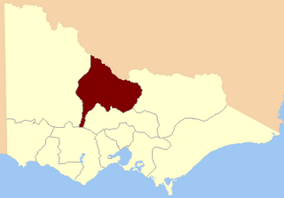
The Electoral district of Goulburn Valley was an electoral district of the Victorian Legislative Assembly. The district was replaced by the district of Goulburn in 1945.
Goulburn, an electoral district of the Legislative Assembly in the Australian state of New South Wales, has had two incarnations, from 1859 until 1991 and from 2007 to the present.

The Murray was an electoral district of the Legislative Assembly in the Australian colony of Victoria from 1856 to 1877.

The Electoral district of Murray was one of the sixteen electoral districts of the original unicameral Victorian Legislative Council of 1851 to 1856.

Dalhousie was an electoral district of the Legislative Assembly in the Australian state of Victoria from 1859 to 1927. It was based in north-western Victoria. The district had been named Electoral district of Anglesey. The district of Dalhousie was defined in the 1858 Electoral Act as :
THE ELECTORAL DISTRICT OF DALHOUSIE.
ANGLESEY. Bounded on the west by part of the eastern boundary of the County of Dalhousie, namely, by the River Goulburn from the confluence of Hughes's Creek to the confluence of Dabyminga Creek; thence by Dabyminga Creek to its source in the Great Dividing Range; on the south by the Great Dividing Range to the main source of the River Goulburn; on the east by the range dividing the waters of the main source of the Goulburn and Big Rivers from those of the Rubicon and Snod-por-dock Creek northward to Mount Torbrick; thence by Jerusalem Creek to its confluence with the River Goulburn; thence by the River Goulburn to the confluence of the River Delatite; thence by the River Delatite and its north-west arm to the Dividing Range between the last named arm and Septimus Creek; and on the north by that range to the source of Hughes's Creek; and thence by Hughes's Creek to its confluence with the River Goulburn, excepting the country included in the Boroughs of Seymour and Avenel ... DALHOUSIE. Commencing at the junction of the Rivers Campaspe and Coliban; thence by a line south-easterly to the source of the Mclvor or Patterson's Creek; thence by a line north-east to the confluence of Hughes's Creek with the River Goulburn; on the east by the River Goulburn until it joins the Dabyminga Creek, by that creek to its source in the Dividing Range; on
the south by the Dividing Range to the source of the River Coliban; and on the west by the last mentioned river to its junction with the River Campaspe, being the commencing point, excepting the country included in the electoral districts of the Kyneton Boroughs, Murray Boroughs, and Kilmore.
Delatite was an electoral district of the Legislative Assembly in the Australian state of Victoria from 1877 to 1889. It was located in north-east Victoria and included the districts of Greta, Mansfield, Rothesay, Oxley, Strathbogie, Warrenbayne and Whorouly.
The Electoral district of Shepparton and Euroa was a Lower House electoral district of the Victorian Parliament.
Upper Goulburn was an electoral district of the Legislative Assembly in the Australian state of Victoria, from 1904 to 1945. It was based in northern Victoria. Upper Goulburn was created in 1904 after the abolition of the Electoral district of Delatite and the Electoral district of Anglesey. Thomas Hunt was the last member for Anglesey and first for Upper Goulburn.
The Electoral district of Loddon was one of the original sixteen electoral districts of the old unicameral Victorian Legislative Council of 1851 to 1856. Victoria being a colony in Australia at the time.

The Hume is an economic rural region located in the north-eastern part of Victoria, Australia. Comprising an area in excess of 40,000 square kilometres (15,000 sq mi) with a population that ranges from 263,000 to 300,000, the Hume region includes the local government areas of Alpine Shire, Rural City of Benalla, City of Wodonga, City of Greater Shepparton, Shire of Indigo, Shire of Mansfield, Shire of Strathbogie, Shire of Towong and the Rural City of Wangaratta, and also includes five unincorporated areas encompassing the alpine ski resorts in the region.
References
- 1 2 "Re-Member (Former Members)". State Government of Victoria. Retrieved 23 May 2014.
| | This Victoria (Australia) government-related article is a stub. You can help Wikipedia by expanding it. |