Iuka, Mississippi | |
---|---|
Coordinates: 34°48′38″N88°11′45″W / 34.81056°N 88.19583°W | |
Country | United States |
State | Mississippi |
County | Tishomingo |
Government | |
• Mayor | Kenny Carson |
Area | |
• Total | 9.70 sq mi (25.12 km2) |
• Land | 9.69 sq mi (25.11 km2) |
• Water | 0.01 sq mi (0.01 km2) |
Elevation | 561 ft (171 m) |
Population (2020) | |
• Total | 3,139 |
• Density | 323.81/sq mi (125.03/km2) |
Time zone | UTC-6 (Central (CST)) |
• Summer (DST) | UTC-5 (CDT) |
ZIP code | 38852 |
Area code | 662 |
FIPS code | 28-35300 |
GNIS feature ID | 0671750 |
Website | iukams |
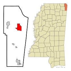
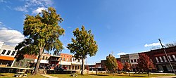
Iuka is a city in and the county seat of Tishomingo County, [2] Mississippi, United States. Its population was 3,028 at the 2010 census. Woodall Mountain, the highest point in Mississippi, is located just south of Iuka.
Iuka is built on the site of a Chickasaw village that is thought to have been subordinate to the settlement at Underwood Village. The name "Iuka" comes from the name of one of the chiefs of the village. Iuka was founded by David Hubbard, a wagon train scout.
Euro-American settlers arrived with the Memphis and Charleston Railroad in 1857. Before the American Civil War, the town boasted an all-female college, a boys' military academy, and a fine hotel. The Civil War brought widespread devastation when a major engagement here occurred on September 19, 1862. The Battle of Iuka resulted in 1200 to 1500 killed or wounded. The dead Confederate soldiers were buried in a long trench that eventually became Shady Grove Cemetery.
The first normal school built in the former Confederacy after the Civil War, Iuka Normal Institute, was built here. However, the town did not return to prosperity for many years. The building of Pickwick Landing Dam and Pickwick Lake by the Tennessee Valley Authority brought activity back to the town.
In 1904, water from Iuka's mineral springs won first prize for the purest and best mineral water at the World's Fair in St. Louis.
Iuka is located in northeast Mississippi. U.S. Route 72 runs through the southern part of the city from west to east, leading southeast 14 mi (23 km) to Cherokee, Alabama, and northwest 8 mi (13 km) to Burnsville. Mississippi Highway 25 runs to the west of downtown from south to north, leading north 16 mi (26 km) to Red Sulphur Springs, Tennessee, and south 13 mi (21 km) to Tishomingo.
According to the United States Census Bureau, the city has a total area of 9.7 square miles (25 km2), all land.
Climate is characterized by relatively high temperatures and evenly distributed precipitation throughout the year. The Köppen Climate Classification subtype for this climate is "Cfa" (humid subtropical climate). [3]
Climate data for Iuka, Mississippi | |||||||||||||
---|---|---|---|---|---|---|---|---|---|---|---|---|---|
Month | Jan | Feb | Mar | Apr | May | Jun | Jul | Aug | Sep | Oct | Nov | Dec | Year |
Mean daily maximum °F (°C) | 49 (9) | 54 (12) | 62 (17) | 72 (22) | 79 (26) | 86 (30) | 89 (32) | 90 (32) | 84 (29) | 73 (23) | 63 (17) | 52 (11) | 71 (22) |
Mean daily minimum °F (°C) | 27 (−3) | 29 (−2) | 37 (3) | 44 (7) | 54 (12) | 62 (17) | 66 (19) | 65 (18) | 57 (14) | 44 (7) | 37 (3) | 29 (−2) | 46 (8) |
Average precipitation inches (mm) | 5.3 (130) | 5.1 (130) | 5.9 (150) | 5 (130) | 5.9 (150) | 4.2 (110) | 4.2 (110) | 4 (100) | 4.2 (110) | 3.6 (91) | 5.5 (140) | 6.8 (170) | 59.7 (1,520) |
Source: Weatherbase [4] |
Census | Pop. | Note | %± |
---|---|---|---|
1880 | 845 | — | |
1890 | 1,019 | 20.6% | |
1900 | 882 | −13.4% | |
1910 | 1,221 | 38.4% | |
1920 | 1,306 | 7.0% | |
1930 | 1,441 | 10.3% | |
1940 | 1,664 | 15.5% | |
1950 | 1,527 | −8.2% | |
1960 | 2,010 | 31.6% | |
1970 | 2,389 | 18.9% | |
1980 | 2,846 | 19.1% | |
1990 | 3,122 | 9.7% | |
2000 | 3,059 | −2.0% | |
2010 | 3,028 | −1.0% | |
2020 | 3,139 | 3.7% | |
U.S. Decennial Census [5] |
Race | Num. | Perc. |
---|---|---|
White (non-Hispanic) | 2,734 | 87.1% |
Black or African American (non-Hispanic) | 188 | 5.99% |
Native American | 13 | 0.41% |
Asian | 8 | 0.25% |
Other/Mixed | 130 | 4.14% |
Hispanic or Latino | 66 | 2.1% |
As of the 2020 United States census, there were 3,139 people, 1,244 households, and 727 families residing in the city.
As of the census [7] of 2000, there were 3,059 people, 1,325 households, and 809 families residing in the city. The population density was 316.6 people per square mile (122.2 people/km2). There were 1,550 housing units at an average density of 160.4 per square mile (61.9/km2). The racial makeup of the city was 91.14% White, 7.09% African American, 0.23% Native American, 0.16% Asian, 0.59% from other races, and 0.78% from two or more races. Hispanic or Latino of any race were 1.21% of the population.
There were 1,325 households, out of which 25.0% had children under the age of 18 living with them, 44.8% were married couples living together, 13.4% had a female householder with no husband present, and 38.9% were non-families. 36.9% of all households were made up of individuals, and 17.4% had someone living alone who was 65 years of age or older. The average household size was 2.13 and the average family size was 2.77.
In the city, the population was spread out, with 19.5% under the age of 18, 7.4% from 18 to 24, 23.4% from 25 to 44, 23.7% from 45 to 64, and 26.1% who were 65 years of age or older. The median age was 45 years. For every 100 females, there were 76.9 males. For every 100 females age 18 and over, there were 72.1 males.
The median income for a household in the city was $24,082, and the median income for a family was $36,863. Males had a median income of $30,449 versus $20,658 for females. The per capita income for the city was $17,261. About 16.0% of families and 20.4% of the population were below the poverty line, including 26.6% of those under age 18 and 15.4% of those age 65 or over.
A major employer in Iuka's industrial sector is Alliant Techsystems, a major U.S. aerospace and defense contractor.
Iuka is home to the Apron Museum, the only museum in the United States dedicated to aprons.
The Secret Sisters, a singing and songwriting duo from neighboring Colbert County, Alabama, wrote a song called "Iuka" for their album Put Your Needle Down . Greg Puckett, a country singer/songwriter from Iuka, MS, wrote a song called "Sittin in Iuka" for his album A Certain Man.Blues guitarist Albert King recorded the Don Nix-penned "Going Back to Iuka."
Tishomingo County is a county located in the northeastern corner of the U.S. state of Mississippi. As of the 2020 census, the population was 18,850. Its county seat is Iuka.
Calera is a city in Shelby and Chilton counties in the U.S. state of Alabama. It is the location of the Shelby County Airport.
Red Bay is a city in Franklin County, Alabama, United States. It was founded in 1907; its western boundary line is integral with the state line between Mississippi and Alabama. The population was 3,232 at the 2020 census. The town's name comes from the area's red clay soil and the many redbay trees in this area of north Alabama.
Waterloo is a town in Lauderdale County, Alabama, United States. It is part of the Florence–Muscle Shoals metropolitan area, known as "The Shoals". As of the 2010 census, the population of the town was 203, down from 208 in 2000. The town and surrounding area is served by Waterloo High School and by the Waterloo Volunteer Fire Department.
College City is a former town in Lawrence County, Arkansas, United States. The population was 455 at the 2010 census. It is the site of Williams Baptist College, a four-year liberal arts college. The town merged with nearby Walnut Ridge effective January 1, 2017.
Manila is a city in Mississippi County, Arkansas, United States. The population was 3,682 at the 2020 census, up from 3,342 in 2010. It was the hometown of World War I sniper Herman Davis.
Fairdale is a former census-designated place in southern Jefferson County, Kentucky, United States. The population was 7,658 at the 2000 census. In 2003, the area was annexed to the city of Louisville due to a merger between the city and Jefferson County's unincorporated community. Fairdale is now a neighborhood within the city limits of Louisville. The ZIP Code for Fairdale is 40118.
Springfield is a home rule-class city in and the county seat of Washington County, Kentucky, United States. The population was 2,846 at the 2020 census.
Hernando is the county seat of DeSoto County, on the northwestern border of Mississippi, United States. The population was 17,138 according to the 2020 census records. It is located on the south side of the Memphis, Tennessee metro area. U.S. Route 51 and the I-55 freeway traverse the city from north to south, and the I-69 freeway crosses the city from east to west. The county courthouse is located within Hernando's historic downtown square. It is located at the intersection of Commerce Street and present-day U.S. 51.
Booneville is a city in the U.S. state of Mississippi and is the county seat of Prentiss County. It is located in the hilly North Mississippi region, and ecologically is part of the Southeastern Plains region.
Belmont is a town in Tishomingo County, Mississippi, United States. The population was 2,021 at the 2010 census.
Burnsville is a town in Tishomingo County in northeastern Mississippi, United States. The population was 936 at the 2010 census.
Tishomingo is a town in Tishomingo County, Mississippi, United States. The population of the city of Tishomingo was 339 at the 2010 census.
Schurz is an unincorporated community and census-designated place (CDP) in Mineral County, Nevada, United States. The population was 656 at the 2020 census. It is located on the Walker River Indian Reservation and is the burial place of Wovoka, the Paiute messiah who originated the Ghost Dance movement.
Kosciusko is a city in Attala County, Mississippi, United States. The population was 7,402 at the 2010 census. It is the county seat of Attala County.
Tishomingo is the largest city in, and the county seat of, Johnston County, Oklahoma, United States. The population was 3,101 as of the 2020 Census, an increase of 2.2% over the population of 3,034 reported at the 2010 census. It was the first capital of the Chickasaw Nation, from 1856 until Oklahoma statehood in 1907. The city is home to Murray State College, a community college with an annual enrollment of 3,015 students. Tishomingo is part of the Texoma region.
Celina is a city in and the county seat of Clay County, Tennessee, United States. The population was 1,495 at the 2010 census.
Loudon is a city in and the county seat of Loudon County, Tennessee, United States. Its population was 6,001 at the 2020 census. It is included in the Knoxville, Tennessee Metropolitan Statistical Area. The city is located in East Tennessee, southwest of Knoxville, on the Tennessee River. Fort Loudoun, the colonial era fort for which the city was named, is located several miles to the south in Monroe County.
Baldwyn is a city in Lee and Prentiss counties, Mississippi, United States. It is located in the northern part of the Tupelo micropolitan area. Founded in 1860, the population was 3,071 at the 2020 census.
Humboldt is a city in Gibson and Madison counties, Tennessee. The population was 8,452 at the 2010 census, a decline of 1,015 from 2000. It is the principal city of and is included in the Humboldt, Tennessee Micropolitan Statistical Area, which is included in the Jackson-Henderson-Humboldt, Tennessee Metropolitan Area.