Leisureville, Florida

Last updated
Leisureville, Florida
Coordinates: 26°15′53″N80°7′29″W / 26.26472°N 80.12472°W / 26.26472; -80.12472 Coordinates: 26°15′53″N80°7′29″W / 26.26472°N 80.12472°W / 26.26472; -80.12472
Country Flag of the United States.svg  United States
State Flag of Florida.svg  Florida
County   Broward
Area
  Total0.2 sq mi (0.6 km2)
  Land0.2 sq mi (0.6 km2)
  Water0.0 sq mi (0.0 km2)
Population
 (2000)
  Total1,147
  Density5,255.3/sq mi (2,029.1/km2)
Time zone UTC-5 (Eastern (EST))
  Summer (DST) UTC-4 (EDT)
FIPS code 12-39957 [1]

Leisureville was a census-designated place (CDP) in Broward County, Florida, United States, and now a neighborhood of the City of Pompano Beach, Florida. The population was 1,147 at the 2000 census.

Contents

Geography

Leisureville is located at 26°15′53″N80°7′29″W / 26.26472°N 80.12472°W / 26.26472; -80.12472 (26.264808, -80.124840). [2]

According to the United States Census Bureau, the CDP has a total area of 0.6 km2 (0.2 mi2), all land.

Demographics

As of the census [1] of 2000, there were 1,147 people, 725 households, and 300 families residing in the CDP. The population density was 2,013.0/km2 (5,255.3/mi2). There were 917 housing units at an average density of 1,609.3/km2 (4,201.5/mi2). The racial makeup of the CDP was 83.96% White (80.1% were Non-Hispanic White,) [3] 10.72% African American, 0.35% Native American, 0.61% Asian, 0.09% Pacific Islander, 0.26% from other races, and 4.01% from two or more races. Hispanic or Latino of any race were 4.62% of the population.

There were 725 households, out of which 3.7% had children under the age of 18 living with them, 35.0% were married couples living together, 5.1% had a female householder with no husband present, and 58.5% were non-families. 54.2% of all households were made up of individuals, and 45.2% had someone living alone who was 65 years of age or older. The average household size was 1.58 and the average family size was 2.25.

In the CDP, the population was spread out, with 5.2% under the age of 18, 2.4% from 18 to 24, 8.3% from 25 to 44, 16.1% from 45 to 64, and 68.0% who were 65 years of age or older. The median age was 72 years. For every 100 females, there were 72.5 males. For every 100 females age 18 and over, there were 72.5 males.

The median income for a household in the CDP was $25,463, and the median income for a family was $30,700. Males had a median income of $25,179 versus $15,865 for females. The per capita income for the CDP was $21,334. About 7.9% of families and 6.1% of the population were below the poverty line, including 50.0% of those under age 18 and 2.9% of those age 65 or over.

As of 2000, English as a first language accounted for 86.24% of all residents, while French Creole was accounted for 10.05%, and German as a mother tongue made up 3.70% of the population. [4]

Related Research Articles

Hidden Meadows, California Census designated place in California, United States

Hidden Meadows is a census-designated place (CDP) near Escondido in San Diego County, California. The population was 3,485 at the 2010 census, up from 3,463 at the 2000 census.

Boulevard Gardens is a census-designated place (CDP) in Broward County, Florida, United States. The population was 1,274 at the 2010 census.

Green Meadow was a census-designated place (CDP) in Broward County, Florida, United States. The population was 1,875 at the 2000 census. It was incorporated into the town of Southwest Ranches, Florida in 2000.

Riverland Village is a former census-designated place in Broward County, Florida, United States. It was annexed to the city of Fort Lauderdale in 2002 and is currently classed as a neighborhood of the city. The population was 2,108 at the 2000 census.

Bellview, Florida Census-designated place in Florida, United States

Bellview is a census-designated place (CDP) in Escambia County, Florida, United States. The population was 23,355 at the 2010 census. It is part of the Pensacola–Ferry Pass–Brent Metropolitan Statistical Area.

Fremd Village-Padgett Island was a census-designated place (CDP) in Palm Beach County, Florida, United States. The population was 2,264 at the 2000 census.

Lake Belvedere Estates is a census-designated place (CDP) in Palm Beach County, Florida, United States. The population was 1,525 at the 2000 census.

Mission Bay, Florida unincorporated place in Florida, United States

Mission Bay is a census-designated place (CDP) located in an unincorporated area near Boca Raton in Palm Beach County, Florida, United States. The population was 2,926 at the 2000 census. While it is not officially in the City of Boca Raton, the community is frequently classified under its umbrella term.

St. Dennis, Louisville Census-designated place in Kentucky, United States

St. Dennis is a former census-designated place in western Jefferson County, Kentucky, United States. The population was 9,177 at the 2000 census. In 2003, the area was consolidated into the new Louisville Metro due to the merger of the Jefferson County and Louisville governments into one entity, thus St. Dennis remains as a unique neighborhood within Louisville.

Salem, Kentucky City in Kentucky, United States

Salem is a home rule-class city in Livingston County, Kentucky, in the United States. Salem is part of the Paducah micropolitan area. The population was 752 during the 2010 census, down from 769 in 2000. It the largest city in Livingston County, although the unincorporated community of Ledbetter has more than twice the population of Salem.

Baldwinville, Massachusetts CDP in Massachusetts, United States

Baldwinville is an unincorporated village and census-designated place (CDP) in the town of Templeton in Worcester County, Massachusetts, United States. The population was 2,028 at the 2010 census. The name also refers to the local post office or railroad station. Some people, perhaps confusing it with the village in New York state, erroneously call it "Baldwinsville".

Silver Ridge, New Jersey Census-designated place in New Jersey, United States

Silver Ridge is an unincorporated community and census-designated place (CDP) located within Berkeley Township, in Ocean County, New Jersey, United States. As of the 2010 United States Census, the CDP's population was 1,133.

East Hampton North, New York Census-designated place in New York, United States

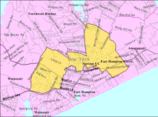
East Hampton North is a census-designated place (CDP) in Suffolk County, New York, United States. At the 2010 census, the population was 4,142.

Westhampton, New York Hamlet and census-designated place in New York, United States

Westhampton is a hamlet and census-designated place (CDP) in Suffolk County, New York, United States. The population was 3,079 at the 2010 census.

Ross, Ohio Census-designated place in Ohio, United States

Ross is a census-designated place (CDP) in Ross Township, Butler County, Ohio, United States. The population was 3,417 at the 2010 census, up from 1,971 in 2000.

Meadowood, Pennsylvania Census-designated place in Pennsylvania, United States

Meadowood is a census-designated place (CDP) in Butler County, Pennsylvania, United States. The population was 2,693 at the 2010 census.

Elgin, Lancaster County, South Carolina CDP in South Carolina, United States

Elgin is a census-designated place (CDP) in Lancaster County, South Carolina, United States. The population was 2,426 at the 2000 census.

Moses Lake North, Washington Census-designated place in Washington, United States

Moses Lake North is a census-designated place (CDP) in Grant County, Washington, United States. The population was 4,418 at the 2010 census, up from 4,232 at the 2000 census.

Daniels, West Virginia Census-designated place in West Virginia, United States

Daniels is a census-designated place (CDP) in Raleigh County, West Virginia, United States. The population was 1,881 at the 2010 census.

Hingham (CDP), Massachusetts Census-designated place in Massachusetts, United States

Hingham is a census-designated place (CDP) in the town of Hingham in Plymouth County, Massachusetts, United States. The population was 5,650 at the 2010 census.

References

  1. 1 2 "U.S. Census website". United States Census Bureau . Retrieved 2008-01-31.
  2. "US Gazetteer files: 2010, 2000, and 1990". United States Census Bureau. 2011-02-12. Retrieved 2011-04-23.
  3. "Demographics of Leisureville, FL". MuniNetGuide.com. Archived from the original on 2008-04-28. Retrieved 2007-11-16.
  4. "MLA Data Center Results for Leisureville, FL". Modern Language Association . Retrieved 2007-11-16.