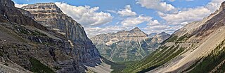
Kootenay National Park is a national park of Canada in southeastern British Columbia. The park consists of 1,406 km2 (543 sq mi) of the Canadian Rockies, including parts of the Kootenay and Park mountain ranges, the Kootenay River and the entirety of the Vermilion River. While the Vermilion River is completely contained within the park, the Kootenay River has its headwaters just outside the park boundary, flowing through the park into the Rocky Mountain Trench and eventually joining the Columbia River. The park ranges in elevation from 918 m (3,012 ft) at the southwestern park entrance to 3,424 m (11,234 ft) at Deltaform Mountain.

The Monarch is a 2,895-metre (9,498-foot) mountain summit located in the Ball Range of the Canadian Rockies in British Columbia, Canada. The Monarch is situated on the boundary between Kootenay National Park and Mount Assiniboine Provincial Park, four kilometres to the west side of the Continental Divide. Although not visible from roads, The Monarch is a prominent feature seen from the slopes above Sunshine Village ski resort. Its nearest higher peak is Mount Bourgeau, 10.35 km (6.43 mi) to the north-northeast.

Hewitt Peak is a 3,066-metre (10,059 ft) mountain summit located on the western border of Kootenay National Park, in the Canadian Rockies of British Columbia, Canada. The peak is also known locally as Mammoth Peak, and originally as Mount 10060. The alternate names derive from its outline profile resembling a mammoth, and its elevation as measured in feet. No name for this mountain has been officially adopted yet. Its nearest higher peak is Tumbling Peak, 2.5 km (1.6 mi) to the north-northwest, and both are part of the Vermilion Range. Park visitors can catch a glimpse of the peak from Highway 93, also known as the Banff–Windermere Highway.

Wedgwood Peak is a 3,024-metre (9,921-foot) mountain summit located in Mount Assiniboine Provincial Park, in the Canadian Rockies of British Columbia, Canada. Its nearest higher peak is Mount Assiniboine, 2.0 km (1.2 mi) to the south. The mountain is situated northwest of Lake Magog and 1.0 km (0.62 mi) south of Sunburst Peaks.

The Marshall is a 3,180-metre (10,430-foot) mountain summit located in Mount Assiniboine Provincial Park, in the Canadian Rockies of British Columbia, Canada. Its nearest higher peak is Mount Assiniboine, 3.0 km (1.9 mi) to the east-southeast. The mountain is situated west of Wedgwood Peak.

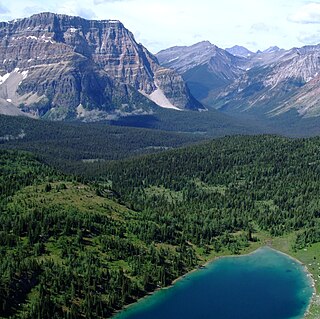
Scarab Peak is a 2,918-metre (9,573 ft) mountain summit located on the Continental Divide, on the shared border between Banff and Kootenay national parks in Canada. Scarab Peak is part of the Ball Range in the Canadian Rockies. The peak is situated one kilometre east-southeast of Haiduk Peak and 8.32 km (5.17 mi) southeast of Mount Ball. The mountain's name scarab was in keeping with the Egyptian theme of the immediate area, e.g., Egypt Lake, Mummy Lake, Pharaoh Peaks, names which were applied in 1922 by Arthur O. Wheeler of the Interprovincial Boundary Survey. Wheeler regarded the area particularly beautiful when he wrote: "After 30 years of exploration, surveys and mapping the main ranges of the Canadian Rockies, the writer ... can safely say that outstanding among them for scenic charm and interest may be classed the group of peaks, lakes and alpine meadows of the Egypt Lake area."
Mount Watson is a 2,955-metre (9,695-foot) mountain summit located in Mount Assiniboine Provincial Park, in the Canadian Rockies of British Columbia, Canada. The nearest higher peak is The Marshall, 2.0 km (1.2 mi) to the southeast.

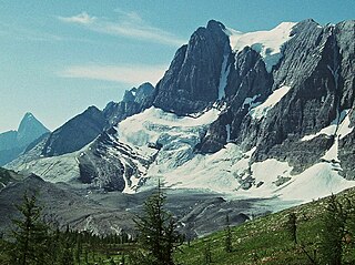
Floe Peak is a 3,006-metre (9,862 ft) mountain summit located on the western border of Kootenay National Park, in the Canadian Rockies of British Columbia, Canada. The name for this mountain has not been officially adopted yet. Its nearest higher peak is Foster Peak, 3.0 km (1.9 mi) to the northwest, and both are part of the Vermilion Range. The mountain is part of what is known as the Rockwall in the Vermilion Range, and is named for Floe Lake which is situated below the enormous northern cliffs of the peak. Floe Lake, one of the beauty spots of Kootenay Park, is accessible via the Floe Lake Trail.

Foster Peak is a 3,204-metre (10,512-foot) mountain summit located on the western border of Kootenay National Park. It is the highest point in the Vermilion Range, a sub-range of the Canadian Rockies of British Columbia, Canada. Its nearest higher peak is Mount Ball, 14.96 km (9.30 mi) to the northeast. The mountain is part of what is known as The Rockwall. Floe Lake, southeast of the peak, is one of the beauty spots of Kootenay National Park. The area is accessible via the Floe Lake Trail and Rockwall Trail. The Rockwall Trail is a scenic 55 kilometre traverse of alpine passes, subalpine meadows, hanging glaciers, and limestone cliffs, in some places in excess of 900 metres above the trail.

Mount Drysdale is a 2,932-metre (9,619-foot) mountain summit located on the western border of Kootenay National Park in the Vermilion Range, which is a sub-range of the Canadian Rockies of British Columbia, Canada. Its nearest higher peak is Rockwall Peak, 1.0 km (0.62 mi) to the west. The mountain is part of what is known as the Rockwall which is an escarpment of the Vermilion Range. The Rockwall Trail is a scenic 55 kilometre traverse of alpine passes, subalpine meadows, hanging glaciers, and limestone cliffs, in some places in excess of 900 m (2,950 ft) above the trail.

Mount Gray is a 2,886-metre (9,469-foot) mountain summit located on the western border of Kootenay National Park in the Vermilion Range, which is a sub-range of the Canadian Rockies in British Columbia, Canada. Its nearest higher peak is Tumbling Peak, 3.1 km (1.9 mi) to the southeast. The mountain is part of what is known as the Rockwall which is an escarpment of the Vermilion Range. The Rockwall Trail is a scenic 55 kilometre traverse of alpine passes, subalpine meadows, hanging glaciers, and limestone cliffs, in some places in excess of 900 m (2,953 ft) above the trail.
Tumbling Peak is a 3,145-metre (10,318-foot) mountain summit located on the western border of Kootenay National Park in the Vermilion Range, which is a sub-range of the Canadian Rockies of British Columbia, Canada. The mountain takes its name from the Tumbling Glacier located on its northeast flank. Its nearest higher peak is Foster Peak, 6.8 km (4.2 mi) to the southeast. Hewitt Peak is also to the southeast, and Mount Gray is to the immediate northwest. The mountain is situated in an area known as the Rockwall, which is an escarpment of the Vermilion Range. The Rockwall Trail is a scenic 55 kilometers traverse of alpine passes, sub-alpine meadows, hanging glaciers, and limestone cliffs, in some places in excess of 900 meters above the trail.

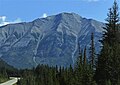
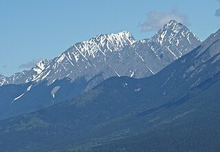
Mount Harkin is a 2,979-metre (9,774-foot) mountain summit located in the Kootenay River Valley along the eastern border of Kootenay National Park. Park visitors can see the peak from Highway 93, also known as the Banff–Windermere Highway. It is part of the Mitchell Range, which is a sub-range of the Canadian Rockies of British Columbia, Canada. Its nearest higher peak is Mount Assiniboine, 14.0 km (8.7 mi) to the northeast.
Mount Selkirk is a 2,930-metre (9,610-foot) mountain summit located in the Vermilion River Valley along the eastern border of Kootenay National Park. Park visitors can see the peak from Highway 93, also known as the Banff–Windermere Highway. It is part of the Mitchell Range, which is a sub-range of the Canadian Rockies of British Columbia, Canada. The nearest higher neighbor is Catlin Peak, 1.6 km (0.99 mi) to the northwest.

Vermilion Peak is a 2,647-metre (8,684-foot) mountain summit located in the Vermilion River Valley of Kootenay National Park, in British Columbia, Canada. It is part of the Ball Range, which is a sub-range of the Canadian Rockies. Its nearest higher peak is Stanley Peak, 2.8 km (1.7 mi) to the east. Vermilion Peak can be seen from the Banff–Windermere Parkway as it traverses the base of the mountain.

Limestone Peak is a 2,878-metre (9,442-foot) mountain summit located in British Columbia, Canada.

Nestor Peak is a 2,972-metre (9,751-foot) mountain summit located in Mount Assiniboine Provincial Park of British Columbia, Canada.

Indian Peak is a 2,992-metre (9,816-foot) mountain summit located in Mount Assiniboine Provincial Park of British Columbia, Canada.

Octopus Mountain is a 2,932-metre (9,619-foot) mountain summit located in Mount Assiniboine Provincial Park of British Columbia, Canada.

Mount Sam is a 2,871-metre (9,419-foot) mountain summit located in Mount Assiniboine Provincial Park of British Columbia, Canada.