Mount Engadine is a 2,972-metre (9,751-foot) mountain summit located in the Spray River Valley of Kananaskis Country, in the Canadian Rockies of Alberta, Canada. It was named in 1917 after HMS Engadine, a seaplane tender of the Royal Navy present at the Battle of Jutland during World War I. The mountain is located in the Kananaskis Range in Alberta.

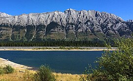
Mount Black Prince is a 2,939-metre (9,642-foot) mountain summit located in Peter Lougheed Provincial Park in the Canadian Rockies of Alberta, Canada. Its nearest higher peak is Mount Smith Dorrien, 5.8 km (3.6 mi) to the northwest. The mountain can be seen from Highway 742, also known as Smith-Dorrien/Spray Trail.

Mount Blane is a 2,993-metre (9,820-foot) mountain summit located in the Opal Range of the Canadian Rockies of Alberta, Canada. Its nearest higher peak is Mount Jerram, 3.3 km (2.1 mi) to the southeast.
Mount Brock is a 2,902-metre (9,521-foot) mountain summit located in the Opal Range of the Canadian Rockies of Alberta, Canada. Its nearest higher peak is Mount Evan-Thomas, 3.3 km (2.1 mi) to the north.

Elpoca Mountain is a 3,036-metre (9,961-foot) mountain summit located at the southern end of the Opal Range in the Canadian Rockies of Alberta, Canada. The nearest higher peak is Mount Evan-Thomas, 12.0 km (7.5 mi) to the north. Elpoca Mountain is situated 4.0 kilometres south of Mount Jerram, and 2.0 km east of Gap Mountain, and all are within Peter Lougheed Provincial Park. Precipitation runoff from the west side of the mountain drains into tributaries of the Kananaskis River, whereas the east side drains into Elbow River.

Mount Invincible is a 2,700-metre (8,900-foot) mountain summit located in Peter Lougheed Provincial Park in the Canadian Rockies of Alberta, Canada. The peak is visible from Alberta Highway 40, and the Upper and Lower Kananaskis Lakes area. Mount Invincible's nearest higher peak is Mount Warspite, 2.6 km (1.6 mi) to the northwest.

Mount Sparrowhawk is a 3,121-metre (10,240 ft) mountain summit located in Kananaskis Country in the Canadian Rockies of Alberta, Canada. Mount Sparrowhawk's nearest higher peak is Mount Bogart, 3.6 km (2.2 mi) to the southeast. Sparrowhawk's south slope was a candidate to be used as a ski hill for the alpine events at the 1988 Winter Olympics, but nearby Mount Allan's Nakiska was selected instead.

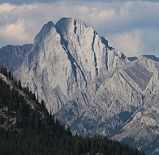
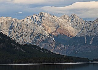
Mount Evan-Thomas is a 3,097-metre (10,161-foot) mountain summit located in the Opal Range of the Canadian Rockies of Alberta, Canada. Mount Evan-Thomas is the highest point in the Opal Range. It is situated in the Kananaskis River Valley northeast of Lower Kananaskis Lake and east of Highway 40 in Peter Lougheed Provincial Park. Its nearest higher peak is Mount Rae, 18.0 km (11.2 mi) to the south-southeast.

Mount Lyautey is a 3,045-metre (9,990-foot) mountain summit located in Kananaskis Country in the Canadian Rockies of Alberta, Canada. Mount Lyautey is situated 2.0 kilometres east of the Continental Divide, within Peter Lougheed Provincial Park. Its nearest higher peak is Mount Joffre, 8.0 km (5.0 mi) to the south. Mount Lyautey can be seen from Upper Kananaskis Lake and Alberta Highway 40.
Mount Jerram is a 2,996-metre (9,829-foot) mountain summit located in the Opal Range of the Canadian Rockies of Alberta, Canada. Its nearest higher peak is Elpoca Mountain, 4.0 km (2.5 mi) to the south-southeast. Mount Jerram is situated east of Mount Wintour, within Peter Lougheed Provincial Park.

Gap Mountain is a 2,675-metre (8,776-foot) mountain summit located at the southern end of the Opal Range in the Canadian Rockies of Alberta, Canada. The nearest higher neighbor is Elpoca Mountain, 2 km (1.2 mi) to the east. Gap Mountain is situated 5 km (3.1 mi) south of Mount Wintour, within Peter Lougheed Provincial Park. Gap Mountain is a conspicuous peak seen from Alberta Highway 40 at Highwood Pass. It is a popular climbing destination because it offers exposed scrambling on its eastern flanks with excellent summit views of Kananaskis Country.

Mount Indefatigable is a 2,667-metre (8,750-foot) mountain summit located in Peter Lougheed Provincial Park in the Canadian Rockies of Alberta, Canada. The peak is visible from Alberta Highway 40, and the Kananaskis Lakes area. Mount Indefatigable's nearest higher neighbour is Mount Invincible, 1.8 km (1.1 mi) to the northwest.

Mount Sarrail is a 3,159-metre (10,364-foot) mountain summit located in Kananaskis Country in the Canadian Rockies of Alberta, Canada. Mount Sarrail is situated 1.0 kilometre north of the Continental Divide, within Peter Lougheed Provincial Park. Its nearest higher peak is Mount Foch, 1.0 km (0.62 mi) to the southeast. Mount Sarrail can be seen from Upper Kananaskis Lake and Alberta Highway 40.

Mount Shark is a 2,786-metre (9,140-foot) mountain summit located in the Spray Valley of Kananaskis Country at the northern tip of the Spray Mountains range. It is situated on the southern boundary of Banff National Park in the Canadian Rockies of Alberta, Canada. Mount Shark in not visible from any road in Banff Park, however, it can be seen from Alberta Highway 742, also known as the Smith-Dorrien/Spray Trail. Mount Shark's nearest higher peak is Mount Smuts, 3.0 km (1.9 mi) to the southeast.

Mount Packenham is a 3,000-metre (9,800-foot) mountain summit located in the Opal Range of the Canadian Rockies of Alberta, Canada. Its nearest higher peak is Mount Evan-Thomas, 1.0 km (0.62 mi) to the north. Situated on the eastern boundary of Peter Lougheed Provincial Park, the peak is visible from Highway 40 and the Kananaskis Lakes area.

Marvel Peak is a 2,708-metre (8,885-foot) mountain summit located in the southern tip of Banff National Park, in the Canadian Rockies of Alberta, Canada. Marvel Peak is situated in the Blue Range, three kilometers from the Continental Divide, and not visible from any road. Marvel Peak's nearest higher peak is Wonder Peak, 3.29 km (2.04 mi) to the north-northwest.

Mount Jellicoe is a 3,075-metre (10,089-foot) mountain summit located in Peter Lougheed Provincial Park in the Canadian Rockies of Alberta, Canada. Its nearest higher peak is Mount Smith-Dorrien, 2.0 km (1.2 mi) to the north. The Haig Glacier lies below the west aspect of Jellicoe, and the Smith-Dorrien Glacier lies to the north. The Continental Divide is 2.0 km (1.2 mi) to the west.

Fisher Peak is a 3,053-metre (10,016-foot) mountain summit located in the Fisher Range of Kananaskis Country in the Canadian Rockies of Alberta, Canada. Fisher Peak is the highest point in the Fisher Range, so its nearest higher peak is Mount Evan-Thomas, 7.0 km (4.3 mi) to the southwest in the Opal Range. Precipitation runoff from the mountain drains west into Evan-Thomas Creek, which is a tributary of the Kananaskis River, or east into the Little Elbow River which is a tributary of the Elbow River.

Mount Warspite is a 2,860-metre (9,380-foot) mountain summit located in Peter Lougheed Provincial Park in the Canadian Rockies of Alberta, Canada. The peak is visible from Smith-Dorrien Road (742), and Alberta Highway 40 in the Kananaskis Lakes area. Mount Warspite's nearest higher peak is Mount Black Prince, located 2.4 km (1.5 mi) to the northwest.

Tombstone Mountain is a 3,002-metre (9,849-foot) double summit mountain located near the southern end of the Opal Range in Kananaskis Country of the Canadian Rockies in Alberta, Canada. Tombstone South is the lower of the two summits, and is labelled as Tombstone Mountain on some maps. It can be reached via scrambling, whereas the true north summit requires technical climbing. Tombstone Mountain is situated within Elbow-Sheep Wildland Provincial Park, and its nearest higher peak is Elpoca Mountain, 4.0 km (2.5 mi) to the south.