Nathan, Queensland

Last updated

Map all coordinates using: OpenStreetMap  
Nathan
Brisbane,  Queensland
QSAC2009-01.jpg
Australia Queensland location map.svg
Red pog.svg
Nathan
Coordinates 27°33′03″S153°03′12″E / 27.5508°S 153.0533°E / -27.5508; 153.0533 (Nathan (centre of suburb))
Population1,085 (2021 census) [1]
 • Density212.7/km2 (551/sq mi)
Established1967
Postcode(s) 4111
Area5.1 km2 (2.0 sq mi)
Time zone AEST (UTC+10:00)
LGA(s) City of Brisbane
(Moorooka Ward) [2]
State electorate(s) Toohey
Federal division(s) Moreton
Suburbs around Nathan:
Tarragindi Holland Park West Mount Gravatt
Salisbury Nathan Upper Mount Gravatt
Coopers Plains Robertson MacGregor

Nathan is a suburb in the City of Brisbane, Queensland, Australia. [3] In the 2021 census, it had a population of 1,085. [1]

Geography

Nathan is home to Toohey Forest Conservation Park, [4] Griffith University's Nathan campus and the Queensland Sport and Athletics Centre which hosted the opening ceremony of the 1982 Commonwealth Games. The Queensland Academy of Sport currently uses the facilities located at the stadium. The Mount Gravatt Cemetery is part of Nathan.[ citation needed ]

Nathan remains sparsely populated, with much of the park and university campus being filled with eucalypt forest, grass trees, banksia and leptospermum. Local fauna include tawny frogmouths, powerful owl, hoary wattled bats, sugar gliders, greater gliders, squirrel gliders, flying foxes and possums.[ citation needed ]

Surrounding suburbs include MacGregor, Robertson, Salisbury, Coopers Plains, Tarragindi, Holland Park and Upper Mount Gravatt.[ citation needed ]

The Mount Gravatt Cemetery and Crematorium is located in the suburb along Mains Road. [5]

History

The Mount Gravatt cemetery opened in 1918. [5]

The suburb was named on 1 August 1967 after Sir Matthew Nathan, Governor of Queensland from 1920 to 1926. [3] [6]

Demographics

In the 2011 census the population of Nathan was 1,397, 48.4% female and 51.6% male. [7] The median age of the Nathan population was 24 years of age, 13 years below the Australian median. Almost half of the population (41.4%) were aged in the range 15–24, compared to the national average of 13.3% in this range. [7] 65.3% of people living in Nathan were born in Australia, compared to the national average of 69.8%. The other top responses for country of birth were New Zealand 3.6%, China 3.4%, England 2.9%, India 2.2%, Germany 1.1%. [7] 75.6% of people spoke only English at home; the next most popular languages were 3.2% Mandarin, 1.5% Cantonese, 1.2% Vietnamese, 0.9% Indonesian, 0.8% Hindi. [7] The most popular religious affiliation was "no religion" (32%), followed by Catholic (21%) and Anglican (13%). [7] It is a culturally diverse suburb, with over 30% more overseas-born residents (27.57%) than the Brisbane average (21.03%). Although populated by local Aborigines until the 1940s, less than 1% of residents are indigenous Australians today. [7]

In the 2016 census, Nathan had a population of 1,183 people. [8]

Education

Toohey Forest Environmental Education Centre is an Outdoor and Environmental Education Centre at South Ring Road ( 27°33′10″S153°03′27″E / 27.5527°S 153.0574°E / -27.5527; 153.0574 (Toohey Forest Environmental Education Centre) ). [9] [10]

See also

Related Research Articles

<span class="mw-page-title-main">Griffith University</span> Public research university in Brisbane, Australia

Griffith University is a public research university in South East Queensland on the east coast of Australia. Founded in 1971, Griffith was opened in 1975, introducing Australia's first degrees in environmental science and Asian Studies. The university has five campuses in Gold Coast, Nathan, Logan, South Bank, and Mt Gravatt regions.The university was named after Sir Samuel Walker Griffith, who was twice Premier of Queensland and the first Chief Justice of the High Court of Australia. Sir Samuel Griffith played a major role in the Federation of Australia and was the principal author of the Australian constitution.

<span class="mw-page-title-main">Mansfield, Queensland</span> Suburb of Brisbane, Queensland, Australia

Mansfield is a suburb in the City of Brisbane, Queensland, Australia. In the 2016 census, Mansfield had a population of 8,695 people.

<span class="mw-page-title-main">Capalaba, Queensland</span> Suburb of Redland City, Queensland, Australia

Capalaba is an urban locality in the City of Redland, Queensland, Australia. In the 2016 census, Capalaba had a population of 17,333 people.

<span class="mw-page-title-main">Tingalpa, Queensland</span> Suburb of Brisbane, Queensland, Australia

Tingalpa is a suburb in the City of Brisbane, Queensland, Australia. In the 2016 census, Tingalpa had a population of 8,290 people.

<span class="mw-page-title-main">Mount Gravatt, Queensland</span> Suburb of Brisbane, Queensland, Australia

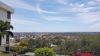
Mount Gravatt is a southern suburb of the City of Brisbane, Queensland, Australia and a prominent hill and lookout within this suburb. In the 2016 census, Mount Gravatt had a population of 3,366 people.

MacGregor is a southern suburb in the City of Brisbane, Queensland, Australia. At the 2017 census, MacGregor had a population of 6,302 people.

<span class="mw-page-title-main">Stretton, Queensland</span> Suburb of Brisbane, Queensland, Australia

Stretton is a southern suburb in the City of Brisbane, Queensland, Australia. In the 2016 census, Stretton had a population of 4,334. The suburb is known for its Hollywood-sized mansions on nearby streets off Gowan and Compton Roads.

<span class="mw-page-title-main">Holland Park, Queensland</span> Suburb of Brisbane, Queensland, Australia

Holland Park is a southern suburb in the City of Brisbane, Queensland, Australia. In the 2016 census, Holland Park had a population of 8,111 people.

<span class="mw-page-title-main">Carindale, Queensland</span> Suburb of Brisbane, Queensland, Australia

Carindale is a suburb of the City of Brisbane, Queensland, Australia. It is located 13.1 kilometres (8.1 mi) by road south-east of the Brisbane GPO, and borders Belmont, Carina, Carina Heights, Mackenzie, Mansfield, Mount Gravatt East, and Tingalpa. In the 2016 census, Carindale recorded a population of 15,740 people.

<span class="mw-page-title-main">Upper Mount Gravatt, Queensland</span> Suburb of Brisbane, Queensland, Australia

Upper Mount Gravatt is a southern suburb in the City of Brisbane, Queensland, Australia. In the 2016 census, Upper Mount Gravatt had a population of 9,241 people.

<span class="mw-page-title-main">Mackenzie, Queensland</span> Suburb of City of Brisbane, Queensland, Australia

Mackenzie is a south-eastern suburb in the City of Brisbane, Queensland, Australia. In the 2016 census, Mackenzie had a population of 2,094 people.

<span class="mw-page-title-main">Burbank, Queensland</span> Suburb of Brisbane, Queensland, Australia

Burbank is a greenbelt suburb in the City of Brisbane, Queensland, Australia. In the 2016 census, Burbank had a population of 1,050 people.

<span class="mw-page-title-main">Holland Park West, Queensland</span> Suburb of Brisbane, Queensland, Australia

Holland Park West is a suburb in the City of Brisbane, Queensland, Australia. In the 2016 census, Holland Park West had a population of 6,376 people.

<span class="mw-page-title-main">Bridgeman Downs, Queensland</span> Suburb of Brisbane, Queensland, Australia

Bridgeman Downs is a northern suburb in the City of Brisbane, Queensland, Australia. It is located 15.2 kilometres (9.4 mi) from the city centre and borders Moreton Bay Region to the west.

<span class="mw-page-title-main">Mount Gravatt East, Queensland</span> Suburb of Brisbane, Queensland, Australia

Mount Gravatt East is a southern suburb in the City of Brisbane, Queensland, Australia. In the 2016 census, Mount Gravatt East had a population of 11,838 people.

<span class="mw-page-title-main">Nudgee Beach, Queensland</span> Suburb of Brisbane, Queensland, Australia

Nudgee Beach is a suburb and beach in the City of Brisbane, Queensland, Australia. In the 2016 census, the suburb had a population of 263 people.

<span class="mw-page-title-main">Karawatha, Queensland</span> Suburb of Brisbane, Queensland, Australia

Karawatha is an outer southern suburb in the City of Brisbane, Queensland, Australia. In the 2016 census, Karawatha had a population of 19 people.

<span class="mw-page-title-main">Hemmant, Queensland</span> Suburb of Brisbane, Queensland, Australia

Hemmant is a suburb of the City of Brisbane, Queensland, Australia. In the 2016 census, Hemmant had a population of 2,385 people.

<span class="mw-page-title-main">Carina Heights, Queensland</span> Suburb of Brisbane, Queensland, Australia

Carina Heights is both a hill and a suburb in the City of Brisbane, Queensland, Australia. In the 2016 census, Carina Heights had a population of 6,732 people.

James Toohey (1827-1883) was a prominent Irish-Australian land owner of the early colony of Brisbane.

References

  1. 1 2 Australian Bureau of Statistics (28 June 2022). "Nathan". 2021 Census QuickStats. Retrieved 11 August 2022. OOjs UI icon edit-ltr-progressive.svg
  2. "Moorooka Ward". Brisbane City Council. Archived from the original on 12 March 2017. Retrieved 12 March 2017.
  3. 1 2 "Nathan – suburb in City of Brisbane (entry 44216)". Queensland Place Names. Queensland Government . Retrieved 6 March 2022.
  4. "Toohey Forest Park (Place ID 17672)". Australian Heritage Database . Australian Government. 14 May 1991. Retrieved 11 December 2018.
  5. 1 2 "Mount Gravatt Cemetery and Crematorium". Brisbane City Council. 4 October 2013. Archived from the original on 30 October 2013. Retrieved 20 October 2013.
  6. Roberts, Beryl (1991). Stories of the Southside. Archerfield, Queensland: Aussie Books. p. 9. ISBN   0-947336-01-X.
  7. 1 2 3 4 5 6 Australian Bureau of Statistics (31 October 2012). "Nathan (State Suburb)". 2011 Census QuickStats. Retrieved 11 February 2013. OOjs UI icon edit-ltr-progressive.svg
  8. Australian Bureau of Statistics (27 June 2017). "Nathan (SSC)". 2016 Census QuickStats. Retrieved 20 October 2018. OOjs UI icon edit-ltr-progressive.svg
  9. "State and non-state school details". Queensland Government. 9 July 2018. Archived from the original on 21 November 2018. Retrieved 21 November 2018.
  10. "Toohey Forest Environmental Education Centre". Archived from the original on 15 July 2018. Retrieved 21 November 2018.