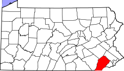
North Coventry Township | |
---|---|
Coordinates: 40°13′33″N75°39′52″W / 40.22583°N 75.66444°W | |
Country | United States |
State | Pennsylvania |
County | Chester |
Area | |
• Total | 13.51 sq mi (34.99 km2) |
• Land | 13.22 sq mi (34.25 km2) |
• Water | 0.29 sq mi (0.74 km2) |
Elevation | 299 ft (91 m) |
Population (2010) | |
• Total | 7,866 |
• Estimate (2016) [2] | 7,983 |
• Density | 603.68/sq mi (233.08/km2) |
Time zone | UTC-5 (EST) |
• Summer (DST) | UTC-4 (EDT) |
Area code(s) | 610 |
FIPS code | 42-029-54936 |
Website | www |
North Coventry Township is a township in Chester County, Pennsylvania, United States. The population was 7,866 at the 2010 census.
The township derives its name from Coventry, England, the native home of an early settler. [3]
The Pottstown Landing Historic District was listed on the National Register of Historic Places in 2001. [4]
According to the United States Census Bureau, the township has a total area of 13.6 square miles (35 km2), of which 13.4 square miles (35 km2) is land and 0.2 square miles (0.52 km2), or 1.18%, is water. It is drained by the Schuylkill River, which forms its natural northern boundary with Montgomery County. Its unincorporated communities include Cedarville, Cold Spring Park, Kenilworth, Pottstown Landing, Schenkel, South Pottstown, and Titlow Corner. The township is partially located in the Hopewell Big Woods.
The township has a hot-summer humid continental climate (Dfa) and average monthly temperatures in the vicinity of Coventry Mall range from 30.9 °F in January to 75.5 °F in July. The hardiness zone is 6b except near the river where it is 7a.
Census | Pop. | Note | %± |
---|---|---|---|
1930 | 2,837 | — | |
1940 | 3,030 | 6.8% | |
1950 | 3,242 | 7.0% | |
1960 | 4,367 | 34.7% | |
1970 | 6,690 | 53.2% | |
1980 | 7,164 | 7.1% | |
1990 | 7,506 | 4.8% | |
2000 | 7,381 | −1.7% | |
2010 | 7,866 | 6.6% | |
2020 | 8,441 | 7.3% | |
[5] [6] |
At the 2010 census, the township was 92.3% non-Hispanic White, 2.7% Black or African American, 0.2% Native American, 1.2% Asian, and 1.6% were two or more races. 2.3% of the population were of Hispanic or Latino ancestry. [7]
As of the census [8] of 2000, there were 7,381 people, 3,012 households, and 2,111 families residing in the township. The population density was 550.7 inhabitants per square mile (212.6/km2). There were 3,114 housing units at an average density of 232.4 per square mile (89.7/km2). The racial makeup of the township was 96.19% White, 1.79% African American, 0.20% Native American, 0.83% Asian, 0.28% from other races, and 0.70% from two or more races. Hispanic or Latino of any race were 0.91% of the population.
There were 3,012 households, out of which 28.9% had children under the age of 18 living with them, 58.9% were married couples living together, 8.2% had a female householder with no husband present, and 29.9% were non-families. 24.6% of all households were made up of individuals, and 8.0% had someone living alone who was 65 years of age or older. The average household size was 2.45 and the average family size was 2.95.
In the township the population was spread out, with 22.1% under the age of 18, 7.5% from 18 to 24, 28.8% from 25 to 44, 27.4% from 45 to 64, and 14.2% who were 65 years of age or older. The median age was 40 years. For every 100 females there were 98.4 males. For every 100 females age 18 and over, there were 97.0 males.
The median income for a household in the township was $51,954, and the median income for a family was $64,596. Males had a median income of $44,315 versus $30,635 for females. The per capita income for the township was $25,418. About 3.2% of families and 4.5% of the population were below the poverty line, including 5.4% of those under age 18 and 1.2% of those age 65 or over.
North Coventry Township is served by the Owen J. Roberts School District. [9] Owen J. Roberts High School is the zoned comprehensive high school.
As of 2019, there were 64.81 miles (104.30 km) of public roads in North Coventry Township, of which 21.16 miles (34.05 km) were maintained by the Pennsylvania Department of Transportation (PennDOT) and 43.65 miles (70.25 km) were maintained by the township. [10]
U.S. Route 422 is the most prominent highway serving North Coventry Township. It follows the Pottstown Expressway along an southeast-northwest alignment across the northeastern portion of the township. Pennsylvania Route 100 follows the Pottstown Pike along a north-south alignment across the eastern part of the township. Finally, Pennsylvania Route 724 follows Schuylkill Road along an east-west alignment across the northern portion of the township.
Notable people from North Coventry Township include Iowa State Senator J. Morris Rea, who was born there, as was Congressman Irving Price Wanger. Daryl Hall of Hall & Oates is from Cedarville in North Coventry.
Amity Township is a township in Berks County, Pennsylvania, United States. The population was 13,435 at the 2020 census. Amity Township, especially in the Douglassville area, is seeing growth in development.
Cumru Township is a township in Berks County, Pennsylvania, United States. The population was 15,638 at the 2020 census. Nolde Forest Environmental Education Center, a Pennsylvania state park, is in Cumru Township.
Douglass Township is a township in Berks County, Pennsylvania, United States. The population was 3,664 at the 2020 census.
Charlestown Township is a township in Chester County, Pennsylvania, United States. The population was 6,003 at the 2020 census.
East Coventry Township is a township in Chester County, Pennsylvania, United States. The population was 7,068 at the 2020 census.
Kenilworth is a census-designated place (CDP) in North Coventry Township, Chester County, Pennsylvania, United States. The population was 2,148 at the 2020 census.
South Coventry Township is a township in Chester County, Pennsylvania, United States. The population was 2,604 at the 2010 census.
South Pottstown is a community in North Coventry Township, Chester County in the U.S. state of Pennsylvania. It is defined by the U.S. Census Bureau as a census-designated place (CDP) for statistical purposes and does not have any legal status as a separately incorporated municipality. It is a part of the Pottstown urban area. The population was 2,081 at the 2010 census.
Upper Uwchlan Township is a township in Chester County, Pennsylvania, United States. The population was 11,227 at the 2010 census. The township included the community of Milford Mills before it was inundated by the creation of the Marsh Creek Dam in 1972.
Warwick Township is a township in Chester County, Pennsylvania, United States. The population was 2,507 at the 2010 census.
Douglass Township is a township in Montgomery County, Pennsylvania, United States. The population was 10,195 at the 2010 census.
Limerick Township is a township in Montgomery County, Pennsylvania, United States.
Lower Pottsgrove Township is a township in Montgomery County, Pennsylvania, United States, approximately 30 miles northwest of Philadelphia and 18 miles southeast of Reading, along the Schuylkill River. The population was 12,059 at the 2010 census.
New Hanover Township is a township in Montgomery County, Pennsylvania, United States. The population was 10,939 at the 2010 census.
Pottstown is a borough in Montgomery County, Pennsylvania, United States. Pottstown was laid out in 1752–53 and named Pottsgrove in honor of its founder, John Potts. The old name was abandoned at the time of the incorporation as a borough in 1815. In 1888, the limits of the borough were considerably extended. Pottstown is the center of a productive farming and dairying region.
Sanatoga is a community and census-designated place (CDP) that is located in Lower Pottsgrove Township, Montgomery County, Pennsylvania, United States. It is situated immediately east of the borough of Pottstown on U.S. Route 422.
Stowe is a census-designated place (CDP) in West Pottsgrove Township, Montgomery County, Pennsylvania, United States. The population was 3,695 at the 2010 census. It uses the Pottstown ZIP code of 19464.
Upper Pottsgrove Township is a township in Montgomery County, Pennsylvania, United States. The population was 5,315 at the 2010 census.
Upper Providence Township is a township in Montgomery County, Pennsylvania, United States. As of the 2010 census, the township population was 21,219.
West Pottsgrove Township is a township in Montgomery County, Pennsylvania, United States. The population was 3,874 at the 2010 census.