Oberon Council New South Wales | |||||||||||||||
---|---|---|---|---|---|---|---|---|---|---|---|---|---|---|---|
Location in New South Wales | |||||||||||||||
Coordinates | 33°43′S149°52′E / 33.717°S 149.867°E Coordinates: 33°43′S149°52′E / 33.717°S 149.867°E | ||||||||||||||
Population | 5,301 (2016 census) [1] | ||||||||||||||
• Density | 1.4488/km2 (3.7523/sq mi) | ||||||||||||||
Area | 3,659 km2 (1,412.7 sq mi) | ||||||||||||||
Mayor | Kathy Sajowitz (unaligned) | ||||||||||||||
Council seat | Oberon [2] | ||||||||||||||
Region | Central West | ||||||||||||||
State electorate(s) | Bathurst | ||||||||||||||
Federal Division(s) | Calare | ||||||||||||||
Website | Oberon Council | ||||||||||||||
|
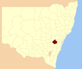
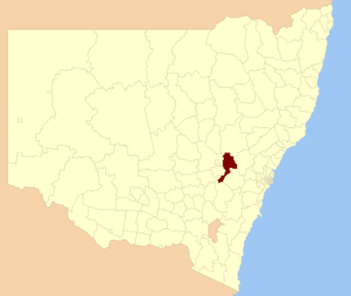
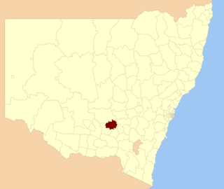
Oberon Council is a local government area in the Central West region of New South Wales, Australia. Oberon Council includes Oberon, Black Springs, Shooters Hill, Edith, O'Connell and Burraga.
Local government in Australia is the third tier of government in Australia administered by the states and territories, which in turn are beneath the federal tier. Local government is not mentioned in the Constitution of Australia and two referenda in the 1970s and 1980s to alter the Constitution relating to local government were unsuccessful. Every state government recognises local government in their respective constitutions. Unlike Canada or the United States, there is only one level of local government in each state, with no distinction such as cities and counties.
New South Wales is a state on the east coast of Australia. It borders Queensland to the north, Victoria to the south, and South Australia to the west. Its coast borders the Tasman Sea to the east. The Australian Capital Territory is an enclave within the state. New South Wales' state capital is Sydney, which is also Australia's most populous city. In September 2018, the population of New South Wales was over 8 million, making it Australia's most populous state. Just under two-thirds of the state's population, 5.1 million, live in the Greater Sydney area. Inhabitants of New South Wales are referred to as New South Welshmen.
Australia, officially the Commonwealth of Australia, is a sovereign country comprising the mainland of the Australian continent, the island of Tasmania and numerous smaller islands. It is the largest country in Oceania and the world's sixth-largest country by total area. The neighbouring countries are Papua New Guinea, Indonesia and East Timor to the north; the Solomon Islands and Vanuatu to the north-east; and New Zealand to the south-east. The population of 25 million is highly urbanised and heavily concentrated on the eastern seaboard. Australia's capital is Canberra, and its largest city is Sydney. The country's other major metropolitan areas are Melbourne, Brisbane, Perth and Adelaide.
The Mayor of Oberon Council is Cr. Kathy Sajowitz, an unaligned politician.
In many countries, a mayor is the highest-ranking official in a municipal government such as that of a city or a town.
A Councillor is a member of a local government council.
According to the Australian Bureau of Statistics there: [3]
The Australian Bureau of Statistics (ABS) is the independent statistical agency of the Government of Australia. The ABS provides key statistics on a wide range of economic, population, environmental and social issues, to assist and encourage informed decision making, research and discussion within governments and the community.
Oberon Council is composed of nine Councillors elected proportionally as a single ward. All Councillors are elected for a fixed four-year term of office. The Mayor is elected by the Councillors at the first meeting of the Council. The most recent election was due to be held on 8 September 2012. However, only nine candidates, being the below, nominated for election. There being no additional candidates, the election was uncontested. The makeup of the Council is as follows: [4]
The single transferable vote (STV) is a voting system designed to achieve proportional representation through ranked voting in multi-seat organizations or constituencies. Under STV, an elector (voter) has a single vote that is initially allocated to their most preferred candidate. Votes are totalled and a quota derived. If their candidate achieves quota, he/she is elected and in some STV systems any surplus vote is transferred to other candidates in proportion to the voters' stated preferences. If more candidates than seats remain, the bottom candidate is eliminated with his/her votes being transferred to other candidates as determined by the voters' stated preferences. These elections and eliminations, and vote transfers if applicable, continue until there are only as many candidates as there are unfilled seats. The specific method of transferring votes varies in different systems.
Party | Councillors | |
---|---|---|
Independents and Unaligned | 9 | |
Total | 9 |
The current Council, elected in 2012, in alphabetical order, is: [4]
Councillor | Party | Notes | |
---|---|---|---|
Ian Doney | Unaligned | ||
Jill Evans | Independent | ||
Neil Francis | Independent | ||
Kerry Gibbons | Independent | Deputy Mayor [5] | |
Sam Lord | Independent | ||
Clive McCarthy | Independent | ||
John McMahon | Independent | Mayor [5] | |
John Morgan | Independent | ||
Kathy Sajowitz | Unaligned |
A 2015 review of local government boundaries recommended that the Oberon merge with the Bathurst Region to form a new council with an area of 7,443 square kilometres (2,874 sq mi) and support a population of approximately 47,000. [6] The outcome of an independent review is expected to be completed by mid–2016.
The Bathurst Region is a local government area in the Central West region of New South Wales, Australia. The area is located adjacent to the Great Western Highway, Mid-Western Highway, Mitchell Highway and the Main Western railway line. At the 2016 census, the Bathurst Region had a population of 41,300.
The City of Lake Macquarie is a local government area in the Hunter Region of New South Wales, Australia and was proclaimed as a city from 7 September 1984. The area is situated adjacent to the city of Newcastle and is part of the Greater Newcastle Area. It was proclaimed as a city from 7 September 1984. The city is approximately 150 km (93 mi) north of Sydney. One of its major tourist attractions is its lake, also named Lake Macquarie.
Oberon is a town located within the Oberon Council local government area, in the central tablelands region of New South Wales, Australia. The main industries are farming, forestry and wood products. The town usually receives snowfall during the winter months, owing to its high elevation. At the 2016 census, Oberon had a population of 3,256 people.
Upper Lachlan Shire is a local government area in the Southern Tablelands region of New South Wales, Australia. The Shire was formed in February 2004 from Crookwell Shire and parts of Mulwaree, Gunning and Yass Shires.
Greater Hume Shire is a local government area in the Riverina region of southern New South Wales, Australia. The Shire was formed in 2004 incorporating Culcairn Shire, the majority of Holbrook Shire and part of Hume Shire. The shire had an estimated population of 10,137 as at 2012.
The Municipality of Burwood is a local government area in the inner-west of Sydney, in the state of New South Wales, Australia.
The Lane Cove Council is a local government area located on the Lower North Shore of Sydney, New South Wales, Australia. The administrative seat of Lane Cove is located 10 kilometres (6.2 mi) north-west of the Sydney central business district.
Leeton Shire is a local government area in the Riverina region of New South Wales, Australia. The Shire is located adjacent to the Murrumbidgee River and falls within the Murrumbidgee Irrigation Area.
Weddin Shire is a local government area in the Central West region of New South Wales, Australia. The shire's major town is Grenfell and it also includes the small towns of Caragabal, Greenethorpe and Quandialla.
Lachlan Shire is a local government area in the Central West region of New South Wales, Australia. The Shire is located adjacent to the Lachlan River, the Lachlan Valley Way and the Broken Hill railway line.
Ballina Shire is a local government area in the Northern Rivers region of New South Wales, Australia. The Shire was formed in 1976 by the amalgamation of the Municipality of Ballina and Tintenbar Shire. The Shire is located adjacent to the Tasman Sea and the Pacific Highway. The Council seat is located in the town of Ballina.
City of Wagga Wagga is a local government area in the Riverina region of south-western New South Wales, Australia.
The City of Lithgow is a local government area in the Central West region of New South Wales, Australia. The area is located adjacent to the Great Western Highway and the Main Western railway line.
Parkes Shire is a local government area in the Central West region of New South Wales, Australia. The Shire is located adjacent to the Broken Hill railway line and the Newell Highway.
Uralla Shire is a local government area located in the New England region of New South Wales, Australia. The New England Highway passes through the Shire.
Glen Innes Severn is a local government area in the New England region of New South Wales, Australia. The council serves an area of 5,487 square kilometres (2,119 sq mi) and is located adjacent to the New England Highway. The council was formed by the amalgamation of Severn Shire and Glen Innes City Council.
Temora Shire is a local government area in the Riverina region of New South Wales, Australia. It is on Burley Griffin Way. The Shire was created on 1 January 1981 via the amalgamation of Narraburra Shire and the Municipality of Temora.
Balranald Shire is a local government area in the Riverina area of western New South Wales, Australia on the Sturt Highway. It is the location of World Heritage listed Mungo National Park. It includes the towns of Balranald and Euston. Other localities in the Shire include Kyalite, Hatfield, Penarie, Clare and Oxley.
Murrumbidgee Council is a local government area in the Riverina region of New South Wales, Australia. This area was formed in 2016 from the merger of the Murrumbidgee Shire with the neighbouring Jerilderie Shire.
The Snowy Valleys Council is a local government area located in the South West Slopes region of New South Wales, Australia. This area was formed in 2016 from the merger of the Tumut Shire with the neighbouring Tumbarumba Shire.