Waverley Municipal Council

Last updated

Waverley Municipal Council
New South Wales
Waverley lga sydney.png
Location in Metropolitan Sydney
Coordinates 33°54′S151°16′E / 33.900°S 151.267°E / -33.900; 151.267 Coordinates: 33°54′S151°16′E / 33.900°S 151.267°E / -33.900; 151.267
Population
 • Density7,400/km2 (19,200/sq mi)
Established16 June 1859
Area9 km2 (3.5 sq mi)
MayorJohn Wakefield
Council seat Waverley Council Chambers
Region Metropolitan Sydney
State electorate(s)
Federal Division(s) Wentworth
Waverley Council Logo.jpg
Website Waverley Municipal Council
LGAs around Waverley Municipal Council:
Woollahra
Sydney Waverley Municipal Council Tasman Sea
Randwick

Waverley Municipal Council (or Waverley Council) is a Local government area (LGA) in the eastern suburbs of Sydney, in the state of New South Wales, Australia. There are four wards within Waverley LGA namely Bondi, Hunter, Lawson, and Waverley. [3]

Local government in Australia is the third tier of government in Australia administered by the states and territories, which in turn are beneath the federal tier. Local government is not mentioned in the Constitution of Australia and two referenda in the 1970s and 1980s to alter the Constitution relating to local government were unsuccessful. Every state government recognises local government in their respective constitutions. Unlike Canada or the United States, there is only one level of local government in each state, with no distinction such as cities and counties.

Eastern Suburbs (Sydney) Region in New South Wales, Australia

The Eastern Suburbs is the metropolitan region directly to the east and south-east of the central business district in Sydney, New South Wales, Australia.

Sydney City in New South Wales, Australia

Sydney is the state capital of New South Wales and the most populous city in Australia and Oceania. Located on Australia's east coast, the metropolis surrounds Port Jackson and extends about 70 km (43.5 mi) on its periphery towards the Blue Mountains to the west, Hawkesbury to the north, the Royal National Park to the south and Macarthur to the south-west. Sydney is made up of 658 suburbs, 40 local government areas and 15 contiguous regions. Residents of the city are known as "Sydneysiders". As of June 2017, Sydney's estimated metropolitan population was 5,230,330 and is home to approximately 65% of the state's population.

Contents

The current Mayor of Waverley Municipal Council is Cr. John Wakefield, a member of the Labor Party.

In many countries, a mayor is the highest-ranking official in a municipal government such as that of a city or a town.

A Councillor is a member of a local government council.

The Australian Labor Party , also known as NSW Labor, is the New South Wales branch of the Australian Labor Party. The parliamentary leader is elected from and by the members of the party caucus, comprising all party members in the Legislative Assembly and Legislative Council. The party factions have a strong influence on the election of the leader. The leader's position is dependent on the continuing support of the caucus and the leader may be deposed by failing to win a vote of confidence of parliamentary members. By convention, the premier sits in the Legislative Assembly, and is the leader of the party controlling a majority in that house. The party leader also typically is a member of the Assembly, though this is not a strict party constitutional requirement. Barrie Unsworth, for example, was elected party leader while a member of the Legislative Council. He then transferred to the Assembly by winning a seat at a by-election.

Suburbs and localities in the local government area

Bondi Beach Bondi Beach.jpg
Bondi Beach
Diamond Bay from Vaucluse Dover Heights, New South Wales 1.6.jpg
Diamond Bay from Vaucluse
The eastern suburbs sitting on a cliff. Sydneycityscape.jpg
The eastern suburbs sitting on a cliff.
Aerial view of clifftop neighbourhood in Dover Heights. Dover Heights cliff-top homes (Sydney, Australia).png
Aerial view of clifftop neighbourhood in Dover Heights.

Suburbs serviced by Waverley Council are:

Bondi is an eastern suburb of Sydney, in the state of New South Wales, Australia, seven kilometres east of the Sydney central business district, in the local government area of Waverley Council.

Bondi Junction, New South Wales Suburb of Sydney, New South Wales, Australia

Bondi Junction is an eastern suburb of Sydney, in the state of New South Wales, Australia. It is 6 kilometres east of the Sydney central business district and is part of the local government area of the Waverley.

Bronte, New South Wales Suburb of Sydney, New South Wales, Australia

Bronte is a beachside suburb of Sydney, in the state of New South Wales, Australia. Bronte beach is located 7 kilometres east of the Sydney central business district, in the Waverley Council local government area of the Eastern Suburbs.

These localities are also serviced by Waverley Council:

Ben Buckler, New South Wales locality in eastern Sydney, NSW, Australia

Ben Buckler is an urban locality in eastern Sydney, in the state of New South Wales, Australia. It is part of the suburb of North Bondi and the local government area of Waverley Council in the Eastern Suburbs.. It is sometimes referred to simply as "the northern headland of Bondi Bay."

Charing Cross, New South Wales New South Wales, Australia

Charing Cross is a precinct in the suburb of Waverley, part of eastern Sydney, in the state of New South Wales, Australia. The name "Charing Cross" is used to describe the intersection of Bronte Road and Carrington Road and the short shopping strip extending to the east along Bronte Road, and is used as a reference point for the homes and schools located around it.

Note: On 6 October 1944, the recommendation to remove the Mill Hill area (37 acres) from the Randwick LGA and include it in the Waverley LGA was proclaimed in the NSW Government Gazette. The recommendation was the result of a 1941 NSW Local Government Department Commission of Inquiry. [4]

History

On 11 November 1858 a petition for the incorporation of the Municipality of Waverley under the terms of the Municipalities Act of 1858 was presented to the Governor of New South Wales, Sir William Denison and a second petition was presented to Denison on 17 May 1859. [5] Denison approved the proclamation establishing the Municipality of Waverley on 13 June 1859, and it was subsequently published in the New South Wales Government Gazette on 16 June 1859. [6] [7] The first returning officer, Charles St Julian, was appointed to conduct the first meeting of electors. [8]

Governor of New South Wales vice-regal representative of the Australian monarch in New South Wales

The Governor of New South Wales is the viceregal representative of the Australian monarch, Queen Elizabeth II, in the state of New South Wales. In an analogous way to the Governor-General of Australia at the national level, the Governors of the Australian states perform constitutional and ceremonial functions at the state level. The governor is appointed by the queen on the advice of the premier of New South Wales, for an unfixed period of time—known as serving At Her Majesty's pleasure—though five years is the norm. The current governor is retired General David Hurley, who succeeded Dame Marie Bashir on 2 October 2014.

William Denison British colonial administrator

Sir William Thomas Denison was Lieutenant Governor of Van Diemen's Land from 1847 to 1855, Governor of New South Wales from 1855 to 1861, and Governor of Madras from 1861 to 1866.

Charles St Julian Australian journalist and Chief Justice of Fiji

Charles James Herbert de Courcy St Julian was a journalist, newspaper owner-editor and the first Chief Justice of Fiji.

Council Chambers

The first Council meeting was held on 16 June 1859, but there was no permanent office for the conduct of Council duties some early meetings were held in the Charing Cross Hotel and others in the old School of Arts building in Bronte Road. [9] In December 1860 the Council accepted an offer from Francis O'Brien to donate a site for a Council Chambers in Bondi Road. The cost of building was to be limited to ₤500, although approximately £700 was eventually spent. The foundation stone was laid in 1861, and a first meeting of Council was held there on 21 November 1861, the first Council building erected by any municipality under the Municipalities Act of 1858.[ citation needed ] Discussions were held during the early 1900s over the need for new Council Chambers, and in 1913 a portion of the north-west corner of Waverley Park was dedicated as the site for a new building. A report of the same year stated that the original building was too small for the staff, and had poor ventilation and lighting. It was later sold for £1,600. The new building was completed by the end of 1913, and on 6 January 1914 the Council met for the first time in the new chambers.[ citation needed ]

Parts of the 1913 chambers still form the shell of the present Council Chambers, although extensive alterations in 1962, and further development in 1976 and 1977 have altered its appearance considerably.

2016-17 amalgamation proposals

A 2015 review of local government boundaries recommended that the Municipality of Waverley merge with the Woollahra and Randwick councils to form a new council with an area of 58 square kilometres (22 sq mi) and support a population of approximately 274,000. [10] Following an independent review, in May 2016 the NSW Government sought to dismiss the Council and force its amalgamation with Woollahra and Randwick councils. Woollahra Council instigated legal action claiming that there was procedural unfairness and that a KPMG report at the centre of merger proposals had been "misleading". The matter was heard before the NSW Court of Appeal who, in December 2016, unanimously dismissed Woollahra Council's appeal, finding no merit in its arguments that the proposed merger with Waverley and Randwick councils was invalid. [11] In July 2017, the Berejiklian government decided to abandon the forced merger of the Woollahra, Waverley and Randwick local government areas, along with several other proposed forced mergers. [12]

Demographics

At the 2011 census, there were 63,487 people in Waverley, of these 49.2% were male and 50.8% were female. Aboriginal and Torres Strait Islander people made up 0.4% of the population. The median age of people in Waverley Council was 35 years. Children aged 0 – 14 years made up 15.4% of the population and people aged 65 years and over made up 12.0% of the population. Of people in the area aged 15 years and over, 37.4% were married and 10.0% were either divorced or separated. [13]

Population growth in Waverley Council between the 2001 Census and the 2006 Census was 3.31%; and in the subsequent five years to the 2011 Census, population growth was 4.57%. When compared with total population growth of Australia for the same periods, being 5.78% and 8.32% respectively, population growth in the Waverley local government area was a little over half the national average. [14] The median weekly income for residents within the Municipality of Waverley was more than 1.5 times the national average. [13] [15]

The proportion of residents in Waverley who stated their ancestry was Jewish was three times the New South Wales and national averages. The proportion of households where Russian is spoken at home is thirteen times the state and national averages; and of all households where Hebrew is spoken in New South Wales, one third are located in Waverley, and in Australia, one tenth of households where Hebrew is spoken are located in Waverley. The proportion of residents who stated an affiliation with Judaism was in excess of twenty–eight times the state and national averages. [13]

Selected historical census data for Waverley local government area
Census year2001 [14] 2006 [15] 2011 [13] 2016 [1]
PopulationEstimated residents on census night 58,76960,71563,48766,812
LGA rank in terms of size within New South Wales36th
% of New South Wales population0.92%Decrease2.svg 0.89%
% of Australian population0.31%Steady2.svg 0.31%Decrease2.svg 0.30%Decrease2.svg 0.28%
Estimated ATSI population on census night199196245270
% of ATSI population to residents0.3%Steady2.svg 0.3%Increase2.svg 0.4%Steady2.svg 0.4%
Cultural and language diversity
Ancestry,
top responses
English 20.9%Increase2.svg 29.0%
Australian 16.1%Increase2.svg 20.8%
Irish 9.3%Increase2.svg 12.2%
Scottish 5.5%Increase2.svg 7.3%
Jewish 3.1%Decrease2.svg 2.1%
Language,
top responses
(other than English)
Russian 3.2%Decrease2.svg 2.6%Steady2.svg 2.6%Decrease2.svg 2.2%
Spanish n/cIncrease2.svg 1.0%Increase2.svg 1.3%Increase2.svg 2.1%
Portuguese n/rn/rn/rIncrease2.svg1.9%
French n/cn/cIncrease2.svg 1.3%Increase2.svg 1.8%
Italian 1.5%Increase2.svg 1.3%Increase2.svg 1.4%Increase2.svg 1.7%
Religious affiliation
Religious affiliation,
top responses
No religion, so described16.9%Increase2.svg 18.0%Increase2.svg 24.3%Increase2.svg 33.4%
Catholic 22.9%Decrease2.svg 20.8%Increase2.svg 22.1%Decrease2.svg 19.9%
Judaism 16.1%Increase2.svg 16.8%Increase2.svg 17.1%Decrease2.svg 15.1%
Religion not statedn/rn/rn/rIncrease2.svg 14.4%
Anglican 13.5%Decrease2.svg 11.7%Decrease2.svg 11.0%Decrease2.svg 7.9%
Median weekly incomes
Personal incomeMedian weekly personal incomeA$765A$973A$1,151
% of Australian median income164.2%Increase2.svg 168.6%Increase2.svg 173.9%
Family incomeMedian weekly family incomeA$1,446A$2,496A$2,917
% of Australian median income140.8%Increase2.svg 168.5%Decrease2.svg 168.2%
Household incomeMedian weekly household incomeA$1,928A$1,912A$2,308
% of Australian median income164.6%Decrease2.svg 154.9%Increase2.svg 160.5%
Dwelling structure
Dwelling type Separate house 17.9%Increase2.svg 21.2%Decrease2.svg 19.9%Decrease2.svg 16.5%
Semi-detached, terrace or townhouse 18.7%Decrease2.svg 16.7%Increase2.svg 18.8%Increase2.svg 19.0%
Flat or apartment 51.7%Increase2.svg 61.3%Decrease2.svg 60.5%Increase2.svg 62.6%

Council

NSW Local Government Elections are held every four years on the second Saturday of September as stipulated by the Local Government Act 1993. [16] [17]

Current composition and election method

Waverley Council is composed of twelve Councillors elected proportionally from the four separate wards, each electing three Councillors. All Councillors are elected for a fixed four-year term of office. The Mayor is elected by the Councillors at the first meeting of the Council for a two-year term. The most recent election was held on 9 September 2017, and the makeup of the Council is as follows:

PartyCouncillors
Liberal Party of Australia 5
Australian Labor Party 4
The Greens 3
Total12

The current Council, elected in 2017, in order of election by ward, is:

WardCouncillorPartyNotes
Bondi Ward [18] Leon Goltsman Liberal
Dominic Wy Kanak Greens Deputy Mayor
John Wakefield Labor Mayor
Hunter Ward [19] Sally Betts Liberal
Will NemeshLiberal
Steven LewisLabor
Lawson Ward [20] Angela BurrillLiberal
Elaine KeenanGreens
Paula MasselosLabor
Waverley Ward [21] Tony KayLiberal
George CopelandGreens
Marjorie O'NeillLabor

Mayors

MayorPartyTermNotes
Ernie Page LaborSeptember 1978 – September 1984 [22] [23]
James R. MarkhamIndependentSeptember 1984 – September 1985 [22]
Ray J. CollinsIndependentSeptember 1985 – September 1986 [22]
John Douglas Morrison OAM IndependentSeptember 1986 – September 1987 [24] [25]
Carolyn Ann MarkhamIndependentSeptember 1987 – September 1988 [22]
Barbara Armitage OAM LaborSeptember 1988 – September 1997 [26] [27]
Paul Pearce September 1997 – 8 April 2004 [28]
Peter Moscatt8 April 2004 – 22 September 2005 [29]
Mora MainGreens22 September 2005 – 21 September 2006 [30]
George Newhouse Labor21 September 2006 – 20 September 2007 [31]
Ingrid Strewe20 September 2007 – 30 September 2008 [32] [33]
Sally Betts Liberal30 September 2008 – 22 September 2011 [22]
John WakefieldLabor22 September 2011 – 27 September 2012 [34]
Sally Betts Liberal27 September 2012 – 26 September 2017 [35]
John WakefieldLabor26 September 2017 – date [36]

Heritage listings

The Waverley Council area has a number of heritage-listed sites, including:

Related Research Articles

City of Botany Bay Local government area in New South Wales, Australia

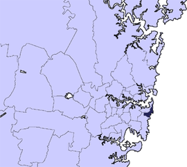
The City of Botany Bay was a local government area in the eastern region of Sydney, in the state of New South Wales, Australia. The area encompassed the suburbs to the north of Botany Bay, such as Botany. First proclaimed in 1888 as the "Borough of Botany", the council became the "Municipality of Botany" from 1906 to 1996, when it was proclaimed a city as the "City of Botany Bay".

Marrickville Council Local government area in New South Wales, Australia

Marrickville Council was a local government area located in the inner west region of Sydney, Australia. It was originally created on 1 November 1861 as the "Municipality of Marrickville". On 12 May 2016, Marrickville Council was merged with Ashfield and Leichhardt councils into the newly formed Inner West Council.

North Sydney Council Local government area in New South Wales, Australia

North Sydney Council is a local government area on the Lower North Shore of Sydney, New South Wales, Australia, established on 29 July 1890 through the amalgamation of three boroughs.

City of Randwick Local government area in New South Wales, Australia

The City of Randwick is a local government area in the eastern suburbs of Sydney, New South Wales, Australia. Established in 1859, Randwick is the second-oldest local government area in New South Wales, after the City of Sydney. It comprises an area of 36 square kilometres (14 sq mi) and as at the 2016 census had a population of 140,660.

City of Rockdale Local government area in New South Wales, Australia

The City of Rockdale was a local government area in southern and St George regions of Sydney, in the state of New South Wales, Australia. The city centre was located 12 kilometres (7.5 mi) south-west of the Sydney central business district, on the western shores of Botany Bay. First proclaimed on 13 January 1871, Rockdale was formerly known as the Municipality of West Botany until 1887 and the Municipality of Rockdale before being proclaimed as a City in 1995. Rockdale was amalgamated with the neighbouring City of Botany Bay on 9 September 2016 to form the new municipality of Bayside Council.

City of Ryde Local government area in New South Wales, Australia

The City of Ryde is a local government area that services certain suburbs located within the Northern Suburbs of Sydney, in the state of New South Wales, Australia. It was first established as the Municipal District of Ryde in 1870, became a municipality in 1906 and was proclaimed as the City of Ryde in 1992.

Municipality of Woollahra Local government area in New South Wales, Australia

Woollahra Municipal Council is a local government area in the eastern suburbs of Sydney, in the state of New South Wales, Australia. Woollahra is bounded by Sydney Harbour in the north, Waverley Council in the east, Randwick City in the south and the City of Sydney in the west.

Municipality of Alexandria Local government area in New South Wales, Australia

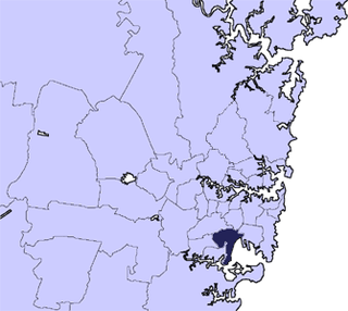
The Municipality of Alexandria was a local government area of Sydney, New South Wales, Australia. Originally part of the municipalities of Redfern from 1859 and Waterloo from 1860, the Borough of Alexandria was proclaimed on 27 August 1868. With an area of 4.2 square kilometres, it included the modern suburbs of Alexandria, Beaconsfield and parts of Eveleigh, St Peters and Erskineville. After a minor boundary change with the Municipality of Erskineville in 1908, the council was amalgamated with the City of Sydney, along with most of its neighbours, with the passing of the Local Government (Areas) Act 1948, although the former council area was later transferred in 1968–1982 and 1989–2004 to the South Sydney councils.

The Coonabarabran Shire was a local government area in the Orana region of New South Wales, Australia. The Shire was proclaimed on 7 March 1906 with the enactment of the Local Government (Shires) Act 1905 and was centred on the town of Coonabarabran, but also covered a wide area extending to smaller towns, such as Baradine and Binnaway. On 25 August 2004, the Shire voluntarily amalgamated with the adjoining Coolah Shire to form the Warrumbungle Shire.

Municipality of Newtown Local government area in New South Wales, Australia

The Municipality of Newtown was a local government area of Sydney, New South Wales, Australia. The municipality was proclaimed as a borough in 1862 and, with an area of 1.9 square kilometres, was centred on the suburb of Newtown, including parts of Erskineville and Enmore. The municipality was divided into four wards: Kingston, Enmore, O'Connell and Camden. In 1949 under the Local Government (Areas) Act 1948, Newtown Municipal Council was merged with the larger neighbouring City of Sydney which was located immediately to the North, although parts were subsequently, from 1968, moved into Marrickville Council. Mayors included Lilian Fowler (1938–1939), the first female mayor in Australia.

Municipality of Redfern Local government area in New South Wales, Australia

The Municipality of Redfern was a local government area of Sydney, New South Wales, Australia. The small municipality was proclaimed in 1859 as one of the first municipalities proclaimed under the new provisions of the Municipalities Act, 1858, and was centred on the suburbs of Redfern, Eveleigh, Darlington and Surry Hills. The council was amalgamated, along with most of its neighbours, with the City of Sydney to the north with the passing of the Local Government (Areas) Act 1948. From 1968 to 1982 and from 1989 to 2004, the area was part of the South Sydney councils.

William Walker was an Australian politician and yachtsman.

Municipality of Darlington Local government area in New South Wales, Australia

The Municipality of Darlington was a local government area of Sydney, New South Wales, Australia. The municipality was proclaimed in 1864 and, with an area of 0.2 square kilometres, was the smallest municipal council in Sydney. It included the entire suburb of Darlington, excepting a small block between Golden Grove and Forbes streets, which was administered by the Municipality of Redfern in Golden Grove Ward. The council was amalgamated, along with most of its neighbours, with the City of Sydney to the north with the passing of the Local Government (Areas) Act 1948. From 1968 to 1982 and from 1989 to 2004, the area was part of the South Sydney councils.

Municipality of Annandale Local government area in New South Wales, Australia

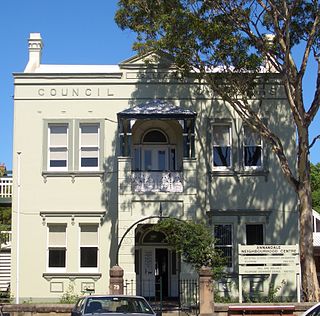
The Municipality of Annandale was a local government area of Sydney, New South Wales, Australia. The municipality was proclaimed on 29 December 1893 as the Borough of Annandale when the East Ward of Leichhardt Council separated, and, with an area of 1.4 square kilometres, covered the entire suburb of Annandale, excepting a small block between Johnstons Creek, Booth Street and Parramatta Road. The council was amalgamated with the Municipality of Leichhardt to the west with the passing of the Local Government (Areas) Act 1948.

The Municipality of Balmain was a local government area of Sydney, New South Wales, Australia. The municipality was proclaimed in February 1860 and, with an area of 3.8 square kilometres, covered the entire peninsula of Balmain north of Callan Park and Foucart Street, including the present suburbs of Balmain, Balmain East, Birchgrove and Rozelle. The council was amalgamated with the municipalities of Leichhardt and Annandale to the south with the passing of the Local Government (Areas) Act 1948.

Municipality of Waterloo Local government area in New South Wales, Australia

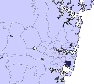
The Municipality of Waterloo was a local government area of Sydney, New South Wales, Australia. The municipality was proclaimed on 16 May 1860 and, with an area of 3.4 square kilometres, included the modern suburbs of Waterloo, Zetland and Rosebery. The suburb of Alexandria was originally included as the Western Ward of the council but seceded as a separate municipality in 1868. After several attempts to amalgamate with various neighbours in the mid-1920s, the council was amalgamated with the City of Sydney, along with most of its neighbours, with the passing of the Local Government (Areas) Act 1948, although parts of the former council area were transferred in 1967 to the City of South Sydney.

Municipality of Enfield (New South Wales) Local government area in New South Wales, Australia

The Municipality of Enfield was a local government area of Sydney, New South Wales, Australia. The municipality was proclaimed as the Borough of Enfield on 17 January 1889 and, with an area of 3.6 square kilometres, included the modern suburbs of Croydon, Croydon Park and Strathfield South, with parts of Enfield, Belfield and Greenacre included in the West Ward. In 1949, the council was split into two, with Central and East Wards being added to the Municipality of Burwood and the West Ward being added into the Municipality of Strathfield, with the passing of the Local Government (Areas) Act 1948.

Municipality of Paddington Local government area in New South Wales, Australia

The Municipality of Paddington was a local government area of Sydney, New South Wales, Australia. The municipality was proclaimed on 17 April 1860 and, with an area of 1.7 square kilometres, included the entire suburb of Paddington and parts of Edgecliff. The council was amalgamated with the City of Sydney to the east with the passing of the Local Government (Areas) Act 1948, although the former council area was transferred in 1968 to the Municipality of Woollahra, transferred to the City of South Sydney in 1989 and was then split in 2003 between the City of Sydney and the Municipality of Woollahra.

The Municipality of Windsor was a local government area of Greater Western Sydney, New South Wales, Australia. The municipality was proclaimed as the Borough of Windsor on 4 March 1871 and was centred on the Town of Windsor. In 1949, with the passing of the Local Government (Areas) Act 1948, the council doubled in size with the amalgamation of the Municipality of Richmond to the west. On 1 January 1981, Windsor merged with the Colo Shire Council to the north, forming the Hawkesbury Shire.

References

  1. 1 2 Australian Bureau of Statistics (27 June 2017). "Waverley (A)". 2016 Census QuickStats. Retrieved 15 January 2018. Blue pencil.svg
  2. "3218.0 – Regional Population Growth, Australia, 2017-18". Australian Bureau of Statistics. 27 March 2019. Retrieved 27 March 2019. Estimated resident population (ERP) at 30 June 2018.
  3. "Electoral Commission NSW - Waverley Council".
  4. DOWD, B.T (Bernard Thomas) (1959). The history of the Waverley Municipal District : published by the Council of the Municipality of Waverley (New South Wales) to commemorate its centenary of municipal government (1859-1959) - also known as The Centenary of the Municipality of Waverley,1859-1959 (PDF). Waverley, N.S.W. : Municipal Council. p. 83.
  5. "Municipalities Act of 1858 (22 Vic. No. 13)" (PDF).
  6. "MUNICIPALITY OF WAVERLEY". New South Wales Government Gazette (115). New South Wales, Australia. 16 June 1859. p. 1344. Retrieved 29 March 2019 via National Library of Australia.
  7. DOWD, B.T (Bernard Thomas) (1959). The history of the Waverley Municipal District : published by the Council of the Municipality of Waverley (New South Wales) to commemorate its centenary of municipal government (1859-1959) (PDF). Waverley, N.S.W. : Municipal Council. pp. IV - V and pages 50–58.
  8. DOWD, B.T (Bernard Thomas) (1959). The history of the Waverley Municipal District : published by the Council of the Municipality of Waverley (New South Wales) to commemorate its centenary of municipal government (1859-1959) (PDF). Waverley, N.S.W. : Municipal Council. p. 59.
  9. "Waverley Council Chambers" (PDF). Waverley Council. Retrieved 5 November 2015.
  10. "Merger proposal: Randwick City Council, Waverley Council, Woollahra Municipal Council" (PDF). Government of New South Wales. January 2016. p. 7. Retrieved 4 March 2016.
  11. Visentin, Lisa (22 December 2016). "Woollahra loses merger appeal, hints at High Court challenge". The Sydney Morning Herald . Retrieved 31 December 2016.
  12. Blumer, Clare; Chettle, Nicole (27 July 2017). "NSW council amalgamations: Mayors fight to claw back court dollars after backflip on merger". ABC News . Australia. Retrieved 27 July 2017.
  13. 1 2 3 4 Australian Bureau of Statistics (31 October 2012). "Waverley (A)". 2011 Census QuickStats. Retrieved 11 November 2012. Blue pencil.svg
  14. 1 2 Australian Bureau of Statistics (9 March 2006). "Waverley (A)". 2001 Census QuickStats. Retrieved 11 November 2012.
  15. 1 2 Australian Bureau of Statistics (25 October 2007). "Waverley (A)". 2006 Census QuickStats. Retrieved 11 November 2012.
  16. "Local Government". Electoral Commission NSW.
  17. "NSW Legislation - Local Government Act 1993 No 30". Government of New South Wales.
  18. "Waverley Council - Bondi Ward". Local Government Elections 2012. Electoral Commission of New South Wales. 15 September 2012. Retrieved 20 September 2012.
  19. "Waverley Council - Hunter Ward". Local Government Elections 2012. Electoral Commission of New South Wales. 15 September 2012. Retrieved 20 September 2012.
  20. "Waverley Council - Lawson Ward". Local Government Elections 2012. Electoral Commission of New South Wales. 15 September 2012. Retrieved 20 September 2012.
  21. "Waverley Council - Waverley Ward". Local Government Elections 2012. Electoral Commission of New South Wales. 15 September 2012. Retrieved 20 September 2012.
  22. 1 2 3 4 5 "The Mayors of Waverley Council" (PDF). Waverley Council. Retrieved 29 March 2019.
  23. "Councillors of Waverley, 1859 - 2009" (PDF). Waverley Council. Retrieved 29 March 2019.
  24. Father of Scott Morrison, Prime Minister of Australia.
  25. "Mr John Douglas MORRISON - Medal of the Order of Australia". It's an Honour database. Australian Government. 14 June 2004. Retrieved 29 March 2019. For service to the community of eastern Sydney, particularly through youth, church, amateur theatre and service groups.
  26. "Armitage, Barbara". The Australian Women's Register. Australian Women's Archives Project. Retrieved 29 March 2019.
  27. "Ms Barbara Jean ARMITAGE - Medal of the Order of Australia". It's an Honour database. Australian Government. 10 June 2002. Retrieved 29 March 2019. For service to local government, to the reduction of water pollution through the establishment of Sydney Coastal Councils and BeachWatch, and to the community.
  28. "Paul Pearce Re-elected Mayor". Waverley Council. 24 September 1998. Archived from the original (Media Release) on 23 October 1999. Retrieved 29 March 2019.
  29. "Minutes of the Council Meeting held on Thursday, 8 April 2004". Waverley Council. 8 April 2004. Archived from the original on 26 August 2004. Retrieved 29 March 2019.
  30. "Cr Mora Main Elected As Waverley's New Mayor". Waverley Council. 22 September 2005. Archived from the original (Media Release) on 1 August 2008. Retrieved 29 March 2019.
  31. "Human Rights Lawyer elected as new Waverley Mayor". Waverley Council. 22 September 2006. Archived from the original (Media Release) on 1 August 2008. Retrieved 29 March 2019.
  32. "Ingrid Strewe elected as new Waverley Mayor". Waverley Council. 20 September 2007. Archived from the original (Media Release) on 29 July 2008. Retrieved 29 March 2019.
  33. Laughlin, Shaya (9 August 2017). "Cr Strewe steps down after 13 years". Wentworth Courier. Retrieved 29 March 2019.
  34. "Council News Mayor's Column Mayor's Column Items 2011- Weekly Columns in the Wentworth Courier Wednesday, 5 October". Waverley Council. Archived from the original on 24 March 2012. Retrieved 29 March 2019.
  35. Davies, Anne (18 March 2016). "Sally Betts: the Waverley mayor who rules Sydney's east". The Sydney Morning Herald. Retrieved 29 March 2019.
  36. Laughlin, Shaya (27 September 2017). "Labor's John Wakefield is Waverley Council's new mayor". Wentworth Courier. Retrieved 29 March 2019.
  37. "Electricity Substation No. 269". New South Wales State Heritage Register . Office of Environment and Heritage. H01791. Retrieved 18 May 2018.
  38. "BOOS (Bondi Ocean Outfall Sewer)". New South Wales State Heritage Register . Office of Environment and Heritage. H01623. Retrieved 18 May 2018.
  39. "St. Anne's Church". New South Wales State Heritage Register . Office of Environment and Heritage. H01706. Retrieved 18 May 2018.
  40. "Sewer Vent (Ben Buckler)". New South Wales State Heritage Register . Office of Environment and Heritage. H01637. Retrieved 18 May 2018.
  41. "Bondi Beach Cultural Landscape". New South Wales State Heritage Register . Office of Environment and Heritage. H01786. Retrieved 18 May 2018.
  42. "Waverley Reservoir (Elevated) (WS 0136)". New South Wales State Heritage Register . Office of Environment and Heritage. H01646. Retrieved 18 May 2018.
  43. "Waverley Reservoir No.1 (WS 0132)". New South Wales State Heritage Register . Office of Environment and Heritage. H01353. Retrieved 18 May 2018.
  44. "Bronte House". New South Wales State Heritage Register . Office of Environment and Heritage. H00055. Retrieved 18 May 2018.
  45. "Waverley Cemetery". New South Wales State Heritage Register . Office of Environment and Heritage. H01975. Retrieved 18 May 2018.
  46. "Ben Buckler Gun Battery 1893, 9.2 Disappearing Gun". New South Wales State Heritage Register . Office of Environment and Heritage. H01742. Retrieved 18 May 2018.
  47. "South Head General Cemetery". New South Wales State Heritage Register . Office of Environment and Heritage. H01991. Retrieved 18 May 2018.
  48. "St. Mary's Anglican Church and Pipe Organ". New South Wales State Heritage Register . Office of Environment and Heritage. H00160. Retrieved 18 May 2018.
  49. "Charing Cross". New South Wales State Heritage Register . Office of Environment and Heritage. H00449. Retrieved 18 May 2018.
  50. "Mary Immaculate Group". New South Wales State Heritage Register . Office of Environment and Heritage. H00626. Retrieved 18 May 2018.