Ransome, Queensland

Last updated

Ransome
Brisbane,  Queensland
Mookin-Bah Reserve 2018.jpg
Mookin-Bah Reserve, 2018
Australia Queensland location map.svg
Red pog.svg
Ransome
Ransome, Queensland
Coordinates 27°29′09″S153°10′49″E / 27.4859°S 153.1802°E / -27.4859; 153.1802 (Ransome (centre of suburb))
Population429 (2021 census) [1]
 • Density89.4/km2 (231.5/sq mi)
Established1975
Postcode(s) 4154
Area4.8 km2 (1.9 sq mi)
Time zone AEST (UTC+10:00)
Location19.6 km (12 mi) E of Brisbane CBD
LGA(s) City of Brisbane
(Chandler Ward) [2]
State electorate(s) Chatsworth
Federal division(s) Bonner
Suburbs around Ransome:
Wakerley Lota Lota
Wakerley Ransome Thorneside
Gumdale Chandler Birkdale

Ransome is an outer coastal suburb in the City of Brisbane, Queensland, Australia. [3] In the 2021 census, Ransome had a population of 429 people. [1]

Contents

Geography

Ransome is 19.6 kilometres (12 mi) by road east of the Brisbane CBD. It is on the boundary with the City of Redland. [4]

Ransome is bounded to the north by Moreton Bay, to the east by Tingalpa Creek, to the south by Chadwell Street and to the west loosely by Lota Creek. [4]

Rickertt Road enters the suburb from the west (Wakerley) and travels straight east through the suburb and exits to the east (Thornside); it is the only through road in the suburb. Molle Road enters the suburb from the south-west (Gumdale) and travels straight east through the suburb, terminating at the boundary of the locality at Tingalpa Creek. Chelsea Road enters the suburb from the south (Gumdale/Chandler) and travels straight north terminating at Lota Creek. [4]

There are two separate residential areas in Ransome, one on Rickertt Road ( 27°29′11″S153°10′51″E / 27.4865°S 153.1809°E / -27.4865; 153.1809 (Residential area (Rickertt Road)) ) and the other on Molle Road ( 27°29′42″S153°10′45″E / 27.4949°S 153.1792°E / -27.4949; 153.1792 (Residential area (Molle Road)) ). The remainder of the land is undeveloped. [4]

Molle Road Molle Road, Ransome.jpg
Molle Road
Rickertt Road Rickertt Road, Ransome.jpg
Rickertt Road

Tingalpa Creek Conservation Park is beside Molle Road and Tingalpa Creek ( 27°29′44″S153°11′11″E / 27.4955°S 153.1863°E / -27.4955; 153.1863 (Tingalpa Creek Conservation Park) ). [5]

The Cleveland railway line passes through the suburb from the north (Lota) to the north-east (Thorneside). It travels through undeveloped bushland and there is no railway station servicing the suburb. [4]

Although the suburb does border Moreton Bay, the area near the coast is undeveloped land (Ransome Reserve) and includes two unnamed islands. Although there are walking tracks through the reserve, they do not extend past the railway line to the bay. [4] [6]

History

Ransome was named after Charles Horace Ransome who lived in the area and had a sawmill, supplying mixed firewood to the city and the Queensland Railways Department. [3] [7] [8] At the time of his death in November 1948, he was living in Keyes Street, Lota, immediately north of Lota Creek. [9]

On 11 August 1975, the area was officially named and bounded by the Queensland Place Names Board. [3]

Demographics

In the 2011 census, Ransome had a population of 474 people, 50% female and 50% male. The median age of the Ransome population was 39 years, 2 years above the Australian median. 73.4% of people living in Ransome were born in Australia, compared to the national average of 69.8%; the next most common countries of birth were England 6.8%, New Zealand 6.1%, Germany 1.5%, Taiwan 0.8%, Austria 0.8%. 88.2% of people spoke only English at home; the next most common languages were 2.5% German, 1.5% Persian (excluding Dari), 0.8% Mandarin, 0.6% Dutch, 0.6% Danish. [10]

In the 2016 census, Ransome had a population of 405 people. [11]

In the 2021 census, Ransome had a population of 429 people. [1]

Education

There are no schools in Ransome. The nearest primary school is Gumdale State School in Gumdale to the south-west. The nearest secondary schools are Wellington Point State High School in Wellington Point to the east, Capalaba State College in Capalaba to the south, and Wynnum State High School in Wynnum to the north. [4]

Amenities

There are a number of parks in the suburb:

Related Research Articles

<span class="mw-page-title-main">Thorneside railway station</span> Railway station in Brisbane, Queensland

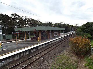
Thorneside railway station is located on the Cleveland line in Queensland, Australia. It serves the suburb of Thorneside in Redland City.

<span class="mw-page-title-main">Capalaba, Queensland</span> Suburb of Redland City, Queensland, Australia

Capalaba is an urban locality in the City of Redland, Queensland, Australia. In the 2021 census, Capalaba had a population of 18,002 people.

<span class="mw-page-title-main">Tingalpa, Queensland</span> Suburb of Brisbane, Queensland, Australia

Tingalpa is a suburb in the City of Brisbane, Queensland, Australia. In the 2021 census, Tingalpa had a population of 8,461 people.

MacGregor is a southern suburb in the City of Brisbane, Queensland, Australia. In the 2021 census, MacGregor had a population of 5,980 people.

<span class="mw-page-title-main">Carindale, Queensland</span> Suburb of Brisbane, Queensland, Australia

Carindale is a suburb of the City of Brisbane, Queensland, Australia. It is located 13.1 kilometres (8.1 mi) by road south-east of the Brisbane GPO, and borders Belmont, Carina, Carina Heights, Mackenzie, Mansfield, Mount Gravatt East, and Tingalpa. In the 2021 census, Carindale had a population of 16,535 people.

<span class="mw-page-title-main">Burbank, Queensland</span> Suburb of Brisbane, Queensland, Australia

Burbank is a greenbelt suburb in the City of Brisbane, Queensland, Australia. In the 2021 census, Burbank had a population of 1,051 people.

<span class="mw-page-title-main">Priestdale, Queensland</span> Suburb of Logan City, Queensland, Australia

Priestdale is a suburb in the north-west of the City of Logan, Queensland, Australia. In the 2021 census, Priestdale had a population of 160 people.

<span class="mw-page-title-main">Thorneside, Queensland</span> Suburb of Redland City, Queensland, Australia

Thorneside is a coastal urban locality in the City of Redland, Queensland, Australia. In the 2021 census, Thorneside had a population of 3,877 people.

<span class="mw-page-title-main">Wishart, Queensland</span> Suburb of Brisbane, Queensland, Australia

Wishart is a southern suburb in the City of Brisbane, Queensland, Australia. In the 2021 census, Wishart had a population of 11,333 people.

<span class="mw-page-title-main">Chandler, Queensland</span> Suburb of Brisbane, Queensland, Australia

Chandler is an outer south-eastern suburb in the City of Brisbane, Queensland, Australia. In the 2021 census, Chandler had a population of 1,475 people.

<span class="mw-page-title-main">Belmont, Queensland</span> Suburb of Brisbane, Queensland, Australia

Belmont is an outer suburb in the City of Brisbane, Queensland, Australia. In the 2021 census, Belmont had a population of 4,498 people.

<span class="mw-page-title-main">Gumdale, Queensland</span> Suburb of Brisbane, Queensland, Australia

Gumdale is an outer suburb of the City of Brisbane, Queensland, Australia. In the 2021 census, Gumdale had a population of 2,298 people.

<span class="mw-page-title-main">Manly West, Queensland</span> Suburb of Brisbane, Queensland, Australia

Manly West is a suburb in the City of Brisbane, Queensland, Australia. In the 2021 census, Manly West had a population of 12,436 people.

<span class="mw-page-title-main">Lota, Queensland</span> Suburb of Brisbane, Queensland, Australia

Lota is an eastern bayside suburb in the City of Brisbane, Queensland, Australia. In the 2021 census, Lota had a population of 3,518 people.

<span class="mw-page-title-main">Karawatha, Queensland</span> Suburb of Brisbane, Queensland, Australia

Karawatha is an outer southern suburb in the City of Brisbane, Queensland, Australia. In the 2021 census, Karawatha had a population of 337 people.

<span class="mw-page-title-main">Hemmant, Queensland</span> Suburb of Brisbane, Queensland, Australia

Hemmant is a eastern riverside suburb of the City of Brisbane, Queensland, Australia. In the 2021 census, Hemmant had a population of 2,886 people.

<span class="mw-page-title-main">Upper Kedron, Queensland</span> Suburb of Brisbane, Queensland, Australia

Upper Kedron is a outer north-western suburb in the City of Brisbane, Queensland, Australia. In the 2021 census, Upper Kedron had a population of 5,800 people.

<span class="mw-page-title-main">Pallara, Queensland</span> Suburb of Brisbane, Queensland, Australia

Pallara is an outer southern suburb in the City of Brisbane, Queensland, Australia. In the 2021 census, Pallara had a population of 3,861 people.

<span class="mw-page-title-main">Sheldon, Queensland</span> Suburb of Redland City, Queensland, Australia

Sheldon is a rural residential locality in the City of Redland, Queensland, Australia. In the 2021 census, Sheldon had a population of 1,762 people.

<span class="mw-page-title-main">Mount Cotton Road</span>

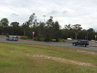
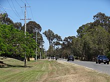
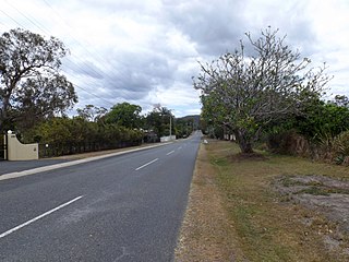
Mount Cotton Road, or Mt Cotton Rd, is a major split road in the Brisbane area of South East Queensland, Australia. It runs in both an east-west direction between Burbank (Brisbane) and Sheldon (Redlands), and a north-south direction between Capalaba (Redlands) and Carbrook (Logan). In total, the road is approximately 26.5 kilometres (16.5 mi) long, and is split at a three-way roundabout.

References

  1. 1 2 3 Australian Bureau of Statistics (28 June 2022). "Ransome (SAL)". 2021 Census QuickStats. Retrieved 28 February 2023. OOjs UI icon edit-ltr-progressive.svg
  2. "Chandler Ward". Brisbane City Council. Archived from the original on 4 February 2017. Retrieved 12 March 2017.
  3. 1 2 3 "Ransome – suburb in City of Brisbane (entry 42564)". Queensland Place Names. Queensland Government . Retrieved 26 January 2020.
  4. 1 2 3 4 5 6 7 "Queensland Globe". State of Queensland . Retrieved 21 April 2020.
  5. "Tingalpa Creek Conservation Park – conservation park in City of Brisbane (entry 44097)". Queensland Place Names. Queensland Government . Retrieved 21 April 2020.
  6. "Bayside Parklands Track Map" (PDF). Brisbane City Council . p. 9. Archived (PDF) from the original on 19 October 2021. Retrieved 21 April 2020.
  7. Brisbane Suburb: Ransome – History of Ransome – ourbrisbane.com Archived 2 March 2008 at the Wayback Machine
  8. "FIREWOOD FOR RAILWAYS". The Telegraph . Queensland, Australia. 5 February 1913. p. 2. Archived from the original on 28 May 2022. Retrieved 21 April 2020 via Trove.
  9. "Family Notices". The Courier-Mail . Queensland, Australia. 8 November 1948. p. 6. Archived from the original on 28 May 2022. Retrieved 21 April 2020 via Trove.
  10. Australian Bureau of Statistics (31 October 2012). "Ransome (SSC)". 2011 Census QuickStats. Retrieved 29 May 2022. OOjs UI icon edit-ltr-progressive.svg
  11. Australian Bureau of Statistics (27 June 2017). "Ransome (SSC)". 2016 Census QuickStats. Retrieved 20 October 2018. OOjs UI icon edit-ltr-progressive.svg
  12. 1 2 3 4 5 6 7 8 9 10 "Land for public recreation – Queensland". Queensland Open Data. Queensland Government. 20 November 2020. Archived from the original on 22 November 2020. Retrieved 22 November 2020.