Borough of Rockledge | |
---|---|
Coordinates: 40°04′54″N75°05′25″W / 40.0816°N 75.0904°W | |
Country | United States |
State | Pennsylvania |
County | Montgomery |
Government | |
• Type | Council-manager |
• Mayor | Harold Praediger |
Area | |
• Total | 0.34 sq mi (0.88 km2) |
• Land | 0.34 sq mi (0.88 km2) |
• Water | 0.00 sq mi (0.00 km2) |
Elevation | 223 ft (68 m) |
Population | |
• Total | 2,638 |
• Density | 7,736.07/sq mi (2,989.93/km2) |
Time zone | UTC-5 (EST) |
• Summer (DST) | UTC-4 (EDT) |
ZIP code | 19046 |
Area code(s) | 215, 267 and 445 |
FIPS code | 42-65568 |
Website | http://www.rockledgeborough.org |
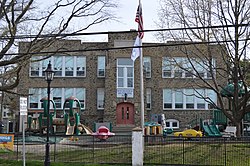
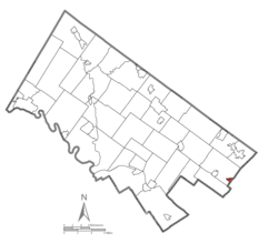
Rockledge is a borough in Montgomery County, Pennsylvania, United States. The population was 2,638 as of the 2020 census. Rockledge is surrounded by Abington Township and the city of Philadelphia, and shares a ZIP code with Jenkintown.
According to the United States Census Bureau, the borough has a total area of 0.3 square miles (0.78 km2), all land.
As of 2007 there were 7.31 miles (11.76 km) of public roads in Rockledge, of which 0.85 miles (1.37 km) were maintained by the Pennsylvania Department of Transportation (PennDOT) and 6.46 miles (10.40 km) were maintained by the borough. [3]
Pennsylvania Route 232 is the only numbered highway serving the town. It traverses the borough on a northwest-southeast alignment along Huntingdon Pike.
SEPTA provides City Bus service to Rockledge along Route 24, which runs between the Frankford Transportation Center in Northeast Philadelphia and Southampton, and Route 28, which runs between the Fern Rock Transportation Center in North Philadelphia and the Torresdale and Cottman Avenues Loop in Northeast Philadelphia. The Fox Chase station which serves as the terminus of SEPTA Regional Rail's Fox Chase Line is located near Rockledge in the Fox Chase neighborhood of Philadelphia. [4]
Census | Pop. | Note | %± |
---|---|---|---|
1900 | 512 | — | |
1910 | 879 | 71.7% | |
1920 | 1,029 | 17.1% | |
1930 | 1,920 | 86.6% | |
1940 | 1,773 | −7.7% | |
1950 | 2,261 | 27.5% | |
1960 | 2,587 | 14.4% | |
1970 | 2,564 | −0.9% | |
1980 | 2,538 | −1.0% | |
1990 | 2,679 | 5.6% | |
2000 | 2,577 | −3.8% | |
2010 | 2,543 | −1.3% | |
2020 | 2,638 | 3.7% | |
[5] |
As of the 2010 census, the borough was 95.8% White, 0.4% Black or African American, 1.2% Asian, and 2.0% were two or more races. 2.0% of the population were of Hispanic or Latino ancestry .
As of the census [6] of 2000, there were 2,577 people, 1,060 households, and 645 families residing in the borough. The population density was 7,428.9 inhabitants per square mile (2,868.3/km2). There were 1,091 housing units at an average density of 3,145.1 per square mile (1,214.3/km2). The racial makeup of the borough was 97.98% White, 0.04% African American, 0.04% Native American, 0.97% Asian, 0.31% from other races, and 0.66% from two or more races. Hispanic or Latino of any race were 0.58% of the population.
There were 1,060 households, out of which 28.5% had children under the age of 18 living with them, 50.3% were married couples living together, 7.7% had a female householder with no husband present, and 39.1% were non-families. 34.6% of all households were made up of individuals, and 12.5% had someone living alone who was 65 years of age or older. The average household size was 2.43 and the average family size was 3.24.
In the borough the population was spread out, with 23.6% under the age of 18, 7.6% from 18 to 24, 32.3% from 25 to 44, 21.0% from 45 to 64, and 15.5% who were 65 years of age or older. The median age was 38 years. For every 100 females there were 91.9 males. For every 100 females age 18 and over, there were 90.9 males.
The median income for a household in the borough was $47,958, and the median income for a family was $55,455. Males had a median income of $40,349 versus $32,100 for females. The per capita income for the borough was $21,232. About 1.8% of families and 3.0% of the population were below the Poverty threshold, including 0.7% of those under age 18 and 8.8% of those age 65 or over.
Rockledge has a borough manager form of government with a mayor and a seven-member borough council.
The borough is part of the Pennsylvania's 4th congressional district (represented by Rep. Madeleine Dean), the 172nd State House District (represented by Rep. Kevin J. Boyle) and the 4th State Senate District (represented by Sen. Art Haywood).
Year | Republican | Democratic |
---|---|---|
2020 | 49.4% 778 | 49.6%780 |
2016 | 46.0% 646 | 48.8%686 |
2012 | 48.0% 661 | 50.6%696 |
2008 | 48.5% 706 | 50.5%735 |
2004 | 47.3% 658 | 52.3%728 |
2000 | 49.1%601 | 47.0% 575 |
The Rockledge Model Railroad Museum, located on the corner of Montgomery & Sylvania Avenues, is home to the GATSME Lines Model RR Club and is housed in a historic textile mill building. The club was formerly located in Fort Washington, until 2014, when it relocated to its current location.
Leesport is a borough in Berks County, Pennsylvania, United States. The population was 1,954 at the 2020 census.
Churchville is a census-designated place (CDP) in Northampton Township, Bucks County, Pennsylvania, United States. The population was 5,348 at the 2020 census.
Upper Southampton Township is a township in Bucks County, Pennsylvania, United States. The population was 15,152 at the 2010 census.
Prospect Park is a borough in Delaware County, Pennsylvania, United States. The population was 6,454 at the 2010 census, down from 6,594 at the 2000 census. It originated as a bedroom community of Philadelphia. It is located within 10 miles (16 km) of Center City, Philadelphia, with convenient rail access.
Bridgeport is a borough in Montgomery County, Pennsylvania, United States, 18 mi (29 km) north of Philadelphia on the Schuylkill River. Former industries included paper, flour, cotton, woolen mills, steel works, and brickyards. Bridgeport is 6 mi (9.7 km) east of Valley Forge, Pennsylvania. In 1777, during the American Revolutionary War, General George Washington and the Continental Army passed through Bridgeport on their way to their winter encampment in Valley Forge. A total of 3,097 people lived in Bridgeport in 1900; 3,860 in 1910; and 5,904 in 1940. The population was 4,554 at the 2010 census.
Bryn Athyn is a home rule municipality in Montgomery County, Pennsylvania. It was formerly a borough, and its official name remains "Borough of Bryn Athyn". The population was 1,375 at the 2010 census. It was formed for religious reasons from Moreland Township on February 8, 1916. Bryn Athyn is surrounded by Lower Moreland Township.
Conshohocken is a borough on the Schuylkill River in Montgomery County, Pennsylvania in suburban Philadelphia. Historically a large mill town and industrial and manufacturing center, after the decline of industry in recent years Conshohocken has developed into a center of riverfront commercial and residential development. In the regional slang, it is sometimes referred to by the colloquial nickname Conshy.
Hatfield is a borough in Montgomery County, Pennsylvania, United States. The population was 3,290 at the time of the 2010 census. It is part of the North Penn Valley region that is centered around the borough of Lansdale. The borough is surrounded by Hatfield Township.
Hatfield Township is a township in Montgomery County, Pennsylvania, United States. The population was 17,249 at the 2010 census. It is part of the North Penn Valley region which is centered around the borough of Lansdale.
Jenkintown is a borough in Montgomery County, Pennsylvania. It is approximately 10 miles (16 km) north of Center City Philadelphia.
Lower Gwynedd Township is a township and equestrian community in Montgomery County, Pennsylvania, United States. The population was 11,405 at the 2010 census. The township comprises four villages: Gwynedd, Gwynedd Valley, Penllyn, and Spring House. The township is considered a haven for those seeking a country lifestyle, while still being in close proximity to nearby towns and Center City Philadelphia. While its postal address is in Ambler, Pennsylvania (19002), it is not associated with the Borough of Ambler.
Lower Moreland Township is a township in Montgomery County, Pennsylvania, United States. The population was 13,917 at the 2020 census.
Lower Providence Township is a township in Montgomery County, Pennsylvania, United States. The township is located approximately 17 miles northwest of Philadelphia. The population was 25,625 at the 2020 census.
Montgomeryville is a census-designated place (CDP) in Montgomery Township, Montgomery County, Pennsylvania, United States. The population was 12,624 at the 2010 census. According to a 2010 Forbes magazine/Yahoo.com survey, Montgomeryville ranks 5th in America's top 10 affordable suburbs. It is part of the North Penn Valley region that is centered on the borough of Lansdale.
Royersford is a borough in Montgomery County, Pennsylvania, United States, 32 miles (51 km) northwest of Philadelphia, on the Schuylkill River.
Trappe is a borough in Montgomery County, Pennsylvania, United States. The population was 3,509 at the 2010 census. Augustus Lutheran Church, built in 1743, is the oldest unchanged Lutheran church building in the United States in continuous use by the same congregation. It has been designated a National Historic Landmark.
Upper Gwynedd Township is a township in Montgomery County, Pennsylvania, United States. The population was 15,552 at the time of the 2010 census. North Wales Borough is surrounded by Upper Gwynedd Township on all sides, and many homes and businesses with North Wales addresses are actually in Upper Gwynedd. Many properties with Lansdale addresses are in Upper Gwynedd as well. It is part of the North Penn Valley region that is centered around the borough of Lansdale.
Upper Providence Township is a township in Montgomery County, Pennsylvania, United States. As of the 2010 census, the township population was 21,219.
West Conshohocken is a borough in Montgomery County, Pennsylvania, United States. The population was 1,320 at the 2010 census.
West Norriton Township is a township that is located in Montgomery County, Pennsylvania, United States. It is part of the Norristown Area School District.