West Cork is a tourist region and municipal district in County Cork, Ireland. As a municipal district, West Cork falls within the administrative area of Cork County Council, and includes the towns of Bantry, Castletownbere, Clonakilty, Dunmanway, Schull and Skibbereen, and the 'key villages' of Baltimore, Ballydehob, Courtmacsherry, Drimoleague, Durrus, Glengarriff, Leap, Rosscarbery, Timoleague and Union Hall.

Bantry is a town in the civil parish of Kilmocomoge in the barony of Bantry on the southwest coast of County Cork, Ireland. It lies in West Cork at the head of Bantry Bay, a deep-water gulf extending for 30 km (19 mi) to the west. The Beara Peninsula is to the northwest, with Sheep's Head peninsula to the southwest.

The British Iron Age is a conventional name used in the archaeology of Great Britain, referring to the prehistoric and protohistoric phases of the Iron Age culture of the main island and the smaller islands, typically excluding prehistoric Ireland, which had an independent Iron Age culture of its own. The Iron Age is not an archaeological horizon of common artefacts but is rather a locally-diverse cultural phase.

Beara or the Beara Peninsula is a peninsula on the south-west coast of Ireland, bounded between the Kenmare "river" to the north side and Bantry Bay to the south. It contains two mountain ranges running down its centre: the Caha Mountains and the Slieve Miskish Mountains. The northern part of the peninsula from Kenmare to near Ardgroom is in County Kerry, while the rest forms the barony of Bear in County Cork.
Durrus is a washed rind cow's milk cheese from Ireland. It was developed by Jeffa Gill in 1979, and is made by traditional methods. Durrus is produced in the valley of Coomkeen, near the village of Durrus on the Sheep's Head Peninsula in County Cork Ireland, where local herds provide the raw milk needed to make it.
Ahakista is located approximately halfway along the Sheep's Head peninsula between Durrus and Kilcrohane in County Cork, Ireland. It is a wooded coastal village with a deep and sheltered harbour.

Kilcrohane is a village in County Cork, Ireland. It is the last coastal village on the Sheep's Head Peninsula after Durrus and Ahakista. Kilcrohane lies under the 'Shadow of Seefin' and is also close to Caher Mountain. The village overlooks Dunmanus Bay. The village is in a townland and civil parish of the same name.

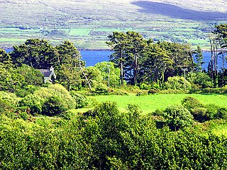
Durrus is a village and civil parish in West Cork in Ireland. It is situated ten kilometres (6 mi) from Bantry in County Cork, at the head of the Sheep's Head and the Mizen Head peninsulas.
The area surrounding Durrus village and civil parish has been inhabited since Neolithic times. The current layout of Durrus village, in West Cork in the south of Ireland, has its basis in developments during the 19th century.
The Munster pilchard fishery, from approximately 1570 to 1750, saw the fishing of pilchard (sardine) stocks along the South West coast of Ireland between Ardmore, County Waterford and Ballinskelligs, County Kerry. This was an important industry, with Baltimore, Dunmanus, Schull, Sherkin, Kinsale, Bantry, Whiddy Island as centres, together with outlying curing station called "Pallices" of which there were significant numbers along the Southern coast.

Dunmanus Bay is a bay in County Cork, Ireland. The bay lies between Mizen Head to the south and Sheep's Head to the north with the small village of Durrus at the head of the bay. The bay is out of the main tidal flow with no significant rivers flowing into it and is little frequented by vessels. On the eastern shore of the bay are the ruins of Dunmanus Castle built by the O'Mahony clan in 1430. To the south, Dunlough Castle, an earlier O'Mahony fortification, stands atop the cliffs at the northern perch of the Mizen peninsula.

The National Museum of Ireland – Archaeology is a branch of the National Museum of Ireland located on Kildare Street in Dublin, Ireland, that specialises in Irish and other antiquities dating from the Stone Age to the Late Middle Ages.

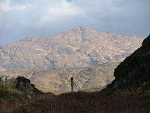
Caher Mountain is a hill, 338 metres high, with views of the Sheep's Head peninsula, roughly west of and above the village of Kilcrohane in County Cork, Ireland.

The Wild Atlantic Way is a tourism trail on the west coast, and on parts of the north and south coasts, of Ireland. The 2,500 km driving route passes through nine counties and three provinces, stretching from County Donegal's Inishowen Peninsula in Ulster to Kinsale, County Cork, in Munster, on the Celtic Sea coast.

The R591 road is a regional road in Ireland. It is a road on the Mizen Peninsula in County Cork. Most of the road forms part of the Wild Atlantic Way.
The Coolcoulaghta Standing Stones are a pair of standing stones forming a stone row and National Monument located in County Cork, Ireland.
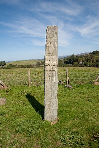
The Kilnaruane Pillar Stone is a carved monolith and National Monument located in County Cork, Ireland.
Breeny More Stone Circle is an axial stone circle and National Monument located in County Cork, Ireland.