Shire of Bundanba

Last updated

Map of Bundanba Division and adjacent local government areas, March 1902. Legend: Ipswich Municipality (2), Brassall Division (9), Bundanba Division (10), Normanby Division (13), Rosewood Division (14), Walloon (17) Bundanba Division, March 1902.jpg
Map of Bundanba Division and adjacent local government areas, March 1902. Legend: Ipswich Municipality (2), Brassall Division (9), Bundanba Division (10), Normanby Division (13), Rosewood Division (14), Walloon (17)

The Shire of Bundanba is a former local government area in the south-east of Queensland, Australia. It existed from 1879 to 1916.

Contents

The spelling of Bundanba was officially changed to Bundamba in 1932, but the Bundamba spelling was in common use long prior to that. [1]

History

On 11 November 1879, the Bundanba Division was created as one of 74 divisions within Queensland under the Divisional Boards Act 1879 with a population of 1828. [2] [3]

With the passage of the Local Authorities Act 1902, the Bundanba Division became the Shire of Bundanba on 31 March 1903. [3] [4]

The Greater Ipswich Scheme

On 13 October 1916, a rationalisation of the local government areas in and around Ipswich was implemented. It involved the abolition of five shires: [5]

resulting in:

Chairmen

Harry Ferrett, chairman of Bundanba Shire Council, 1912 Harry Ferrett, chairman of Bundanba Shire Council, 1912.JPG
Harry Ferrett, chairman of Bundanba Shire Council, 1912

The following served as chairmen:

Other notable councillors

Related Research Articles

<span class="mw-page-title-main">Shire of Boonah</span> Local government area in Queensland, Australia

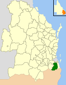
The Shire of Boonah was a local government area in South East Queensland, Australia, about 80 kilometres (50 mi) southwest of Brisbane. The shire covered an area of 1,921.6 square kilometres (741.9 sq mi), and existed from 1880 until its merger with parts of the Shire of Beaudesert and City of Ipswich to form the Scenic Rim Region on 15 March 2008.

<span class="mw-page-title-main">Beaudesert Shire</span> Local government area in Queensland, Australia

The Shire of Beaudesert was a local government area located in South East Queensland, Australia, stretching from the New South Wales border, along the Gold Coast hinterland to the urban fringes of the cities of Brisbane and Ipswich. The Shire covered an area of 2,854.3 square kilometres (1,102.1 sq mi), and existed from 1879 until its abolition on 15 March 2008, following which it was split between Logan City and the new Scenic Rim Region.

<span class="mw-page-title-main">City of Ipswich</span> Local government area in Queensland, Australia

The City of Ipswich is a local government area (LGA) located within the southwest of the Brisbane, which itself is situated within the vast South East region of Queensland, Australia. Positioned between the City of Brisbane and the City of Logan to the east and the Scenic Rim Region to the south, the city also borders the Somerset and Lockyer Valley regions to the north and west, respectively. Ipswich is generally taken to include the urban area encompassing the historical city of Ipswich and the surrounding rural areas. By the 2021 census, the City of Ipswich, as a local government area, had a population of 229,208 people.

<span class="mw-page-title-main">Bundamba, Queensland</span> Suburb of Ipswich, Queensland, Australia

Bundamba is a suburb of Ipswich in the City of Ipswich, Queensland, Australia. In the 2021 census, Bundamba had a population of 6,542 people.

<span class="mw-page-title-main">Silkstone, Queensland</span> Suburb of Ipswich, Queensland, Australia

Silkstone is a suburb in the City of Ipswich, Queensland, Australia. In the 2021 census, Silkstone had a population of 3,830 people.

<span class="mw-page-title-main">Brassall, Queensland</span> Suburb of Ipswich, Queensland, Australia

Brassall is a suburb in the City of Ipswich, Queensland, Australia. In the 2021 census, Brassall had a population of 12,115 people.

<span class="mw-page-title-main">Haigslea, Queensland</span> Suburb of Ipswich, Queensland, Australia

Haigslea is a locality split between the City of Ipswich and the Somerset Region in South East Queensland, Australia. In the 2021 census, Haigslea had a population of 507 people.

The Shire of Moreton was a local government area in South East Queensland, Australia, located about 50 kilometres (31 mi) southwest of Queensland's capital, Brisbane. It represented an area surrounding but not including Ipswich, and existed from 1917 until 1995, when it merged into the City of Ipswich, City of Brisbane, and Shire of Esk.

The Shire of Waterford is a former local government area in the south-east of Queensland, Australia, centred on the town of Waterford. It existed between 1879 and 1948.

<span class="mw-page-title-main">Town of Southport</span> Local government area of Queensland, Australia

The Town of Southport was a local government area in South East Queensland, Australia.

The Town of South Coast was a local government area in South East Queensland, Australia.

<span class="mw-page-title-main">Town of Laidley</span> Local government area of Queensland, Australia

The Town of Laidley is a former local government area comprising the town of Laidley in the Lockyer Valley area between the cities Ipswich and Toowoomba in Queensland, Australia. It existed between 1902 and 1917.

<span class="mw-page-title-main">Shire of Brassall</span> Local government area of Queensland, Australia

The Shire of Brassall is a former local government area in the south-east of Queensland, Australia. It existed from 1879 to 1917.

<span class="mw-page-title-main">Shire of Walloon</span> Local government area of Queensland, Australia

The Shire of Walloon is a former local government area in the south-east of Queensland, Australia. Its administrative centre was in the town of Marburg.

<span class="mw-page-title-main">Shire of Purga</span> Local government area in the south-east of Queensland, Australia

The Shire of Purga is a former local government area in the south-east of Queensland, Australia.

<span class="mw-page-title-main">Shire of Rosewood</span> Local government area of Queensland, Australia

The Shire of Rosewood is a former local government area in the south-east of Queensland, Australia.

The Shire of Lowood is a former local government area in the south-east of Queensland, Australia. It existed between 1912 and 1916.

The Shire of Ipswich is a former local government area in the south-east of Queensland, Australia.

<span class="mw-page-title-main">Shire of Mutdapilly</span> Local government area of Queensland, Australia

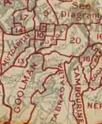
The Shire of Mutdapilly is a former local government area in the south-east of Queensland, Australia. The name comes from the Mutdapilly locality, but the locality was never the administrative centre of the shire.

<span class="mw-page-title-main">Shire of Normanby</span> Local government area of Queensland, Australia

The Shire of Normanby is a former local government area in the south-east of Queensland, Australia. Its administrative centre was in Harrisville.

References

  1. "Murmurs of the Shell". Queensland Figaro and Punch . Brisbane: National Library of Australia. 14 April 1888. p. 25 Supplement: THE LADY SUPPLEMENT TO QUEENSLAND FIGARO. Retrieved 12 September 2013.
  2. "Proclamation [Bundanba Division]". Queensland Government Gazette . 11 November 1879. p. 25:990.
  3. 1 2 "Agency ID 360, Bundamba Divisional Board". Queensland State Archives . Retrieved 12 September 2013.
  4. "Agency ID 361, Bundamba Shire Council". Queensland State Archives . Retrieved 12 September 2013.
  5. "Greater Ipswich Scheme". The Brisbane Courier . National Library of Australia. 14 October 1916. p. 4. Retrieved 12 September 2013.
  6. "Agency ID 992, Ipswich City Council". Queensland State Archives . Retrieved 12 September 2013.
  7. "Agency ID 995, Ipswich Shire Council". Queensland State Archives . Retrieved 12 September 2013.
  8. "Agency ID 11326, Lowood Shire Council". Queensland State Archives . Retrieved 12 September 2013.
  9. "Bundamba Road Names" (PDF). Ipswich City Council. Archived from the original (PDF) on 15 April 2012. Retrieved 27 February 2014.
  10. 1 2 "Booval Road Names" (PDF). Ipswich City Council. Archived from the original (PDF) on 7 April 2012. Retrieved 27 February 2014.
  11. 1 2 3 4 "Cr. H. Ferrett". The Queensland Times . National Library of Australia. 14 February 1912. p. 6 Edition: DAILY. Retrieved 27 February 2014.

27°36′30″S152°48′39″E / 27.6084°S 152.8107°E / -27.6084; 152.8107