Srinagar–Kargil–Leh line

Last updated

Srinagar–Kargil–Leh line
Overview
StatusProposed
Locale Srinagar, Jammu and Kashmir
Stations Srinagar (Start) to Leh(End)
Services SrinagarKargilLeh
Website http://www.indianrailways.gov.in
Operation
Operator(s) Indian Railways
Technical
Track gauge 1,676 mm (5 ft 6.0 in)

The Srinagar–Kargil–Leh line is a proposed railway line from Srinagar station via the town of Kargil to Leh by Indian Railways. The line was designated a national project on 26 February 2013

Srinagar City in Jammu and Kashmir, India

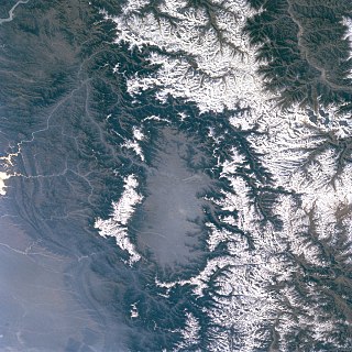
Srinagar is the largest city and the summer capital of the Indian state of Jammu and Kashmir. It lies in the Kashmir Valley on the banks of the Jhelum River, a tributary of the Indus, and Dal and Anchar lakes. The city is known for its natural environment, gardens, waterfronts and houseboats. It is also known for traditional Kashmiri handicrafts and dried fruits. It is the northernmost city of India with over 1 million people.

Kargil town in Jammu and Kashmir, India

Kargil is a town in the Kargil district of Ladakh region, in the Indian state of Jammu and Kashmir. It is the second largest town in Ladakh after Leh. It is located 60 km and 204 km from Drass and Srinagar to the west respectively, 234 km from Leh to the east, 240 km from Padum to the southeast and 1,047 km from Delhi to the south.

Leh City in Jammu and Kashmir, India

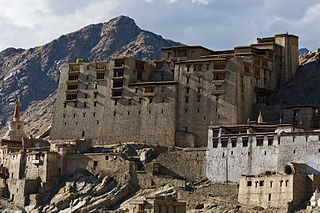
Leh is a town in the Leh district of the Indian state of Jammu and Kashmir. It was the capital of the Himalayan kingdom of Ladakh, the seat of which was in the Leh Palace, the former mansion of the royal family of Ladakh, built in the same style and about the same time as the Potala Palace in Tibet - the chief residence of the Dalai Lama until the 14th Dalai Lama fled to Dharamshala, India, during the 1959 Tibetan uprising. Leh is at an altitude of 3,524 metres (11,562 ft), and is connected via National Highway 1 to Srinagar in the southwest and to Manali in the south via the Leh-Manali Highway. In 2010, Leh was heavily damaged by the sudden floods caused by a cloud burst.

Contents

The railway minister of India, Pawan Kumar Bansal announced that the survey of Srinagar Kargil Leh line will be undertaken during the year 2013-14. [1]

Pawan Kumar Bansal Indian National Congress politician

Pawan Kumar Bansal is an Indian National Congress politician and a former minister in the Manmohan Singh government. He represented Chandigarh constituency in the 15th Lok Sabha of India. He served as Minister of Railways from 28 October 2012 to 10 May 2013.

Strategic importance

Once this railway line is completed, Leh will be directly connected to Jammu and Kashmir and the rest of India by railway. The distance between Srinagar and Leh by road is about 422 km (262 mi). When the railway lines to Leh is completed, the time taken to reach Leh from Delhi will be reduced. It will provide safe and quick mode of public transport. Personnel and equipment will be transported more easily to Leh, a strategic military base.

Jammu and Kashmir State in India

Jammu and Kashmir is a state in northern India, often denoted by its acronym, J&K. It is located mostly in the Himalayan mountains, and shares borders with the states of Himachal Pradesh and Punjab to the south. The Line of Control separates it from the Pakistani-administered territories of Azad Kashmir and Gilgit-Baltistan in the west and north respectively, and a Line of Actual Control separates it from the Chinese-administered territory of Aksai Chin in the east. The state has special autonomy under Article 370 of the Constitution of India.

Challenges

After the Jammu–Baramulla line, the Srinagar–Kargil–Leh line will be the most challenging railway project in Indian Railways due to high mountains, a large number of tunnels and high bridges and severe cold weather.

Jammu–Baramulla line

The Jammu–Srinagar-Baramulla railway line is a railway track being laid to connect the Kashmir Valley in the Indian state of Jammu and Kashmir with Jammu railway station and thence to the rest of the country. The 356 km railway track begins at Jammu and ends at Baramulla. It is in the jurisdiction of the Firozpur railway division of Indian Railways' Northern zone.

Indian Railways Indian state-owned enterprise, owned and operated by the Government of India

Indian Railways (IR) is India's national railway system operated by the Ministry of Railways. It manages the fourth-largest railway network in the world by size, with 121,407 kilometres (75,439 mi) of total track over a 67,368-kilometre (41,861 mi) route. Forty nine percent of the routes are electrified with 25 KV AC electric traction while thirty three percent of them are double or multi-tracked.

See also

The Jalandhar–Jammu line is a railway line connecting Jalandhar Cantonment / Jalandhar City in the Indian state of Punjab and Jammu Tawi in Jammu & Kashmir. The line is under the administrative jurisdiction of Northern Railway.

The Jammu–Poonch line is a proposed railway line from Jammu Tawi station via the Historic City of Akhnoor to Poonch via Kaleeth-Dori Dager-Chowki Choura-Bhambla-Nowshera-Rajouri. The line was designated a national project on 22 March 2012.

Bilaspur(Himachal Pradesh) –Manali–Leh line is a proposed high-elevation all-weather 1,676 mm broad gauge railway track that is planned to connect Bilaspur in Himachal Pradesh to Leh in Ladakh region of Jammu and Kashmir state of India. It would link to the Indian railway network via an extension of the Kangra Valley Railway to Mandi, which would be converted to 1,676 mm broad gauge.

Related Research Articles

Kargil district District of Jammu and Kashmir in India

The Kargil district is a district of Ladakh division in the Indian state of Jammu and Kashmir. It spans the entire length of the state in the north-south direction, with the Pakistan-administered region of Gilgit–Baltistan to the north, the Kashmir and Jammu divisions to the west, and the Leh district of the Ladakh division to the east. Zanskar is part of Kargil district along with Suru, Wakha and Dras valleys.

Kashmir Valley Place in Jammu and Kashmir, India

The Kashmir Valley, also known as the Vale of Kashmir, is a valley in the portion of the Kashmir region administered by India. The valley is bounded on the southwest by the Pir Panjal Range and on the northeast by the main Himalayas range. It is approximately 135 km long and 32 km wide, and drained by the Jhelum River.

Mountain railways of India Mountain railways in India that are UNESCO World Heritage Site

The mountain railways of India are the railway lines that were built in the mountains of India. Three of them, the Darjeeling Himalayan Railway, the Nilgiri Mountain Railway, and the Kalka–Shimla Railway, are collectively designated as a UNESCO World Heritage Site under the name Mountain Railways of India. The fourth railway, the Matheran Hill Railway, is on the tentative list of UNESCO World Heritage Sites. All four are narrow-gauge railways, and the Nilgiri Mountain Railway is also the only rack railway in India.

Baramulla City in Jammu and Kashmir, India

Baramulla (ˌbærəˈmʊlə) is a city and a municipality in the Baramulla district in the state of Jammu and Kashmir (India). It is on the bank of the Jhelum River downstream from Srinagar, the state capital. The city was earlier known as Varahamula which is Sanskrit for "boar's molar".

Tourism in Ladakh

Ladakh, a word which means "land of high passes", is a region in the state of Jammu and Kashmir of Northern India sandwiched between the Karakoram mountain range to the north and the Himalayas to the south and is situated at the height of 11,400 ft. The Indian portion of Ladakh is composed of the Leh and Kargil districts. The Leh district is the second largest district of India, covering more than half the area of Jammu and Kashmir, of which it is the eastern part.

Tourism in Jammu and Kashmir

Jammu and Kashmir is the northernmost state of India locked in Himalayan Mountains. Jammu and Kashmir is home to several Valleys such as the Kashmir Valley, Tawi, Chenab Valley, Poonch, Sindh Valley and Lidder Valley. Some major tourist attractions in Jammu and Kashmir are Srinagar, the Mughal Gardens, Gulmarg, Pahalgam, Patnitop, Jammu, and Ladakh. Some areas require a special permit for non-Indians to visit.

National Highway 1D (India, old numbering) old numbering of road in India

National Highway 1D, also known as Srinagar-Leh Highway, was a National Highway entirely within the state of Jammu & Kashmir in North India that connected Srinagar to Leh in Ladakh. It was one of the only two roads that connected Ladakh with the rest of India, the other being Leh-Manali Highway. The Srinagar-Leh Highway was declared as National Highway in 2006.

Pir Panjal Railway Tunnel Railway tunnel in India

The Pir Panjal Railway Tunnel or Banihal railway tunnel is an 11.215 km railway tunnel located in Pir Panjal Range of middle Himalayas in Jammu and Kashmir, India, north of Banihal town. It is a part of the Jammu–Baramulla line.

Srinagar railway station

Srinagar railway station or Nowgam railway station is a railway station of the city of Srinagar in the Indian state of Jammu and Kashmir.

The Sangaldan Railway Tunnel is a 7.1 km railway tunnel between Katra-Banihal section of Jammu–Baramulla line located to the north of Sangaldan town of middle Himalayas in Jammu and Kashmir, India near Ramban district. The tunnel was completed on 4 December 2010.

Shri Mata Vaishno Devi Katra railway station

Shri Mata Vaishno Devi Katra railway station is a train station on the Jammu Udhampur Srinagar Baramulla Railway Link in the Indian state of Jammu and Kashmir. It belongs to the Firozpur Division of Northern Railway zone in Jammu and Kashmir. It serves Katra town and the Sri Mata Vaishno Devi Temple.

Anantnag railway station

Anantnag railway station is a railway station on the Northern railway network. It is the headquarters of Anantnag division of Northern Railway zone.

Sadura Railway Station is a railway station on the Northern railway network of India. It is the headquarters of Anantnag division of Northern Railway zone.

National Highway 1 (India) national highway in India

National Highway 1 is a national highway in the Indian state of Jammu & Kashmir. NH 1 comprises parts of old NH1A and NH1D. The number 1 indicates, under the new numbering system, that it is the northernmost East-West highway in India.

References

  1. "Archived copy". Archived from the original on 16 July 2013. Retrieved 13 May 2013.CS1 maint: Archived copy as title (link)