Strathmore, New Jersey

Last updated

Strathmore, New Jersey
Strathmore, NJ.jpg
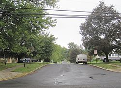
Looking along Ivy Way in Strathmore
Monmouth County New Jersey Incorporated and Unincorporated areas Strathmore Highlighted.svg
Map of Strathmore highlighted within Monmouth County. Right: Location of Monmouth County in New Jersey.
Location map of Monmouth County, New Jersey.svg
Red pog.svg
Strathmore
Location in Monmouth County
USA New Jersey relief location map.svg
Red pog.svg
Strathmore
Location in New Jersey
Usa edcp relief location map.png
Red pog.svg
Strathmore
Location in the United States
Coordinates: 40°24′06″N74°13′10″W / 40.401587°N 74.219349°W / 40.401587; -74.219349
Country Flag of the United States.svg  United States
State Flag of New Jersey.svg  New Jersey
County Monmouth
Township Aberdeen
Area
[1]
  Total2.02 sq mi (5.23 km2)
  Land1.97 sq mi (5.10 km2)
  Water0.05 sq mi (0.13 km2)  2.47%
Elevation
[2]
49 ft (15 m)
Population
 (2020) [3]
  Total7,225
  Density3,669.38/sq mi (1,417.11/km2)
Time zone UTC−05:00 (Eastern (EST))
  Summer (DST) UTC−04:00 (Eastern (EDT))
ZIP Code
07747 (Matawan) [4]
Area code(s) 732/848
FIPS code 34-71280 [5] [6] [7]
GNIS feature ID02390366 [5] [8]

Strathmore is an unincorporated community and census-designated place (CDP) within Aberdeen Township, in Monmouth County, New Jersey, United States. [9] [10] At the 2020 census, the CDP's population was 7,225. [3]

Contents

Strathmore was built starting in the early 1960s by Levitt & Sons, marketed as a higher-end version of the Levittown communities that the firm was known for. [11] [12] The 2,000 new homes in the development led to a jump in the township's population of 10,000 over the decade, a jump of more than 140%. [13] [14]

Geography

Strathmore is in northern Monmouth County and occupies most of the southeastern part of the township. It is bordered to the west by the borough of Matawan, to the east by Hazlet Township and Holmdel Township, and to the south by Marlboro Township. New Jersey Route 34 runs through the southwest side of the community, leading northwest into Matawan and south-southeast 3 miles (5 km) to Holmdel.

According to the United States Census Bureau, the Strathmore CDP has a total area of 2.019 square miles (5.23 km2), including 1.969 square miles (5.10 km2) of land and 0.050 square miles (0.13 km2) of water (2.48%). [1]

Demographics

Historical population
CensusPop.Note
1990 7,060
2000 6,740−4.5%
2010 7,2587.7%
2020 7,225−0.5%
Population sources:
1990-2010 [9] 2000 [15] 2010 [16] [3]

2010 census

The 2010 United States census counted 7,258 people, 2,557 households, and 2,089 families in the CDP. The population density was 3,682.0 people per square mile (1,421.6 people/km2). There were 2,607 housing units at an average density of 1,322.6 units per square mile (510.7 units/km2). The racial makeup was 86.68% (6,291) White, 3.94% (286) Black or African American, 0.10% (7) Native American, 6.63% (481) Asian, 0.03% (2) Pacific Islander, 1.25% (91) from other races, and 1.38% (100) from two or more races. Hispanic or Latino of any race were 6.85% (497) of the population. [16]

Of the 2,557 households, 38.1% had children under the age of 18; 71.4% were married couples living together; 7.5% had a female householder with no husband present and 18.3% were non-families. Of all households, 15.0% were made up of individuals and 6.6% had someone living alone who was 65 years of age or older. The average household size was 2.83 and the average family size was 3.16. [16]

25.0% of the population were under the age of 18, 5.7% from 18 to 24, 24.8% from 25 to 44, 31.4% from 45 to 64, and 13.0% who were 65 years of age or older. The median age was 41.7 years. For every 100 females, the population had 95.1 males. For every 100 females ages 18 and older there were 93.1 males. [16]

2000 census

At the 2000 census [6] there were 6,740 people, 2,348 households, and 2,031 families living in the CDP. The population density was 1,414.3 people/km2 (3,663 people/sq mi). There were 2,360 housing units at an average density of 495.2 units/km2 (1,283 units/sq mi). The racial makeup of the CDP was 87.79% White, 3.29% African American, 0.06% Native American, 6.50% Asian, 0.64% from other races, and 1.72% from two or more races. Hispanic or Latino of any race were 4.67% of the population. [15]

Of the 2,348 households 38.9% had children under the age of 18 living with them, 76.8% were married couples living together, 7.5% had a female householder with no husband present, and 13.5% were non-families. 11.2% of households were one person and 4.5% were one person aged 65 or older. The average household size was 2.87 and the average family size was 3.11. [15]

The age distribution was 25.1% under the age of 18, 5.1% from 18 to 24, 31.0% from 25 to 44, 27.1% from 45 to 64, and 11.6% 65 or older. The median age was 39 years. For every 100 females, there were 94.6 males. For every 100 females age 18 and over, there were 93.4 males. [15]

The median household income was $85,890 and the median family income was $90,655. Males had a median income of $61,971 versus $39,559 for females. The per capita income for the CDP was $32,984. About 2.0% of families and 2.3% of the population were below the poverty line, including 3.8% of those under age 18 and 0.6% of those age 65 or over. [15]

Transportation

New Jersey Transit provides bus transportation to the Port Authority Bus Terminal in Midtown Manhattan on the 133 route. [17]

Related Research Articles

<span class="mw-page-title-main">Brownville, New Jersey</span> Populated place in Middlesex County, New Jersey, US

Brownville is an unincorporated community and census-designated place (CDP) in Old Bridge Township, Middlesex County, New Jersey, United States. As of the 2020 census, the population was 2,746, up from 2,383 in 2010.

<span class="mw-page-title-main">Monmouth Junction, New Jersey</span> Populated place in Middlesex County, New Jersey, US

Monmouth Junction is an unincorporated community and census designated place (CDP) in South Brunswick Township, Middlesex County, New Jersey, United States. As of the 2020 census, the CDP's population was 8,895, up 208% from its population of 2,887 in 2010.

<span class="mw-page-title-main">Old Bridge (CDP), New Jersey</span> Populated place in Middlesex County, New Jersey, US

Old Bridge is a census-designated place (CDP) in Old Bridge Township, Middlesex County, New Jersey, United States. As of the 2020 census, the CDP's population was 27,210, up from 23,753 in 2010. The Old Bridge CDP occupies only a portion of Old Bridge Township.

<span class="mw-page-title-main">Aberdeen Township, New Jersey</span> Township in Monmouth County, New Jersey, US

Aberdeen Township is a township situated on the Jersey Shore in Monmouth County, in the U.S. state of New Jersey. The township is located within the Raritan Valley region and is a part of the New York Metropolitan Area, bordering both Old Bridge Township, New Jersey, in adjacent Middlesex County, New Jersey, as well as Staten Island in New York City. As of the 2020 United States census, the township's population was 19,329, its highest decennial count ever and an increase of 1,119 (+6.1%) from the 2010 census count of 18,210, which had in turn reflected an increase of 756 (+4.3%) from the 17,454 recorded at the 2000 census.

<span class="mw-page-title-main">Cliffwood Beach, New Jersey</span> Populated place in Monmouth County, New Jersey, US

Cliffwood Beach is an unincorporated community and census-designated place (CDP) in Aberdeen Township, Monmouth County, New Jersey, United States. As of the 2020 census, the population was 3,036.

<span class="mw-page-title-main">East Freehold, New Jersey</span> Populated place in Monmouth County, New Jersey, US

East Freehold is an unincorporated community and census-designated place (CDP) in Freehold Township, Monmouth County, New Jersey, United States. As of the 2020 census, the CDP population was 4,987.

<span class="mw-page-title-main">Fairview, Monmouth County, New Jersey</span> Populated place in Monmouth County, New Jersey, US

Fairview is an unincorporated community and census-designated place (CDP) in Middletown Township, Monmouth County, New Jersey, United States. As of the 2020 United States census, the CDP's population was 3,731.

<span class="mw-page-title-main">Lincroft, New Jersey</span> Populated place in Monmouth County, New Jersey, US

Lincroft is an unincorporated community and census-designated place (CDP) in Middletown Township, Monmouth County, New Jersey, United States. As of the 2020 United States census, the CDP had a population of 7,060, reflecting a 15.1% increase from the 6,135 residents enumerated at the 2010 U.S. Census, in turn a decline of 120 residents (-1.9%) from the 6,255 counted in the 2000 U.S. Census.

<span class="mw-page-title-main">Morganville, New Jersey</span> Populated place in Monmouth County, New Jersey, US

Morganville is an unincorporated community and census-designated place (CDP) within Marlboro Township, in Monmouth County, New Jersey, United States. As of the 2020 census, the CDP's population was 6,203, up from 5,040 in 2010.

<span class="mw-page-title-main">North Middletown, New Jersey</span> Populated place in Monmouth County, New Jersey, US

North Middletown is an unincorporated community and census-designated place (CDP) within Middletown Township, in Monmouth County, in the U.S. state of New Jersey. As of the 2020 census, the CDP population was 3,146, down from 3,295 in 2010.

<span class="mw-page-title-main">Oakhurst, New Jersey</span> Place in Monmouth County, New Jersey, United States

Oakhurst is an unincorporated community and census-designated place (CDP) in Ocean Township, Monmouth County, New Jersey, United States. As of the 2020 census, the CDP population was 4,069.

<span class="mw-page-title-main">Port Monmouth, New Jersey</span> Populated place in Monmouth County, New Jersey, US

Port Monmouth is an unincorporated community and census-designated place (CDP) in Middletown Township, situated on the Raritan Bayshore of northern Monmouth County, New Jersey, United States. At the 2020 United States census, the CDP's population was 3,745, a decrease of 73 (−1.9%) from the 2010 census count of 3,818.

<span class="mw-page-title-main">Shark River Hills, New Jersey</span> Populated place in Monmouth County, New Jersey, US

Shark River Hills is an unincorporated community and census-designated place (CDP) within Neptune Township, in Monmouth County, New Jersey, United States. As of the 2020 census, the CDP's population was 3,583.

<span class="mw-page-title-main">Wanamassa, New Jersey</span> Populated place in Monmouth County, New Jersey, US

Wanamassa is an unincorporated community and census-designated place (CDP) within Ocean Township, in Monmouth County, New Jersey, United States. As of the 2020 census, the CDP's population was 4,344. The community was named for Wanamassa, a Native American leader of the 17th century.

<span class="mw-page-title-main">West Belmar, New Jersey</span> Populated place in Monmouth County, New Jersey, US

West Belmar is an unincorporated community and census-designated place (CDP) within Wall Township, in Monmouth County, in the U.S. state of New Jersey. As of the 2020 census, the CDP's population was 2,459.

<span class="mw-page-title-main">Allenwood, New Jersey</span> Populated place in Monmouth County, New Jersey, US

Allenwood is an unincorporated community and census-designated place (CDP) in Wall Township, Monmouth County, New Jersey, United States. As of the 2020 United States census, the CDP's population was 954.

<span class="mw-page-title-main">Belford, New Jersey</span> Populated place in Monmouth County, New Jersey, US

Belford is an unincorporated community and census-designated place (CDP) in Middletown Township, Monmouth County, New Jersey, United States. As of the 2020 census, the CDP's population was 1,648.

<span class="mw-page-title-main">Yorketown, New Jersey</span> Populated place in Monmouth County, New Jersey, US

Yorketown is an unincorporated community and census-designated place (CDP) within Manalapan Township, in Monmouth County, in the U.S. state of New Jersey. As of the 2020 census, the CDP's population was 6,617.

<span class="mw-page-title-main">Ramtown, New Jersey</span> Populated place in Monmouth County, New Jersey, US

Ramtown is a census-designated place and unincorporated community in Howell Township, in Monmouth County, New Jersey, United States. As of the 2020 United States census, the CDP population was 6,329.

<span class="mw-page-title-main">Robertsville, New Jersey</span> Populated place in Monmouth County, New Jersey, US

Robertsville is a census-designated place and unincorporated community in Marlboro Township, Monmouth County, in the U.S. state of New Jersey. As of the 2020 census, the CDP's population was 11,399.

References

  1. 1 2 "2024 U.S. Gazetteer Files: New Jersey". United States Census Bureau. Retrieved September 25, 2024.
  2. U.S. Geological Survey Geographic Names Information System: Strathmore Census Designated Place, Geographic Names Information System. Accessed August 4, 2012.
  3. 1 2 3 "Census Population API". United States Census Bureau. Retrieved October 11, 2022.
  4. Look Up a ZIP Code for Strathmore, NJ, United States Postal Service. Accessed August 5, 2012.
  5. 1 2 Gazetteer of New Jersey Places, United States Census Bureau. Accessed July 21, 2016.
  6. 1 2 U.S. Census website, United States Census Bureau. Accessed September 4, 2014.
  7. Geographic Codes Lookup for New Jersey, Missouri Census Data Center. Accessed June 9, 2023.
  8. US Board on Geographic Names, United States Geological Survey. Accessed September 4, 2014.
  9. 1 2 New Jersey: 2010 - Population and Housing Unit Counts - 2010 Census of Population and Housing (CPH-2-32), United States Census Bureau, August 2012. Accessed December 14, 2012.
  10. GCT-PH1 - Population, Housing Units, Area, and Density: 2010 - County County Subdivision and Place from the 2010 Census Summary File 1 for Monmouth County, New Jersey Archived 2020-02-12 at archive.today , United States Census Bureau. Accessed December 14, 2012.
  11. Murray, Ed; and Strunsky, Steve. "This pool club was stuck in the '60s. Now, it's a posh modern retreat in suburbia", NJ Advance Media for NJ.com, September 25, 2018. Accessed October 9, 2024. "The community originally known as Strathmore at Matawan was developed starting in 1961 by Levitt & Sons, the firm best known for its much larger Levittown community on Long Island, developed beginning in 1947 largely to provide low-cost housing for the young families of veterans returning from World War II. Unlike the unabashedly working-class nature of Levittown, Strathmore was more aspirational, taking its name from Levitt's more upscale, Strathmore subdivisions built before the war."
  12. Strathmore at Matawan, New Jersey, LevittownBeyond.com. Accessed October 9, 2024.
  13. Evans, Scott. "Levitt was no homebody", PhillyBurbs.com, June 24, 2012. Accessed October 9, 2024. "Strathmore, N.J. Originally known as Strathmore-at-Matawan, the approximately 2,000 houses that Levitt erected, beginning in 1964, more than doubled the population of what was then called Matawan Township. In 1977, voters changed the municipality’s name to Aberdeen."
  14. Table 6: New Jersey Resident Population by Municipality: 1940 - 2000, Workforce New Jersey Public Information Network, August 2001. Accessed October 9, 2024.
  15. 1 2 3 4 5 DP-1 - Profile of General Demographic Characteristics: 2000 from the Census 2000 Summary File 1 (SF 1) 100-Percent Data for Strathmore CDP, New Jersey Archived 2020-02-12 at archive.today , United States Census Bureau. Accessed December 14, 2012.
  16. 1 2 3 4 DP-1 - Profile of General Population and Housing Characteristics: 2010 Demographic Profile Data for Strathmore CDP, Monmouth County, New Jersey, United States Census Bureau. Accessed August 5, 2012.
  17. Monmouth County Bus / Rail connections, New Jersey Transit, backed up by the Internet Archive as of July 26, 2010. Accessed August 5, 2012.