Sursum Corda (Washington, D.C.)

Last updated
Map of Washington, D.C., with Sursum Corda highlighted in red Map sursum corda.jpg
Map of Washington, D.C., with Sursum Corda highlighted in red

Sursum Corda (Latin: "lift up your hearts") is a small neighborhood located in Washington, D.C., bounded by North Capitol Street on the east, K Street NW to the south, New Jersey Avenue NW to the west, and New York Avenue NW to the north. [1]

Contents

The neighborhood draws its name for the Sursum Corda Co-operative Apartments, a 199-unit low-income housing complex constructed in 1968. The area became a notorious open-air drug market plagued by violence and poverty in the 1980s. After a notorious 2004 murder in the neighborhood, demolition and complete renovation of the low-income housing in Sursum Corda was announced in 2007. Little of the redevelopment happened, although extensive demolition occurred.[ citation needed ]

History

Residential neighborhoods north of Massachusetts Avenue underwent a prolonged decay in the first half of the 20th century. Controversial urban renewal plans of the 1950s and 1960s called for massive demolition of the area, part of it comprising the old Irish American neighborhood of Swampoodle. The plans though were only partially executed.[ citation needed ]

Sursum Corda Co-operative

Various Masonic and religious organizations took advantage of loan programs of the recently created U.S. Department of Housing and Urban Development (HUD) to build housing for some of the displaced households. A group of Catholic activists from the nearby Gonzaga College High School and the parish of St. Aloysius conceived of a new urban village to house some of the households displaced by the demolitions. They also received support from the D.C. Public Housing Authority and the then-Senator from New York, Robert F. Kennedy.

The leading organizer and founder of the Cooperative was Eugene L. Stewart, an alumnus of Georgetown University. [2] [3] In 1965, Stewart was approached as a member of the Georgetown Alumni Association and asked if the Association would become involved by sponsoring a low income housing project. [4] [5] The idea presented to him was for students and alumni to assist with tutoring the poor and their children in the community. Stewart presented the ideas to the Alumni Board of Governors, but the plan was rejected. He formed Sursum Corda, Inc. and oversaw the construction of the Sursum Corda Cooperative. [5]

Image of Sursum Corda Cooperative on 1st Street NW, taken in January 2014. Sursum Corda Flickr.jpg
Image of Sursum Corda Cooperative on 1st Street NW, taken in January 2014.

Construction on the new development began in 1967. It was named Sursum Corda, a Latin expression meaning "Lift up your hearts" (which is intoned at the start of the Eucharistic Prayer during the Mass). The original plan called for 155 resident-owned and 44 rental townhouses on four acres (16,000 m2), arranged on courtyards and alleys around a horseshoe-shaped street (1st Terrace, L Place, and 1st Place NW) to promote a sense of community. The style was quite unusual for public housing of the era, in that the neighborhood was largely closed off, presaging some of the HOPE VI rehabilitation plans. The units offered amenities such as air conditioning, washer and dryer units, and kitchen garbage disposals. Rents were originally fixed at 25 percent of the residents' income.[ citation needed ]

A group of nuns from the religious institute of the Religious of the Sacred Heart (R.S.C.J.) were among the first residents, aiming to support and minister to the new residents. Father Horace McKenna, a Jesuit priest at St. Aloysius Church at Gonzaga College High School and well-known advocate for the poor, established a program to bring Georgetown University undergraduate students to tutor children in the neighborhood, a program which continues to the present day. McKenna Walk NW is named for him.[ citation needed ]

Disadvantageous tax laws led to neglect of the properties, and the arrival of crack cocaine in the 1980s sent the neighborhood into a steep decline. Its layout made it difficult to police, and consequently an ideal drug market and frequent battleground for street gangs. Despite the efforts of the Tenants Association, it became associated with poverty and crime. Even the nuns were driven away, the last departing in the early 1990s.[ citation needed ]

Other community landmarks

The Sursum Corda neighborhood also contains the Julius Hobson Plaza Condominiums (named for Julius Hobson, a civil rights activist and member of the first elected Council of the District of Columbia), the Severna Apartments, Sibley Plaza, the Turnkey, and the Tyler House Apartments. Sibley Plaza and the Turnkey are both owned by the District of Columbia Housing Authority (DCHA), while the DeSeverna and Tyler House Apartments contain large numbers of units subsidized by the DCHA. [6]

Local landmarks include the Walker-Jones Education Campus (preschool through eighth-grade) on New Jersey Avenue NW between Pierce and L Streets NW and its associated athletic field and basketball courts; the K Street Farm (a 1-acre (4,000 m2) good farm managed by Walker-Jones teachers) on the northwest corner of K Street NW and New Jersey Avenue NW; [7] and the Northwest One Neighborhood Library (built in 2009). [8]

Neighborhood redevelopment

On January 23, 2004, 14-year-old Jahkema "Princess" Hansen was murdered in the Sursum Corda Co-operative. Hansen was involved with 28-year-old Marquette Ward, a known drug dealer. [9] On January 18, 2004, Ward shot and killed 21-year-old Mario J. Evans in a hallway at the Temple Court Apartments for refusing to sell him a discounted drug. [10] Hansen and an 18-year-old girl witnessed the murder. Ward, worried that Hansen would talk to the police, paid 22-year-old Franklin Thompson $8,000 to kill Hansen. While Hansen ate dinner at a friend's apartment in the Sursum Corda Co-op on January 23, Thompson burst into the apartment and opened fire, wounding a 12-year-old girl. Hansen fled through the apartment. Thompson chased her and shot her twice in the head. Thompson and Ward were both convicted of first-degree murder in 2006. [9]

Hansen's murder, which The Washington Post called "heinous" and "execution-style", shocked many residents of the city and drew attention to the terrible housing conditions and severe crime occurring in the neighborhood. [1] It also prodded city officials to spur redevelopment in the area. [1] [11]

Northwest One project

Determined to change the Sursum Corda neighborhood, the government of the District of Columbia announced a plan to tear down the Sursum Corda Co-op, the Golden Rule housing and retail complex, the Temple Court Apartments, [lower-alpha 1] and other nearby buildings and construct a $700 million mixed use housing, office, and retail center for low-income residents. The city said that William C. Smith & Co., Jair Lynch Partners, Banneker Ventures, and Community Preservation Development would lead the project. Dubbed Northwest One, the project would build 1,630 units (spread among apartments, condominiums, and townhouses), rebuild 40,000 square feet (3,700 m2) of retail space, add 220,000 square feet (20,000 m2) of office space, and construct a 21,000 square feet (2,000 m2) health clinic (to be run by Unity Health Clinic). Northwest One would triple the residential density of the area, and increase low-income housing to 571 units from 410 units. An additional $45 million in city funds would be used to rebuild Walker-Jones Elementary School and construct a new branch library in the area. [8]

Little actual redevelopment occurred, although most of the buildings were demolished. The Sursum Corda co-operative declined to participate in the redevelopment. But the owners of other structures, such as the Golden Rule complex (owned by Bible Way Temple, a nearby church) did. [1] Temple Court Apartments was the largest housing complex in the area, with 520 units. But the Bush Companies, which owned Temple Court, wanted to back out of the federal and city government-subsidized low-income housing plans and wanted to convert its units to market-rate housing. The District of Columbia exercised eminent domain over Temple Court, seizing it and ensuring it would not block the Northwest One plan. [11] Demolition of the participating structures occurred in 2008, with residents dispersed to other public housing projects in the city. [1] [lower-alpha 2] In 2009, the redeveloped Walker-Jones Education Campus and the Northwest One Neighborhood Library opened. But then redevelopment stopped. DCHA never assigned anyone to oversee the project, which left no one to push the developers to fulfill their agreement. DCHA itself was required to move from its headquarters at 1133 North Capitol Street NE to vacate and demolish its own headquarters to make way for the planned new housing, but the agency never did so. DCHA then lost the blueprints for the project, and only relocated them in June 2013. DCHA then discovered—after it had demolished the building—that the Temple Court Apartments were built with a mortgage insured by the United States Department of Housing and Urban Development. This $3.9 million insurance policy required that only subsidized housing could be built on the Temple Court land, but the Northwest One project envisioned market-rate, office, and retail use there. Mayor Adrian Fenty and Mayor Vincent C. Gray both pledged to resolve the issue, but never did. Only two of the many planned Northwest One buildings were constructed. One was the 2M Street Apartments at 2 M Street NE. Built with $16.8 million in DCHA funds, only 93 of its 314 units are subsidized for low-income residents. [1] The other was the Severna Apartments, owned and built by Bible Way Temple. [11] The $15.7 million building (constructed with $1.9 million in DCHA funds) opened in 2011. All of its units are for low-income residents. [1]

The construction of the nearby NoMa - Gallaudet University Metro station and a surge in property values sparked redevelopment of the area.

New Sursum Corda project

In August 2015, Sursum Corda Cooperative Association announced it had partnered with Winn Development Co. and adjacent private landowners in the neighborhood to redevelop the Sursum Corda co-op and the surrounding 6.7 acres (27,000 m2) of land into a new high-density, mixed use housing development. The development, which will occur in two phases, will contain more than 1,100 apartments, six times the co-op's current capacity. Five buildings, with 1,280,000 square feet (119,000 m2) of residential space, 41,000 square feet (3,800 m2) of retail space, and 800 parking spaces, will be constructed on two parcels. The first phase, constructed on the parcel at L and 1st Streets NE, will contain three buildings of 164 units, 166 units, and 100 units. The second phase, located at the site of the current Sursum Corda Co-operative Apartments, will see two buildings of 339 units and 373 units. [6]

Starting in November 2018, Toll Brothers development began demolition paving the way for the re-development. [12]

Related Research Articles

<span class="mw-page-title-main">Mount Pleasant (Washington, D.C.)</span> Neighborhood of Washington, D.C.

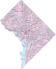
Mount Pleasant is a neighborhood in Washington, D.C., located in Northwest D.C. The neighborhood is primarily residential, with restaurants and stores centered along a commercial corridor on Mt. Pleasant Street. Mount Pleasant is known for its unique identity and multicultural landscape, home to diverse groups such as the punk rock, the Peace Corps and Hispanic Washingtonian communities.

<span class="mw-page-title-main">West End (Washington, D.C.)</span> Place in the United States

The West End is a neighborhood in the Northwest quadrant of Washington, D.C., bounded by K Street NW to the south, Rock Creek Park to the west and north, and New Hampshire Avenue NW and 23rd Street NW to the east. The West End is so named because it was the westernmost part of the original L'Enfant Plan for the city of Washington, before the annexation of Georgetown. It is home to the embassies of Spain and Qatar as well as the Delegation of the European Union to the United States. The George Washington University and George Washington University Hospital are on the edge of the West End, at Washington Circle.

<span class="mw-page-title-main">Shaw (Washington, D.C.)</span> Neighborhood of Washington, D.C.

Shaw is a neighborhood of Washington, D.C., located in the Northwest quadrant. Shaw is a major entertainment and retail hub, and much of the neighborhood is designated as a historic district, including the smaller Blagden Alley-Naylor Court Historic District. Shaw and the U Street Corridor have historically have been the city's hub for African-American social, cultural, and economic life.

<span class="mw-page-title-main">U Street (Washington, D.C.)</span> Historic district in Washington D.C.

The U Street Corridor or Greater U Street, sometimes known as Cardozo/Shaw, is a neighborhood in Washington, D.C., located in Northwest D.C. Centered along U Street, the neighborhood is one of Washington's most popular nightlife and entertainment districts, as well as one of the most significant African American heritage districts in the country.

HOPE VI is a program of the United States Department of Housing and Urban Development. It is intended to revitalize the most distressed public housing projects in the United States into mixed-income developments. Its philosophy is largely based on New Urbanism and the concept of defensible space.

<span class="mw-page-title-main">Ivy City</span> Neighborhood in Washington, D.C., U.S.

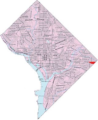
Ivy City is a small neighborhood in Northeast Washington, D.C., in the United States. About half the neighborhood is industrial or formerly industrial, dominated by warehouses. The Ivy City Yard, a railroad coach yard and maintenance facility for the passenger railroad Amtrak, is situated northwest across New York Avenue NE.

<span class="mw-page-title-main">Park View (Washington, D.C.)</span> Neighborhood of Washington, D.C.

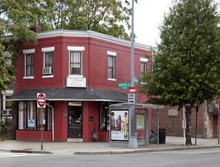
Park View is a neighborhood in Washington, D.C., located in Northwest D.C. The neighborhood is primarily residential with its main commercial corridor of shops and restauarants located along Georgia Avenue.

<span class="mw-page-title-main">Capitol View (Washington, D.C.)</span> Place in the United States

Capitol View is a neighborhood located in southeast Washington, D.C., in the United States. It is bounded by East Capitol Street to the north, Central Avenue SE to the southwest and south, and Southern Avenue SE to the southeast.

<span class="mw-page-title-main">Washington Highlands (Washington, D.C.)</span> Residential neighborhood, southeast Washington, D.C., United States

Washington Highlands is a residential neighborhood in Southeast Washington, D.C., in the United States. It lies within Ward 8.

<span class="mw-page-title-main">Kenilworth (Washington, D.C.)</span> Place in the United States

Kenilworth is a residential neighborhood in Northeast Washington, D.C., located on the eastern bank of the Anacostia River and just inside the D.C.-Maryland border. A large public housing complex, Kenilworth Courts, dominates the area. The neighborhood is famous for the Kenilworth Park and Aquatic Gardens, a national park whose centerpiece is a series of ponds carved out of Anacostia River marshland. Visitors come especially during June and July to see the beautiful blooming water lilies and lotus flowers. In 1895 the name “Kenilworth” was first applied to the area by white real estate developer Allen Mallery, who named this neighborhood after Kenilworth Castle in England, the ruins of which can still be seen today in Warwickshire. Kenilworth Park, which includes the Kenilworth-Parkside Recreation Center, also carries the neighborhood name, though most of the park's area is actually located adjacent to the modern neighborhoods of Parkside and Eastland Gardens.

<span class="mw-page-title-main">Marshall Heights (Washington, D.C.)</span> Residential neighborhood in Washington, D

Marshall Heights is a residential neighborhood in Southeast Washington, D.C. It is bounded by East Capitol Street, Central Avenue SE, Southern Avenue, Fitch Street SE, and Benning Road SE. It was an undeveloped rural area occupied by extensive African American shanty towns, but the neighborhood received nationwide attention after a visit by First Lady Eleanor Roosevelt in 1934, which led to extensive infrastructure improvements and development for the first time. In the 1950s, Marshall Heights residents defeated national legislation designed to raze and redevelop the neighborhood. Queen Elizabeth II of the United Kingdom visited the area in 1991, at a time when Marshall Heights was in the throes of a violent crack cocaine epidemic. Limited redevelopment has occurred in the neighborhood, which was the site of two notorious child murders in 1973.

<span class="mw-page-title-main">Horace McKenna</span>

Horace B. McKenna, S.J. was an American Catholic priest, founder of S.O.M.E., and advocate of the Sursum Corda Cooperative.

<span class="mw-page-title-main">St. Aloysius Church (Washington, D.C.)</span> Historic church in Washington, D.C., United States

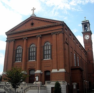
St. Aloysius Catholic Church is a Roman Catholic parish church at 19 I Street in the Near Northeast neighborhood of Washington, D. C. It is administered by the Jesuits since its founding and is named for St. Aloysius Gonzaga. It is often associated with Gonzaga College High School, to which it is physically connected. The church building is listed on the National Register of Historic Places. In 2012 the parish was closed and merged with Holy Redeemer church.

<span class="mw-page-title-main">Washington Harbour</span> Mixed-use development at 3000 and 3050 K Street, N.W., Washington, D.C., United States

Washington Harbour is a Class-A mixed-use development located at 3000 and 3050 K Street, N.W., in Washington, D.C., in the United States. The southern edge of the development borders the Potomac River on the Georgetown waterfront. Designed by Arthur Cotton Moore, the complex consists of two curved towers and three other buildings attached to them, all of which are in the Postmodern architectural style. The complex contains luxury condominia, offices, retail space, restaurants, and underground parking.

Vlastimil Koubek was an American architect who designed more than 100 buildings, most of them in the Washington metropolitan area, and whose total value topped $2 billion. Most of his work is Modernist in style, although he developed a few structures in other vernaculars. He created the site plan for the redevelopment of Rosslyn, Virginia, and his Ames Center anchored the area's economic recovery. He designed the World Building in Silver Spring, Maryland, which sparked redevelopment of that town's downtown; and the L'Enfant Plaza Hotel in Washington, D.C. In 1985, Washingtonian magazine called him one of 20 people "who in the past 20 years had the greatest impact on the way we live and who forever altered the look of Washington." In 1988, The Washington Post newspaper said his Willard Hotel renovation was one of 28 projects in the area that made a signal contribution to the "feel" and look of Washington, D.C.

<span class="mw-page-title-main">CityCenterDC</span> Mixed-use development in Washington, D.C.

CityCenterDC, sometimes colloquially called CityCenter, is a mixed-use development consisting of two condominium buildings, two rental apartment buildings, two office buildings, a luxury hotel, and public park in downtown Washington, D.C. It encompasses 2,000,000 square feet (190,000 m2) and covers more than five city blocks. The $950 million development began construction on April 4, 2011, on the site of the former Washington Convention Center—a 10.2-acre (4.1 ha) site bounded by New York Avenue NW, 9th Street NW, H Street NW, and 11th Street NW. Most of the development was completed and open for business by summer 2015. The luxury hotel Conrad Washington, DC, opened in February 2019.

<span class="mw-page-title-main">O Street Market</span> United States historic place

O Street Market, also known as Northern Market, is a historic structure located at 1400 7th Street NW in the Shaw neighborhood of Washington, D.C. Built in 1881, it is one of three 19th-century public market buildings still standing in the city, along with Eastern Market and Georgetown Market. The market was listed on the District of Columbia Inventory of Historic Sites in 1968 and the National Register of Historic Places in 1995. The most distinctive architectural element of the Gothic Revival building is its corner tower on 7th and O Streets.

<span class="mw-page-title-main">Eugene L. Stewart</span> American lawyer

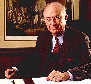
Eugene L. Stewart was an American lawyer and founder of the law firm Stewart and Stewart, an international law firm based in Washington D.C. He was known for his work in international trade law. He was the recipient of numerous awards including the John Carroll Award, an award given to Georgetown University Alumni whose achievements exemplify the ideals and traditions of the university. He is credited with being the leading organizer and founder of the Sursum Corda Cooperative in Washington, D.C., and was also a former law professor at Georgetown University.

<span class="mw-page-title-main">District of Columbia Housing Authority</span> Public housing agency in Washington, D.C., United States

The District of Columbia Housing Authority is an independent government agency whose mission is to provide affordable housing to extremely low- through moderate-income households, foster sustainable communities, and cultivate opportunities for residents to improve their lives throughout the eight wards of Washington, D.C.

<span class="mw-page-title-main">Mount Vernon Triangle</span> Place in the United States

Mount Vernon Triangle is a neighborhood and community improvement district in the northwest quadrant of Washington, D.C. The neighborhood is located adjacent to Mount Vernon Square. Originally a working-class neighborhood established in the 19th century, present-day Mount Vernon Triangle experienced a decline in the mid-20th century as it transitioned from residential to commercial and industrial use.

References

Notes
  1. The Temple Court Apartments consisted a 10-story tower with winding hallways, which allowed crime and drug dealing to occur out of sight. [1]
  2. In addition to the 520 residents at Temple Court Apartments, there were 40 residents displaced from the Golden Way mixed-use complex. [11]
Citations
  1. 1 2 3 4 5 6 7 8 Samuels, Robert (July 7, 2013). "In District, Affordable-Housing Plan Hasn't Delivered". The Washington Post. Retrieved August 20, 2015.
  2. Feinberg, Lawrence (September 25, 1968). "Montgomery Sets Up Study of Gun Control". The Washington Post.
  3. Monagan, John (1985). Horace – Priest of the Poor. Washington, D.C.: Georgetown University Press. ISBN   9780878404216.
  4. "Sursum Corda Lift Up Your Hearts". Journal of Housing. January 30, 1973.
  5. 1 2 "Georgetown's Highest Ranking of The Greatest Generation". The Georgetown Academy. February 1999.
  6. 1 2 Neibauer, Michael (August 19, 2015). "Sursum Corda subject of massive redevelopment play". Washington Business Journal. Retrieved August 20, 2015.
  7. Barron, Christina (April 8, 2013). "D.C. School Creates Its Own Farm". The Washington Post. Retrieved August 20, 2015.
  8. 1 2 Zumbrun, Joshua (December 14, 2007). "Partnership Is Chosen for Redevelopment". The Washington Post. p. B1.
  9. 1 2 Cauvin, Henri E. (November 1, 2006). "2 Men Found Guilty of Murder in Slaying of 14-Year-Old Witness". The Washington Post. Retrieved August 20, 2015.
  10. York, Jonathan (October 13, 2006). "Witness for the Prosecution". Washington City Paper. Retrieved August 20, 2015.
  11. 1 2 3 4 Andersen, Mark (October 29, 2014). "How D.C.'s Plan to Save Low-Income Housing Went Wrong". Washington City Paper. Retrieved August 20, 2015.
  12. Banister, Jon (November 19, 2018). "Toll Brothers Begins Demolition Of Sursum Corda Community, Plans 1,100-unit Project". Business Now. Retrieved November 20, 2018.

Further reading

38°54′19″N77°00′40″W / 38.9053°N 77.0112°W / 38.9053; -77.0112