
Mount Aspiring / Tititea is New Zealand's 23rd-highest mountain. The peak's altitude of 3,033 metres (9,951 ft) makes it the country's highest outside the Aoraki / Mount Cook region.
The Arawhata River is in the West Coast region of the South Island of New Zealand.

Pegasus Bay, earlier known as Cook's Mistake, is a bay on the east coast of the South Island of New Zealand, to the north of Banks Peninsula.
The Waipara River is a river in Canterbury in the South Island of New Zealand. The river is about 40 kilometres (25 mi) long, and its catchment area is 726 square kilometres (280 sq mi).

The Waimakariri River is one of the largest rivers in Canterbury, on the eastern coast of New Zealand's South Island. It flows for 151 kilometres (94 mi) in a generally southeastward direction from the Southern Alps across the Canterbury Plains to the Pacific Ocean.

The Weka Pass Railway is a New Zealand heritage railway based in Waipara, North Canterbury. It is operated on a 12.8 km length of the former Waiau Branch railway between Waipara and Waikari. The railway is operated by an incorporated society which consists solely of members and volunteers, and are largely resident in the city of Christchurch, 60 km to the south. The railway began carrying passengers in 1984 and is now well established locally and nationally.

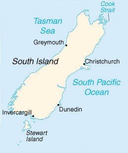
Waipara is a wine and tourism district in Canterbury, New Zealand, on the banks of the Waipara River. Its name translates to "Muddy Water", wai meaning water and para meaning mud.

New Zealand wine is produced in several of its distinct winegrowing regions. As an island country in the South Pacific Ocean, New Zealand has a largely maritime climate, although its elongated geography produces considerable regional variation from north to south. Like many other New World wines, New Zealand wine is usually produced and labelled as single varietal wines, or if blended, winemakers list the varietal components on the label. New Zealand is best known for its Marlborough Sauvignon Blanc, and more recently its dense, concentrated Pinot Noir from Marlborough, Martinborough and Central Otago.
Waimanu is a genus of early penguin which lived during the Paleocene, soon after the Cretaceous–Paleogene extinction event, around 62–60 million years ago. It was about the size of an emperor penguin. It is one of the most important bird fossils for understanding the origin and evolution of birds because of the time period it comes from, and the position of penguins near the base of the bird family tree.

Weka Pass is a locality in the northern Canterbury region of New Zealand's South Island between the towns of Waipara and Waikari.

The Main North Line, sometimes referred to as part of the South Island Main Trunk railway, is a railway line that runs north from Christchurch in New Zealand up the east coast of the South Island through Kaikōura and Blenheim to Picton. It is a major link in New Zealand's national rail network and offers a connection with roll-on roll-off ferries from Picton to Wellington. It was also the longest railway construction project in New Zealand's history, with the first stages built in the 1870s and not completed until 1945.

Alexandronectes is a genus of elasmosaurid plesiosaur, a type of long-necked marine reptile, that lived in the oceans of Late Cretaceous New Zealand. It contains one species, A. zealandiensis. Fossils of Alexandronectes were found in the Conway Formation of Canterbury, which can be dated to the Early Maastrichtian stage of the Cretaceous. Fossils of it were found around 1872 near the Waipara River, north of Christchurch, New Zealand.
The Greta River is a river in the Hurunui District of New Zealand. It flows north-east into the Hurunui River, which runs into the Pacific Ocean south of Cheviot, New Zealand. State Highway 1 follows the river for part of its route between Cheviot and Waipara. The locality of Greta Valley is to the east of the Greta River on the banks of the Waikari River. The river was named by local runholders Sir Charles Clifford and Sir Frederick Weld in the 1850s after the Greta River in Yorkshire.
MainPower New Zealand Limited is an electricity distribution company, based in Rangiora, New Zealand, responsible for electricity distribution to nearly 42,000 customers in the Canterbury region north of the Waimakariri River. MainPower was formed in 1993, after the Energy Companies Act 1992 required the North Canterbury Electric Power Board to reform into a commercial power company. More reforms in 1998 required electricity companies nationally to split their lines and retail businesses, with MainPower retaining its lines business and selling its retail business to Contact Energy.

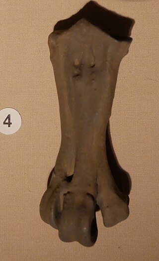
Crossvallia is an extinct genus of penguins. It includes two species, C. unienwillia and ?C. waiparensis. Their anatomy suggests that the genus is closely related to the Anthropornithinae.

Muriwaimanu is an extinct genus of early penguin from the Paleocene Waipara Greensand of New Zealand. Only the type species M. tuatahi is known.
Sequiwaimanu is an extinct genus of early penguin from the Waipara Greensand of New Zealand. The type species, S. rosieae, was named and described by Gerald Mayr in 2018.
Waipara River may refer to the following New Zealand rivers:
The Waipara Greensand is a geological rock unit found in Canterbury, New Zealand. It dates from just after the Cretaceous–Paleogene extinction event, the Selandian and Thanetian, around 62–58 million years ago in the Palaeocene. It is well known for its fossils, particularly for containing the oldest penguins (Sphenisciformes) and also containing shark and fish fossils.

The Canterbury wine region is a New Zealand wine region and geographical indication that covers wine made anywhere within the Canterbury Region excluding the Kaikōura District, an area of some 44,500 square kilometres (17,200 sq mi) in the South Island.


