Adelaide–Mannum Road

Last updated • 2 min readFrom Wikipedia, The Free Encyclopedia

Adelaide–Mannum Road

Northcote Terrace, North East Road, Torrens Valley Road, Randell Road, Adelaide Road

Australia South Australia location map.svg
Red pog.svg
West end
Red pog.svg
East end
Coordinates
General information
TypeRoad
Length78.7 km (49 mi) [1]
Route number(s)
  • AUS Alphanumeric Route A10.svg A10 (1998–present)
    (Gilberton–Houghton)
  • AUS Alphanumeric Route B10.svg B10 (1998–present)
    (Houghton–Birdwood)
  • AUS Alphanumeric Route B35.svg B35 (1998–present)
    (Tungkillo–Palmer)
  • AUS Alphanumeric Route B36.svg B36 (1998–present)
    (Palmer–Mannum)
Major junctions
West endAUS Alphanumeric Route R1.svg Mann Road
AUS Alphanumeric Route R1.svg Park Road
North Adelaide
 
East endAdelaide Road
Mannum, South Australia
Location(s)
Region Eastern Adelaide, Adelaide Hills, Murray and Mallee [2]
Major suburbs Klemzig, Modbury, Houghton, Chain of Ponds, Gumeracha, Birdwood, Tungkillo, Palmer

Adelaide–Mannum Road is a road that runs through the northern Adelaide Hills between the South Australian capital, Adelaide and Mannum on the Murray River. It is designated route A10 in the metropolitan area and B10 in rural areas, and is 79 kilometres in length. This name covers many consecutive streets and is not widely known to most drivers, as the entire allocation is still best known as by the names of its constituent parts: Northcote Terrace, North East Road, Torrens Valley Road, Randell Road and Adelaide Road. This article will deal with the entire length of the corridor for sake of completion, as well to avoid confusion between declarations.

Contents

Route

Northcote Terrace starts at the intersection of Robe Terrace and Park Road/Mann Road in North Adelaide, about 500 metres away from the beginning of Adelaide's O-Bahn Busway, changes name to North East Road a kilometre later to become a major arterial road that travels, as its name suggests, through the north-eastern suburbs of Adelaide. [3] It continues through Adelaide's north-east growth corridor, beyond it to the distinctly less-urban region of Houghton, where it meets in an intersection with the Lower North East Road, leading back to Adelaide's more easterly suburbs. Just beyond Millbrook Reservoir, the road changes name to Torrens Valley Road and continues east, then just east of Birdwood turns off to become Randell Road, continuing east until it reaches the western edges of Mannum, where it changes name for the final time to Adelaide Road.

History

The road was first built in the 1840s to facilitate the growth and development of the towns and settlements along its length. It played a role in the gold rush of the 1860s. Today, the area boasts many tourist and historical sites, wineries and natural attractions, although only a few towns exist as more than historical sites.

Major intersections

LGA [4] Location [1] [5] km [1] miDestinationsNotes
Walkerville North AdelaideMedindieGilberton tripoint0.00.0AUS Alphanumeric Route R1.svg Mann Road (n/bound)/Park Road (s/bound) (R1 south)  Adelaide Western terminus of road and route A10
AUS Alphanumeric Route R1.svg Robe Terrace (R1 west)  Adelaide, Port Adelaide No right turn southbound into Robe Terrace
Walkerville Terrace (northeast)  Gilberton
Walkerville–Port Adelaide Enfield borderGilberton–Collinswood border1.00.62Nottage Terrace (west)  Prospect
Stephen Terrace (southeast)  St Peters
Name transition: Northcote Terrace (south), North East Road (northeast)
Vale ParkManningham border2.61.6AUS Alphanumeric Route A17.svg Taunton Road (A17 northwest)  Northfield
AUS Alphanumeric Route A17.svg Ascot Avenue (A17 southeast)  Glen Osmond
Port Adelaide Enfield GreenacresHampstead GardensKlemzig tripoint4.52.8 Muller Road   Prospect, Kilkenny
Tea Tree Gully ModburyHolden HillGilles PlainsValley View quadripoint8.85.5AUS Alphanumeric Route A16.svg Grand Junction Road (A16)  Port Adelaide, Gepps Cross, Houghton
Modbury 10.26.3AUS Alphanumeric Route A18.svg McIntyre Road (A18)  Parafield, Paralowie
RidgehavenSt AgnesTea Tree Gully tripoint14.38.9AUS Alphanumeric Route A11.svg Hancock Road (A11)  Golden Grove, Salisbury Heights
Adelaide Hills Houghton 19.312.0AUS Alphanumeric Route A16.svg Lower North East Road (A16)  Port Adelaide, Gepps Cross Route transition: A10 west, B10 east
MillbrookChain of Ponds border27.116.8AUS Alphanumeric Route B31.svg Tippett Road (B31 north)  Campbelltown, Castambul Concurrency of routes B10 and B31
Chain of Ponds 27.517.1AUS Alphanumeric Route B31.svg South Para Road (B31 south)  Williamstown, Lyndoch
Chain of Ponds–Cudlee CreekGumeracha tripoint29.918.6 Gorge Road   Cudlee Creek Name transition: North East Road (west), Torrens Valley Road (east)
Birdwood 40.024.9AUS Alphanumeric Route B34.svg Warren Road (B34 north)  Mount Crawford, Williamstown Concurrency of routes B10 and B34
41.826.0AUS Alphanumeric Route B34.svg Onkaparinga Valley Road (B34 south)  Mount Torrens, Bridgewater
Adelaide Hills–Barossa borderBirdwood–Mount Pleasant border46.228.7AUS Alphanumeric Route B10.svg Torrens Valley Road (B10 northeast)  Mount Pleasant, Nurioopta Name transition: Torrens Valley Road (southwest), Randell Road (east)
Route transition: B10 (southwest), unallocated (east)
Mid Murray Tungkillo 51.632.1AUS Alphanumeric Route B35.svg Tungkillo Road (B35 north)  Mount Pleasant, Mount Crawford Route transition: unallocated (west), B35 (east)
Palmer 63.139.2AUS Alphanumeric Route B35.svg Reedy Creek Road (B35 south)  Murray Bridge Route transition: B35 (south), B36 (east)
Mannum 75.747.0Ridley Road (north)  Angas Valley, Sedan
AUS Alphanumeric Route B36.svg Mannum Road (B36 south)  Murray Bridge
Name transition: Randell Road (west), Adelaide Road (east)
Route transition: B36 (south), unallocated (east)
78.748.9Randell Street  Mannum Eastern terminus of road

Related Research Articles

<span class="mw-page-title-main">Main North Road</span> Road in South Australia

Main North Road is the major north–south arterial route through the suburbs north of the Adelaide City Centre in the city of Adelaide, South Australia, and linking to Gawler on Adelaide's outer north-eastern fringes.

Greenhill Road is a major road in Adelaide, South Australia, that provides a connection to the eastern and hills suburbs. Its western section, running along the south side of Adelaide Parklands, forms part of Adelaide's City Ring Route.

South Road and its southern section as Main South Road outside of Adelaide is a major north–south conduit connecting Adelaide and the Fleurieu Peninsula, in South Australia. It is one of Adelaide's most important arterial and bypass roads. As South Road, it is designated part of route A2 within suburban Adelaide. As Main South Road, it is designated part of routes A13 and B23.

Portrush Road is a major arterial route through the eastern suburbs of Adelaide, the capital of South Australia. This name covers many consecutive streets and is not widely known to most drivers except for the southernmost section, as the entire allocation is still best known as by the names of its constituent parts: Hampstead Road, Taunton Road, Ascot Avenue, Lower Portrush Road, and Portrush Road proper. This article will deal with the entire length of the corridor for sake of completion, as well to avoid confusion between declarations. Portrush Road is designated route A17.

<span class="mw-page-title-main">Goodwood Road, Adelaide</span>

Goodwood Road is a major north–south arterial road, approximately 10 kilometres long, in Adelaide, South Australia. It runs between the Adelaide city centre and Adelaide's southern suburbs of Pasadena and Panorama.

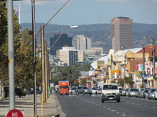
Fullarton Road is a main road in the South Australian capital city of Adelaide.

<span class="mw-page-title-main">Cross Road, Adelaide</span>

Cross Road is a major arterial road that travels east–west through the inner southern suburbs of the Australian city of Adelaide. It is designated route A3.

<span class="mw-page-title-main">Anzac Highway</span> Highway in Adelaide

Anzac Highway is an 8.7-kilometre-long (5.4 mi) main arterial road heading southwest from the city of Adelaide, the capital of South Australia, to the beachside suburb of Glenelg.

<span class="mw-page-title-main">Port Road, Adelaide</span>

Port Road is a major road in Adelaide, South Australia connecting the Adelaide city centre with Port Adelaide. It is 12 km (7.5 mi) long, and is designated part of route R1 within central Adelaide, and beyond as route A7.

<span class="mw-page-title-main">Glen Osmond Road</span>

Glen Osmond Road is a major section of the Princes Highway in the city of Adelaide, South Australia. Connecting the Adelaide city centre with the Adelaide Hills via the South Eastern Freeway; Glen Osmond Road carries half of Adelaide's freight traffic and is the major commuter route from the southern Adelaide Hills. It is designated part of route A1.

Salisbury Highway is a 15 kilometre major connecting road in the northern suburbs of the Adelaide metropolitan area. It is designated part of route A9.

<span class="mw-page-title-main">Torrens Road</span>

Torrens Road is an arterial road in the northwestern suburbs of Adelaide, Australia. The road is aligned southeast to northwest and is parallel with Port Road for most of its length.

<span class="mw-page-title-main">Sir Donald Bradman Drive, Adelaide</span> Road in Adelaide, South Australia

Sir Donald Bradman Drive is a major arterial road that travels east–west through the western suburbs of Adelaide, South Australia. It is the main route from the Adelaide city centre to the Adelaide Airport.

<span class="mw-page-title-main">Tapleys Hill Road</span>

Tapleys Hill Road is a section of the north–south arterial road which runs parallel to the coast through western Adelaide, Australia. This entire allocation is best known as by the names of its constituent parts: Tapleys Hill Road proper, Brighton Road, Ocean Boulevard, Lonsdale Road, Dyson Road, Murray Road, and Gawler Street. This article deals with the entire length of the corridor for sake of completion, as well to avoid confusion between declarations. The section Tapleys Hill Road is a remnant of an historic road, and no longer runs to the geographic feature Tapleys Hill.

Lower North East Road is an arterial road in the northeastern suburbs of Adelaide, South Australia. It links the north-eastern corner of Adelaide to Houghton in the Adelaide Hills, and is an urban alternative to North East Road.

<span class="mw-page-title-main">North–South Motorway</span> Motorway in Adelaide, South Australia

The North–South Motorway is a partially complete motorway traversing the inner western suburbs of Adelaide, from Waterloo Corner in the north to Bedford Park in the south. Progressively constructed in stages since 2010, once complete it will replace the adjacent South Road as Adelaide's main north–south roadway. It will form the central section of the North–South Corridor, being flanked north and south by the Northern Expressway and Southern Expressway, respectively. It is designated part of route M2.

Marion Road is a north–south arterial road through the western suburbs of Adelaide, South Australia, named after its traversal through the suburb of Marion and the local government area of City of Marion. It is designated part of route A14.

Regency Road is a main east-west road forming a continuous connection between the inner northern suburbs of Adelaide, South Australia. Located approximately 6 kilometres (3.7 mi) north of the city centre, Regency Road carries a large amount of freight traffic, being located near Regency Park and the Churchill Road industrial area.

Churchill Road is an arterial road in the inner northern suburbs of Adelaide, Australia.

McIntyre Road is an arterial road crossing through northern and northeastern suburbs of Adelaide in South Australia. It is designated route A18.

References

  1. 1 2 3 Google (7 June 2022). "Adelaide-Mannum Road" (Map). Google Maps . Google. Retrieved 7 June 2022.
  2. "Location SA Map viewer with regional layers". Government of South Australia . Retrieved 16 June 2022.
  3. 2003 Adelaide Street Directory, 41st Edition. UBD (A Division of Universal Press Pty Ltd). 2003. ISBN   0-7319-1441-4.
  4. "Location SA Map viewer with LGA layers". Government of South Australia . Retrieved 16 June 2022.
  5. "Location SA Map viewer with suburb layers". Government of South Australia . Retrieved 16 June 2022.

See also