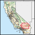
California's 23rd congressional district

Last updated

California's 23rd congressional district
California's 23rd congressional district (since 2023).svg
California's 23rd congressional district
Interactive map of district boundaries since 2023 (Used in the 2022 elections)
Representative
Population (2023)768,047 [1]
Median household
income
$74,906 [1]
Ethnicity
Cook PVI R+8 [2]

California's 23rd congressional district is a congressional district in the U.S. state of California. The district is represented in the 118th United States Congress by Jay Obernolte.

Contents

Following the 2020 United States redistricting cycle, the district is anchored in San Bernardino County, and also includes parts of Kern and Los Angeles counties. It is mostly within the Mojave Desert. Cities in the new 23rd district include Victorville, Hesperia, Adelanto, Apple Valley, Barstow, Twentynine Palms, Big Bear Lake, California City, Loma Linda, Yucaipa, southern Redlands, and small portions of Highland and San Bernardino. [3] It also has one of the highest active-duty military populations in the country, containing Fort Irwin National Training Center, Marine Corps Logistics Base Barstow, and Marine Corps Air Ground Combat Center Twentynine Palms.

History

From 2003 to 2013 the district ran along the Pacific coasts of Ventura, Santa Barbara, and San Luis Obispo counties. Major cities in the district included Santa Barbara, San Luis Obispo, Ventura, and Oxnard. [4] Before redistricting by the California Citizens Redistricting Commission in 2011, California's 23rd congressional district was one of the narrowest districts in the United States, stretching along the Pacific coast from Oxnard to the Monterey County line. It was often referred to as "the district that disappears at high tide" [5] or the "ribbon of shame". [6] This area is now divided between the 24th and 26th districts, while the current 23rd covers much of the territory that was previously in the 22nd district.

Recent election results from statewide races

YearOfficeResults [7] [8] [9] [10] [11]
2008 President McCain 57% - 42%
2012 President Romney 58% - 42%
2016 President Trump 55% - 40%
2018 Governor Cox 60% - 40%
Attorney General Bailey 58% - 42%
2020 President Trump 54% - 44%
2022 Senate (Reg.) Meuser 59% - 41%
Governor Dahle 61% - 39%
Lt. Governor Underwood Jacobs 60% - 40%
Secretary of State Bernosky 60% - 40%
Attorney General Hochman 60% - 40%
Treasurer Guerrero 61% - 39%
2024 President Trump 57% - 40%
Senate (Reg.) Garvey 59% - 41%

Composition

#CountySeatPopulation
29 Kern Bakersfield 913,820
37 Los Angeles Los Angeles 9,663,345
71 San Bernardino San Bernardino 2,195,611

As of the 2020 redistricting, California's 23rd congressional district is located in the region of the state covering the Mojave Desert. It encompasses the majority of San Bernardino, and parts of Kern and Los Angeles Counties.

San Bernardino County is split between this district, the 25th district, the 28th district, the 33rd district, and the 40th district. The 23rd, 28th and 33rd are partitioned by San Bernardino National Forest, Manzanita Rd, Highway 15, Cajon Blvd, W Kenwood Ave, Highway 215, W Meyers Rd, Ohio Ave, Pine Ave, Bailey act, Highway 206, Devils Canyon Rd, Cloudland Truck Trail, Cloudland Cutoff, Hill Dr, W 54th St, E Hill Dr, Bonita Vista Dr, Sterling Ave, Argyle Ave, E Marshall Blvd, Rockford Ave, Lynwood Dr, La Praix St, Orchid Dr, Denair Ave, Highland Ave, Orchard Rd, Arroyo Vista Dr, Church St, Greensport Rd, Florida St, Garnet St, Nice Ave, Crafton Ave, 5th Ave, Walnut St, 6th Ave, S Wabash Ave, E Citrus Ave, N Church St, Southern California Regional Rail A, Tennessee St, Highway 10, California St, E Washington St, and S Barton Rd. The 23rd and 25th are partitioned by Power Line Rd, Telephone Pole Line Rd, Cadiz Rd, Arizona & California Rail, San Bernardino National Forest, East Mojave Heritage Trail, Sunflower Springs Spur, Sunflower Springs Rd, Needles Freeway, Mountain Springs Rd, Goffs Rd, and Walter Rd. The 23rd district takes in parts of the cties of Redlands, Highland, and San Bernardino, the cities of Victorville, Barstow, Twentynine Palms, Adelanto, Yucaipa, Loma Linda, Apple Valley, Hesperia, Colton, and Big Bear Lake, the town of Yucca Valley, and the census-designated places Searles Valley, Fort Irwin, Baker, Yermo, Silver Lakes, Piñon Hills, Phelan, Oak Hills, Mountain View Acres, Spring Valley Lake, Mentone, Oak Glen, Crestline, Lake Arrowhead, Running Springs, Lucerne Valley, Big Bear City, Morongo Valley, Joshua Tree, Homestead Valley

Kern County is split between this district and the 20th district. They are partitioned by the Mojave-Barstow Highway, Treescape Rd, Oak Creek Rd, Anajanette Ave, 70th St W, Highway 58, Homer Hansen Private Rd, Aerospace Highway, Redrock Randsburgs Rd, Garlock Rd, Iron Canyon, and Union Pacific. The 23rd district takes in part of the census-designated place of Mojave, the city of California City and the census-designated places North Edwards, Boron, Randsburg, and Johannesburg.

Los Angeles County is split between this district, the 27th district, and the 28th district. They are partitioned by Angeles National Forest, Linda Mesa Rd, San Gabriel Mountains, Fort Tejon Rd, 121st St E, 123rd St E, 126th St E, Highway N6, Highway 138, 136th St E, Longview Rd, E Avenue S, 140th St E, E Avenue H, 120th St E. The 23rd district takes in the census-designated place Lake Los Angeles.

Cities and CDPs with 10,000 or more people

2,500 – 10,000 people

List of members representing the district

RepresentativePartyYearsCong
ress(es)
Electoral historyDistrict location
District created January 3, 1943
Ed V. Izac, 1940.jpg
Edouard Izac
(San Diego)
Democratic January 3, 1943 –
January 3, 1947
78th
79th
Redistricted from the 20th district and re-elected in 1942.
Re-elected in 1944.
Lost re-election.
1943–1953
San Diego
Charles K. Fletcher (California Congressman) 2.jpg
Charles K. Fletcher
(San Diego)
Republican January 3, 1947 –
January 3, 1949
80th Elected in 1946.
Lost re-election.
Clinton D. McKinnon (California Congressman).jpg
Clinton D. McKinnon
(San Diego)
Democratic January 3, 1949 –
January 3, 1953
81st
82nd
Elected in 1948.
Re-elected in 1950.
Retired to run for U.S. senator.
Clyde Doyle, 1950.jpg
Clyde Doyle
(South Gate)
Democratic January 3, 1953 –
March 14, 1963
83rd
84th
85th
86th
87th
88th
Redistricted from the 18th district and re-elected in 1952.
Re-elected in 1954.
Re-elected in 1956.
Re-elected in 1958.
Re-elected in 1960.
Re-elected in 1962.
Died.
1953–1973
Los Angeles
VacantMarch 14, 1963 –
June 11, 1963
88th
Del M. Clawson.jpg
Del M. Clawson
(Downey)
Republican June 11, 1963 –
January 3, 1975
88th
89th
90th
91st
92nd
93rd
Elected to finish Doyle's term.
Re-elected in 1964.
Re-elected in 1966.
Re-elected in 1968.
Re-elected in 1970.
Re-elected in 1972.
Redistricted to the 33rd district .
1973–1975
Los Angeles, Orange
Thomas M. Rees.jpg
Thomas M. Rees
(Los Angeles)
Democratic January 3, 1975 –
January 3, 1977
94th Redistricted from the 26th district and re-elected in 1974.
Retired.
1975–1983
Los Angeles
Abeilenson.jpg
Anthony Beilenson
(Los Angeles)
Democratic January 3, 1977 –
January 3, 1993
95th
96th
97th
98th
99th
100th
101st
102nd
Elected in 1976.
Re-elected in 1978.
Re-elected in 1980.
Re-elected in 1982.
Re-elected in 1984.
Re-elected in 1986.
Re-elected in 1988.
Re-elected in 1990.
Redistricted to the 24th district .
1983–1993
Los Angeles (northern L.A. suburbs)
Elton Gallegly Portrait.jpg
Elton Gallegly
(Simi Valley)
Republican January 3, 1993 –
January 3, 2003
103rd
104th
105th
106th
107th
Redistricted from the 21st district and re-elected in 1992.
Re-elected in 1994.
Re-elected in 1996.
Re-elected in 1998.
Re-elected in 2000.
Redistricted to the 24th district .
1993–2003
Santa Barbara (Carpinteria), Ventura
Lois Capps 2011 official photo.jpg
Lois Capps
(Santa Barbara)
Democratic January 3, 2003 –
January 3, 2013
108th
109th
110th
111th
112th
Redistricted from the 22nd district and re-elected in 2002.
Re-elected in 2004.
Re-elected in 2006.
Re-elected in 2008.
Re-elected in 2010.
Redistricted to the 24th district .
2003–2013
Coastal San Luis Obispo, Santa Barbara, Ventura
House Maj. Leader Kevin McCarthy official photo.jpg
Kevin McCarthy
(Bakersfield)
Republican January 3, 2013 –
January 3, 2023
113th
114th
115th
116th
117th
Redistricted from the 22nd district and re-elected in 2012.
Re-elected in 2014.
Re-elected in 2016.
Re-elected in 2018.
Re-elected in 2020.
Redistricted to the 20th district .
2013–2023
California US Congressional District 23 (since 2013).tif
Southern Central Valley including parts of Bakersfield
Jay Obernolte 117th U.S Congress.jpg
Jay Obernolte
(Big Bear Lake)
Republican January 3, 2023 –
present
118th
119th
Redistricted from the 8th district and re-elected in 2022.
Re-elected in 2024.
2023–present
California's 23rd congressional district (since 2023) (new version).svg
Most of the area of San Bernardino County and parts of Kern and Los Angeles counties

Election results

1942

1942 election [12]
PartyCandidateVotes%
Democratic Edouard Izac (Incumbent) 42,864 50.5%
Republican James B. Abbey42,08749.5%
Total votes84,951 100.0%
Turnout  
Democratic hold

1944

1944 election [13]
PartyCandidateVotes%
Democratic Edouard Izac (Incumbent) 86,707 55.1%
Republican James B. Abbey70,78744.9%
Total votes157,494 100.0%
Turnout  
Democratic hold

1946

1946 election [14]
PartyCandidateVotes%
Republican Charles K. Fletcher 69,411 56.3%
Democratic Edouard Izac (Incumbent)53,89843.7%
Total votes123,309 100.0%
Turnout  
Republican gain from Democratic

1948

1948 election [15]
PartyCandidateVotes%
Democratic Clinton D. McKinnon 112,534 55.8%
Republican Charles K. Fletcher (Incumbent)87,13843.2%
Progressive Harry C. Steinmetz2,0171.0%
Total votes201,689 100.0%
Turnout  
Democratic gain from Republican

1950

1950 election [16]
PartyCandidateVotes%
Democratic Clinton D. McKinnon (Incumbent) 94,137 51%
Republican Leslie E. Gehres 90,39849%
Total votes184,535 100.0%
Turnout  
Democratic hold

1952

1952 election [17]
PartyCandidateVotes%
Democratic Clyde Doyle (Incumbent) 138,356 87.5%
Progressive Olive T. Thompson17,50111.1%
Republican C. Cleveland (write-in)2,3291.4%
Total votes158,186 100.0%
Turnout  
Democratic hold

1954

1954 election [18]
PartyCandidateVotes%
Democratic Clyde Doyle (Incumbent) 90,729 70.9%
Republican Frank G. Bussing34,91127.3%
Progressive Olive T. Thompson2,2931.8%
Total votes127,933 100.0%
Turnout  
Democratic hold

1956

1956 election [19]
PartyCandidateVotes%
Democratic Clyde Doyle (Incumbent) 120,109 70.9%
Republican E. Elgie "Cal" Calvin49,19829.1%
Total votes169,207 100.0%
Turnout  
Democratic hold

1958

1958 election [20]
PartyCandidateVotes%
Democratic Clyde Doyle (Incumbent) 140,817 100.0%
Turnout  
Democratic hold

1960

1960 election [21]
PartyCandidateVotes%
Democratic Clyde Doyle (Incumbent) 148,415 74.2%
Republican Emmett A. Schwartz51,54825.8%
Total votes199,963 100.0%
Turnout  
Democratic hold

1962

1962 election [22]
PartyCandidateVotes%
Democratic Clyde Doyle (Incumbent) 83,269 64.2%
Republican Emmett A. Schwartz46,48835.8%
Total votes129,757 100.0%
Turnout  
Democratic hold

1963 (Special)

1963 special election [23]
PartyCandidateVotes%
Republican Del M. Clawson 53.2%
Democratic Carley V. Porter35.4%
Democratic Maurice H. Quigley4.7%
Democratic Armand R. Porter2.7%
Democratic James Earle Christo1.4%
Democratic Lynn W. Johnston1.4%
Republican Harold R. "Hal" Bennett0.6%
Republican Harry L. Butler0.6%
Total votes100.0%
Turnout  
Republican gain from Democratic

1964

1964 election [24]
PartyCandidateVotes%
Republican Del M. Clawson (Incumbent) 90,721 55.4%
Democratic H. O. Van Pettin72,90344.6%
Total votes163,624 100.0%
Turnout  
Republican hold

1966

1966 election [25]
PartyCandidateVotes%
Republican Del M. Clawson (Incumbent) 93,320 67.4%
Democratic Ed O'Connor45,14132.6%
Total votes138,461 100.0%
Turnout  
Republican hold

1968

1968 election [26]
PartyCandidateVotes%
Republican Del M. Clawson (Incumbent) 95,628 64.9%
Democratic Jim Sperrazzo51,60635.1%
Total votes147,234 100.0%
Turnout  
Republican hold

1970

1970 election [27]
PartyCandidateVotes%
Republican Del M. Clawson (Incumbent) 77,346 63.3%
Democratic G. L. "Jerry" Chapman44,76736.7%
Total votes122,113 100.0%
Turnout  
Republican hold

1972

1972 election [28]
PartyCandidateVotes%
Republican Del M. Clawson (Incumbent) 118,731 61.4%
Democratic Conrad G. Tuohey74,56138.6%
Total votes193,292 100.0%
Turnout  
Republican hold

1974

1974 election [29]
PartyCandidateVotes%
Democratic Thomas M. Rees 119,239 71.4%
Republican Jack E. Roberts47,61528.6%
Total votes166,854 100.0%
Turnout  
Democratic hold

1976

1976 election [30]
PartyCandidateVotes%
Democratic Anthony C. Beilenson 130,619 60.2%
Republican Thomas F. Bartman86,43439.8%
Total votes217,053 100.0%
Turnout  
Democratic hold

1978

1978 election [31]
PartyCandidateVotes%
Democratic Anthony C. Beilenson (Incumbent) 117,498 65.6%
Republican Joseph Barbara61,49634.4%
Total votes178,994 100.0%
Turnout  
Democratic hold

1980

1980 election [32]
PartyCandidateVotes%
Democratic Anthony C. Beilenson (Incumbent) 126,020 63.2%
Republican Robert "Bob" Winckler62,74231.5%
Libertarian Jeffrey P. Lieb10,6235.3%
Total votes199,385 100.0%
Turnout  
Democratic hold

1982

1982 election [33]
PartyCandidateVotes%
Democratic Anthony C. Beilenson (Incumbent) 120,788 59.6%
Republican David Armor82,03140.4%
Total votes202,819 100.0%
Turnout  
Democratic hold

1984

1984 election [34]
PartyCandidateVotes%
Democratic Anthony C. Beilenson (Incumbent) 140,461 61.6%
Republican Claude W. Parrish84,09336.9%
Libertarian Larry Leathers3,5801.6%
Total votes228,134 100.0%
Turnout  
Democratic hold

1986

1986 election [35]
PartyCandidateVotes%
Democratic Anthony C. Beilenson (Incumbent) 121,468 65.7%
Republican George Woolverton58,74631.8%
Peace and Freedom Tom Hopke2,5211.4%
Libertarian Taylor Rhodes2,0191.1%
Total votes184,754 100.0%
Turnout  
Democratic hold

1988

1988 election [36]
PartyCandidateVotes%
Democratic Anthony C. Beilenson (Incumbent) 147,858 63.5%
Republican Jim Salomon77,18433.1%
Libertarian John R. Vernon4,5031.9%
Peace and Freedom John Honigsfeld3,3161.4%
No partyWrite-ins180.0%
Total votes232,879 100.0%
Turnout  
Democratic hold

1990

1990 election [37]
PartyCandidateVotes%
Democratic Anthony C. Beilenson (Incumbent) 103,141 61.7%
Republican Jim Salomon57,11834.2%
Peace and Freedom John Honigsfeld6,8344.1%
Total votes167,093 100.0%
Turnout  
Democratic hold

1992

1992 election [38]
PartyCandidateVotes%
Republican Elton Gallegly (Redistricted incumbent) 115,504 54.3%
Democratic Anita Perez Ferguson 88,22541.4%
Libertarian Jay C. Wood9,0914.3%
No partyDunbar (write-in)610.0%
Total votes212,881 100.0%
Turnout  
Republican hold

1994

1994 election [39]
PartyCandidateVotes%
Republican Elton Gallegly (Incumbent) 114,043 66.17%
Democratic Kevin Ready47,34527.47%
Libertarian Bill Brown6,4813.76%
Green Robert T. Marston4,4572.59%
No partyNagode (write-in)140.01%
Total votes172,340 100.0%
Turnout  
Republican hold

1996

1996 election [40]
PartyCandidateVotes%
Republican Elton Gallegly (Incumbent) 118,880 59.6%
Democratic Robert Unruhe70,03535.2%
Libertarian Gail Lightfoot8,3464.1%
Natural Law Stephen Hospodar2,2461.1%
Total votes199,507 100.0%
Turnout  
Republican hold

1998

1998 election [41]
PartyCandidateVotes%
Republican Elton Gallegly (Incumbent) 96,362 60.06%
Democratic Daniel "Dan" Gonzalez64,06839.94%
Total votes160,430 100.0%
Turnout  
Republican hold

2000

2000 election [42]
PartyCandidateVotes%
Republican Elton Gallegly (Incumbent) 119,479 54.1%
Democratic Michael Case89,91840.7%
Reform Cary Savitch6,4733.0%
Libertarian Roger Peebles3,7081.6%
Natural Law Stephen P. Hospodar1,4560.6%
Total votes221,034 100.0%
Turnout  
Republican hold

2002

2002 election [43]
PartyCandidateVotes%
Democratic Lois Capps (Redistricted incumbent) 95,752 59.1%
Republican Beth Rogers62,60438.6%
Libertarian James E. Hill3,8662.3%
Total votes162,222 100.0%
Turnout  
Democratic hold

2004

2004 election [44]
PartyCandidateVotes%
Democratic Lois Capps (Incumbent) 153,980 63.1%
Republican Don Regan83,92634.3%
Libertarian Michael Favorite6,3912.6%
Total votes244,297 100.0%
Turnout  
Democratic hold

2006

2006 election [45]
PartyCandidateVotes%
Democratic Lois Capps (Incumbent) 114,661 65.2%
Republican Victor G. Tognazzini61,27234.8%
No partyH.A. Gardner Jr. (write-in)180.0%
Total votes175,951 100.0%
Turnout  
Democratic hold

2008

2008 United States House of Representatives elections in California
PartyCandidateVotes%
Democratic Lois Capps (Incumbent) 171,403 68.07%
Republican Matt Kokkonen80,38531.93%
Total votes251,788 100.00%
Turnout  77.41%
Democratic hold

2010

2010 election [46]
PartyCandidateVotes%
Democratic Lois Capps (Incumbent) 111,768 57.8%
Republican Tom Watson72,74437.6%
Libertarian Darrell M. Stafford3,3261.7%
No partyJohn V. Hager5,6252.9%
Total votes193,463 100.0%
Turnout  
Democratic hold

2012

2012 election [47]
PartyCandidateVotes%
Republican Kevin McCarthy (Redistricted incumbent) 158,161 73.2%
No party preference Terry Phillips 57,84226.8%
Total votes216,003 100.0%
Republican hold

2014

2014 election
Primary election
PartyCandidateVotes%
Republican Kevin McCarthy (Incumbent)58,33499.1%
Democratic Raul Garcia (write-in)3130.5%
Republican Mike Biglay (write-in)1570.3%
No party preference Ronald L. Porter (write-in)360.1%
Libertarian Gail K. Lightfoot (write-in)310.1%
Green Noah Calugaru (write-in)30.01%
Total votes58,871 100.0%
General election
Republican Kevin McCarthy (Incumbent) 100,317 74.8%
Democratic Raul Garcia33,72625.2%
Total votes134,043 100.0%
Republican hold

2016

2016 election [47]
PartyCandidateVotes%
Republican Kevin McCarthy (Incumbent) 167,116 69.2%
Democratic Wendy Reed74,46830.8%
Total votes241,584 100.0%
Republican hold

2018

2018 election [48]
PartyCandidateVotes%
Republican Kevin McCarthy (Incumbent) 131,113 63.7%
Democratic Tatiana Matta74,66136.3%
Total votes205,774 100.0%
Republican hold

2020

2020 election
Primary election
PartyCandidateVotes%
Republican Kevin McCarthy (incumbent)107,89766.5
Democratic Kim Mangone54,37533.5
Total votes162,272 100.0
General election
Republican Kevin McCarthy (incumbent) 190,222 62.1
Democratic Kim Mangone115,89637.9
Total votes306,118 100.0
Republican hold

Kevin McCarthy was redistricted to California's 20th congressional district prior to the 2022 election.

2022

2022 election
Primary election
PartyCandidateVotes%
Republican Jay Obernolte (incumbent)57,98860.9
Democratic Derek Marshall20,77621.8
Democratic Bianca A. Gómez16,51617.3
Total votes95,280 100.0
General election
Republican Jay Obernolte (incumbent) 103,197 61.0
Democratic Derek Marshall65,90839.0
Total votes169,105 100.0
Republican hold

Historical district boundaries

2013 - 2023 California US Congressional District 23 (since 2013).tif
2013 – 2023

See also

Related Research Articles

<span class="mw-page-title-main">San Bernardino County, California</span> County in southern California, United States

San Bernardino County, officially the County of San Bernardino and sometimes abbreviated as S.B. County, is a county located in the southern portion of the U.S. state of California, and is located within the Inland Empire area. As of the 2020 U.S. Census, the population was 2,181,654, making it the fifth-most populous county in California and the 14th-most populous in the United States. The county seat is San Bernardino.

<span class="mw-page-title-main">Victorville, California</span> City in California, United States

Victorville is a city in Victor Valley in San Bernardino County, California. Its population as of the 2020 census was 134,810.

<span class="mw-page-title-main">Mojave River</span> River in California, United States

The Mojave River is an intermittent river in the eastern San Bernardino Mountains and the Mojave Desert in San Bernardino County, California, United States. Most of its flow is underground, while its surface channels remain dry most of the time, except for the headwaters and several bedrock gorges in the lower reaches.

<span class="mw-page-title-main">Victor Valley</span> Arid valley in southern California, United States

The Victor Valley is a valley in the Mojave Desert and subregion of the Inland Empire, in San Bernardino County in Southern California.

<span class="mw-page-title-main">Lucerne Valley, California</span> Census-designated place in California, United States

Lucerne Valley is a census-designated place (CDP) and valley landform in the southern Mojave Desert, in western San Bernardino County, California.

<span class="mw-page-title-main">Victor Valley College</span> Community college in Victorville, California

Victor Valley College is a public community college in Victorville, California. It is part of the California Community College System. The Victor Valley Community College district includes Victorville, Hesperia, Apple Valley, Phelan and Adelanto.

California's 48th congressional district is a congressional district in the U.S. state of California that covers East County, San Diego as well as the Temecula Valley. Major cities in the district include Temecula, Murrieta, and portions of Escondido. It is currently represented by Republican Darrell Issa.

<span class="mw-page-title-main">California's 38th congressional district</span> U.S. House district for California

California's 38th congressional district is a congressional district in the U.S. state of California based in suburban eastern Los Angeles County and Orange County, California. The district is currently represented by Democrat Linda Sánchez.

<span class="mw-page-title-main">California's 41st congressional district</span> U.S. House district for California

California's 41st congressional district is a congressional district in Riverside County, in the U.S. state of California. The district is currently represented by Republican Ken Calvert.

California's 25th congressional district is a congressional district in the U.S. state of California. The district is currently represented by Democrat Raul Ruiz.

<span class="mw-page-title-main">California's 28th congressional district</span> U.S. House district for California

California's 28th congressional district is a congressional district in the U.S. state of California, in Los Angeles County. The district is regarded as a Democratic stronghold and has been held by the Democratic Party since 2003 and is currently represented by Democrat Judy Chu.

California's 31st congressional district is a congressional district in Los Angeles County, in the U.S. state of California. The district is located in the San Gabriel Valley and contains most of the Hispanic-majority areas in that region.

<span class="mw-page-title-main">California's 33rd congressional district</span> U.S. House district for California

California's 33rd congressional district is a congressional district in the U.S. state of California. The district is currently represented by Democrat Pete Aguilar.

<span class="mw-page-title-main">California's 35th congressional district</span> U.S. House district for California

California's 35th congressional district is a U.S. congressional district in California. The district is currently represented by Democrat Norma Torres.

California's 52nd congressional district is a congressional district in the U.S. state of California. The district is currently represented by Democrat Juan Vargas.

<span class="mw-page-title-main">High Desert (California)</span> Geographic area of southern California

The High Desert is a vernacular region with non-discrete boundaries covering areas of the western Mojave Desert in Southern California. The region encompasses various terrain with elevations generally between 2,000 and 4,000 ft above sea level, and is located just north of the San Gabriel, San Bernardino, and Little San Bernardino Mountains.

<span class="mw-page-title-main">California's 33rd State Assembly district</span> American legislative district

California's 33rd State Assembly district is one of 80 California State Assembly districts. It is currently represented by Republican Devon Mathis.

<span class="mw-page-title-main">San Bernardino County Sheriff's Department</span> Law enforcement agency in California, United States

The San Bernardino County Sheriff-Coroner's Department (SBSD) serves San Bernardino County, California, which is geographically the largest county in the continental United States and is headquartered in San Bernardino. SBSD provides law enforcement services to the unincorporated areas of the county and contract law enforcement services to 14 of the county's cities, including Rancho Cucamonga and Chino Hills, serving a total of 1,029,466 of the county's 2 million residents. The department also operates the county jail system, provides marshal services for the county superior courts, and has other specialized divisions to serve the citizens of San Bernardino County.

The Oro Grande School district is located in the town of Oro Grande, California.

References

  1. 1 2 Center for New Media & Promotion (CNMP), US Census Bureau. "My Congressional District". www.census.gov.
  2. "2022 Cook PVI: District Map and List". Cook Political Report. July 12, 2022. Retrieved January 10, 2023.
  3. "CA 2022 Congressional". Dave's Redistricting. January 4, 2022. Retrieved November 11, 2022.
  4. 2001 district map statewidedatabase.org
  5. Patrick McGreevy (December 19, 2010). "New redistricting panel takes aim at bizarre political boundaries". Los Angeles Times. Retrieved December 19, 2010.
  6. Aaron Blake (July 27, 2011). "Name that district! (Gerrymandering edition)". The Washington Post . Retrieved July 28, 2011.
  7. https://davesredistricting.org/maps#viewmap::fc9d2d06-7c7f-451c-92cb-122127a79c29
  8. https://elections.cdn.sos.ca.gov/sov/2022-general/ssov/ssov-complete.pdf
  9. https://uploads.rov.sbcounty.gov/rov/Elections/2024/1105/Results/DistrictTotalCanvass_20241203141359309.pdf
  10. https://content.lavote.gov/docs/rrcc/svc/4324_final_svc_district_v3.pdf
  11. https://www.kernvote.com/home/showpublisheddocument/18591/638690066627570000
  12. "1942 election results" (PDF).
  13. "1944 election results" (PDF).
  14. "1946 election results" (PDF).
  15. "1948 election results" (PDF).
  16. "1950 election results" (PDF).
  17. "1952 election results" (PDF).
  18. "1954 election results" (PDF).
  19. "1956 election results" (PDF).
  20. "1958 election results" (PDF).
  21. "1960 election results" (PDF).
  22. "1962 election results" (PDF).
  23. "JoinCalifornia - 06-11-1963 Election". www.joincalifornia.com.
  24. "1964 election results" (PDF).
  25. "1966 election results" (PDF).
  26. "1968 election results" (PDF).
  27. "1970 election results" (PDF).
  28. "1972 election results" (PDF).
  29. "1974 election results" (PDF).
  30. "1976 election results" (PDF).
  31. "1978 election results" (PDF).
  32. "1980 election results" (PDF).
  33. "1982 election results" (PDF).
  34. "1984 election results" (PDF).
  35. "1986 election results" (PDF).
  36. "1988 election results" (PDF).
  37. "1990 election results" (PDF).
  38. "1992 election results" (PDF).
  39. "1994 election results" (PDF).
  40. "1996 election results" (PDF).
  41. "1998 election results" (PDF).
  42. "2000 election results" (PDF).
  43. "2002 general election results" (PDF). Archived from the original (PDF) on February 3, 2009.
  44. "2004 general election results" (PDF). Archived from the original (PDF) on August 21, 2008.
  45. "2006 general election results" (PDF). Archived from the original (PDF) on November 27, 2008.
  46. "2010 general election results". Archived from the original on November 17, 2010. Retrieved December 9, 2010.
  47. 1 2 "2012 general election results" (PDF). Archived from the original (PDF) on October 19, 2013.
  48. 2018 general election results

34°30′N120°27′W / 34.5°N 120.45°W / 34.5; -120.45