
Whitefish is a town in Flathead County, Montana, United States. According to the 2020 United States Census, there were 7,751 people in the town.

The Continental Divide of the Americas is the principal, and largely mountainous, hydrological divide of the Americas. The Continental Divide extends from the Bering Strait to the Strait of Magellan, and separates the watersheds that drain into the Pacific Ocean from those river systems that drain into the Atlantic and Arctic oceans.

The Flathead Indian Reservation, located in western Montana on the Flathead River, is home to the Bitterroot Salish, Kootenai, and Pend d'Oreilles tribes – also known as the Confederated Salish and Kootenai Tribes of the Flathead Nation. The reservation was created through the July 16, 1855, Treaty of Hellgate.

The Flathead River, in the northwestern part of the U.S. state of Montana, originates in the Canadian Rockies to the north of Glacier National Park and flows southwest into Flathead Lake, then after a journey of 158 miles (254 km), empties into the Clark Fork. The river is part of the Columbia River drainage basin, as the Clark Fork is a tributary of the Pend Oreille River, a Columbia River tributary. With a drainage basin extending over 8,795 square miles (22,780 km2) and an average discharge of 11,380 cubic feet per second (322 m3/s), the Flathead is the largest tributary of the Clark Fork and constitutes over half of its flow.

The Flathead National Forest is a national forest in the western part of the U.S. state of Montana. The forest lies primarily in Flathead County, south of Glacier National Park. The forest covers 2,404,935 acres of which about 1 million acres (4,000 km2) is designated wilderness. It is named after the Flathead Native Americans who live in the area.

The Kootenai National Forest is a national forest located in the far northwestern section of Montana and the northeasternmost lands in the Idaho panhandle in the United States, along the Canada–US border. Of the 2.2 million acres (8,900 km2) administered by the forest, less than 3 percent is located in the state of Idaho. Forest headquarters are located in Libby, Montana. There are local ranger district offices in Eureka, Fortine, Libby, Trout Creek, and Troy, Montana. About 53 percent of the 94,272-acre (381.51 km2) Cabinet Mountains Wilderness is located within the forest, with the balance lying in neighboring Kaniksu National Forest.

The Bob Marshall Wilderness Complex consists of three wilderness areas, all within the U.S. state of Montana totalling over 1.5 million acres (6,100 km²). The largest wilderness area is the Bob Marshall Wilderness Area consisting of 1 million acres (4000 km²). Adjoining the Bob Marshall to the north is the Great Bear Wilderness of 286,700 acres (1,160 km²), and to the south of the Bob Marshall is the Scapegoat Wilderness consisting of 239,936 acres (971 km²). An additional 1 million acres of roadless National Forest, private, and BLM land surrounds the designated wildernesses on all sides, for a total roadless area of 2.54 million acres.

The Mission Mountains or Mission Range are a range of the Rocky Mountains located in northwestern Montana in the United States. They lie chiefly in Lake County and Missoula County and are south and east of Flathead Lake and west of the Swan Range. On the east side of the range is the Swan River Valley and on the west side the Mission Valley.

The Lewis Range is a mountain range located in the Rocky Mountains of northern Montana, United States and extreme southern Alberta, Canada. It was formed as a result of the Lewis Overthrust, a geologic thrust fault resulted in the overlying of younger Cretaceous rocks by older Proterozoic rocks. The range is located within Waterton Lakes National Park in Alberta, Canada and Glacier National Park and the Bob Marshall Wilderness Complex in Montana, United States. The highest peak is Mount Cleveland at 10,466 ft (3,190 m).

The Northern Transcon, a route operated by the BNSF Railway, traverses the most northerly route of any railroad in the western United States. This route was originally part of the Chicago, Burlington and Quincy Railroad, Northern Pacific Railway, Great Northern Railway and Spokane, Portland and Seattle Railway systems, merged into the Burlington Northern Railroad system in 1970.
The Flathead Valley is a region of the U.S. state located in the Northwestern Montana. It includes parts of Flathead County and Lake County. Notable communities include Kalispell, Bigfork, Whitefish, Columbia Falls, Polson, Ronan, and St. Ignatius. The geography of the Flathead roughly corresponds to the valley where Flathead Lake is located, with two distinct ends – the northern Flathead Valley and the southern (lower) Flathead Valley. In addition to Flathead and Whitefish lakes, the area's proximity to attractions such as Glacier National Park, Whitefish Mountain Resort, and Blacktail Mountain Ski Area have made the area a major summer and winter resort destination. Many outdoor activities can be pursued, including hiking, backpacking, boating, rafting, canoeing, skiing, hunting, and fly fishing. The lower Flathead Valley and the southern half of Flathead Lake are within the Flathead Indian Reservation and is home to the historic St. Ignatius Mission, founded in 1854.
The following is an alphabetical list of articles related to the U.S. state of Montana.
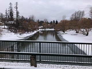
The Whitefish River is a 24.8-mile-long (39.9 km) southward-flowing stream originating at the outlet of Whitefish Lake. The river is a tributary of the Stillwater River just before it reaches the Flathead River in Flathead County, in the U.S. state of Montana. The Whitefish River is part of the Columbia River basin, as the Flathead River is a tributary of Clark Fork, which is tributary to the Pend Oreille River, which is tributary to the Columbia River.

The Swan Range is a mountain range in western Montana in the United States. Its peaks typically rise to around 8,000 to 9,000 feet. The range is bounded by the South Fork Flathead River to the east, the Flathead River to the north and northwest, the Swan River to the west, and lie to the southwest of Glacier National Park, just south of the Canada–US border. It runs about 99 miles (159 km) from north-northwest to south-southeast. Major cities near the Swan Range include Kalispell and Bigfork to the northeast, and Seeley Lake on the south.
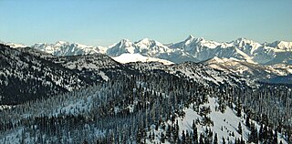
The Whitefish Range is a mountain range stretching north-south from British Columbia, Canada to Montana, United States. It is about 76 miles (122 km) long and 58 miles (93 km) wide. Water flowing from its east side drains down the North Fork Flathead River and its west side drains into the Whitefish River, both part of the Columbia River drainage basin.

Mount Calowahcan is sixth highest peak in the Mission Mountains and is located in northwestern Montana in the United States. East of the mountain is the Swan Valley and to the west side is the Mission Valley.

Whitefish Lake ; is a natural oligotrophic freshwater lake in Flathead County, Montana, United States.

Great Northern Mountain is a prominent 8,705-foot-elevation (2,653 meter) mountain summit located in Flathead County in the U.S. state of Montana. It is situated in the Flathead National Forest, in the Flathead Range, west of the Continental Divide. Great Northern Mountain is the highest point in the Great Bear Wilderness, and the nearest higher peak is Mount Saint Nicholas, 10.56 miles to the east-northeast in Glacier National Park. Topographic relief is significant as the west aspect rises 5,100 feet (1,555 meters) above Hungry Horse Reservoir in four miles, and the east aspect rises the same in five miles above the Middle Fork Flathead Valley. The Great Northern Railway is the namesake of the mountain, and the mountain is the namesake of the Great Northern Brewing Company.

Gable Peaks is a remote 7,700-foot (2,347-metre) double summit mountain located in Flathead County of the U.S. state of Montana.

Argosy Mountain is an 8,155-foot (2,486-metre) summit located in Flathead County of the U.S. state of Montana.

