Hurricane Joan–Miriam

Last updated

Map key
  Tropical depression (≤38 mph, ≤62 km/h)
  Tropical storm (39–73 mph, 63–118 km/h)
  Category 1 (74–95 mph, 119–153 km/h)
  Category 2 (96–110 mph, 154–177 km/h)
  Category 3 (111–129 mph, 178–208 km/h)
  Category 4 (130–156 mph, 209–251 km/h)
  Category 5 (≥157 mph, ≥252 km/h)
  Unknown
Storm type
Disc Plain black.svg Tropical cyclone
Solid black.svg Subtropical cyclone
ArrowUp.svg Extratropical cyclone, remnant low, tropical disturbance, or monsoon depression

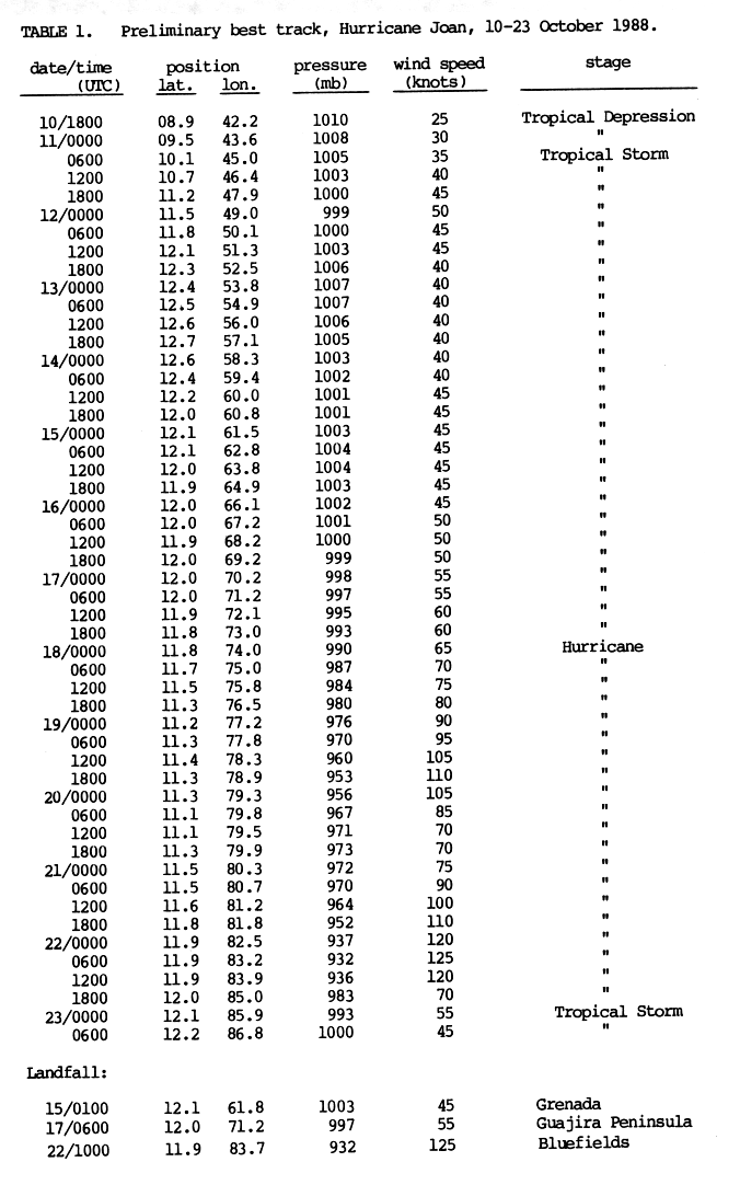
At the time, Joan was one of the latest tropical cyclones to form in the central Atlantic in any season. [4] It formed from an area of convection in the Intertropical Convergence Zone that moved off the coast of Africa early in October. It developed banding and was upgraded to Tropical Depression Seventeen on October 10 and later designated as Tropical Storm Joan while located at low latitude in the central Atlantic Ocean. [5]

Hurricane Joan off the Colombian coast on October 18 Joan 1988-10-18 1800Z.png
Hurricane Joan off the Colombian coast on October 18

Joan gradually strengthened as it passed over the southern Windward Islands on October 15. It continued heading west in response to a strong ridge, and passed over the Guajira Peninsula on October 17. [5] After entering the extreme southwestern Caribbean Sea, Joan strengthened into a hurricane. It then slowly executed a small counterclockwise loop, possibly in response to the nearby Tropical Depression Eighteen. [2] Upwelling caused by the quasi-stationary hurricane weakened the system. As the nearby depression dissipated, Joan resumed its westward track. A strong anticyclone over the southwestern Caribbean Sea created an extremely favorable environment, and Joan underwent rapid deepening at a rate of 38 millibars in the space of a day. [4] With a minimum pressure of 932 millibars, Joan was one of the strongest October hurricanes since 1961. [4] At the time, it was located at 12°N, the southernmost Category 4 hurricane ever recorded at the time. [5] That record has since been broken by Hurricane Ivan. [2] [6] [7]

Joan made landfall just south of Bluefields on October 22. [7] It passed over the northern portion of Lake Nicaragua, passed over Managua, and entered the Pacific Ocean near Leon on October 23. [2] Joan remained a hurricane or tropical storm during its entire passage over Central America, and was a minimal tropical storm when it reached the Pacific. [2] As per the policy at the time, Joan was renamed Miriam. [2]

Tropical Storm Miriam hugged the coast of Central America and reached its peak of 986 millibars on October 24. [8] Ordinarily, a pressure this low would indicate a Category 1 hurricane, but due to its disorganized convection, Miriam was not upgraded to a hurricane. [8] Land interaction and wind shear weakened Miriam to a tropical depression on October 26. Low-level winds carried the system out to sea, and its convection dissipated on October 28. [8]

Miriam's remnants continued out to sea, and they regenerated on October 30. The tropical depression hung on for the next few days, until its second, and final, dissipation on November 2. [9]

Unusual path

Hurricane Joan's path through the southern Caribbean in late October was highly unusual. Most October storms in the Atlantic gravitate towards the northern portion of the Caribbean, and often recurve quickly. [10] Joan took the southernmost path of an Atlantic-basin tropical cyclone in the Northern Hemisphere since a June system in 1933, although Hurricane Irene in 1971 took a path that was just north of Joan's. [5] Joan-Miriam was also unusual in that it survived the passage from the Atlantic to Pacific Ocean. Only thirteen other storms have been known to survive the crossover between the Atlantic and Pacific oceans. [11]

Preparations

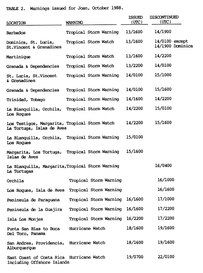
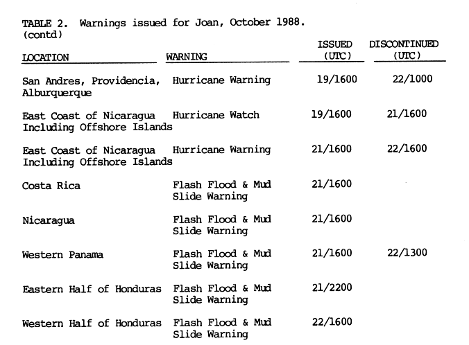
Tropical storm watches and later warnings were issued for the Windward Islands as far north as Martinique on October 13. They were dropped over the subsequent two days as Joan passed through. Along the coast of South America, additional warnings were raised and later dropped as Joan paralleled the coast. [12]

The first hurricane watches were issued for parts of Panama, and Providencia starting on October 18. The watch area was expanded to include Costa Rica and Nicaragua on October 19 as the watches were upgraded to warnings. These warnings provided several hours' worth of lead time, allowing evacuations and preparations to be made. [13] In addition, flash flood and mudslide warnings were issued for western Panama, Costa Rica, Honduras, and Nicaragua starting on October 21.

In response to Miriam, the flood and mudslide warnings issued because of Joan were not lifted until October 23 and 25. Tropical Storm warnings were issued for the Pacific coast of Nicaragua, El Salvador, and the Gulf of Fonseca on October 24. They were dropped the next day. Guatemala was placed under a warning on October 24. In addition, new flash flood and mudslide warnings were raised for Guatemala and the Mexican state of Chiapas on October 24 and 25, respectively. All warnings and watches were discontinued later on October 25 as Miriam turned away from the coast. [14]

Despite the dangers from the intense hurricane, evacuations in Bluefields were met with resistance and disbelief from residents. [3] In Managua, 70,000 people were evacuated to safe areas. [2] In the remaining areas of Nicaragua, 300,000 people were evacuated. [15] In Costa Rica, a total of 55,000 people were evacuated. [16]

Impact

Hurricane Joan–Miriam
Joan 1988-10-21 1930Z.png
Hurricane Joan near peak intensity on October 21 east of Costa Rica
Impact by Country
CountryDeathsDamage
Nicaragua 148-248$751.1 million
Costa Rica 28-46$60 million
Colombia 25$1 billion
Venezuela 11Unknown
Panama 7$60 million
Total216-337$1.85 billion

Hurricane Joan killed at least 216 people, with 118 unaccounted for. The total cost of damage was around $2 billion (1988 USD). [1] All of the deaths and most of the damage were due to the Joan portion of Hurricane Joan–Miriam. [9]

Lesser Antilles

No casualties were reported in the Windward Islands, including Grenada, where, on October 15, Joan made landfall. [3] Passing just south, Joan brought rough seas and winds of 40 mph (65 km/h) with gusts to 55 mph (90 km/h) to the islands of Aruba, Bonaire, and Curaçao on October 16, damaging coastal facilities and roofs. Structural damage from the storm was estimated at $1.5 million (1988 USD). Increased moisture in Joan's wake caused persistent rainfall on the islands for several days, leading to widespread flooding. [17] In Trinidad and Tobago, Joan was described as a "minor inconvenience". [18] Sustained winds up to 51 mph (82 km/h) with gusts up to 64 mph (103 km/h) were recorded on Grenada. Heavy rains amounted to 6 in (150 mm) in St. George's. Significant flooding was reported throughout the island, resulting in hundreds of thousands of dollars in damage. [19] A rare invasion of African desert locusts in the Windward Islands were blamed on the storm. [20]

Tropical Storm Joan shortly after passing over the Guajira Peninsula on October 17 Joan 1988-10-17 1600Z.png
Tropical Storm Joan shortly after passing over the Guajira Peninsula on October 17

South America

In Venezuela, 11 people were killed due to flash-flooding caused by heavy rains. Landslides and flooding killed 25 people in Colombia. The rains and flooding left 27,000 people homeless. [3] Throughout Colombia, damages amounted to $1 billion. [21]

Nicaragua

Most of the destruction was in Nicaragua. Throughout the country, 148 people perished, 184 were badly hurt, and 100 were unaccounted for. Roughly 23,300 homes were destroyed, with 6,000 being damaged. [2] Many settlements on the Atlantic coast of the country were completely destroyed. [15] The national electric company had 620 miles (1,000 km) of downed power lines, at the cost of 2.5 million USD (1988 dollars). [22] A port being constructed with Bulgarian help at El Bluff was severely damaged. On a brighter note, public health measures managed to keep the death toll lower than it could have been. [15]

Bluefields was hit with extreme impact. Almost all of the 7,500 structures in the city were demolished [19] or had their roofs blown off. The majority of the main buildings in the city were destroyed. [2] The hurricane also wreaked havoc on agriculture in the country. Around 15,700 head of cattle, 20,000 pigs, and 456,000 chickens were killed. [2] The hurricane caused severe disruption in most of Nicaragua's remaining rain forests in the areas it hit, and also stripped trees of leaves. [23] In the southeast rain forests, Joan toppled or snapped 80 percent of the trees and completely destroyed 500,000 hectares (1,200,000 acres) of canopy. [24] Hurricane Joan caused transportation difficulties in the country. Floodwaters destroyed 30 bridges and seriously damaged 36 others. Roads totaling 404 miles (650 km) in length were washed away. [2]

In an unfortunate coincidence, Hurricane Joan hit shortly after an armed conflict in the region had started to cool off. The hurricane destroyed much of the infrastructure in Nicaragua, contributing to a recession that was already underway. The losses to cash crops severely reduced exports to under 200 million dollars (1988 USD). [22] These factors combined to aggravate a recession and deepen the economic crisis. Government spending to rebuild infrastructure negated recently introduced anti-inflation measures. Hurricane Joan was a partial cause of Nicaraguans being, on average, worse-off than they were in the 1970s. [25] In all, the storm left at least 250,000 people homeless. [26] Total damages in the country amounted to $751.1 million. [21] Joan was the first major hurricane to strike Nicaragua since Edith in 1971.

Joan-Miriam's rainfall in Mexico Joan-Miriam 1988 rainfall.gif
Joan-Miriam's rainfall in Mexico

Rest of Central America

In Costa Rica, 28 people were killed, 75 were injured, and 18 were missing. Rainfall caused 20 rivers to burst their banks, flooding 75 settlements, including the city of Quepos, Costa Rica on the Pacific coast. At Ciudad Neily, Costa Rica, the Rio Corredores broke through a dike. In total, 7,500 Costa Ricans were rendered homeless. [3] Damages in Costa Rica amounted to $65 million. [27]

In the remaining portions of Central America, heavy rainfall, locally exceeding 300 millimetres (12 in), was reported. These rains caused flooding and landslides, especially in mountainous regions. [2] Those heavy rains caused seven deaths in Panama and left $60 million in damages. [28]

Mexico

In Mexico, heavy rainfall associated with Tropical Storm Miriam caused the cancellation of flights from the airport at Tuxtla Gutiérrez. The highest rainfall reported recorded was 10.37 inches (263 mm) at Lázaro Cárdenas. [29] In small settlements, rivers were flooded and mudslides were reported. Casualties from the flooding are not known. [9]

Aftermath

The response to requests for international aid was moderate. American church groups, Cuba, and Mexico collectively contributed around 2,500 tons of food and medicine. The Canadian, Swedish, West German, Spanish, and Dutch governments contributed aid amounting to 2 million dollars (1988) each. No aid was sent by the United States government. The Soviet Union contributed an unknown sum. [22] The slow response to requests for aid was contributed to by the Sandinista Government's actions, which was viewed by a few anonymous diplomats from other countries who commented to the press, as undermining the peace process championed by Óscar Arias. [22] Those actions were the July 10 arrests of opposition activists and the closing down of independent radio stations. [22] In addition, the government also barred foreign humanitarian groups from receiving American aid, as well as turning back a relief shipment days before the storm. [22]

On October 28, 1988, the United Nations General Assembly passed without a vote Resolution 17 of its 43rd session in response to the disaster. The resolution called on countries to contribute to the relief effort. [30]

Retirement

On account of the deaths and destruction caused by the hurricane in the Atlantic basin, the name "Joan" was retired by the World Meteorological Organization in the spring of 1989. The name "Miriam" was not retired. [31] "Joan" was replaced with "Joyce" for the 1994 Atlantic hurricane season. [32]

See also

Related Research Articles

<span class="mw-page-title-main">National Hurricane Center</span> Division of the United States National Weather Service

The National Hurricane Center (NHC) is the division of the United States' NOAA/National Weather Service responsible for tracking and predicting tropical weather systems between the Prime Meridian and the 140th meridian west poleward to the 30th parallel north in the northeast Pacific Ocean and the 31st parallel north in the northern Atlantic Ocean. The agency, which is co-located with the Miami branch of the National Weather Service, is situated on the campus of Florida International University in University Park, Miami, Florida.

<span class="mw-page-title-main">1988 Atlantic hurricane season</span> Hurricane season in the Atlantic Ocean

The 1988 Atlantic hurricane season was a near average season that proved costly and deadly, with 15 tropical cyclones directly affecting land. The season officially began on June 1, 1988, and lasted until November 30, 1988, although activity began on May 30 when a tropical depression developed in the Caribbean. The June through November dates conventionally delimit the period of each year when most tropical cyclones form in the Atlantic basin. The first cyclone to attain tropical storm status was Alberto on August 8, nearly a month later than usual. The final storm of the year, Tropical Storm Keith, became extratropical on November 24. The season produced 19 tropical depressions of which 12 attained tropical storm status. One tropical storm was operationally classified as a tropical depression but was reclassified in post-analysis. Five tropical cyclones reached hurricane status of which three became major hurricanes reaching Category 3 on the Saffir–Simpson scale.

<span class="mw-page-title-main">Hurricane Cesar–Douglas</span> Category 4 Atlantic and Pacific hurricane in 1996

Hurricane Cesar–Douglas was one of the few tropical cyclones to survive the crossover from the Atlantic to east Pacific basin, and was the last to receive a new storm name upon doing so. Hurricane Cesar was the third named storm and second hurricane of the 1996 Atlantic hurricane season. The system formed in the southern Caribbean Sea and affected several countries in South America before crossing Nicaragua and entering the Eastern Pacific where it was renamed Hurricane Douglas, the fourth named storm, third hurricane, and first and strongest major hurricane of the 1996 Pacific hurricane season. The storm killed 113 people in Central and South America and left 29 others missing, mainly due to flooding and mudslides.

<span class="mw-page-title-main">1988 Pacific hurricane season</span> Hurricane season in the Pacific Ocean

The 1988 Pacific hurricane season was the least active Pacific hurricane season since 1981. It officially began May 15, in the eastern Pacific, and June 1, in the central Pacific and lasted until November 30. These dates conventionally delimit the period of each year when most tropical cyclones form in the northeastern Pacific Ocean. The first named storm, Tropical Storm Aletta, formed on June 16, and the last-named storm, Tropical Storm Miriam, was previously named Hurricane Joan in the Atlantic Ocean before crossing Central America and re-emerging in the eastern Pacific; Miriam continued westward and dissipated on November 2.

<span class="mw-page-title-main">Hurricane Gert</span> Category 2 Atlantic and Pacific hurricane in 1993

Hurricane Gert was a large tropical cyclone that caused extensive flooding and mudslides throughout Central America and Mexico in September 1993. The seventh named storm and third hurricane of the annual hurricane season, Gert originated as a tropical depression from a tropical wave over the southwestern Caribbean Sea on September 14. The next day, the cyclone briefly attained tropical storm strength before moving ashore in Nicaragua and proceeding through Honduras. It reorganized into a tropical storm over the Gulf of Honduras on September 17, but weakened back to a depression upon crossing the Yucatán Peninsula. Once over the warm waters of the Bay of Campeche, Gert quickly strengthened into a Category 2 hurricane by September 20. The hurricane made a final landfall on the Gulf Coast of Mexico near Tuxpan, Veracruz, with peak winds of 100 mph (160 km/h). The rugged terrain disrupted the cyclone's structure; Gert entered the Pacific Ocean as a depression near the state of Nayarit on September 21, where it briefly redeveloped a few strong thunderstorms before dissipating at sea five days later.

<span class="mw-page-title-main">Hurricane Debby (1988)</span> Category 1 Atlantic and Pacific hurricane in 1988

Hurricane Debby was the first hurricane to strike the Mexican state of Veracruz since Hurricane Anna in 1956. The eighth tropical cyclone, fourth named storm, and the first hurricane of the 1988 Atlantic hurricane season, Debby developed from a tropical wave off the west coast of the Yucatan Peninsula on August 31. The system slowly intensified as it tracked west-northwestward toward Mexico, eventually reaching tropical storm status on September 2. Thereafter, Debby began to rapidly strengthen, and the storm was upgraded to a hurricane later that day. After attaining peak winds of 75 mph (120 km/h), Debby made landfall near Tuxpan, Veracruz early on September 3. The hurricane quickly weakened inland, but managed to reach the eastern Pacific on September 5. Debby became Tropical Depression Seventeen-E, which moved northwest but remained poorly organized due to wind shear and dissipated on September 8.

<span class="mw-page-title-main">1987 Gulf Coast tropical storm</span> Atlantic tropical storm in 1987

The 1987 Gulf Coast tropical storm caused flooding along the Gulf Coast of the United States. The second tropical cyclone and first tropical storm of the 1987 Atlantic hurricane season, it originated from a tropical wave in the Gulf of Mexico, southeast of Texas, on August 9. Initially a tropical depression, the cyclone moved north-northwestward and slightly intensified into a tropical storm later that day. By August 10, it made landfall between Galveston and Beaumont. The system weakened after moving inland and turned towards the east and later southeast. Briefly reemerging over the Gulf on August 15, the depression moved onshore a second time in Florida, before dissipating over eastern Georgia on August 17.

<span class="mw-page-title-main">Tropical Storm Alma</span> Pacific tropical storm in 2008

Tropical Storm Alma of the 2008 Pacific hurricane season was the easternmost forming Pacific tropical cyclone on record. It formed within the monsoon trough just off the coast of Costa Rica on May 29. Initially forecast to remain a weak tropical storm, the cyclone rapidly strengthened and developed an eye, before making landfall on May 29 in Nicaragua, near León, with peak winds of 65 mph (105 km/h). Alma degenerated into a remnant low on May 30, before merging with another approaching tropical wave in the Gulf of Honduras shortly afterward, which became Tropical Storm Arthur on the next day. Alma was the first tropical storm on record to strike the Pacific coast of Nicaragua. In Costa Rica, heavy rainfall caused flooding and landslides, killing two and causing $35 million (USD) in damage. Three people were killed in Nicaragua, one from drowning and two others from electrocution. Five others died in Honduras from an aviation accident likely related to the storm and one other was swept away in floodwaters.

<span class="mw-page-title-main">Hurricane Irene–Olivia</span> Category 3 Atlantic and Pacific hurricane in 1971

Hurricane Irene–Olivia was the first actively tracked tropical cyclone to move into the eastern Pacific Ocean from the Atlantic basin. It originated as a tropical depression on September 11, 1971, in the tropical Atlantic. The cyclone tracked nearly due westward at a low latitude, passing through the southern Windward Islands and later over northern South America. In the southwest Caribbean Sea, it intensified to a tropical storm and later a hurricane. Irene made landfall on southeastern Nicaragua on September 19, and maintained its circulation as it crossed the low-lying terrain of the country. Restrengthening after reaching the Pacific, Irene was renamed Hurricane Olivia, which ultimately attained peak winds of 115 mph (185 km/h). Olivia weakened significantly before moving ashore on the Baja California Peninsula on September 30; the next day it dissipated.

<span class="mw-page-title-main">Hurricane Ida (2009)</span> Category 2 Atlantic hurricane in 2009

Hurricane Ida was the strongest landfalling tropical cyclone during the 2009 Atlantic hurricane season, crossing the coastline of Nicaragua with winds of 80 mph (130 km/h). The remnants of the storm became a powerful nor'easter that caused widespread damage along coastal areas of the Mid-Atlantic States. Ida formed on November 4 in the southwestern Caribbean, and within 24 hours struck the Nicaragua coast with winds of 80 mph (130 km/h). It weakened significantly over land, although it restrengthened in the Yucatán Channel to peak winds of 105 mph (170 km/h). Hurricane Ida weakened and became an extratropical cyclone in the northern Gulf of Mexico, before spreading across the southeastern United States. The remnants of Ida contributed to the formation of a nor'easter that significantly affected the eastern coast of the United States.

<span class="mw-page-title-main">Tropical Storm Agatha (1992)</span> Pacific tropical storm in 1992

Tropical Storm Agatha was the deadliest tropical cyclone to form during the 1992 Pacific hurricane season, killing 10 people as it passed offshore Mexico. The third named storm of the record-breaking season, Agatha developed as a tropical depression off the Pacific coast of Mexico on June 1. The storm gradually organized over the next several hours. As it moved northward, the depression intensified into Tropical Storm Agatha later that day. After reaching its peak winds as a strong tropical storm, Agatha steadily weakened while turning to the west. The system was downgraded to a tropical depression on June 5, and subsequently lost its tropical characteristics the next day. Although Agatha never made landfall, the storm's outer rainbands triggered widespread flooding that killed ten people.

<span class="mw-page-title-main">Hurricane Otto</span> Category 3 Atlantic and Pacific hurricane in 2016

Hurricane Otto was a strong late-season tropical cyclone that impacted parts of Central America in November 2016. It was the first Atlantic hurricane since Cesar–Douglas in 1996 to survive the crossover from the Atlantic Ocean to the Pacific Ocean. Forming late on November 20 in the southwestern Caribbean Sea, Otto was the fifteenth and final named storm, seventh hurricane and fourth major hurricane of the 2016 Atlantic hurricane season. It quickly intensified into a strong tropical storm the next day, and on November 23–24, rapidly strengthened into a Category 3 hurricane, the first in the month of November since Hurricane Paloma in 2008, and the latest date an Atlantic hurricane attained such intensity on record. Otto made landfall in Nicaragua at peak intensity on November 24, thus becoming the latest hurricane to make landfall in the Atlantic basin since 1851 when records began. Traveling along the Nicaragua–Costa Rica border, the system rapidly weakened to a tropical storm before emerging over the eastern Pacific Ocean, becoming the final storm of the 2016 Pacific hurricane season as well. Hostile environmental conditions inhibited reorganization, and Otto subsequently degenerated into an elongated trough on November 26.

<span class="mw-page-title-main">Hurricane Nate</span> Category 1 Atlantic hurricane in 2017

Hurricane Nate was an Atlantic hurricane which was the costliest natural disaster in Costa Rican history. An unusually fast-moving tropical cyclone, it caused severe flooding in Central America, leading to widespread destruction and casualties, during early October 2017, before making landfall on the US Gulf Coast. The fourteenth named storm and ninth hurricane of the extremely active 2017 Atlantic hurricane season, Nate originated from a broad area of low pressure over the southwestern Caribbean on October 3. The disturbance moved northwest, organizing into a tropical depression the next day and attaining tropical storm intensity early on October 5. The storm made landfall in Nicaragua that same day and continued into Honduras with little change in strength. Nate began steady intensification over the warm waters of the northwestern Caribbean Sea shortly thereafter. It attained hurricane strength while moving through the Yucatán Channel early on October 7, attaining peak winds of 90 mph (150 km/h) in the central Gulf of Mexico later that day. Early on the next day, Nate made landfall near the mouth of the Mississippi River in Louisiana. After crossing the marshland of the Mississippi Delta, it made its second U.S. landfall near Biloxi, Mississippi early on October 8, causing a storm surge to flood the ground floors of coastal casinos and buildings, as well as causing rip currents, hurricane-force winds, and beach erosion.

<span class="mw-page-title-main">Tropical Storm Selma (2017)</span> Pacific tropical storm in 2017

Tropical Storm Selma was the first tropical storm on record to make landfall in El Salvador, and only the second Pacific tropical cyclone to attain tropical storm strength east of 90°W, the other being Alma of 2008. The twentieth tropical cyclone and eighteenth named storm of the 2017 Pacific hurricane season, Selma formed from a Central American gyre on October 27. The storm tracked northeastward and reached its peak intensity as a minimal tropical storm before making landfall east of San Salvador, El Salvador early on October 28. Selma rapidly weakened after making landfall, and its remnant circulation dissipated overland at 18:00 UTC on the same day.

<span class="mw-page-title-main">Tropical cyclone effects by region</span> Tropical cyclone effects and impacts

Tropical cyclones regularly affect the coastlines of most of Earth's major bodies of water along the Atlantic, Pacific, and Indian oceans. Also known as hurricanes, typhoons, or other names, tropical cyclones have caused significant destruction and loss of human life, resulting in about 2 million deaths since the 19th century. Powerful cyclones that make landfall – moving from the ocean to over land – are some of the most impactful, although that is not always the case. An average of 86 tropical cyclones of tropical storm intensity form annually worldwide, with 47 reaching hurricane/typhoon strength, and 20 becoming intense tropical cyclones, super typhoons, or major hurricanes.

<span class="mw-page-title-main">Hurricanes in Costa Rica</span>

Costa Rica, officially the Republic of Costa Rica, is a country in Central America, bordered by Nicaragua to the north, the Caribbean to the northeast, Panama to the southeast, the Pacific Ocean to the southwest, and Ecuador to the south of Cocos Island. It has a population of around 5 million in a land area of 51,060 square kilometers. Hurricanes are uncommon in the country, as only eighteen have been recorded in history.

<span class="mw-page-title-main">Hurricanes in Nicaragua</span>

Nicaragua, officially the Republic of Nicaragua, is the largest country in the Central American isthmus, bordered by Honduras to the northwest, the Caribbean to the east, Costa Rica to the south, and the Pacific Ocean to the southwest. Tropical cyclones are common in the country, with an average of one storm a year. The coast is especially subject to destructive tropical storms and hurricanes, particularly from July through October. The high winds and floods, accompanying these storms often cause considerable destruction of property. Hurricanes or heavy rains in the central highlands where agriculture has destroyed much of the natural vegetation also cause considerable crop damage and soil erosion. One of the deadliest hurricanes to hit Nicaragua has been Hurricane Mitch in 1998, in which the storm killed thousands in the country.

<span class="mw-page-title-main">Hurricane Bonnie (2022)</span> Category 3 Atlantic and Pacific hurricane in 2022

Hurricane Bonnie was a strong tropical cyclone that survived the crossover from the Atlantic Ocean to the Pacific Ocean, the first to do so since Hurricane Otto in 2016. The second named storm of the 2022 Atlantic hurricane season, it originated from a strong tropical wave that moved off the west coast of Africa on June 23. Moving with little development despite favorable conditions, the National Hurricane Center (NHC) started advisories on it as Potential Tropical Cyclone Two late on June 27, due to its imminent threat to land. The disturbance finally organized into Tropical Storm Bonnie at 13:15 UTC on July 1, and made brief landfalls on the Costa Rica–Nicaragua border with winds of 50 miles per hour (80 km/h). It later became the fourth named storm, third hurricane, and first major hurricane of the 2022 Pacific hurricane season after crossing Nicaragua and Costa Rica from east to west on July 2 and intensifying to a Category 3 hurricane on July 5. Bonnie rapidly weakened, dissipating over the North Pacific.

<span class="mw-page-title-main">Hurricane Julia (2022)</span> Category 1 Atlantic and Pacific hurricane in 2022

Hurricane Julia was a deadly tropical cyclone that caused significant impacts in Central America as a Category 1 hurricane in October 2022. The tenth named storm and fifth hurricane of the 2022 Atlantic hurricane season, Julia formed from a tropical wave over the southern Caribbean Sea on October 7, just off the coast of South America. Only one storm on record, Tropical Storm Bret in 1993, has tracked further south over South America.

References

  1. 1 2 Miles B. Lawrence; James M. Gross (October 1989). "Annual Summaries: Atlantic Hurricane Season of 1988" (PDF). Monthly Weather Review . 117 (10): 2248–2259. Bibcode:1989MWRv..117.2248L. doi:10.1175/1520-0493(1989)117<2248:AHSO>2.0.CO;2. Archived from the original (PDF) on February 14, 2012. Retrieved April 9, 2006.
  2. 1 2 3 4 5 6 7 8 9 10 11 12 Dr. Harold P. Gerrish. NHC Joan report p. 2 accessed April 10, 2006. Archived from the original on July 25, 2020.
  3. 1 2 3 4 5 Harold P. Gerrish. "NHC Joan report p. 3" . Retrieved April 10, 2006.
  4. 1 2 3 Padgett, Gary. "Monthly Global Tropical Cyclone Summary for October 2003 Part 1". Archived from the original on September 28, 2007. Retrieved April 10, 2006.
  5. 1 2 3 4 Harold P. Gerrish. "NHC Joan report p. 1" . Retrieved April 10, 2006.
  6. Stacey R. Stewart. "NHC Ivan Report". Archived from the original on April 14, 2006. Retrieved April 27, 2006.
  7. 1 2 Harold P. Gerrish. "NHC Joan report p. 7" . Retrieved April 10, 2006.
  8. 1 2 3 Dr. Harold P. Gerrish. NHC Miriam report p. 1 accessed April 10, 2006
  9. 1 2 3 Dr. Harold P. Gerrish. NHC Miriam report p. 2 accessed April 10, 2006
  10. National Hurricane Center. NHC Tropical Cyclone Climatology Archived December 13, 2007, at the Wayback Machine accessed April 10, 2006
  11. Stephen Caparotta, D. Walston, Steven Young and Gary Padgett. NHC Tropical Cyclone FAQ Subject E15 accessed April 10, 2006
  12. Dr. Harold P. Gerrish. NHC Joan report p. 8 accessed April 10, 2006
  13. Dr. Harold P. Gerrish. NHC Joan report p. 9 accessed April 10, 2006
  14. Dr. Harold P. Gerrish. NHC Miriam report p. 4 accessed April 10, 2006
  15. 1 2 3 Fox, Robert Nicaragua Still Reeling in Wake of a Hurricane Archived March 20, 2005, at the Wayback Machine accessed April 10, 2006
  16. "NHC Joan report p. 4" . Retrieved April 10, 2006.
  17. "Hurricane Climatology of the Netherlands Antilles and Aruba" (PDF). Hurricanes and Tropical Storms in the Netherlands Antilles and Aruba (Report). Meteorological Service of the Netherlands Antilles and Aruba. April 2010. p. 18. Archived from the original (PDF) on April 2, 2012.
  18. Trinidad and Tobago Meteorological Service, Tropical Cyclones Affecting Trinidad and Tobago, 1725 to 2000 Archived May 23, 2005, at the Wayback Machine p 14. Accessed February 18, 2007
  19. 1 2 David Longshore Encyclopedia of Hurricanes, Typhoons, and Cyclones pg. 203
  20. C. Howard Richardson; David J. Nemeth (April 1991). "Hurricane-borne African Locusts (Schistocerca gregaria) on the Windward Islands". GeoJournal. 23 (4). doi:10.1007/BF00193608. ISSN   0343-2521. S2CID   189889893.
  21. 1 2 United Nations Department of Humanitarian Affairs (1988). "Hurricane Joan — Oct 1988 UN DHA Situation Reports 1-13". ReliefWeb. Retrieved August 26, 2009.[ dead link ]
  22. 1 2 3 4 5 6 Preston, Julia, Washington Post (1988) Response Tepid to Managua's Aid Plea accessed April 10, 2006
  23. Vetiver Network International. Vetiver as a Component of World Relief's Sustainable Agriculture Program in Nicaragua accessed April 11, 2006
  24. Katherine Yih; Douglas h. Boucher; John H. Vandermeer; Nelson Zamora (1991). "Recovery of the Rain Forest of Southeastern Nicaragua After Destruction by Hurricane Joan" (PDF). Biotropica. 23 (2): 106–113. doi:10.2307/2388295. JSTOR   2388295 . Retrieved November 7, 2009.
  25. United States Library of Congress. Nicaragua Historical Background accessed April 11, 2006
  26. David Longshore Encyclopedia of Hurricanes, Typhoons, and Cyclones pg. 204
  27. McLean (December 19, 1988). "Natural disasters took record tolls this year". USAToday. Retrieved August 26, 2009.
  28. "Primer on Natural Hazard Management in Integrated Regional Development Planning chpt. 12" (PDF). Washington, D.C.: Organization of American States. 1991. Archived (PDF) from the original on February 16, 2021. Retrieved February 16, 2021.{{cite journal}}: Cite journal requires |journal= (help)
  29. Hydrometeorological Prediction Center. Hurricane Joan-Miriam. Retrieved on 2007-01-31.
  30. United Nations General Assembly Resolution 43/17: Emergency assistance to Nicaragua, Costa Rica, Panama and other countries affected by hurricane (sic) Joan accessed April 11, 2006
  31. "Tropical Cyclone Naming History and Retired Names". Miami, Florida: National Hurricane Center. Retrieved April 5, 2024.
  32. National Hurricane Operations Plan (PDF) (Report). Washington, D.C.: NOAA Office of the Federal Coordinator for Meteorological Services and Supporting Research. May 1994. p. 3-7. Retrieved April 5, 2024.