
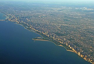
Lakeview, also spelled Lake View, is one of the 77 community areas of Chicago, Illinois. Lakeview is located in the city's North Side. It is bordered by West Diversey Parkway on the south, West Irving Park Road on the north, North Ravenswood Avenue on the west, and the shore of Lake Michigan on the east. The Uptown community area is to Lakeview's north, Lincoln Square to its northwest, North Center to its west, and Lincoln Park to its south. The 2020 population of Lakeview was 103,050 residents, making it the second-largest Chicago community area by population.
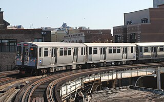
The Red Line is a rapid transit line in Chicago, run by the Chicago Transit Authority (CTA) as part of the Chicago "L" system. It is the busiest line on the "L" system, with an average of 93,457 passengers boarding each weekday in 2022. The route is 26 miles (42 km) long with a total of 33 stations. It runs elevated from the Howard station in the Rogers Park neighborhood on the North Side, through a subway on the Near North Side, Downtown, and the South Loop, and then through the Dan Ryan Expressway median to 95th/Dan Ryan in the Roseland neighborhood on the South Side.
Lincoln Park is a 1,208-acre (489-hectare) park along Lake Michigan on the North Side of Chicago, Illinois. Named after US President Abraham Lincoln, it is the city's largest public park and stretches for seven miles (11 km) from Grand Avenue, on the south, to near Ardmore Avenue on the north, just north of the DuSable Lake Shore Drive terminus at Hollywood Avenue. Two museums and a zoo are located in the oldest part of the park between North Avenue and Diversey Parkway in the eponymous neighborhood. Further to the north, the park is characterized by parkland, beaches, recreational areas, nature reserves, and harbors. To the south, there is a more narrow strip of beaches east of Lake Shore Drive, almost to downtown. With 20 million visitors per year, Lincoln Park is the second-most-visited city park in the United States, behind Central Park.

The Near South Side is a community area of Chicago, Illinois, United States, just south of the downtown central business district, the Loop. The Near South Side's boundaries are as follows: North—Roosevelt Road ; South—26th Street; West—Chicago River between Roosevelt and 18th Street, Clark Street between 18th Street and Cermak Road, Federal between Cermak Road and the Stevenson Expressway just south of 25th Street, and Clark Street again between the Stevenson and 26th Street; and East—Lake Michigan.

Lower West Side is a community area on the West Side of Chicago, Illinois, United States. It is three miles southwest of the Chicago Loop and its main neighborhood is Pilsen. The Heart of Chicago is a neighborhood in the southwest corner of the Lower West Side.

Chatham is one of the 77 community areas of the city of Chicago, Illinois. It is located on the city's South Side. It includes the neighborhoods of Chatham-Avalon, Chatham Club, Chesterfield, East Chatham, West Chatham and the northern portion of West Chesterfield. Its residents are predominantly African American, and it is home to former Senator Roland Burris. Housing many city employees and other officials, Chatham has been a central area for Chicago's middle-class African Americans since the late 1950s.

The Magnificent Mile, sometimes referred to as The Mag Mile, is an upscale section of Chicago's Michigan Avenue, running from the Chicago River to Oak Street in the Near North Side. The district is located within downtown and one block east of Rush Street. The Magnificent Mile serves as the main thoroughfare between Chicago's Loop business district and its Gold Coast. It is generally the western boundary of the Streeterville neighborhood, to its east, and of River North to the west.

Halsted Street is a major north-south street in the U.S. city of Chicago, Illinois.
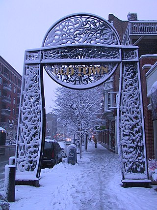
Old Town is a neighborhood and historic district in Near North Side and Lincoln Park, Chicago, Illinois, home to many of Chicago's older, Victorian-era buildings, including St. Michael's Church, one of seven buildings to survive the Great Chicago Fire.

Clark Street is a north–south street in Chicago, Illinois that runs close to the shore of Lake Michigan from the northern city boundary with Evanston, to 2200 South in the city street numbering system. At its northern end, Clark Street is at 1800 West; however the street runs diagonally through the Chicago grid for about 8 miles (13 km) to North Avenue and then runs at 100 West for the rest of its course south to Cermak Road. It is also seen in Riverdale beyond 127th street across the Calumet River, along with other nearby streets that ended just south of the Loop. The major length of Clark Street runs a total of 98 blocks.

Cermak Road, also known as 22nd Street, is a 19-mile, major east–west street on Chicago's near south and west sides and the city's western suburbs. In Chicago's street numbering system, Cermak is 2200 south, or twenty-two blocks south of the baseline of Madison Street. Normally, one mile comprises eight Chicago blocks, but the arterial streets Roosevelt Road, formerly named Twelfth Street and at 1200 South, and Cermak Road were platted before the eight-blocks-per-mile plan was implemented. Roosevelt Road is one mile south of Madison Avenue and there are twelve blocks within that mile. Cermak Road is two miles south of Madison Avenue and there are ten blocks within the mile between Roosevelt and Cermak Roads.
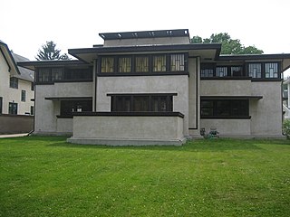
The Frank Lloyd Wright/Prairie School of Architecture Historic District is a residential neighborhood in the Cook County, Illinois village of Oak Park, United States. The Frank Lloyd Wright Historic District is both a federally designated historic district listed on the U.S. National Register of Historic Places and a local historic district within the village of Oak Park. The districts have differing boundaries and contributing properties, over 20 of which were designed by Frank Lloyd Wright, widely regarded as the greatest American architect.
There are 96 sites in the National Register of Historic Places listings in North Side Chicago — of more than 350 listings within the City of Chicago, in Cook County, Illinois.
Hyde Park–Kenwood Historic District is the name of the National Register of Historic Places (NRHP) district on the South Side of Chicago that includes parts of the Hyde Park and Kenwood community areas of Chicago, Illinois. The northern part of this district overlaps with the officially designated Chicago Landmark Kenwood District. This northern part of the Hyde Park–Kenwood Historic District contains the Chicago home of Barack Obama. The entire district was added to the NRHP on February 14, 1979, and expanded on August 16, 1984, and May 16, 1986. The district is bounded to the north, south, east and west, respectively by 47th Street, 59th Street, Lake Park Avenue and Cottage Groves Avenue. Despite the large amount of property associated with the University of Chicago, the Hyde Park–Kenwood Historic District is mostly residential. The district is considered to be significant for its architecture and education.

The Ann Halsted House is a house located at 440 W. Belden Street in the Lincoln Park community area of Chicago, Illinois. Designed in 1883 and built by 1884, the house is the oldest surviving residence designed by Dankmar Adler and Louis Sullivan. The brick house is designed in the Queen Anne style, which can be seen in its pointed bay windows and the detailed brickwork on the cornices and chimneys on the sides of the house; however, the front of the home reflects a French influence. Sullivan's influence on the home's exterior can mainly be seen in the dormers at the front and back and in the pediments on the sides. The fireplace and railings inside the house are also Queen Anne style, though they too reflect early traces of Sullivan's characteristic design.

Delaware Avenue Historic District is a national historic district located at Wilmington, New Castle County, Delaware. It encompasses 180 contributing buildings and 1 contributing structure developed in the late-19th and early-20th centuries. The district is primarily residential and includes a variety of Victorian-era mansions and large dwellings in a variety of popular architectural styles including Italianate, Queen Anne, Colonial Revival, Classical Revival, and American Four Square The houses are detached or semi-detached and are primarily three stories in height with extensive wings to the rear. The district also includes 20th century apartment complexes. Also located in the district is the St. Stephen's Lutheran Church and the Sailors and Soldiers Monument. The separately listed Howard Pyle Studios are also located in the district.
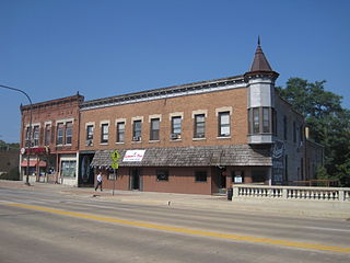
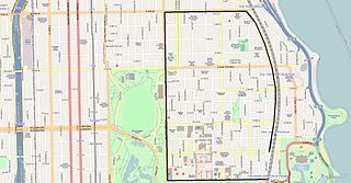
The Belvidere North State Street Historic District is a historic district on the north side of the Kishwaukee River in Belvidere, Illinois. It is primarily composed of commercial building representative of architectural trends from 1865 to 1962. The district has remained largely intact since the mid-1930s.
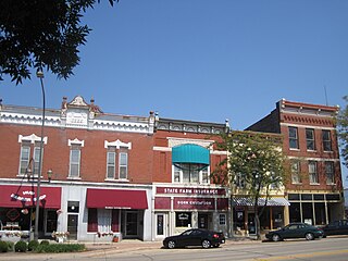
The Belvidere South State Street Historic District is a historic district on the north side of the Kishwaukee River in Belvidere, Illinois. It is primarily composed of commercial building representative of architectural trends from 1852 to 1962, the period following the connection of the city to the Galena and Chicago Union Railroad.

The Hermosa Bungalow Historic District is a historic district on the National Register of Historic Places in the Hermosa community area on the northwest side of Chicago. The district is roughly bounded by W. Belmont Avenue to the north, N. Lowell Avenue to the east, W. Diversey Avenue to the south, and N. Kolmar Avenue to the west. The district's contributing properties include 298 bungalows, 15 brick multi-unit apartment buildings, 8 brick two-flats, 3 garages, and Barry Elementary School.
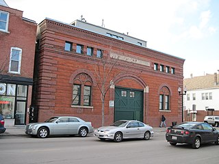
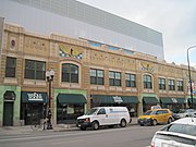
The Mandel Brothers Warehouse Building is a historic warehouse at 3254 N. Halsted Street in the Lakeview neighborhood of Chicago, Illinois. The Mandel Brothers Department Store, one of the oldest department store companies in Chicago at the time, built the warehouse in 1903 to support its delivery service. Prominent Chicago architecture firm Holabird & Roche, who also designed both stores and warehouses for many of Chicago's other department store companies, designed the warehouse. The firm used a Renaissance Revival design for the warehouse, an uncommon choice that stood out from Chicago's many utilitarian warehouses. Their design features a brick exterior with quoins, an arched entrance and windows, and a parapet with decorative brickwork.
 3640 N. Halsted Street
 Mandel Brothers Warehouse Building
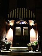 Entrance to 737 W. Belmont Avenue


