Related Research Articles
Comber is a town in County Down, Northern Ireland. It lies 5 miles (8 km) south of Newtownards, at the northern end of Strangford Lough. It is situated in the townland of Town Parks, the civil parish of Comber and the historic barony of Castlereagh Lower. Comber is part of the Ards and North Down Borough. It is also known for Comber Whiskey which was last distilled in 1953. A notable native was Thomas Andrews, the designer of the RMS Titanic and was among the many who went down with her. Comber had a population of 9,071 people in the 2011 Census.

Armagh is the county town of County Armagh and a city in Northern Ireland, as well as a civil parish. It is the ecclesiastical capital of Ireland – the seat of the Archbishops of Armagh, the Primates of All Ireland for both the Roman Catholic Church and the Church of Ireland. In ancient times, nearby Navan Fort was a pagan ceremonial site and one of the great royal capitals of Gaelic Ireland. Today, Armagh is home to two cathedrals and the Armagh Observatory, and is known for its Georgian architecture.

Newtownabbey is a large settlement north of Belfast city centre in County Antrim, Northern Ireland. It is separated from the rest of the city by Cavehill and Fortwilliam golf course, but it still forms part of the Belfast metropolitan area. It surrounds Carnmoney Hill, and was formed from the merging of several small villages including Whiteabbey, Glengormley and Carnmoney. At the 2021 census, Metropolitan Newtownabbey Settlement had a population of 67,599, making it the third largest settlement in Northern Ireland and seventh on the Island of Ireland. It is part of Antrim and Newtownabbey Borough Council.

Knocknaheeny is an electoral division and suburb in Cork city, Ireland. Just over 2 km from the city centre, it is located north of the River Lee on hills overlooking the city. It is a mainly residential area, and contains a number of terraced council housing estates. Apple's headquarters for Europe is located here and employs about 5,000 people.

Edenderry is a small village and townland in County Down, Northern Ireland. It lies on the bank of the River Lagan near the southern edge of Belfast. In the 2001 Census it had a population of 252. Its main source of employment for its people is work in nearby towns and cities, such as Belfast.

Upper Ballinderry is a small village to the east of Lower Ballinderry in County Antrim, Northern Ireland. It is within the townland of Ballyscolly and civil parish of Ballinderry, the historic barony of Massereene Upper. Upper Ballinderry is about 10 miles (15 km) north- west of Lisburn. In the 2001 Census it had a population of 192 people.

Edenderry is a small village and townland in County Tyrone, Northern Ireland. In the 2001 Census it had a population of 84. It is within the Fermanagh and Omagh District Council area and lies on the north bank of the Camowen River. The townland is traversed by the B158 road.
Ballinderry is a small civil and ecclesiastical parish on both sides of the County Londonderry / County Tyrone border in Northern Ireland. It is a rural parish of about 350 houses and lies on the western shores of Lough Neagh.
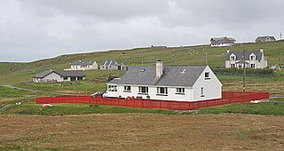
Timsgarry is a village on the Isle of Lewis, in the Outer Hebrides, Scotland. Timsgarry is home to the Baile na Cille Church and the Uig Museum, noted for its giant Chessmen, discovered in the sands in 1831.

Muintir Murchada was the name of an Irish territory which derived its name from the ruling dynasty, who were in turn a branch of the Uí Briúin. The name was derived from Murchadh mac Maenach, King of Uí Briúin Seóla, who died 891.
Bangor is a civil and ecclesiastical parish in County Down, Northern Ireland. It is located in the north of the Ards Peninsula, consisting of 30 townlands, twenty-two and a half of which lie in the barony of Ards Lower, with seven and a half lying within that of Castlereagh Lower. Its ancient monastery was of ecclesiastical importance.
Derryloughan is a townland in County Tyrone, Northern Ireland. It lies on the southwest corner of Lough Neagh, 4 miles from Coalisland. It is situated in the historic barony of Dungannon Middle and the civil parish of Clonoe and covers an area of 1751 acres.

Gaeltacht na nDéise is a Gaeltacht area in County Waterford consisting of the areas of Ring and Old Parish. It is located 10 km from the town of Dungarvan. Gaeltacht na nDéise has a population of 1,816 people and encompasses a geographical area of 62 km2. This represents 1% of total Gaeltacht area.
Glór na nGael is an Irish-language lead organisation funded by Foras na Gaeilge which promotes and supports Irish in three sectors: the family, community development, and business. It was established as an Irish language community group competition in 1961, and Cardinal Tomás Ó Fiaich and Monsignor Pádraig Ó Fiannachta were among its founders.

Dundalk Lower is a barony in County Louth, Ireland.
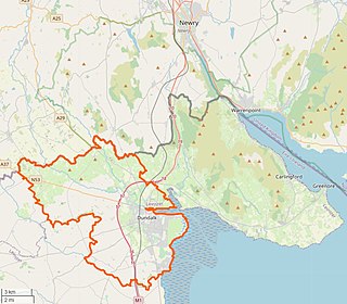
Dundalk Upper is a barony in County Louth, Ireland.

Ballycowan or Ballycowen is a barony in County Offaly, Ireland.
Derryconnessy is a townland in the civil parish of Templeport, County Cavan, Ireland. It lies in the Roman Catholic parish of Corlough and barony of Tullyhaw.
References
- ↑ "Heritage and Place Names". Colin Glen Trust. 2010. Retrieved 15 August 2010.
- Ordnance Survey Ireland – Online map viewer (choose 'historic' to see townland boundaries)
- Placenames NI

