National Register of Historic Places listings in Bayfield County, Wisconsin
Last updated
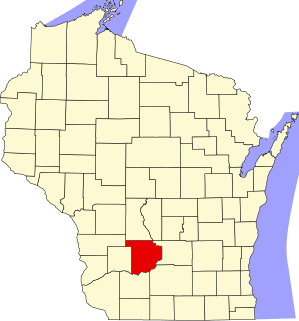
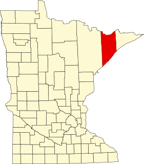
Location of Bayfield County in Wisconsin
This is a list of the National Register of Historic Places listings in Bayfield County, Wisconsin. It is intended to provide a comprehensive listing of entries in the National Register of Historic Places that are located in Bayfield County, Wisconsin. The locations of National Register properties for which the latitude and longitude coordinates are included below may be seen in a map.[1]
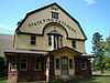
Monumental building designed by Conover and Porter in Romanesque style and built in 1890, of brownstone quarried north of Washburn. Now houses historical museum and cultural center.[7]
R. D. Pike operated a private fish hatchery on this site from the 1860s to 1895, when he donated the land to the state. The state built a new hatchery, with the gambrel-roofed Victorian building holding an office, living quarters, and a fish egg propagation area washed by the waters of Birch Run Creek.[9]
A 60-block area in the city of Bayfield,[10] encompassing commercial buildings from wooden false front to brownstone, and residences from modest to Queen Anne.[11]
Built as a fish storehouse around 1900, partly on cribbing. In 1914, Booth Fisheries converted part of the building to a factory in which five coopers hand-made wooden barrels - up to 75,000 a year - for packing locally caught salted fish.[11]
The chapel was built in 1870, the first Episcopal church in northern Wisconsin.[11] The whole is in Carpenter Gothic style, with board and batten exterior.[12]
Rustic retreat of the Livingston/Griggs family of St. Paul on Namekagon Lake, on the site of a logging camp. Buildings constructed from 1893 to 1950 include the lodge, two-story boathouse, and maid's cabin.[15]
St. Paul socialite Mary Livingston Griggs built this Rustic log building in 1925-26 for the community of Cable, in honor of her mother and their family lodge on Namekagon Lake.[16]
Dock built on crib piers in 1927 by the three Hokensen brothers, who ran an independent fishing boat and packing operation out of Sand Island from the 1920s to the 1950s.[18]
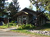
Rustic log cabin built in 1888,[19] summer retreat of the McCormick family and Dr. William Gray, newspaperman and editor of "The Interior," a Presbyterian publication.[20]
151-foot tugboat built in Chicago in 1881 that first towed rafts of logs across Lake Michigan. In November 1909, after helping free a grounded steamship, she mysteriously caught fire in the night, burned and sank.[21]
Tuberculosissanatorium, built from 1918 to 1923 before antibiotics, when TB was called consumption and treatment consisted of isolation, rest, and fresh air. Also called the Tri-County Sanatorium because it was shared by Bayfield, Ashland and Iron counties.[23]
Francis Shaw received land on Sand Island for his Civil War service and built a cabin in 1871, the first permanent home on the island. For 50 years he and the next generation fished and farmed, and later ran a workshop and a store, serving as the social center of the island.[26]
Group of historic buildings on Sand Island: Shaw Hill farm, an early fishing camp and farm; Camp Stella resort; and the Campbell-Jensch summer cottage.[27]
This is a list of the National Register of Historic Places listings in Sauk County, Wisconsin. It is intended to provide a comprehensive listing of entries in the National Register of Historic Places that are located in Sauk County, Wisconsin. The locations of National Register properties for which the latitude and longitude coordinates are included below may be seen in a map.
This is a list of the National Register of Historic Places listings in Brown County, Wisconsin. It is intended to provide a comprehensive listing of entries in the National Register of Historic Places that are located in Brown County, Wisconsin. The locations of National Register properties for which the latitude and longitude coordinates are included below may be seen in a map.
This is a list of the National Register of Historic Places listings in Door County, Wisconsin. It is intended to provide a comprehensive listing of entries in the National Register of Historic Places that are located in Door County, Wisconsin. The locations of National Register properties for which the latitude and longitude coordinates are included below may be seen in a map.
This is a list of the National Register of Historic Places listings in La Crosse County, Wisconsin. It is intended to provide a comprehensive listing of entries in the National Register of Historic Places that are located in La Crosse County, Wisconsin. The locations of National Register properties for which the latitude and longitude coordinates are included below may be seen in a map.
This is a list of the National Register of Historic Places listings in Sheboygan County, Wisconsin. It is intended to provide a comprehensive listing of entries in the National Register of Historic Places that are located in Sheboygan County, Wisconsin. The locations of National Register properties for which the latitude and longitude coordinates are included below may be seen in a map.
This is a list of the National Register of Historic Places listings in Walworth County, Wisconsin. It is intended to provide a comprehensive listing of entries in the National Register of Historic Places that are located in Walworth County, Wisconsin. The locations of National Register properties for which the latitude and longitude coordinates are included below may be seen in a map.
This is a list of the National Register of Historic Places listings in Ashland County, Wisconsin. It is intended to provide a comprehensive listing of entries in the National Register of Historic Places that are located in Ashland County, Wisconsin. The locations of National Register properties for which the latitude and longitude coordinates are included below may be seen in a map.
This is a list of the National Register of Historic Places listings in Lake County, Minnesota. It is intended to be a complete list of the properties and districts on the National Register of Historic Places in Lake County, Minnesota, United States. The locations of National Register properties and districts for which the latitude and longitude coordinates are included below, may be seen in an online map.
This is a list of the National Register of Historic Places listings in Manitowoc County, Wisconsin. It is intended to provide a comprehensive listing of entries in the National Register of Historic Places that are located in Manitowoc County, Wisconsin. The locations of National Register properties for which the latitude and longitude coordinates are included below may be seen in a map.
This is a list of the National Register of Historic Places listings in Douglas County, Wisconsin. It is intended to provide a comprehensive listing of entries in the National Register of Historic Places that are located in Douglas County, Wisconsin. The locations of National Register properties for which the latitude and longitude coordinates are included below may be seen in a map.
This is a list of the National Register of Historic Places listings in Kewaunee County, Wisconsin. It is intended to provide a comprehensive listing of entries in the National Register of Historic Places that are located in Kewaunee County, Wisconsin. The locations of National Register properties for which the latitude and longitude coordinates are included below may be seen in a map.
This is a list of the National Register of Historic Places listings in Barron County, Wisconsin. It is intended to provide a comprehensive listing of entries in the National Register of Historic Places that are located in Barron County, Wisconsin. The locations of National Register properties for which the latitude and longitude coordinates are included below may be seen in a map.
This is a list of the National Register of Historic Places listings in Chippewa County, Wisconsin. It is intended to provide a comprehensive listing of entries in the National Register of Historic Places that are located in Chippewa County, Wisconsin. The locations of National Register properties for which the latitude and longitude coordinates are included below may be seen in a map.
This is a list of the National Register of Historic Places listings in Price County, Wisconsin. It is intended to provide a comprehensive listing of entries in the National Register of Historic Places that are located in Price County, Wisconsin. The locations of National Register properties for which the latitude and longitude coordinates are included below may be seen in a map.
This is a list of the National Register of Historic Places listings in Vilas County, Wisconsin. It is intended to provide a comprehensive listing of entries in the National Register of Historic Places that are located in Vilas County, Wisconsin. The locations of National Register properties for which the latitude and longitude coordinates are included below may be seen in a map.
This is a list of the National Register of Historic Places listings in Wood County, Wisconsin. It is intended to provide a comprehensive listing of entries in the National Register of Historic Places that are located in Wood County, Wisconsin. The locations of National Register properties for which the latitude and longitude coordinates are included below may be seen in a map.
Sevona was a steel-hulled lake freighter that sank in Lake Superior off the coast of Sand Island in Bayfield County, Wisconsin, United States. The wreckage site was added to the National Register of Historic Places in 1993.
This is a list of the National Register of Historic Places listings in Sawyer County, Wisconsin. It is intended to provide a comprehensive listing of entries in the National Register of Historic Places that are located in Sawyer County, Wisconsin. The locations of National Register properties for which the latitude and longitude coordinates are included below may be seen in a map.
Antelope was a Great Lakes steamship that later was converted into a schooner barge) and sank in Lake Superior near the Apostle Islands in 1897.
References
↑ The latitude and longitude information provided is primarily from the National Register Information System, and has been found to be fairly accurate for about 99% of listings. For 1%, the location info may be way off. We seek to correct the coordinate information wherever it is found to be erroneous. Please leave a note in the Discussion page for this article if you believe any specific location is incorrect.
1 2 Numbers represent an alphabetical ordering by significant words. Various colorings, defined here, differentiate National Historic Landmarks and historic districts from other NRHP buildings, structures, sites or objects.
↑ The eight-digit number below each date is the number assigned to each location in the National Register Information System database, which can be viewed by clicking the number.
↑ "Lighthouses of the Apostles". Apostle Islands National Lakeshore - Wisconsin. National Park Service - U.S. Department of the Interior. Retrieved 10 December 2012.
↑ "Bank of Washburn". Architecture and History Inventory. Wisconsin Historical Society. Retrieved 2014-07-25.
↑ Riley, Julia; Darren Miller; Karl Scheidegger (October 2011). "A Gift that Spawns Great Lakes Fisheries". Wisconsin Natural Resources Magazine. Wisconsin Department of Natural Resources.
This page is based on this Wikipedia article Text is available under the CC BY-SA 4.0 license; additional terms may apply. Images, videos and audio are available under their respective licenses.