Former Province of British India (1901–1947) and Pakistan (1947–1955; 1970–2010)
This article is about the former province of British India (1901–1947) and Pakistan (1947–1955; 1970–2010). For its renamed successor province, see Khyber Pakhtunkhwa. For other uses, see North West Frontier (disambiguation).
The northwestern frontier areas were annexed by the East India Company after the Second Sikh War (1848–49). The territories thenceforth formed a part of Punjab until the province, then known as North West Frontier Province, was created in 1901 from the north-western districts of the Punjab Province.[2] This region, along with the 'Frontier Tribal Areas', acted as a buffer zone with Afghanistan.
The Punjab in 1880 (included areas of the later North-West Frontier Province)
Map of the North-West Frontier Province and Kashmir from The Imperial Gazetteer of India (1907-1909)
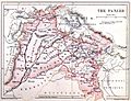
Map of the North-West Frontier Province, British India, published in 'The Panjab, North-West Frontier Province and Kashmir' (1916)
Map of the North-West Frontier Province and neighbouring regions (National Geographic, 1946)
As a separate province, the NWFP lasted until 1955 when it was merged into the new province of West Pakistan, under the One Unit policy announced by Prime MinisterChaudhry Mohammad Ali. It was recreated after the dissolution of the One Unit system and lasted under its old nomenclature until April 2010, when it was renamed the Khyber Pakhtunkhwa province.
Government
The offices of Governor and Chief Minister of the North-West Frontier Province lasted until 14 October 1955.
Historical population, language, and religious counts in North-West Frontier Province were enumerated in all districts (Hazara, Mardan, Peshawar, Kohat, Bannu, and Dera Ismail Khan), detailed in the population, language, and religious tables above and below. Separate population counts were taken in the Agencies and Tribal Areas, as detailed on the respective article page.
At independence, there was a clear Muslim Pashtun, Hindkowan, and Punjabi majority in the North-West Frontier Province, although there were also significant Hindu and Sikh Pashtun, Hindkowan, and Punjabi minorities scattered across the province.
Population of North–West Frontier Province by District (1855–1941)
The languages of the North-West Frontier Province included Pashto, Hindko, Kohistani and others, although most of the population spoke either Pashto or Lahnda/Western Punjabi (primarily Hindko and Saraiki). Prior to the arrival of the British, the official language, for governmental uses and such, was Persian.
Language in North–West Frontier Province (1881–1931)
Adherents of Islam who were indigenous to frontier regions that continued to have relatively large Hindu populations, and who were also relatively recent converts, were influenced by some traditions of Hinduism; in contrast, Muslims in frontier regions that had been further influenced by orthodox Islam and converted at a much earlier date were noted in their relatively different cultural habits.
"The high road, along which the Mohammedanconquerors and rulers of India passed and repassed lay through the north (the Khyber, Kurram and other routes); and it is probable that Islam never took so firm a hold of the inhabitants of the southern district as of the people to the north of them. In this connection it is interesting to notice that the Mussalman of the Derajat is less strict in his observance of the duties of his religion, such as fasts, prayers and the like, than his northern neighbours. Through Hazara lay the road by which the Emperors of Delhi went to and fro between the capital and their summer retreat in Kashmir, and it was natural that Islam should thoroughly permeate the district. Similarly Kohat, from its situation with regard to the Kurram Valley, which at no very distant period was, nominally at least, a portion of the Afghan kingdom, has been more influenced in the past by its Mohammedan neighbours to the west than have the districts to the south of it. There is no need to consider here the probable date at which the bulk of the Pathans living in the Province, or rather their ancestors, were converted to Islam. It is enough to notice that they had long been Mohammadan when they settled in their present homes, and that their fanaticism and intolerance, especially in the districts where they are strongest, rendered the Province no very inviting place of residence for settlers of a different creed. If no fanaticism in its inhabitants acted as a bar to the settlement of Hindus in Hazara, the absence of any large trade centres was at least equally efficacious. The only other district in which there is a non-Pathan element in the population in any way commensurate to that of Hazara is Dera Ismail Khan. The population here is mainly composed of tribes of Indian origin. Its conversion to Islam is of much later data; fanaticism does not exist, and no particular dislike to the Hindu seems to have existed."[10]:64–65
—Excerpt from the Census of India (North-West Frontier Province), 1911 AD
Similarly, adherents of Hinduism who belonged to the various castes and tribes who were indigenous to the frontier regions had considerable Islamic influence, owing to their status as a religious minority in the region for centuries, and thus formed religious syncretism that incorporated aspects from both faiths into their cultures and traditions.
"Hinduism, as it exists in the North-West Frontier Province, is but a pale reflection of the system which flourishes in the United Provinces and other areas to the east. Even of the Derajat, where, as we have seen, the Hindu population is proportionately most numerous, the writer of the Dera Ismail KhanGazetteer notes, "the Hindus of this district are less particular in the matter of caste prejudices and observances than down country Hindus. Most of them will drink water that has been carried in Mussaks (skins for carrying water) or out of lotas detached from a working well. They habitually ride on donkeys and do a multitude of other things which an orthodox Hindu would shrink from. All idolatrous observances are kept very much in the background. Except a few small images (thakurs) kept in their mandirs they have no idols at all. Nor is it their habit to take their gods about in procession. No one, in fact, sees anything of their worship. They burn their dead, and throw the ashes into the Indus. They always keep a few of the bones, and take them, when the opportunity offers, to the Ganges... There are a good many dharamsalas, mandirs, and dawaras at Dera Ismail Khan and in the cis-Industehsils."[10]:93
—Excerpt from the Census of India (North-West Frontier Province), 1911 AD
Lastly, decadal census reports throughout the colonial era frequently detailed the difficulty of differentiating adherents of Hinduism with adherents of Sikhism, owing to the traditional ability of the former in assimilating and integrating followers of varied thought into Hinduism.
"The Sikh religion was born out of Hinduism, and fears have been expressed of its being reabsorbed into it. Truly wonderful is the strength and vitality of Hinduism. It is like the boa constrictor of the Indian forests; when a petty enemy appears to worry it, it winds round its opponent, crushes it in its folds, and finally causes it to disappear in its capacious interior. In this way, many centuries ago, Hinduism on its own ground disposed of Buddhism which was largely a Hindu reformation in this way in a prehistoric period it absorbed the religion of the Scythian invaders of Northern India; in this way it has converted educated Islam in India into a semi-paganism; and in this way it is disposing of the reformed and once hopeful religion of Baba Nanak. Hinduism has embraced Sikhism in its folds; the still comparatively young religion is making a vigorous struggle for life, but its ultimate destruction is, it is apprehended, inevitable without State support. Notwithstanding the Sikh Guru's powerful denunciation of Brahmans, secularSikhs now rarely do anything without their assistance. Brahmans help them to be born, help them to wed, help them to die and help their souls after death to obtain a state of bliss. And Brahmans, with all the deftness of Roman Catholicmissionaries in Protestant countries have partially succeeded in persuading the Sikhs to restore to their niches the images of Devi, the Queen of Heaven, and the Saints and gods of the ancient faith."[10]:62
—Excerpt from the Census of India (North-West Frontier Province), 1911 AD)
Districts
Religion in North–West Frontier Province (1941)[13]:22
1 2 3 4 5 6 Includes speakers of Western Punjabi (Lahnda) (Hindko-Saraiki: Peshawari, Pahari-Pothwari, Derawali, Chinawab, Multani, Chachhi, Ghebi, Tanoli, Kohati, Awankari, Hariani, and others) and also includes speakers of Standard Punjabi. Both are included as one on table for continuity between censuses, as enumeration results frequently shifted as standardization of the various Punjabi dialects and languages was an ongoing process, with speakers of Standard Punjabi comprising a majority as per the 1911 census, while speakers of Western Punjabi (Lahnda) comprised a majority as per the 1921 and 1931 census.
This page is based on this Wikipedia article Text is available under the CC BY-SA 4.0 license; additional terms may apply. Images, videos and audio are available under their respective licenses.