Columbia-Lippincott Gazetteer. (New York: Columbia University Press, 1952) p.369
The Maharaja of Rewa, Raghuraj Singh Ju Deo Bahadur in 1877The Govindgarh palace of the Maharaja of Rewa in 1882
Rewa State, also known as Rewah, was a kingdom and later princely state of India, surrounding its eponymous capital, the town of Rewa.[citation needed]
Rewa was one of the largest princely states in the Bagelkhand Agency and the second largest in Central India Agency. Rewa was also the third-wealthiest principality in Central India, with an average revenue of 2.9 million rupees in 1901.[1] The Bagelkhand Agency was dissolved in 1933, following which Rewa was placed under the authority of the Indore Residency. Rewah state had a 15-gun salute.
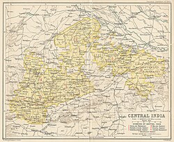
Central India Agency Map
History
According to legend, the kingdom of Rewa was founded around 1140 CE. On 5 October 1812, it became a British protectorate. Between 1 April 1875 and 15 October 1895, Rewa remained under the direct colonial administration of British India.[2]
The ruler of Rewa ruled from Bandhavgarh during the founding reign of Raja Vyaghra Dev, who was a direct descendant of Gujarati warrior king Vir Dhawal. In 1617, Maharaja Vikramaditya Singh moved his capital to Rewa. Maharaja Martand Singh was the last ruler of Rewa who acceded to the Union of India after the independence of India.[citation needed]
Akbar was given refuge at Rewa at age 10, when his father Humayun fled India following a defeat in war. Prince Ramchandra Singh and Akbar grew up together as royal heirs. Maharaja Ramchandra Singh and Akbar remained friends. In the mid-1550s, Raja Ramachandra Singh Baghela maintained a musically talented court, including the legendary Tansen. Two of the Navratnas of Akbar, Tansen and Birbal (originally named Mahesh Das) were sent from Rewa by Maharaja Ramchandra Singh once Akbar became Emperor of India. In 1580, Akbar reorganized his empire into 12 Subahs and combined the provinces of Jaunpur Sultanate, Kara-Manikpur and territory of Bandhogarh into the Subah of Ilahabad.[citation needed]
Raja Vishwanath Singh abolished Sati in the state under British pressure in 1847. During the Indian Rebellion of 1857, Rewa State sided with the British East India Company.[3] Rewa State was important for the British Raj from perspective of logistics as roads and railway lines connecting Gangetic plains to Deccan passed through the state.[3]
Rewa was the first princely state in India to declare Hindi the national language, in the times of Maharaja Gulab Singh. He is also credited for declaring the first responsive government in modern India, providing citizens of Rewa state a right to question their monarch's decisions.[citation needed]
During the long minority of Raja Venkat Raman Singh (b.1876, r.1880–1918), the administration of the state was reformed. In 1901, the town boasted a high school, a "model jail" and two hospitals: the Victoria hospital and the Zenana hospital. However, Lord Irwin criticized the lagging of state in terms of development and he spoke of Rewa's need to end its aloofness with the world and it was still adjudged among the most backward areas of the country by V.P. Menon, after he visited the state in 1947.[citation needed]
During Gulab Singh's reign, the state turned more towards autocracy and regional autonomy with tahsildars needing His Highness' permission for petty decisions.
Post-independence period
Upon India's independence in 1947, the maharaja of Rewa acceded unto the Dominion of India. Rewa later merged with the Union of India and became part of Vindhya Pradesh, which was formed by the merger of the former princely states of the Baghelkhand and Bundelkhand agencies. Rewa served as the capital of the new state.[4]
In 1956, Vindhya Pradesh was merged with other nearby political entities to form the Indian constitutive state of Madhya Pradesh. The Maharaja's palace was converted into a museum.[citation needed]
In February 2007, an extensive book on the history of Rewa, Baghelkhand, or the Tigers' Lair by Dr D.E.U Baker, was published by Oxford University Press.[citation needed]
Revolt of 1857
Thakur Ranmat Singh[5] of Mankahri revolted against the British and was hanged in 1859.
In the context of the 1857 Indian Rebellion, the princely state of Rewa in Madhya Pradesh played a significant role, but a controversial one. Thakur Ranmat Singh, a notable leader from Mankhari village in Satna district, emerged as a key figure in the uprising within the region. Holding the rank of Sardar in the Maharaja of Rewa's service, Thakur Ranmat Singh became increasingly discontented with British interference, particularly by the Resident Political Agent, Willoughby Osborne.
Inspired by the rebellion's broader momentum, Ranmat Singh led a formidable group of 2,000 rebels, besieging Osborne's bungalow. Although Osborne escaped, the rebels continued their struggle, engaging in multiple battles across areas like Nagod, Bhilsain, Chitrakoot, Nowgong, and Keoti. These activities made Thakur Ranmat Singh a significant threat to British control in the area [6][7]
However, the Maharaja of Rewa, under British pressure, eventually turned against Ranmat Singh. Despite initial sympathies for his cause, the Maharaja facilitated Ranmat Singh's capture. Thakur Ranmat Singh was arrested, charged with the murder of Europeans, and hanged in August 1860.[8]
This betrayal by the Rewa state highlights the complexities and internal conflicts during the 1857 Rebellion, where loyalty and resistance often intertwined in the fight against colonial rule.
The predecessor state, Bandhogarh, was founded c. 1140. Vyaghra Deo, a brother of a ruler of Gujarat, is said to have made his way into northern India around the middle of the 13th century and gained the fort of Marpha, 29km (18mi) north-east of Kalinjar. His son Karandeo, married a Kalchuri (Haihaya) princess of Mandla, and received in dowry the fort of Bandhogarh which, until its destruction in 1597 by Akbar, was the Baghel capital. In 1298, Ulugh Khan, acting under orders of the sultan of Delhi, Alauddin Khilji, drove the last Vaghela ruler of Gujarat from his country and this is believed to have caused a considerable migration of Baghels to Bandhogarh. Until the 15th century, the Baghels of Bandhogarh were engaged in extending their possessions and escaped the attention of the Delhi Sultans, in 1498–1499, Sikandar Lodi failed in his attempt to take the fort of Bandhogarh.[citation needed]
List of rulers
The following is a list of known rulers of Rewa (or its predecessor state, Bandhogarh), in chronological order by their reign. They took the title of Raja or, from 1857, Maharaja.
Maharaja Vyaghra Ju Deo
Maharaja Karan Ju Deo
Maharaja Sohag Ju Deo
Maharaja Sarang Deo
Maharaja Vilas Deo, established the Bilaspur city.
Maharaja Bhimal Deo
Maharaja Anik Deo [Ranik Deo]
Maharaja Valan Deo
Maharaja Dalkeshwar Deo
Maharaja Malkeshwar Deo
Maharaja Variyar Deo
Maharaja Bullar Deo
Maharaja Singh Deo
Maharaja Bhairam Deo
Maharaja Narhari Deo
Maharaja Bheer Deo
Maharaja Shalivahan Deo, r.1495–1500, Raja of Bandhogarh
Maharaja Veer Singh Deo, r. 1500–1540, established the town of Birsinghpur.
Maharaja Virbhan Singh, r. 1540–1555; fought against Sher Shah with Chandela Rajputs during the siege of Kalinjar Fort
Maharaja Ramchandra Singh, r.1555–1592
Maharaja Birbhadra Singh Deo, 1592-1602
Maharaja Duryodhan Singh (illegitimate son of Birbhadra Singh Deo), 1602-1618,(deposed). His accession gave rise to disturbances. Akbar intervened, captured and dismantled the Bandhogarh fort in 1597, after a siege of eight months.
Maharaja Vikramaditya Deo, r.1618–1630. He founded the town of Rewa in 1618 (which perhaps means that he undertook the construction of palaces and other buildings there because the place had already assumed importance in 1554 when it was held by Jalal Khan, son of emperor Shershah Suri).
Maharaja Amar Singh II, r.1630–1643, established the town of Amarpatan.
Maharaja Anoop Singh Deo, r.1643–1660.
Maharaja Bhao Singh Deo, r.1660–1690. He married twice but died childless.
Maharaja Anirudh Singh Deo, r.1690–1700, a grandson of Raja Anoop Singh, he was adopted by and succeeded his childless uncle, Raja Bhao Singh.
Maharaja Avadhut Singh Deo, r.1700–1755. The state was sacked by Harde Sah of Panna, c.1731, causing the Raja to flee to Pratapgarh in Oudh (Awadh).
Maharaja Ajit Singh Deo, r.1755–1809. The state was sacked by Nayak Yashwantrao alias Shrimant Jaswantkubje from Bundelkhand. Several Kalchuri families died defending the state.
Maharaja Jai Singh Deo, b.1765, r.1809–1835. In 1812, a body of Pindaris raided Rewa from Mirzapur territory, for which Jai Singh was called upon to accede to a treaty acknowledging the protection of the British Government, and agreed to refer all disputes with neighbouring chiefs to their arbitration and to allow British troops in his territories.
Maharaja Raghuraj Singh Ju Deo Bahadur, b.1831, r.1854–1857 as Raja, then as Majaraja 1857–1880. He helped the British quell the uprisings in the neighbouring Mandla and Jabalpur districts in the mutiny of 1857. For this service, the Sohagpur (Shahdol) and Amarkantakparganas were restored to his rule (having been seized by the Marathas in the beginning of the century), and he was made the first Majaraja of Rewa, ruling until his death on 5 February 1880.
Maharaja Venkatraman Ramanuj Prasad Singh Ju Deo Bahadur, b.1876, r.1880–1918.
Maharaja Gulab Singh Deo Bahadur, b.1903, r.1918–1946 (deposed).
Maharaja Sajjan Singh of Ratlam (Regent), b.1880, r.1918–1919, 1922–1923.
Philip Bannerman Warburton (Interim), b.1878, r.1919.
Dewan Bahadur Brijmohan Nath Zutshi (Regent, President of Regency Council), b.1877, r.1920–1922.
Elliot James Dowell Colvin (Interim), b.1885, r.1922.
Maharaja Martand Singh Deo Bahadur, b.1923, r.1946–1995.
This page is based on this Wikipedia article Text is available under the CC BY-SA 4.0 license; additional terms may apply. Images, videos and audio are available under their respective licenses.


