
Novato is a city in northern Marin County, in the North Bay region of the San Francisco Bay Area, in the U.S. state of California. As of the 2010 United States Census, its population was 51,904. Novato is located about 10 miles (16 km) northwest of San Rafael and about 30 miles (48 km) north of San Francisco on U.S. 101. Novato has been called one of the best places to live in the U.S.
Bel Marin Keys is an unincorporated community in Marin County, California. It lies at an elevation of 10 feet.

Don Edwards San Francisco Bay National Wildlife Refuge (DESFBNWR) is a United States National Wildlife Refuge located in the southern part of San Francisco Bay, California. The Refuge headquarters and visitor center is located in the Baylands district of Fremont, next to Coyote Hills Regional Park, in Alameda County. The visitor center is on Marshlands Rd, off Thornton Ave.
The California Coastal Conservancy is a state agency in California established in 1976 to enhance coastal resources and access.

The Petaluma River is a river in the California counties of Sonoma and Marin that becomes a tidal slough for the majority of its length. The headwaters are in the area southwest of Cotati. The flow is generally southward through Petaluma's old town, where the waterway becomes navigable, and then flows another 10 mi (16 km) through tidal marshes before emptying into the northwest corner of San Pablo Bay.

Located in northern California the Suisun Marsh is the largest brackish water marsh on west coast of the United States of America. The marsh land is part of the San Francisco Bay tidal estuary, and subject to tidal ebb and flood. The marsh is home to many species of birds and other wildlife, and is formed by the confluence of the Sacramento and San Joaquin rivers between Martinez and Suisun City, California and several other smaller, local watersheds. Adjacent to Suisun Bay, the marsh is immediately west of the legally defined Sacramento-San Joaquin Delta as well as part of the San Francisco Bay estuary.

Lagunitas Creek is a 24 miles (39 km)-long northward-flowing stream in Marin County, California. It is critically important to the largest spawning runs of endangered coho salmon in the Central California Coast Coho salmon Evolutionary Significant Unit. The stream's headwaters begin on the northern slopes of Mt. Tamalpais in the Coast Range and terminate in southeast Tomales Bay, 1.5 miles (2.4 km) northwest of Point Reyes Station, California. Lagunitas Creek feeds several reservoirs on Mt. Tamalpais that supply a major portion of the county's drinking water.

Sonoma Creek is a 33.4-mile-long (53.8 km) stream in northern California. It is one of two principal drainages of southern Sonoma County, California, with headwaters rising in the rugged hills of Sugarloaf Ridge State Park and discharging to San Pablo Bay, the northern arm of San Francisco Bay. The watershed drained by Sonoma Creek is roughly equivalent to the wine region of Sonoma Valley, an area of about 170 square miles (440 km2). The State of California has designated the Sonoma Creek watershed as a “Critical Coastal Water Resource”. To the east of this generally rectangular watershed is the Napa River watershed, and to the west are the Petaluma River and Tolay Creek watersheds.
The Napa Sonoma Marsh is a wetland at the northern edge of San Pablo Bay, which is a northern arm of the San Francisco Bay in California, United States. This marsh has an area of 48,000 acres (194 km2), of which 13,000 acres (53 km2) are abandoned salt evaporation ponds. The United States Government has designated 13,000 acres (53 km2) in the Napa Sonoma Marsh as the San Pablo Bay National Wildlife Refuge.

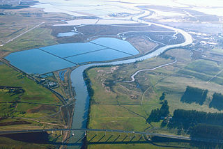
The Hamilton Wetland Restoration Project, now known as the Hamilton/Bel Marin Keys Wetlands Restoration is a wetlands habitat restoration project at the former Hamilton Air Force Base—Hamilton Army Airfield (1930−1988) site and adjacent Bel Marin Keys shoreline, in Marin County, California.

Novato Creek is a stream in eastern Marin County, California, United States. It originates in highlands between Red Hill and Mount Burdell above the city of Novato, California, and flows 17 miles (27 km) before emptying into San Pablo Bay south of Petaluma Point.

Miller Creek is a 7.6-mile-long (12.2 km) stream in eastern Marin County, California, United States. It originates on Big Rock Ridge and empties into San Pablo Bay east of Marinwood. A middle school called Miller Creek Middle School was named after the creek and is home to 6th, 7th, and 8th graders.

Alhambra Creek is a stream in Contra Costa County, in the East Bay region of the San Francisco Bay Area in northern California.
The Dotson Family Marsh, formerly Breuner Marsh, is a 238-acre regional park on San Pablo Bay in the East San Francisco Bay Area city of Richmond, California, In 2009 the East Bay Regional Parks District acquired the Breuner Marsh site, adding it to Point Pinole Regional Shoreline. A habitat restoration plan for 60 acres of wetlands and 90 acres of California coastal prairie was subsequently approved.
The environment of California describes results of human habitation of the State of California.
Chelsea Wetlands is a riparian marsh on lower Pinole Creek and a tidal wetland at its mouth on San Pablo Bay, in Contra Costa County, northern California. It is located within the city of Hercules, in the East Bay region of the San Francisco Bay Area.
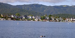
Whiteside Marsh is a coastal estuary marsh and wetlands on the northwestern shore of San Pablo Bay in southeastern Marin County, California. It is in and adjacent to the city of Novato and the Bel Marin Keys community, in the North Bay region of the San Francisco Bay Area.

Coyote Creek is a stream in the Richardson Bay watershed, draining Tamalpais-Homestead Valley, California eastward into Richardson Bay, Marin County, California, United States. The stream originates on Coyote Ridge and flows 2.5 miles (4.0 km) to the bay at the south end of Bothin Marsh.

Corte Madera Creek is a short stream which flows southeast for 4.5 miles (7.2 km) in Marin County, California. Corte Madera Creek is formed by the confluence of San Anselmo Creek and Ross Creek in Ross and entering a tidal marsh at Kentfield before connecting to San Francisco Bay near Corte Madera.

The Palo Alto Baylands Nature Preserve, known officially as the Baylands Nature Preserve, is the largest tract of undisturbed marshland remaining in the San Francisco Bay. Fifteen miles of multi-use trails provide access to a unique mixture of tidal and fresh water habitats. The preserve encompasses 1,940 acres in both Palo Alto and East Palo Alto, and is owned by the city of Palo Alto, California, United States. It is an important habitat for migratory shorebirds and is considered one of the best birdwatching spots on the West Coast.


