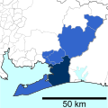
Chūkyō (中京圏, Chūkyō-ken), or the Chūkyō region (中京地方, Chūkyō-chihō), is a major metropolitan area in Japan that is centered on the city of Nagoya (the "Chūkyō", i.e., the "capital in the middle") in Aichi Prefecture. The area makes up the most urbanized part of the Tōkai region. The population of 10,110,000 over an area of 7,072 square kilometers.[2] Nevertheless, like most of Japan's major metro areas, the core of it lies on a fertile alluvial plain, in this case, the Nōbi Plain.
It is among the 50 most populous metropolitan areas in the world, and is the third most populous metropolitan area in Japan (after Greater Tokyo and Osaka-Kobe-Kyoto), containing roughly 7% of Japan's population. Historically, this region has taken a back seat to the other two power centers, both politically and economically; however, the agglomeration of Nagoya is the world's 22nd-largest metro area economy, in terms of gross metropolitan product at purchasing power parity in 2014, according to a study by the Brookings Institution.[5] The GDP of Greater Nagoya, Nagoya Metropolitan Employment Area, was US$256.3 billion in 2010.[3][6]
Prefecture
Gross prefecture product (in billion JP¥, 2021) [1]
The metropolitan area stretches beyond the central city of Nagoya to other municipalities in Aichi Prefecture, as well as neighboring Gifu and Mieprefectures.
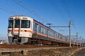
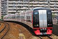
There are at least 38 passenger train lines in the Greater Nagoya area. JR runs six, Nagoya Subway seven, Meitetsu 18, Kintetsu four, and five other operators one each.
Per Japanese census data,[7][8][9] and[10][circular reference] , Chūkyō metropolitan area, also known as greater Nagoya, has had continuous population growth.
The area defined by the Chukyo Area Person-Trip Survey, a study of commuter movement, is slightly different from the census definition. It includes southern Aichi and areas immediately north of Gifu City. It adds two cities in Aichi Prefecture (Tahara and Toyohashi) and two cities in Gifu Prefecture (Mino and Seki). Additionally, it excludes two cities in Gifu Prefecture (Ena and Nakatsugawa).
The Chūbu region, Central region, or Central Japan is a region in the middle of Honshū, Japan's main island. In a wide, classical definition, it encompasses nine prefectures (ken): Aichi, Fukui, Gifu, Ishikawa, Nagano, Niigata, Shizuoka, Toyama, and Yamanashi.
The Tōkai region is a subregion of the Chūbu region and Kansai region in Japan that runs along the Pacific Ocean. The name comes from the Tōkaidō, one of the Edo Five Routes. Because Tōkai is a sub-region and is not officially classified, there is some disagreement about where exactly the region begins and ends, however Japanese maps widely conclude that the region includes Shizuoka, Aichi, Gifu and Mie prefectures.
Gifu Prefecture is a prefecture of Japan located in the Chūbu region of Honshu. Gifu Prefecture has a population of 1,991,390 and has a geographic area of 10,621 square kilometres (4,101 sq mi). Gifu Prefecture borders Toyama Prefecture to the north; Ishikawa Prefecture to the northwest, Fukui Prefecture and Shiga Prefecture to the west, Mie Prefecture to the southwest, Aichi Prefecture to the south, and Nagano Prefecture to the east.
Hashima is a city located in Gifu, Japan. As of 1 January 2019, the city had an estimated population of 67,909 in 26,327 households, and a population density of 1300 persons per km2, in 26,367 households. The total area of the city is 53.66 square kilometres (20.72 sq mi).
Kakamigahara is a city located in southern Gifu Prefecture in Japan. As of 1 January 2019, the city had an estimated population of 148,225, and a population density of 1700 persons per km2, in 59,736 households. The total area of the city was 87.81 km2 (33.90 sq mi).
Ichinomiya is a city located in Aichi Prefecture, Japan. The city is sometimes called Owarichinomiya to avoid confusion with other municipalities of the same name, including Ichinomiya and Ichinomiya in Chiba Prefecture. As of 1 October 2019, the city had an estimated population of 379,654 in 161,434 households, and a population density of 3,336 persons per km2. The total area of the city was 113.82 square kilometres (43.95 sq mi).
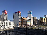
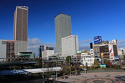
Nagoya Station is a major railway station in Nakamura-ku, Nagoya, Japan. It is Japan's, and one of the world's largest train stations by floor area, and houses the headquarters of the Central Japan Railway Company. Much of this space is located in the JR Central Towers atop the station, as well as in underground concourses. The current station complex was completed on December 20, 1999. The station and the area around it is officially called Meieki (名駅) in the Japanese addressing system.
Aichi Prefecture is a prefecture of Japan located in the Chūbu region of Honshū. Aichi Prefecture has a population of 7,552,873 and a geographic area of 5,172.92 square kilometres (1,997.28 sq mi) with a population density of 1,460 inhabitants per square kilometre (3,800/sq mi). Aichi Prefecture borders Mie Prefecture to the west, Gifu Prefecture and Nagano Prefecture to the north, and Shizuoka Prefecture to the east. Nagoya is the capital and largest city of the prefecture.
Nagoya Railroad Co., Ltd., often abbreviated to as Meitetsu (名鉄), is a private railway company operating around Aichi Prefecture and Gifu Prefecture of Japan. TYO: 9048
JOCH-DTV, branded as Chukyo TV, is the Chūkyō metropolitan area flagship station of the Nippon News Network and Nippon Television Network System (NNS), owned by the Chukyo TV. Broadcasting Co., Ltd.. Its studios are located in Nakamura-ku, Nagoya, Japan.
Meitetsu Nagoya Station is the principal station of the Nagoya Railroad (Meitetsu) system in Nagoya, Japan. Most trains of Meitetsu's major lines operate through this station. The station is also a gateway to the Chubu Centrair International Airport, which is connected with the station by the Rapid Express service started on January 29, 2005.
Kanayama Station is a railway station in Nagoya, Aichi Prefecture, Japan. The station is a concentrated terminal operated by Central Japan Railway Company, Nagoya Railroad (Meitetsu), and Nagoya Municipal Subway, and is the main access terminal to Chūbu Centrair International Airport.
Chubu-Nippon Broadcasting Co., Ltd. is a regional radio and television service serving Nagoya, Aichi Prefecture, Japan. It is majorly owned by the Chunichi Shimbun. Its radio service is affiliated with the Japan Radio Network (JRN) and its television service affiliated with the Japan News Network (JNN).
Kintetsu-Nagoya Station is a terminal station on the Kintetsu Nagoya Line. It is connected to Nagoya Station and Meitetsu Nagoya Station.
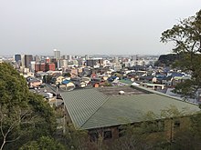
Tōnō (東濃) is the southeastern portion of Gifu Prefecture in the Chūbu region of Japan. The Tōnō region received its name as a combination of the kanji for "east" (東) and "Mino" (美濃). The borders of this region are not officially set, but it generally consists of the following cities: Tajimi, Toki, Mizunami, Ena and Nakatsugawa. Occasionally, Kani, usually part of the Chūnō region, is also included as being part of Tōnō.
The Nagoya Municipal Subway, also referred to as simply the Nagoya Subway, is a rapid transit system serving Nagoya, the capital of Aichi Prefecture in Japan. It consists of six lines that cover 93.3 kilometers (58.0 mi) of route and serve 87 stations. Approximately 90% of the subway's total track length is underground.
TOICA is a rechargeable contactless smart card ticketing system for JR Central railway network which was introduced in the Chūkyō Area of Japan on November 25, 2006. The name is an acronym for Tōkai IC Card. Like JR East's Suica or JR West's ICOCA, the card uses RFID technology developed by Sony known as FeliCa.
The Meitetsu Nagoya Main Line or Nagoya Line is a railway line operated by the private railway operator Nagoya Railroad (Meitetsu), connecting Toyohashi Station in Toyohashi with Meitetsu Gifu Station in Gifu.
Agigawa Dam is a dam built on the Kiso River system, located in the Higashino section of Ena City, in Gifu Prefecture, Japan.
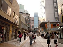
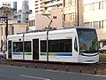
Transport in Greater Nagoya (Chūkyō) is similar to that of the Tokyo and Osaka, but is more automobile oriented, as the urban density is less than Japan's two primary metropolises, and major automobile manufacturers like Toyota are based here. Still, compared to most cities of its size worldwide it has a considerable rail transport network with 3 million passenger trips daily, with a similar density and extent of passenger rail to London or New York City, complemented with highways and surface streets for private motor transport. It includes public and private rail and highway networks; airports for international, domestic, and general aviation; buses; motorcycle delivery services, walking, bicycling, and commercial shipping. The nexus of the public transport system is Nagoya Station. Every region of Greater Nagoya, also known as the Chūkyō Metropolitan Area (中京圏), has rail or road transport services, and the area as a whole is served by sea and air links.
This page is based on this Wikipedia article Text is available under the CC BY-SA 4.0 license; additional terms may apply. Images, videos and audio are available under their respective licenses.