
Brooklyn is a borough of New York City. Located on the westernmost edge of Long Island, it is coextensive with Kings County in the U.S. state of New York. Kings County is the most populous county in the State of New York, and the second-most-densely-populated county in the United States, behind New York County (Manhattan). Brooklyn is also New York City's most populous borough, with 2,736,074 residents in 2020. If Brooklyn were an independent city, it would be the third most populous in the U.S. after the rest of New York City and Los Angeles, and ahead of Chicago.
The BMT Brighton Line, also known as the Brighton Beach Line, is a rapid transit line in the B Division of the New York City Subway in Brooklyn, New York City, United States. Local service is provided at all times by the Q train, but is joined by the B express train on weekdays. The Q train runs the length of the entire line from Coney Island–Stillwell Avenue to the Manhattan Bridge south tracks. The B begins at Brighton Beach and runs via the bridge's north tracks.

Midwood is a neighborhood in the south-central part of the New York City borough of Brooklyn. It is bounded on the north by the Bay Ridge Branch tracks just above Avenue I and by the Brooklyn College campus of the City University of New York, and on the south by Avenue P and Kings Highway. The eastern border consists of parts of Nostrand Avenue, Flatbush Avenue, and Coney Island Avenue; parts of McDonald Avenue and Ocean Parkway mark the western boundary.

Flatbush is a neighborhood in the New York City borough of Brooklyn. The neighborhood consists of several subsections in central Brooklyn and is generally bounded by Prospect Park to the north, East Flatbush to the east, Midwood to the south, and Kensington and Parkville to the west. The modern neighborhood includes or borders several institutions of note, including Brooklyn College.
Kensington is a neighborhood in the central portion of the New York City borough of Brooklyn, located south of Prospect Park and Green-Wood Cemetery. It is bordered by Coney Island Avenue to the east; Fort Hamilton Parkway and Caton Avenue to the north; McDonald Avenue and 36th Street to the west; and Ditmas Avenue or Foster Avenue to the south. Kensington and Parkville are bordered by the Prospect Park South and Ditmas Park subsections of Flatbush to the east; Windsor Terrace to the north; Borough Park to the west; and Midwood to the south.
Fiske Terrace is a planned community and neighborhood in the New York City borough of Brooklyn. Fiske Terrace is located in south central Brooklyn in the southern edge of the community of Flatbush and north of the community of Midwood. It is bounded by Glenwood Road on the north, Ocean Avenue on the east, the Bay Ridge Branch of the Long Island Rail Road/New York and Atlantic Railway right-of-way on the south, and the New York City Subway BMT Brighton Line subway line on the west.
Prospect Park South is a small neighborhood in Flatbush, Brooklyn, New York City, located south of Prospect Park. It is included within the Prospect Park South Historic District, which was designated by the New York City Landmarks Preservation Commission in 1979 and listed on the National Register of Historic Places in 1983. The historic district is bounded by Church Avenue to the north, the BMT Brighton Line of the New York City Subway to the east, Beverley Road to the south, and between Stratford Road and Coney Island Avenue to the west.

T.B. Ackerson Company was a real estate development company that built several planned communities in the New York metropolitan area during the late 19th and early 20th centuries.

Flatbush Avenue is a major avenue in the New York City Borough of Brooklyn. It runs from the Manhattan Bridge south-southeastward to Jamaica Bay, where it joins the Marine Parkway–Gil Hodges Memorial Bridge, which connects Brooklyn to the Rockaway Peninsula in Queens. The north end was extended from Fulton Street to the Manhattan Bridge as "Flatbush Avenue Extension".

Community boards of Brooklyn are New York City community boards in the borough of Brooklyn, which are the appointed advisory groups of the community districts that advise on land use and zoning, participate in the city budget process, and address service delivery in their district.

Ditmas Park is a historic district in the neighborhood of Flatbush in Brooklyn, New York City. The traditional boundaries of Ditmas Park, including Ditmas Park West, are Ocean Avenue and greater Flatbush to the east, Dorchester Road and the Prospect Park South neighborhood to the north, Coney Island Avenue and the Kensington neighborhood to the west, and Newkirk Avenue to the south. The name Ditmas Park is often used as a shorthand for the several neighborhoods that comprise the larger area of Victorian Flatbush.

Ocean Parkway is a 4.86-mile (7.82 km) boulevard in the west-central portion of the New York City borough of Brooklyn. It is inventoried by the New York State Department of Transportation (NYSDOT) as New York State Route 908H (NY 908H), an unsigned reference route.

The Avenue H station is a local station on the BMT Brighton Line of the New York City Subway. It is located at Avenue H between East 15th and East 16th Streets near the border of Midwood and Flatbush, Brooklyn. The station is served by the Q train at all times.

The Newkirk Plaza station is an express station on the BMT Brighton Line of the New York City Subway in Flatbush, Brooklyn. It is located on an open-cut at the center of the pedestrian-only Newkirk Plaza shopping mall, which is bounded by Newkirk Avenue on the north, Foster Avenue on the south, Marlborough Road to the west, and East 16th Street to the east. The station is served by the Q train at all times and by the B train on weekdays only.

The Avenue M station, is a local station on the BMT Brighton Line of the New York City Subway. It is located in Midwood, Brooklyn, at Avenue M between East 15th and East 16th Streets. The station is served by the Q train at all times.

The B82 bus route constitutes a public transit line in central Brooklyn, New York City. It connects Starrett City in southeast Brooklyn with Coney Island on Brooklyn's southwestern coast. The B82 operates primarily via Kings Highway and Flatlands Avenue in southern Brooklyn. The route is operated by MTA Regional Bus Operations, under the New York City Bus and Select Bus Service brands.
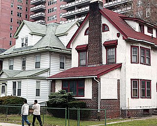
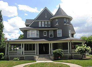
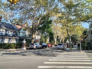
Victorian Flatbush is the western section of the Flatbush section of Brooklyn, New York, bordering Midwood, that is characterized by Victorian houses.
West Midwood is a planned community and historic enclave in the New York City borough of Brooklyn. West Midwood is located in central Brooklyn in the southern edge of the community of Victorian Flatbush, abutting the northern boundary of the community of Midwood. It is bordered by Foster Avenue to the north, the BMT Brighton subway line to the east, Avenue H to the south, and Coney Island Avenue to the west. West Midwood is located south of Prospect Park within what is sometimes referred to as Ditmas Park.
